Abita River (Click on an image to go to hydrograph webpage)
ASBL1:
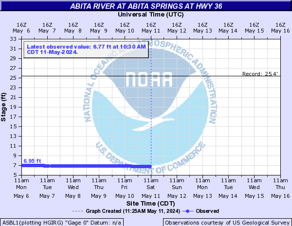
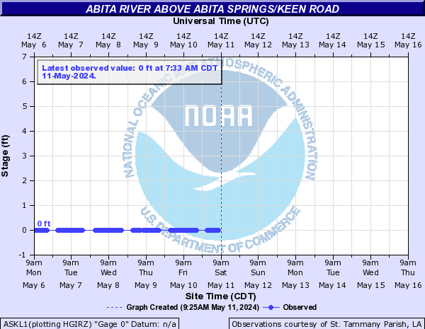
ASKL1:
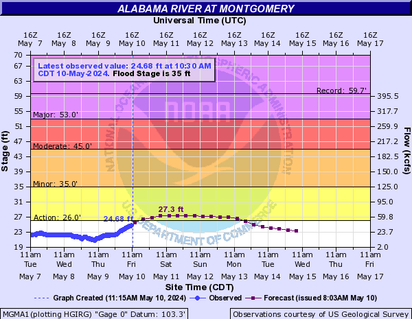
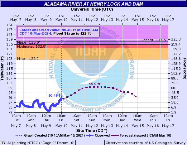
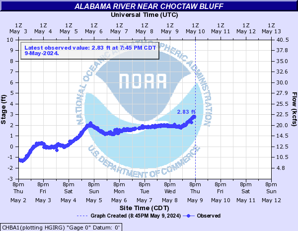
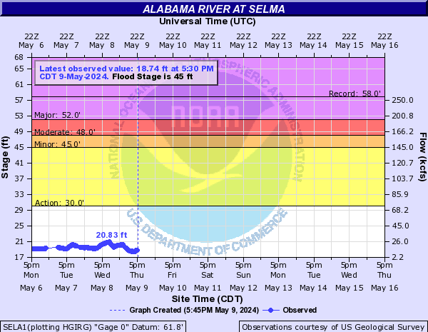
Alabama River (Click on an image to go to hydrograph webpage)
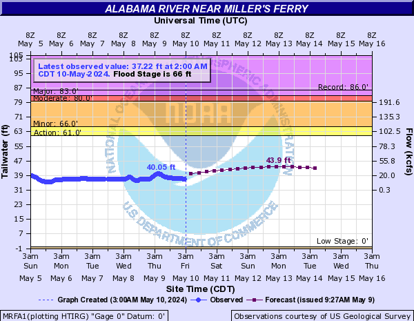
MRFA1:
MGMA1:
TYLA1:
CLBA1:

CHBA1:
SELA1:
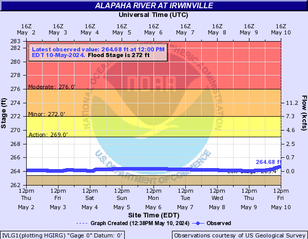
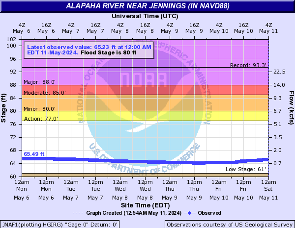
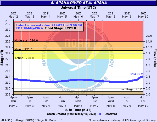
Alapaha River (Click on an image to go to hydrograph webpage)
STNG1:

IVLG1:
JNAF1:
ALAG1:
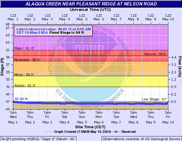
Alaqua Creek (Click on an image to go to hydrograph webpage)
ALQF1:
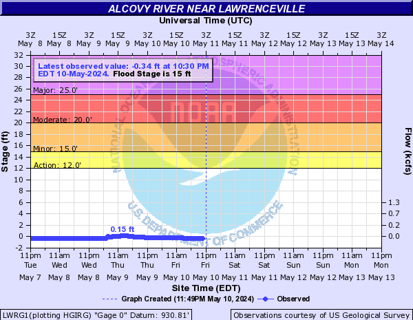
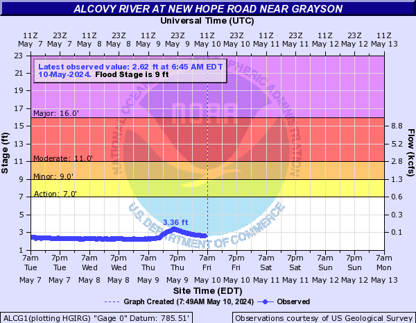
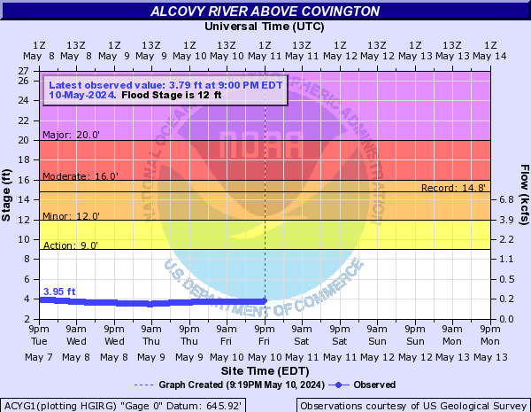
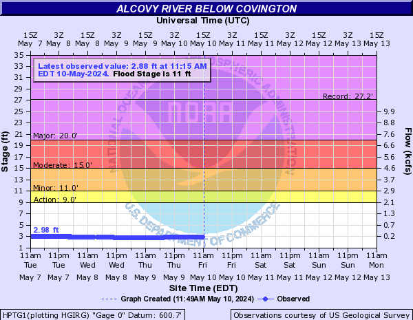
Alcovy River (Click on an image to go to hydrograph webpage)
LWRG1:
ALCG1:
ACYG1:
HPTG1:
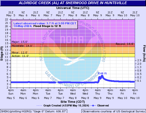
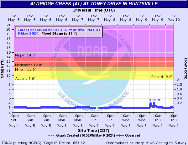
Aldridge Creek (AL) (Click on an image to go to hydrograph webpage)
FRYA1:

SHEA1:
TONA1:
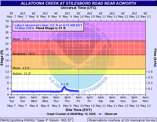
Allatoona Creek (Click on an image to go to hydrograph webpage)
MAHG1:
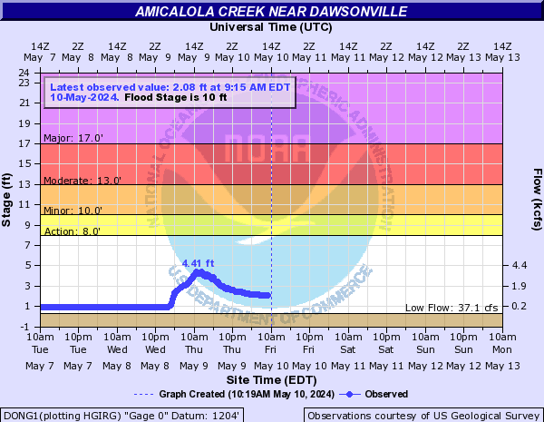
Amicalola Creek (Click on an image to go to hydrograph webpage)
DONG1:
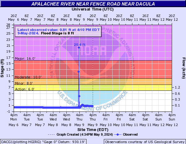
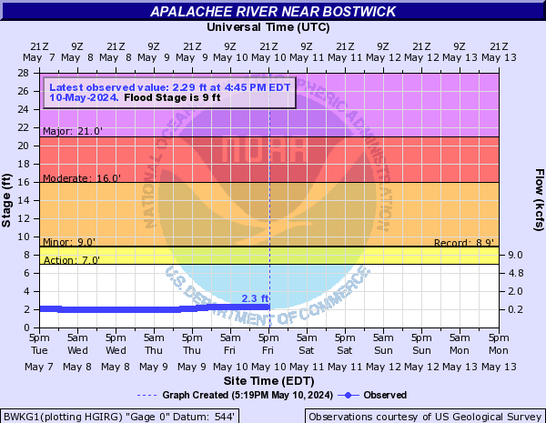
Apalachee River (Click on an image to go to hydrograph webpage)
DACG1:
BWKG1:
BHPG1:

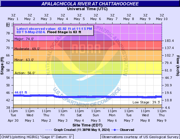
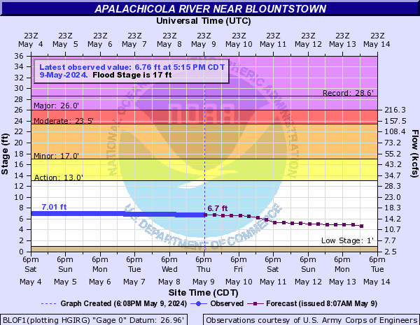
Apalachicola River (Click on an image to go to hydrograph webpage)
WDRF1:

CHAF1:
BLOF1:
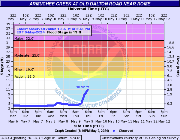
Armuchee Creek (Click on an image to go to hydrograph webpage)
ARCG1:
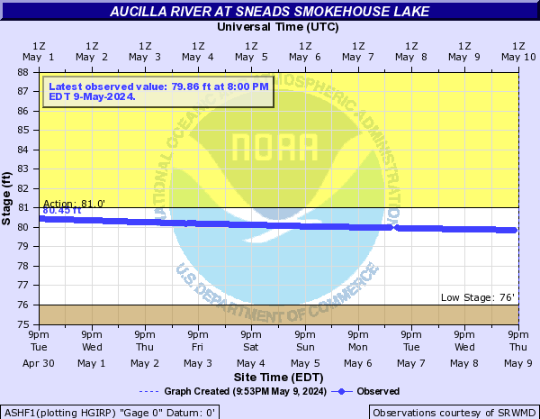
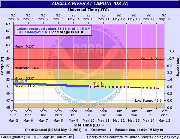
Aucilla River (Click on an image to go to hydrograph webpage)
ASHF1:
LAMF1:
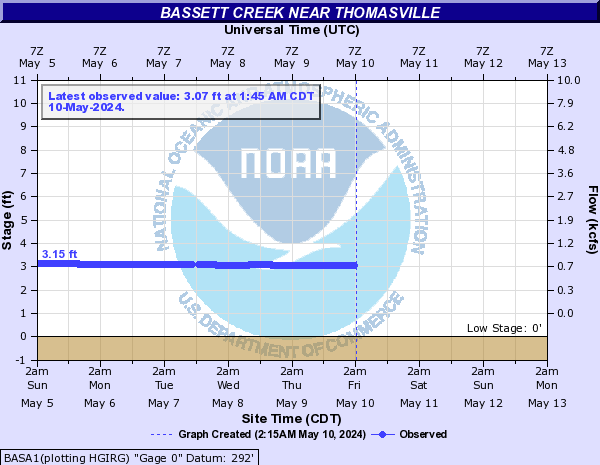
Bassett Creek (Click on an image to go to hydrograph webpage)
BASA1:
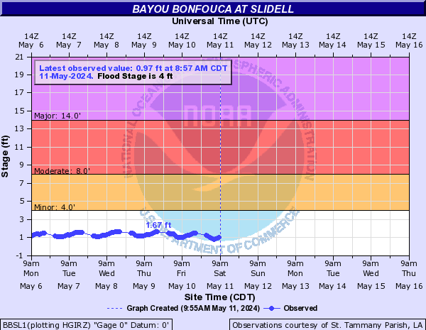
Bayou Bonfouca (Click on an image to go to hydrograph webpage)
BBSL1:
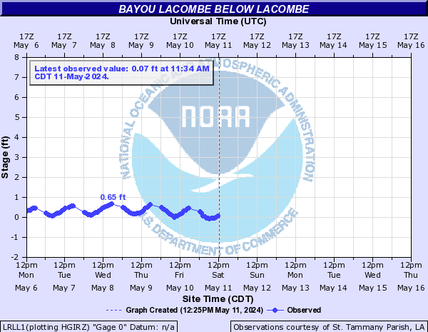
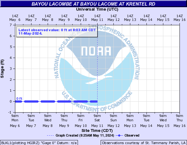
Bayou Lacombe (Click on an image to go to hydrograph webpage)
LRLL1:
BLKL1:
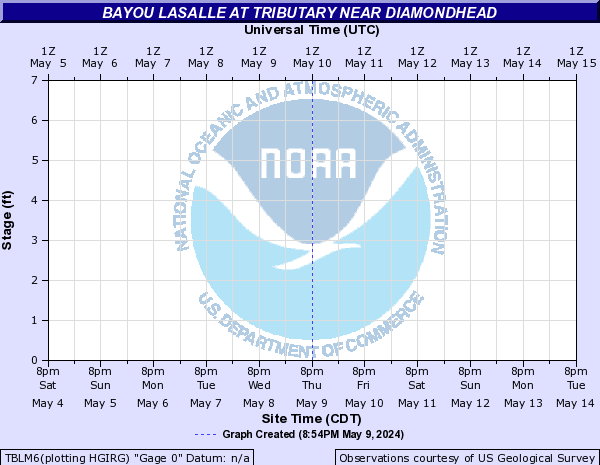
Bayou Lasalle (Click on an image to go to hydrograph webpage)
TBLM6:
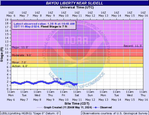
Bayou Liberty (Click on an image to go to hydrograph webpage)
LBSL1:
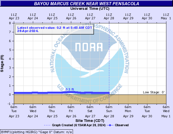
Bayou Marcus Creek (Click on an image to go to hydrograph webpage)
BYMF1:
Bayou Sara (Click on an image to go to hydrograph webpage)
SARA1:

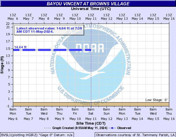
Bayou Vincent (Click on an image to go to hydrograph webpage)
BVSL1:
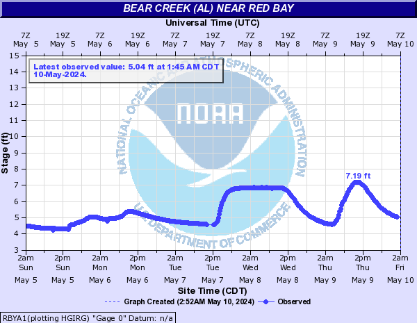
Bear Creek (Click on an image to go to hydrograph webpage)
BCDN7:

BEBF1:

Bear Creek (AL) (Click on an image to go to hydrograph webpage)
RBYA1:
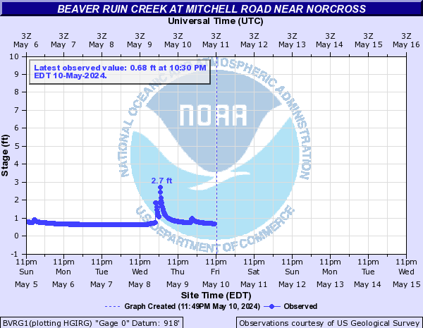
Beaver Ruin Creek (Click on an image to go to hydrograph webpage)
BVRG1:
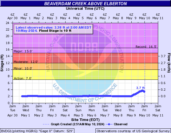
Beaverdam Creek (Click on an image to go to hydrograph webpage)
BVDG1:
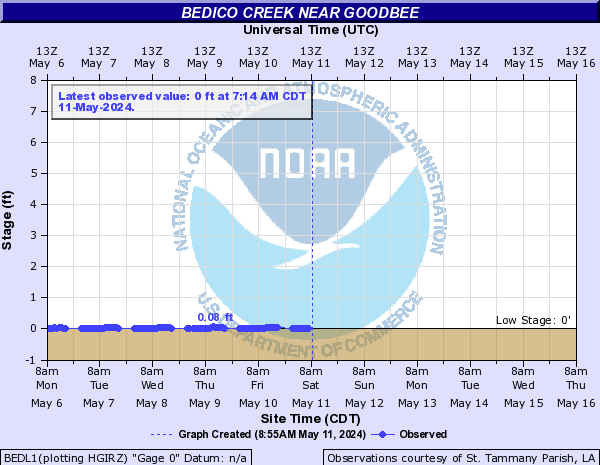
Bedico Creek (Click on an image to go to hydrograph webpage)
BEDL1:
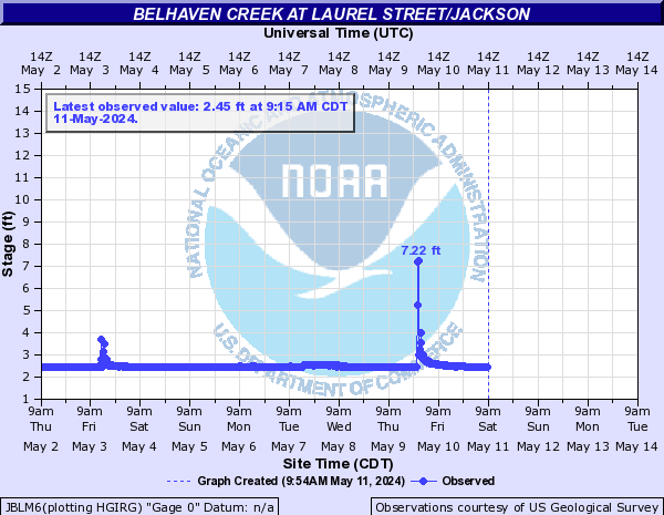
Belhaven Creek (Click on an image to go to hydrograph webpage)
JBRM6:
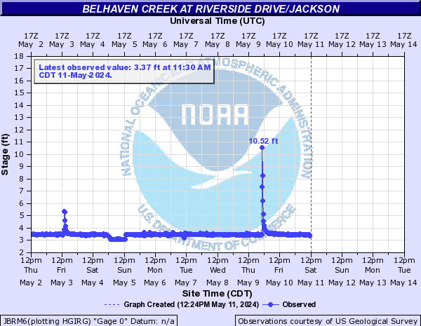
JBLM6:
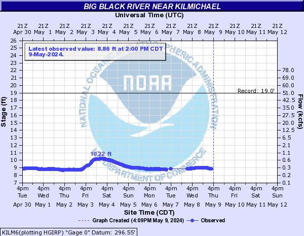
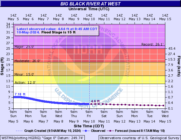
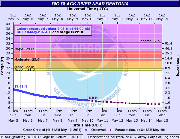
Big Black River (Click on an image to go to hydrograph webpage)
KILM6:
WSTM6:
BTAM6:
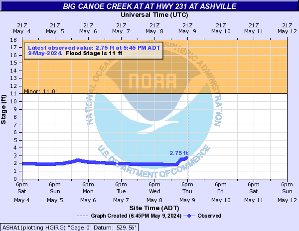
Big Canoe Creek (Click on an image to go to hydrograph webpage)
ASHA1:
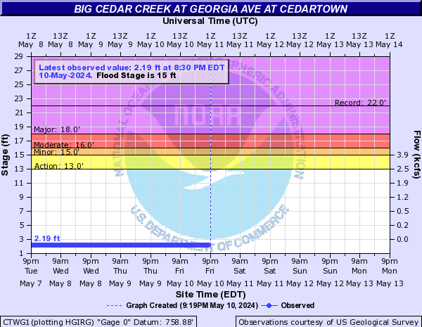
Big Cedar Creek (Click on an image to go to hydrograph webpage)
CTWG1:
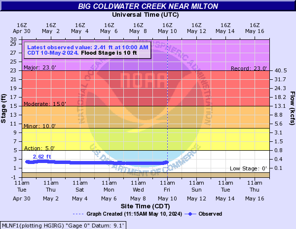
Big Coldwater Creek (Click on an image to go to hydrograph webpage)
MLNF1:
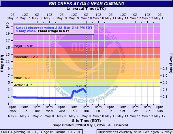
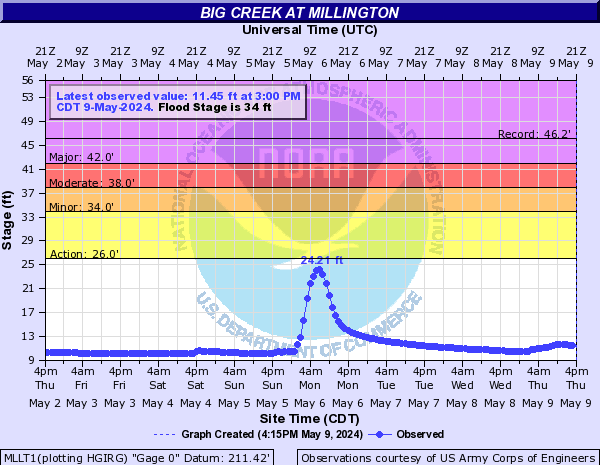
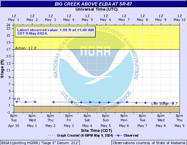
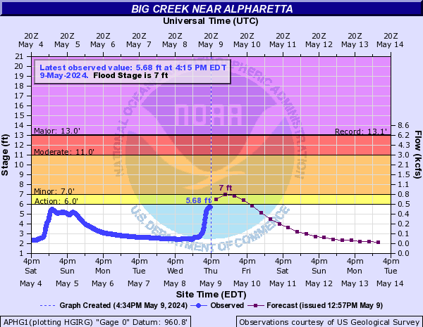
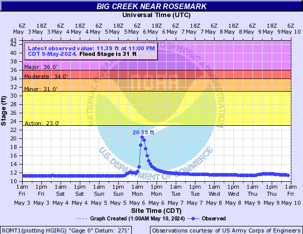
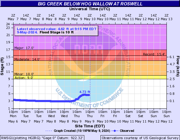
Big Creek (Click on an image to go to hydrograph webpage)
CMGG1:
MLLT1:
BIGA1:
APHG1:
ROMT1:
RWSG1:
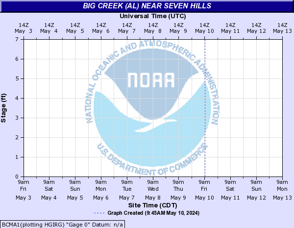
Big Creek (Al) (Click on an image to go to hydrograph webpage)
WILA1:

BCMA1:
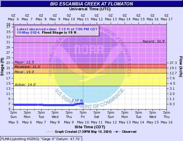
Big Escambia Creek (Click on an image to go to hydrograph webpage)
FLMA1:
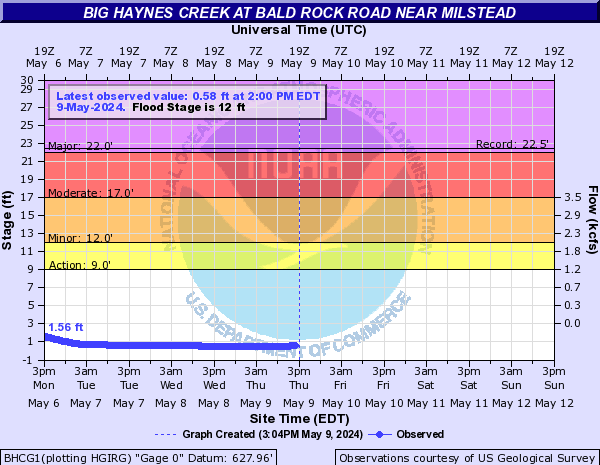
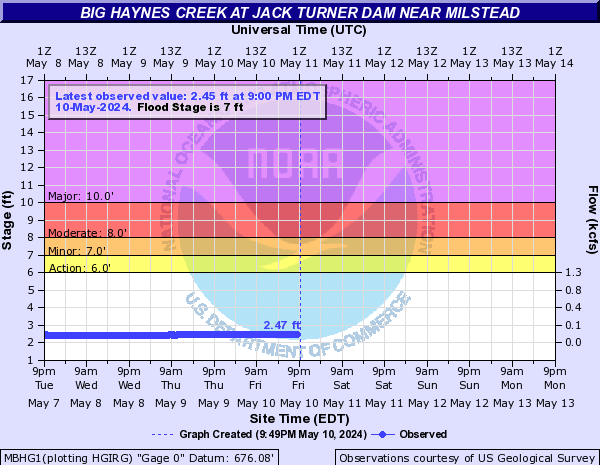
Big Haynes Creek (Click on an image to go to hydrograph webpage)
BHCG1:
BIGG1:

MBHG1:
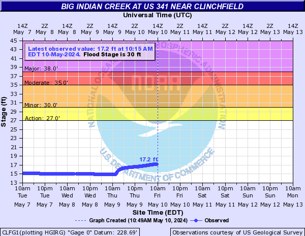
Big Indian Creek (Click on an image to go to hydrograph webpage)
CLFG1:
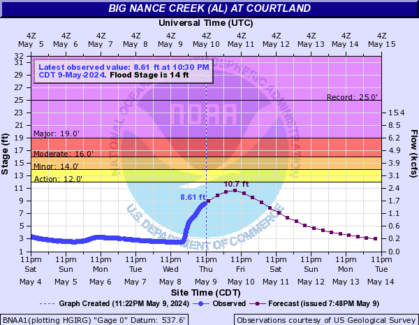
Big Nance Creek (AL) (Click on an image to go to hydrograph webpage)
BNAA1:
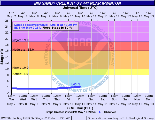
Big Sandy Creek (Click on an image to go to hydrograph webpage)
IWTG1:
Big Sunflower River (Click on an image to go to hydrograph webpage)
SUNM6:

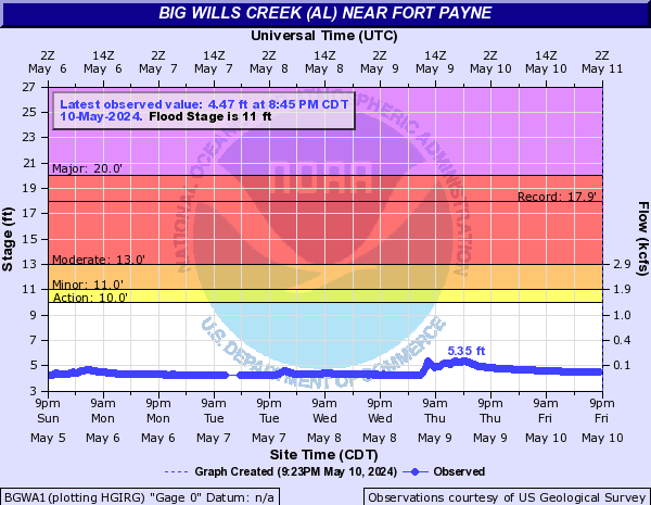
Big Wills Creek (AL) (Click on an image to go to hydrograph webpage)
BGWA1:
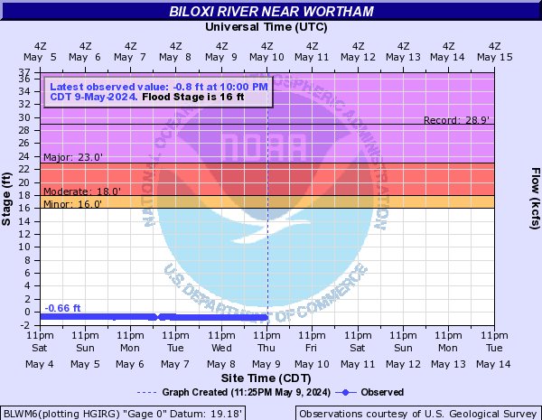
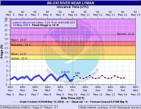
Biloxi River (Click on an image to go to hydrograph webpage)
BLWM6:
LYMM6:
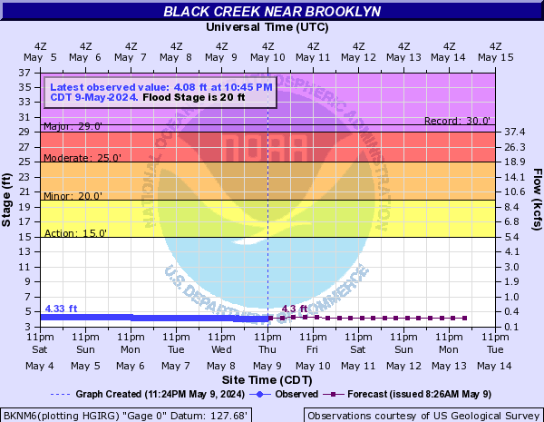
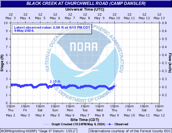
Black Creek (Click on an image to go to hydrograph webpage)
BKNM6:
BCRM6:
Black Creek (Wakulla) (Click on an image to go to hydrograph webpage)
BLBF1:

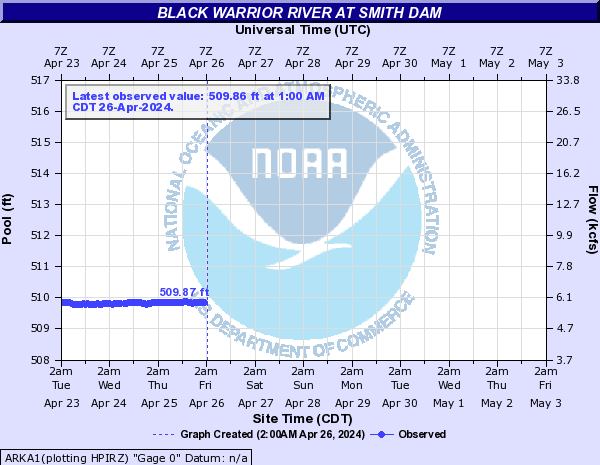
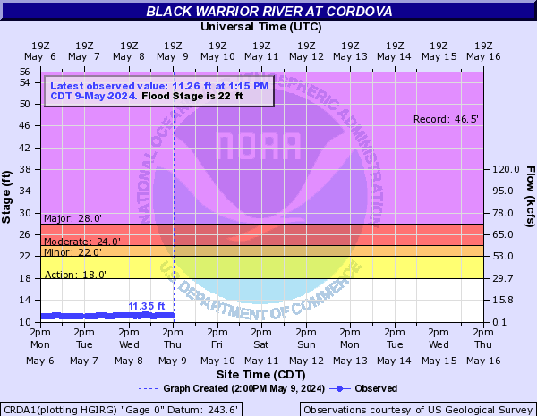
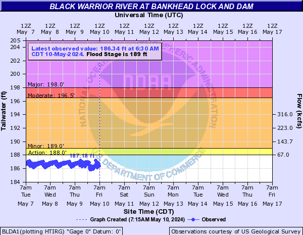
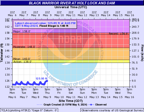
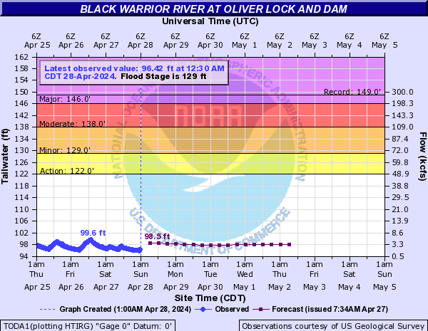
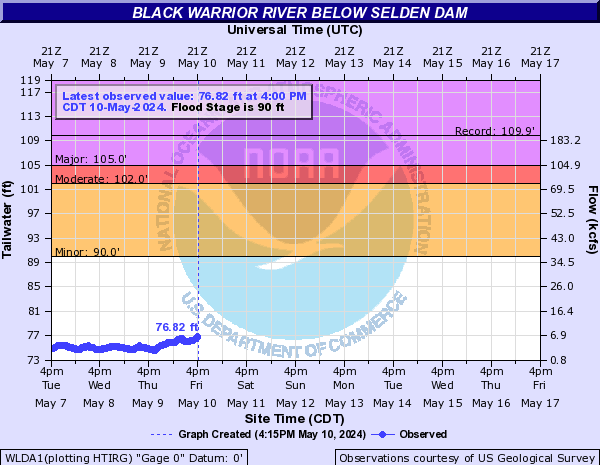
Black Warrior River (Click on an image to go to hydrograph webpage)
ARKA1:
CRDA1:
BLDA1:
TCLA1:
TODA1:
WLDA1:
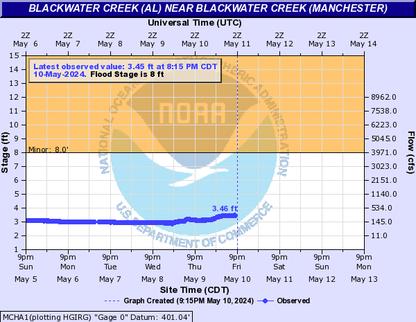
Blackwater Creek (AL) (Click on an image to go to hydrograph webpage)
MCHA1:
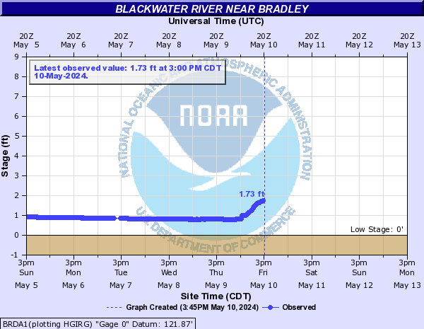
Blackwater River (Click on an image to go to hydrograph webpage)
BRDA1:
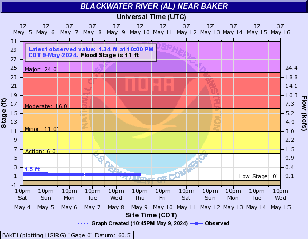
Blackwater River (AL) (Click on an image to go to hydrograph webpage)
BAKF1:
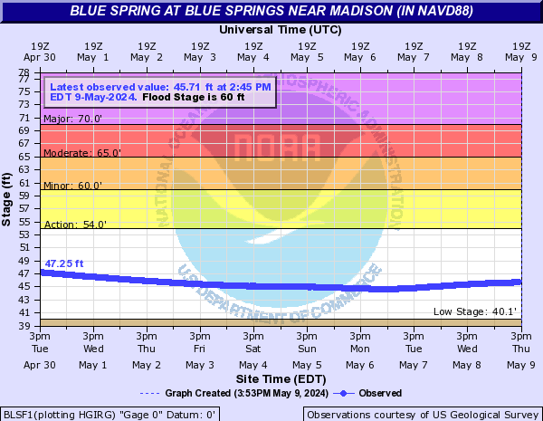
Blue Spring (Click on an image to go to hydrograph webpage)
BLSF1:
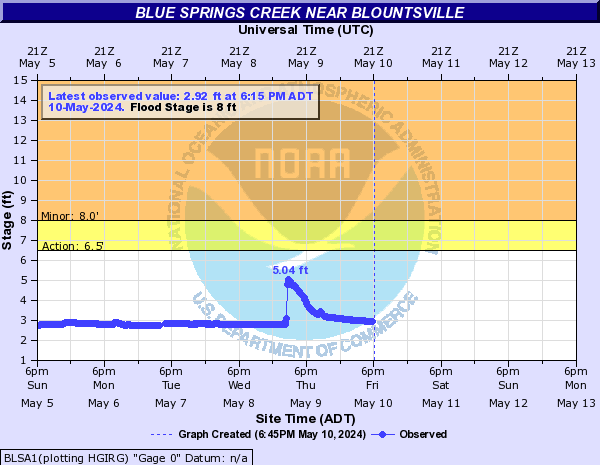
Blue Springs Creek (Click on an image to go to hydrograph webpage)
BLSA1:
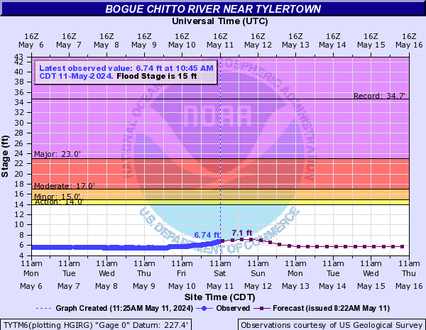
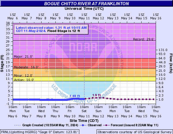
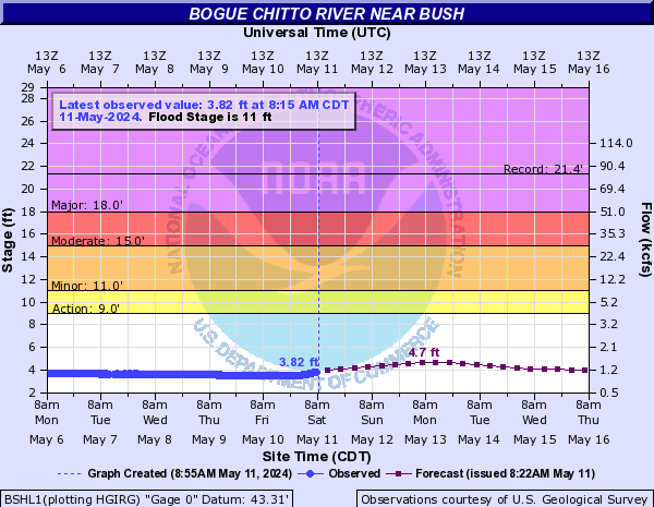
Bogue Chitto River (Click on an image to go to hydrograph webpage)
TYTM6:
FRNL1:
BSHL1:
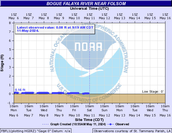
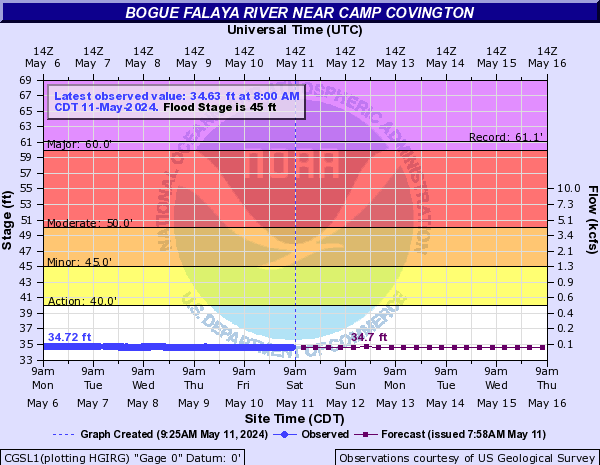
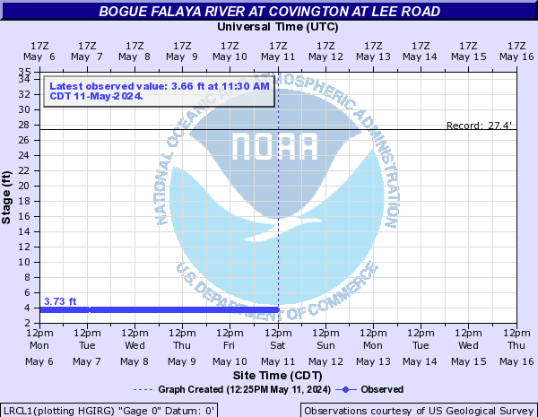
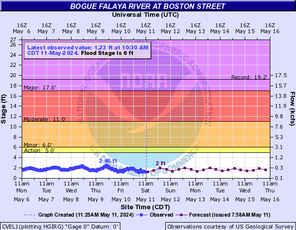
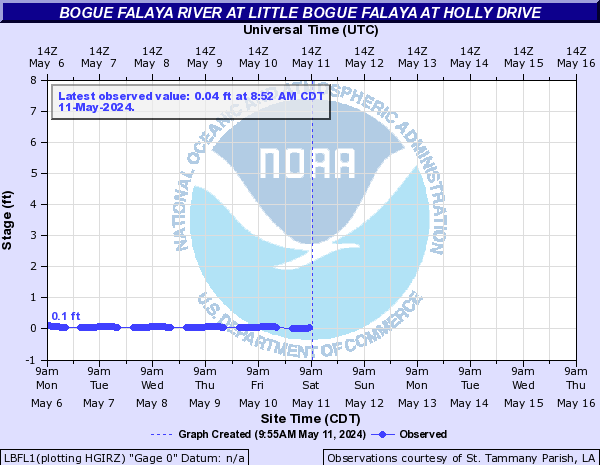
Bogue Falaya River (Click on an image to go to hydrograph webpage)
FBFL1:
CGSL1:
LRCL1:
CVEL1:
LBFL1:
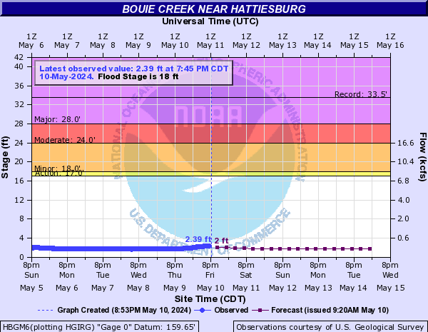
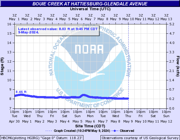
Bouie Creek (Click on an image to go to hydrograph webpage)
HBGM6:
HBCM6:
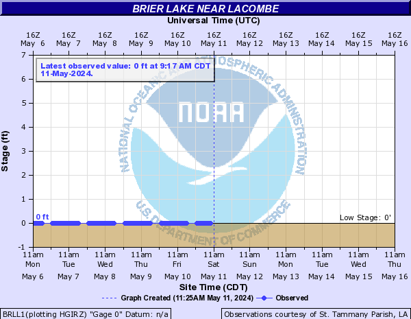
Brier Lake (Click on an image to go to hydrograph webpage)
BRLL1:
Broad River in GA (Click on an image to go to hydrograph webpage)
CARG1:

Bromolow Creek Tributary (Click on an image to go to hydrograph webpage)
BRMG1:
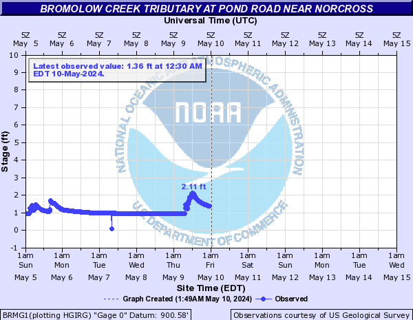
BRMG1:
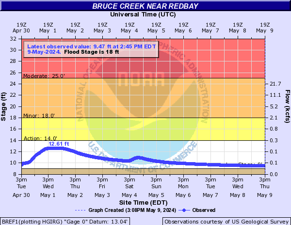
Bruce Creek (Click on an image to go to hydrograph webpage)
BREF1:
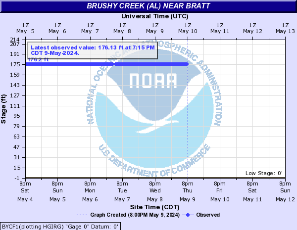
Brushy Creek (AL) (Click on an image to go to hydrograph webpage)
BYCF1:
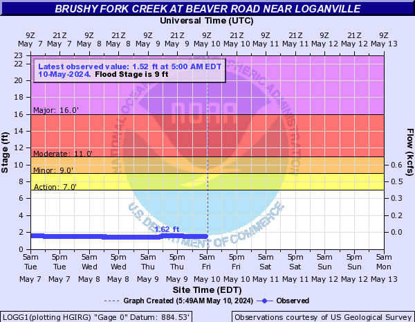
Brushy Fork Creek (Click on an image to go to hydrograph webpage)
LOGG1:
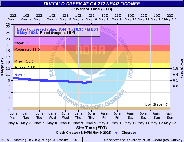
Buffalo Creek (Click on an image to go to hydrograph webpage)
BFOG1:
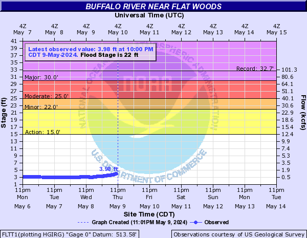
Buffalo River (Click on an image to go to hydrograph webpage)
FLTT1:
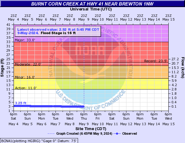
Burnt Corn Creek (Click on an image to go to hydrograph webpage)
BCNA1:
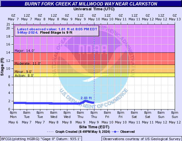
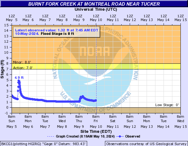
Burnt Fork Creek (Click on an image to go to hydrograph webpage)
BFCG1:
BKCG1:
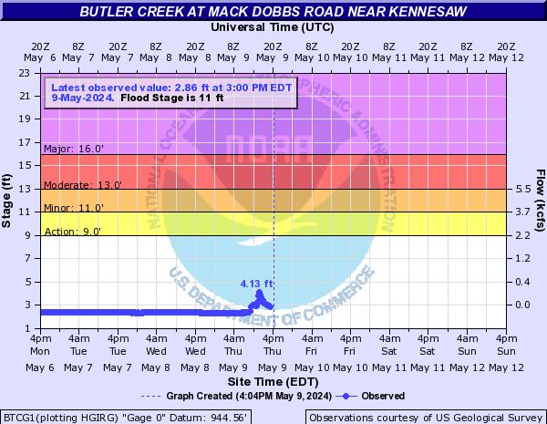
Butler Creek (Click on an image to go to hydrograph webpage)
BTCG1:
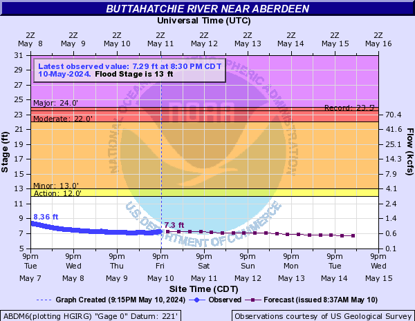
Buttahatchie River (Click on an image to go to hydrograph webpage)
ABDM6:
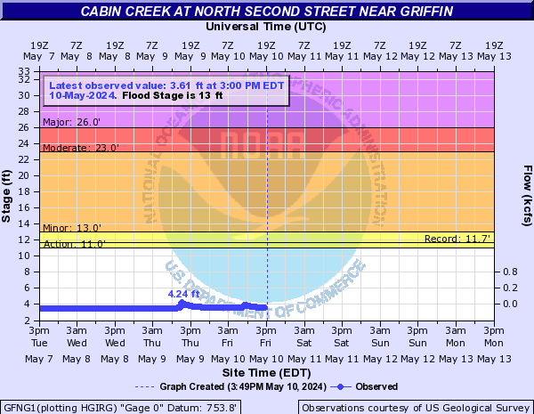
Cabin Creek (Click on an image to go to hydrograph webpage)
GFNG1:
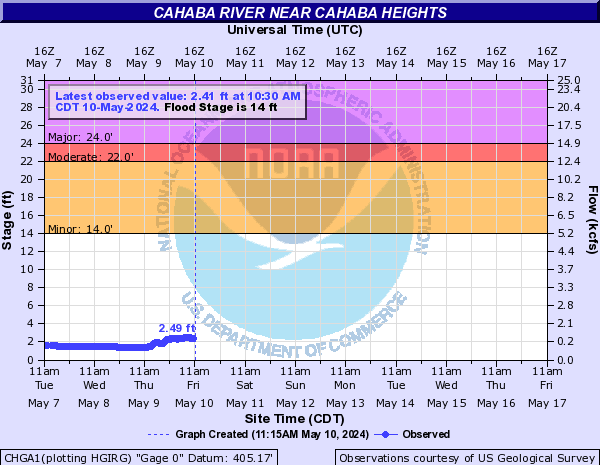
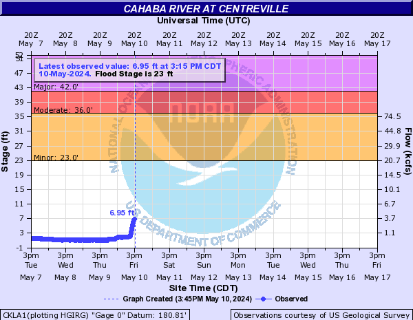
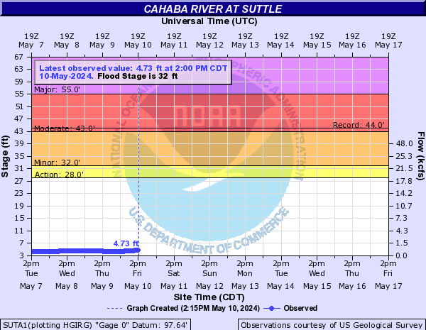
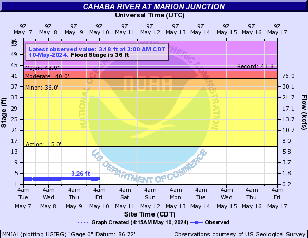
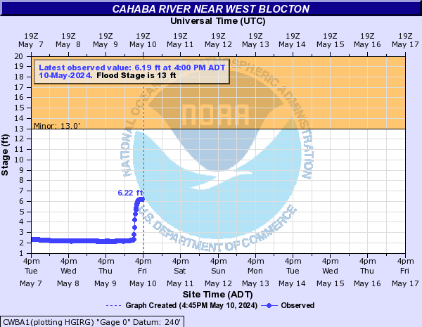
Cahaba River (Click on an image to go to hydrograph webpage)
CHGA1:
CKLA1:
SUTA1:
MNJA1:
CWBA1:
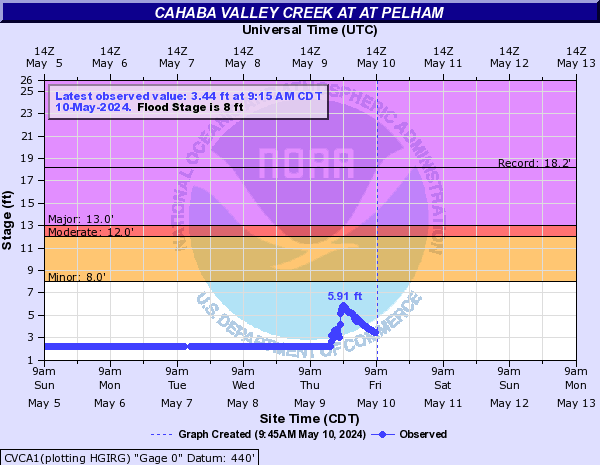
Cahaba Valley Creek (Click on an image to go to hydrograph webpage)
CVCA1:
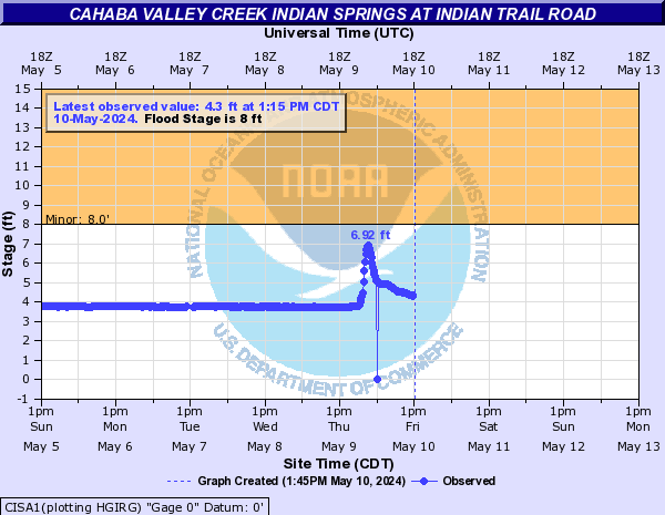
Cahaba Valley Creek Indian Springs (Click on an image to go to hydrograph webpage)
CISA1:
Camp Creek (Click on an image to go to hydrograph webpage)
CCKG1:

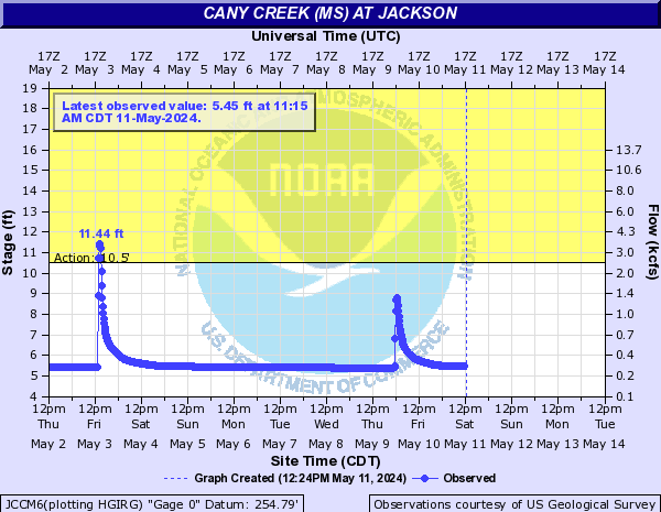
Cany Creek (MS) (Click on an image to go to hydrograph webpage)
JCCM6:
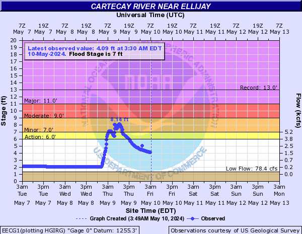
Cartecay River (Click on an image to go to hydrograph webpage)
EECG1:
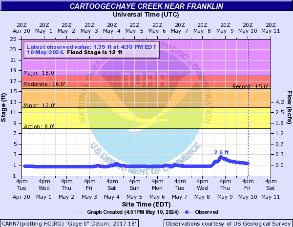
Cartoogechaye Creek (Click on an image to go to hydrograph webpage)
CARN7:
Catoma Creek (Click on an image to go to hydrograph webpage)
CATA1:

Cedar Creek (Click on an image to go to hydrograph webpage)
CCDG1:

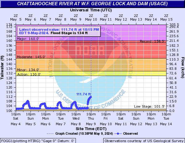
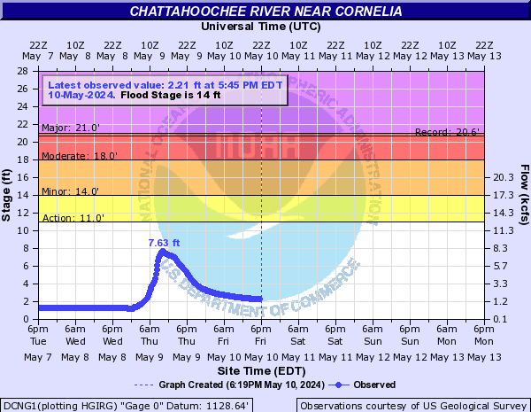
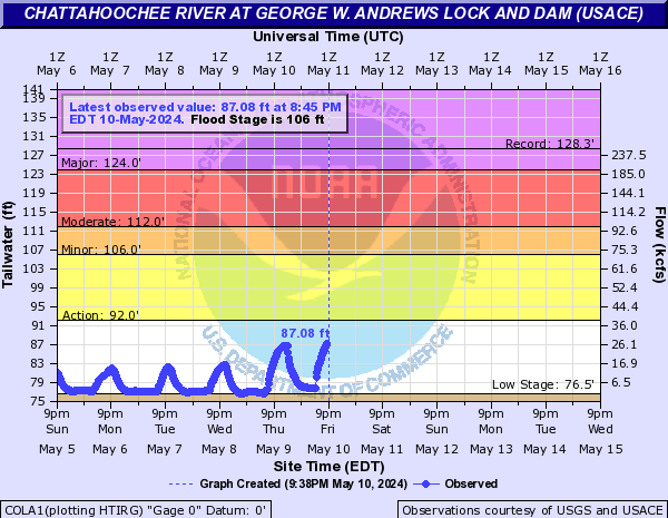
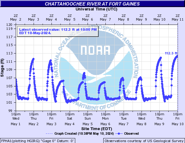
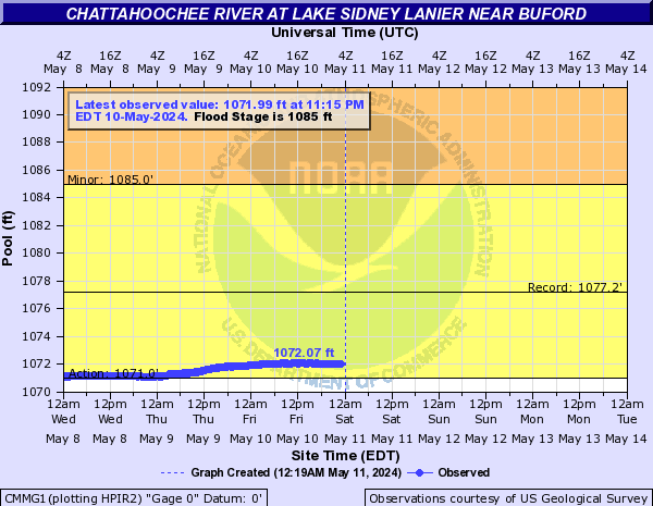
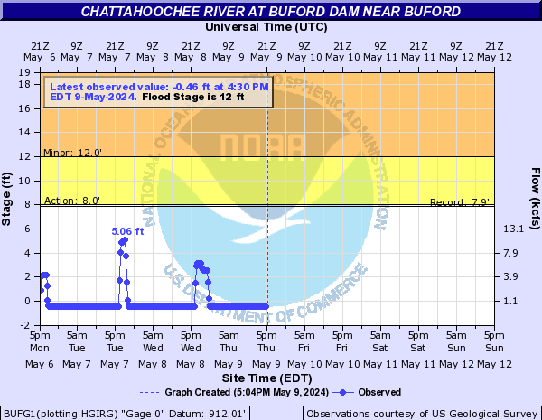
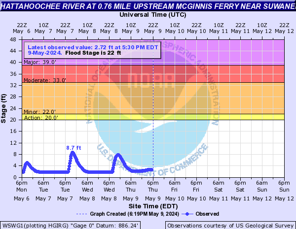
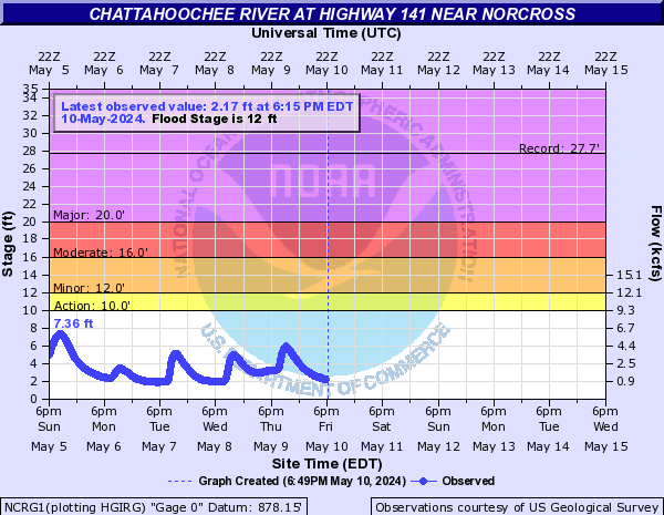
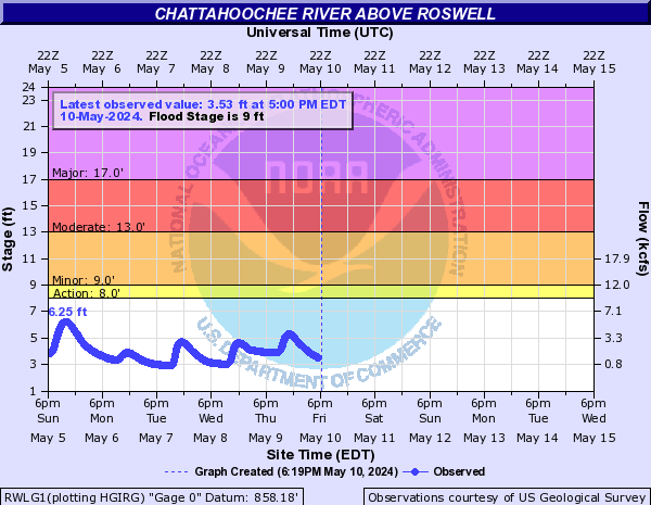
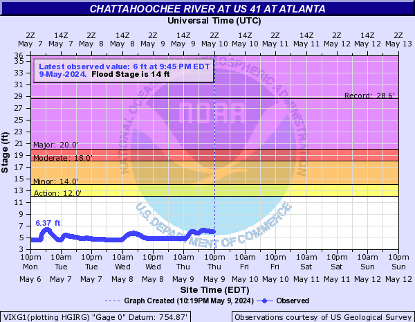
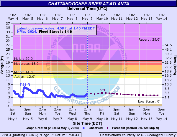
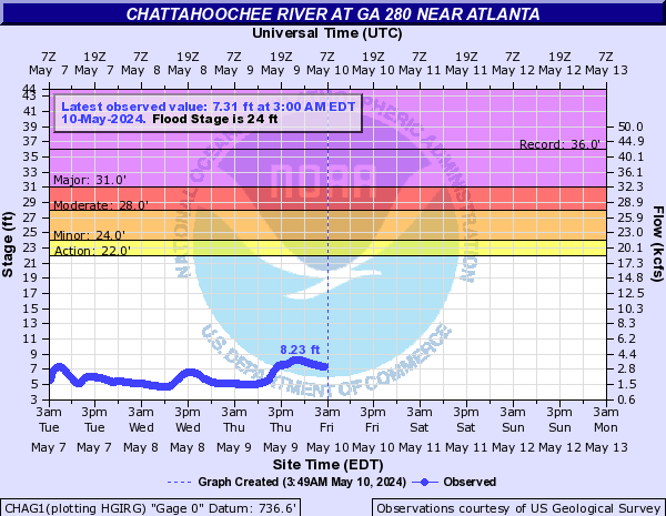
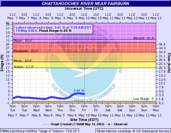
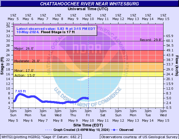
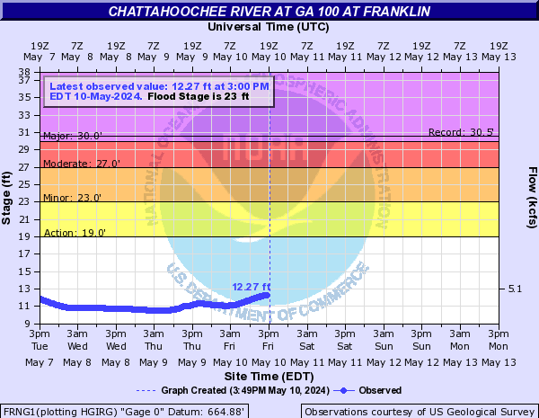
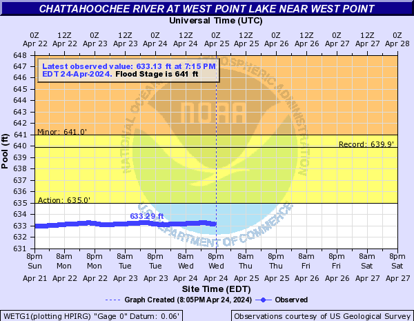
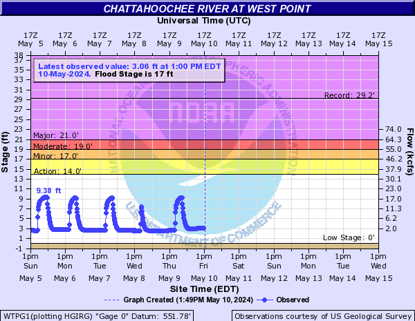
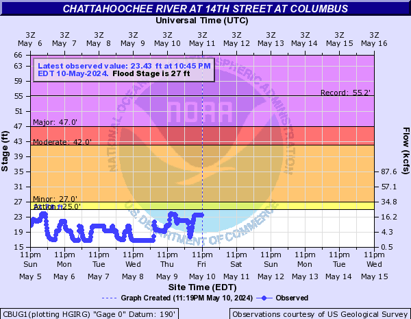
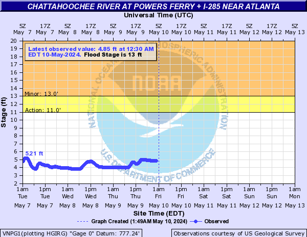
Chattahoochee River (Click on an image to go to hydrograph webpage)
HDCG1:

FOGG1:
DCNG1:
COLA1:
FPHA1:
CMMG1:
BUFG1:
WSWG1:
NCRG1:
RWLG1:
MGFG1:

VIXG1:
VING1:
CHAG1:
FBNG1:
WHTG1:
FRNG1:
WETG1:
WTPG1:
CBUG1:
VNPG1:
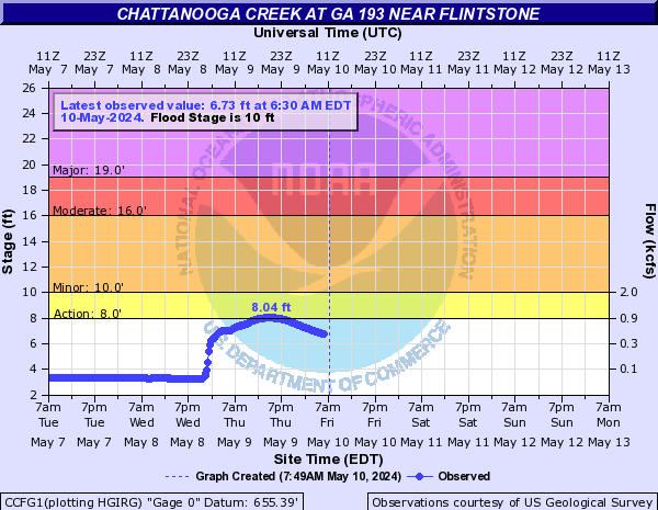
Chattanooga Creek (Click on an image to go to hydrograph webpage)
CCFG1:
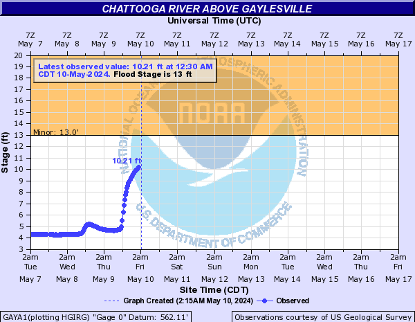
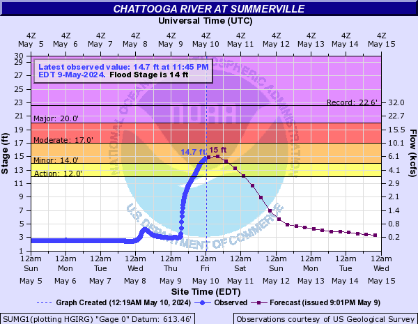
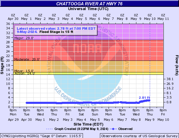
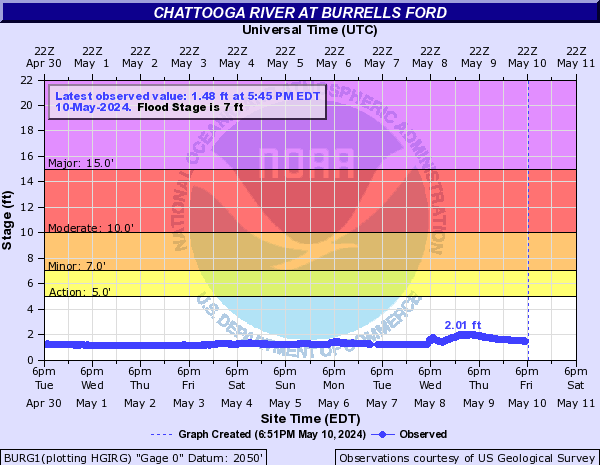
Chattooga River (Click on an image to go to hydrograph webpage)
GAYA1:
SUMG1:
CYNG1:
BURG1:
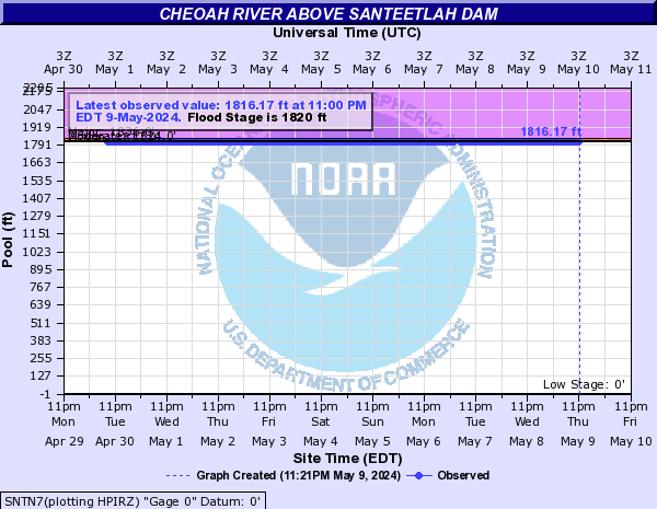
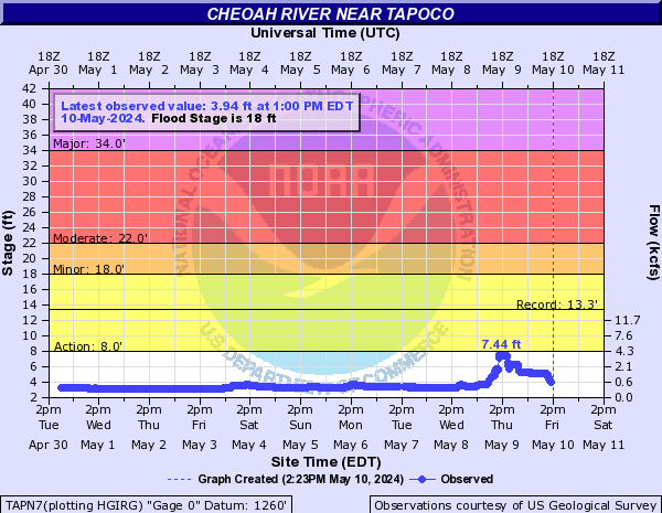
Cheoah river (Click on an image to go to hydrograph webpage)
SNTN7:
TAPN7:
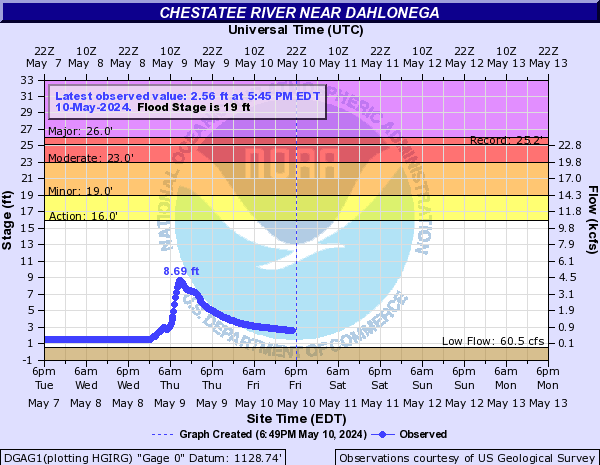
Chestatee River (Click on an image to go to hydrograph webpage)
DGAG1:
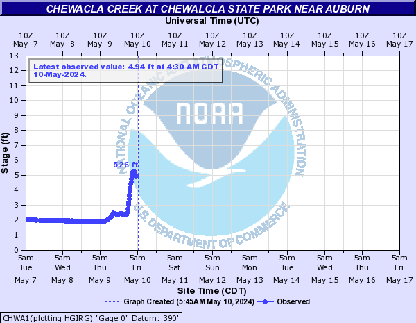
Chewacla Creek (Click on an image to go to hydrograph webpage)
CHWA1:
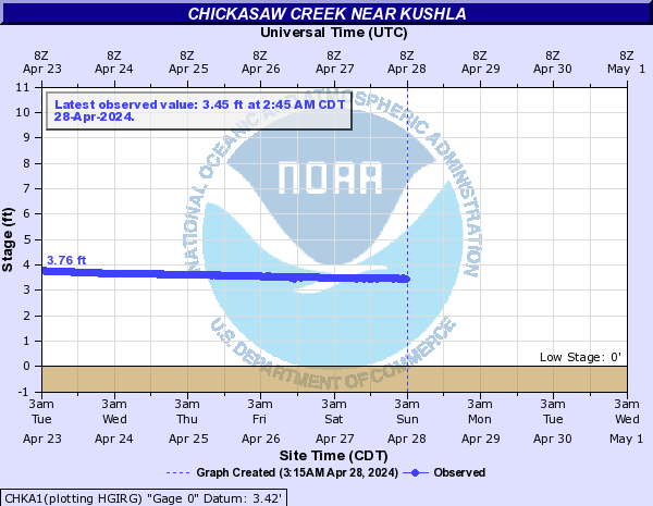
Chickasaw Creek (Click on an image to go to hydrograph webpage)
CHKA1:
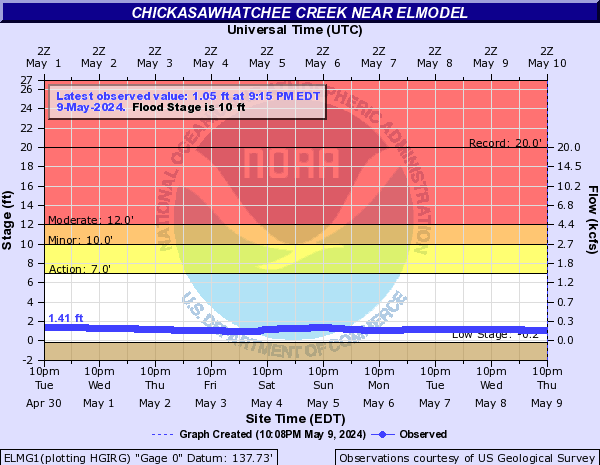
Chickasawhatchee Creek (Click on an image to go to hydrograph webpage)
ELMG1:
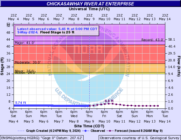
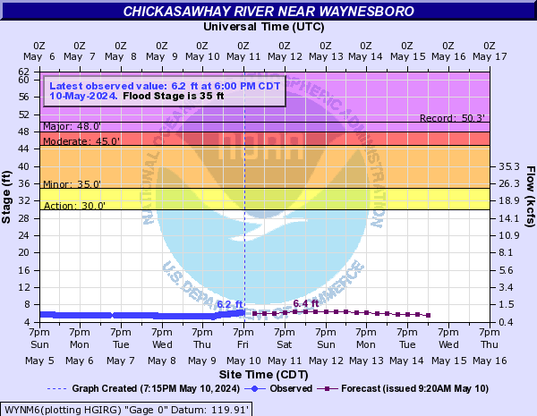
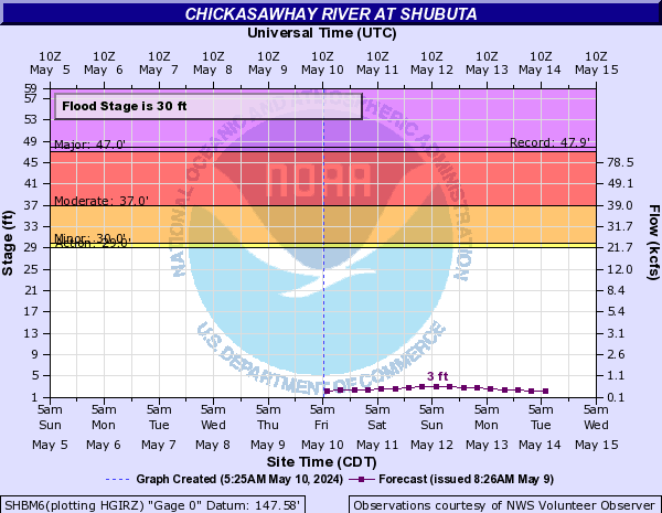
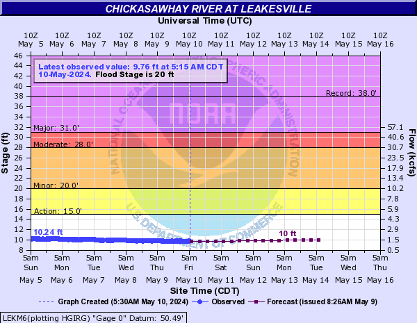
Chickasawhay River (Click on an image to go to hydrograph webpage)
ENSM6:
WYNM6:
SHBM6:
LEKM6:
QTMM6:

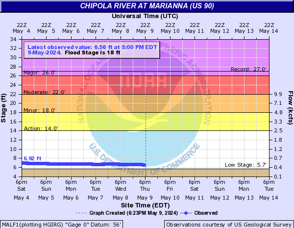
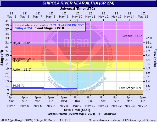
Chipola River (Click on an image to go to hydrograph webpage)
MALF1:
ALTF1:
SCTF1:

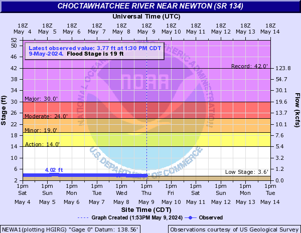
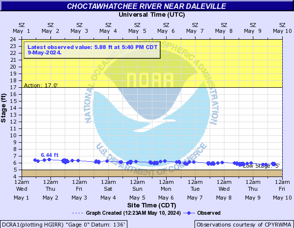
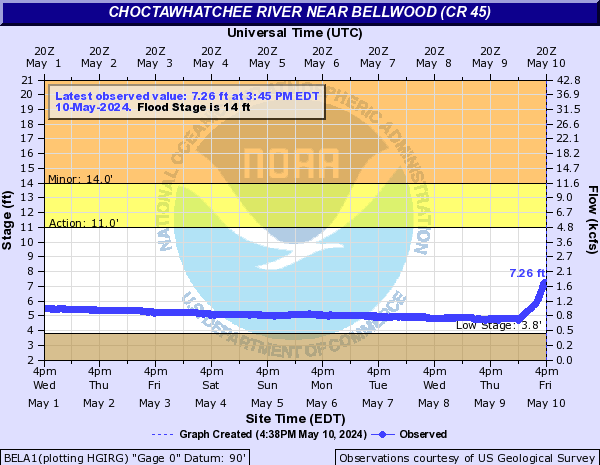
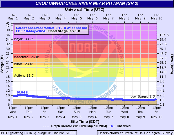
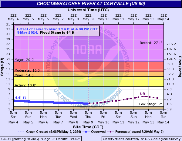
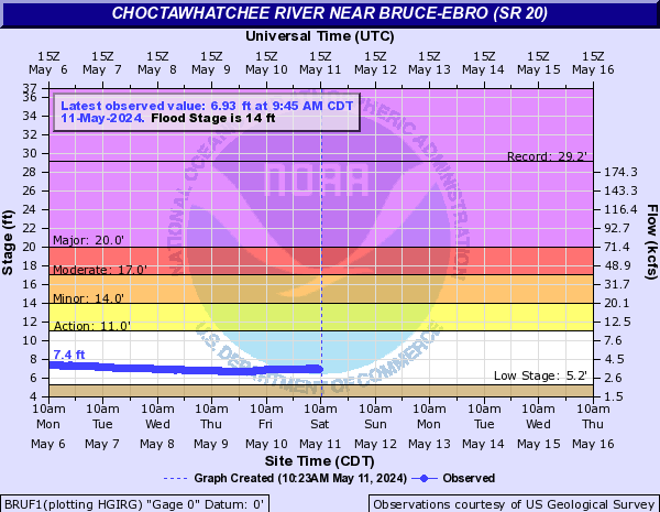
Choctawhatchee River (Click on an image to go to hydrograph webpage)
TEXA1:

NEWA1:
DCRA1:
BELA1:
GNVA1:

PITF1:
CARF1:
BRUF1:
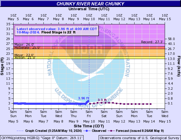
Chunky River (Click on an image to go to hydrograph webpage)
CKYM6:
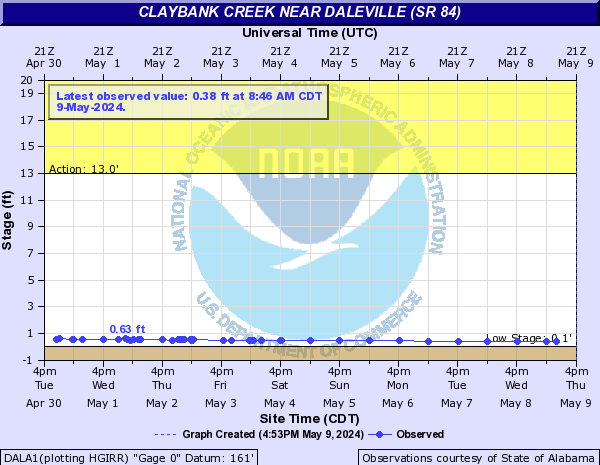
Claybank Creek (Click on an image to go to hydrograph webpage)
DALA1:
Cloud Creek (Click on an image to go to hydrograph webpage)
WMPG1:

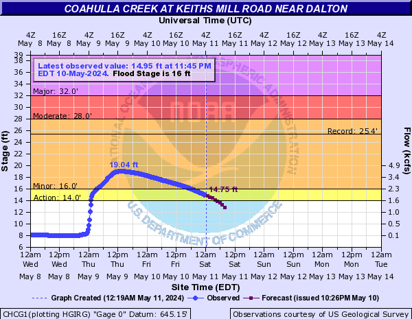
Coahulla Creek (Click on an image to go to hydrograph webpage)
CHCG1:
Cobbs Creek (Click on an image to go to hydrograph webpage)
COBG1:

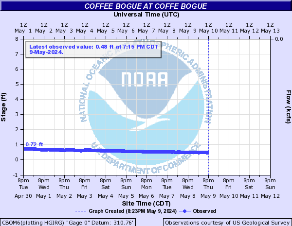
Coffee Bogue (Click on an image to go to hydrograph webpage)
CBOM6:
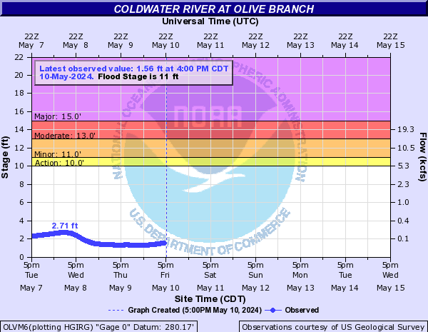
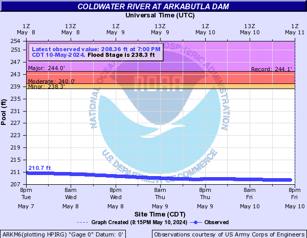
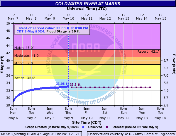
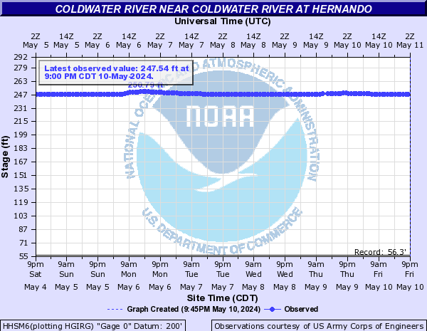
Coldwater River (Click on an image to go to hydrograph webpage)
OLVM6:
ARKM6:
SARM6:

MKSM6:
HHSM6:
Collins River (Click on an image to go to hydrograph webpage)
MCGT1:

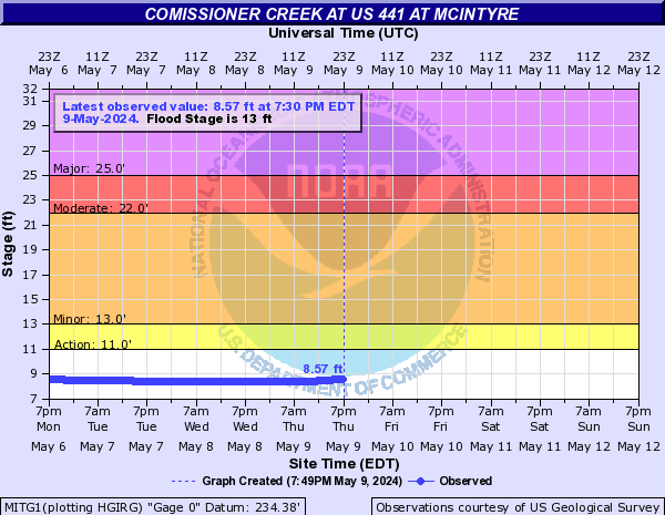
Comissioner Creek (Click on an image to go to hydrograph webpage)
MITG1:
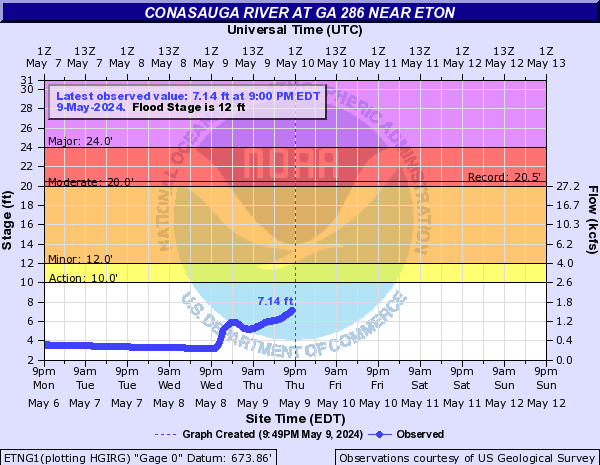
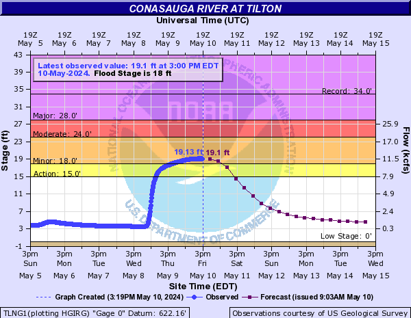
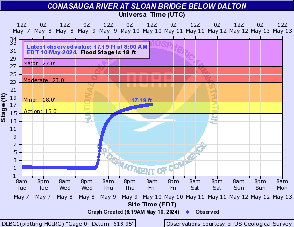
Conasauga River (Click on an image to go to hydrograph webpage)
ETNG1:
TLNG1:
DLBG1:
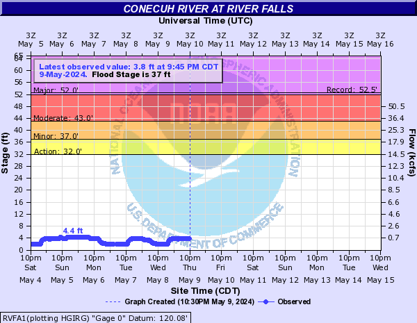
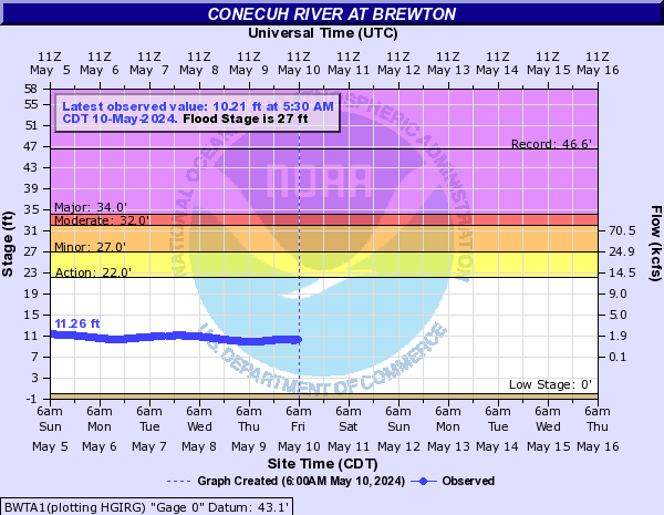
Conecuh River (Click on an image to go to hydrograph webpage)
RVFA1:
BWTA1:
BRNA1:

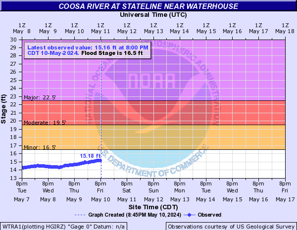
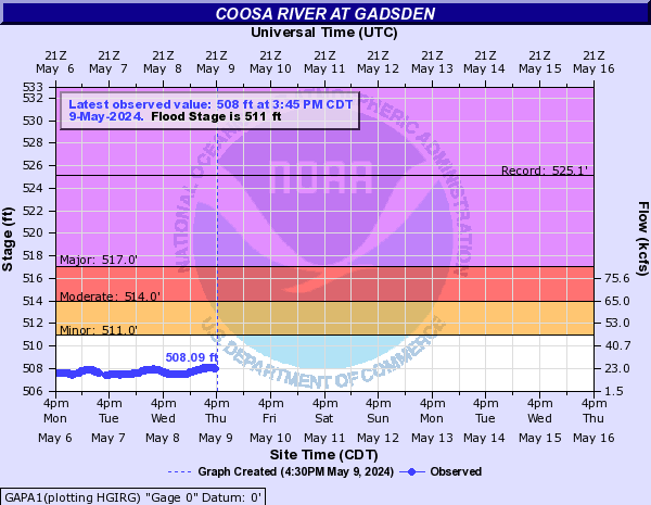
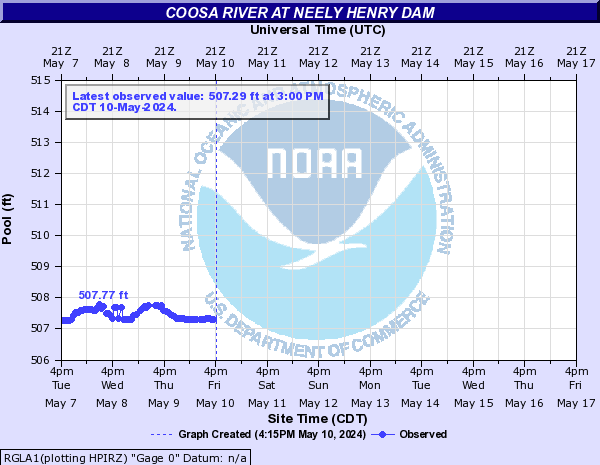
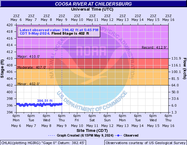
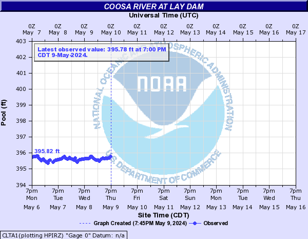
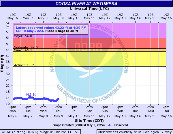
Coosa River (Click on an image to go to hydrograph webpage)
WTRA1:
HMMG1:
CREA1:

RMBG1:

GAPA1:
RGLA1:
CCSA1:
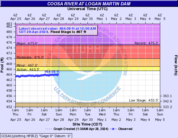
CHLA1:
CLTA1:
VRBA1:

WPKA1:

WETA1:
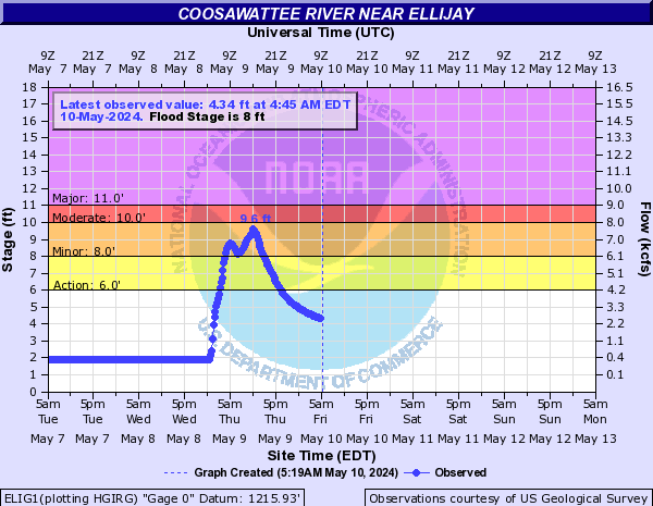
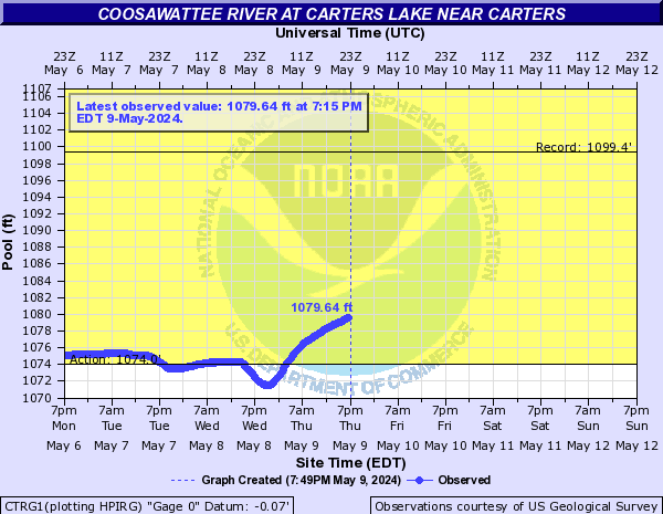
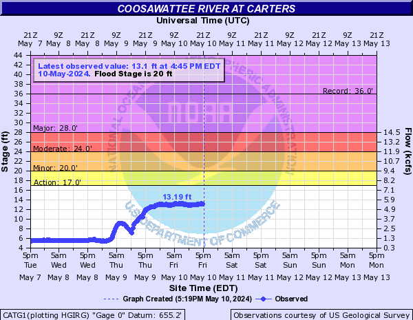
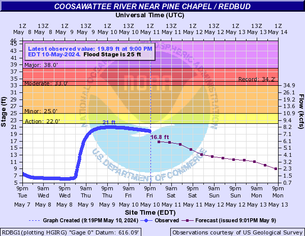
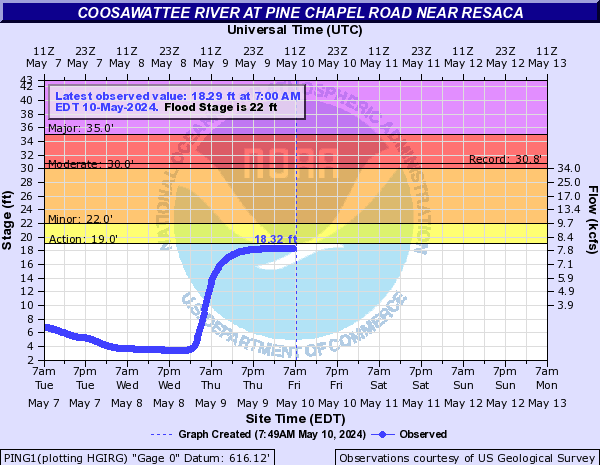
Coosawattee River (Click on an image to go to hydrograph webpage)
ELIG1:
CTRG1:
CATG1:
RDBG1:
PING1:
Cornish Creek (Click on an image to go to hydrograph webpage)
CNCG1:

CCJG1:

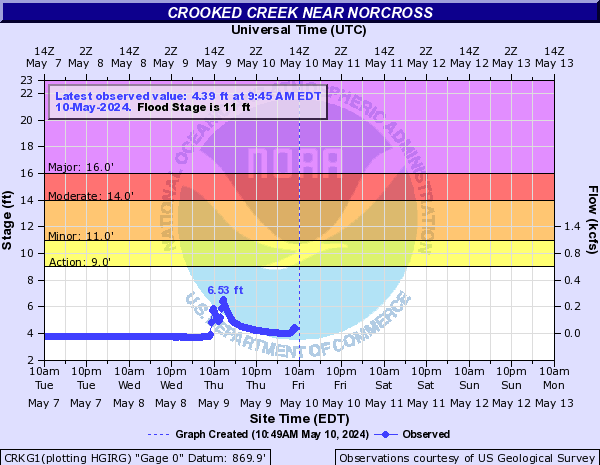
Crooked Creek (Click on an image to go to hydrograph webpage)
CRKG1:
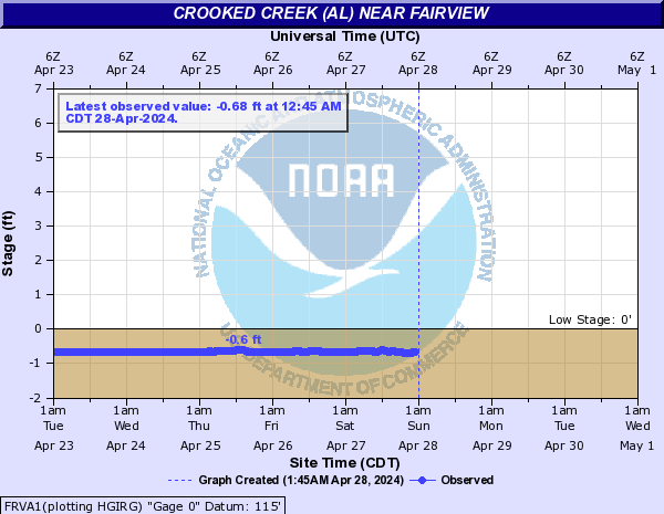
Crooked Creek (AL) (Click on an image to go to hydrograph webpage)
FRVA1:
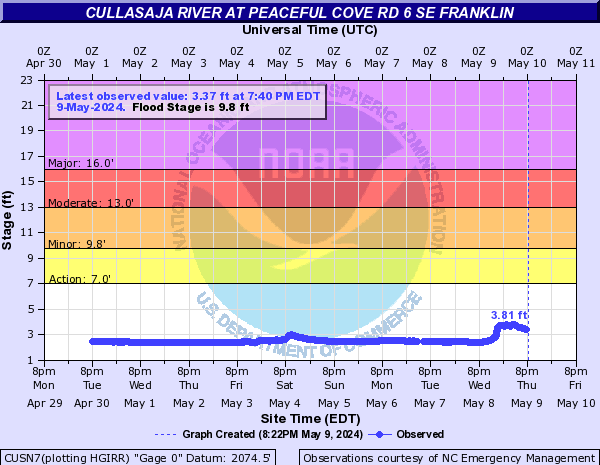
Cullowhee Creek (Click on an image to go to hydrograph webpage)
CUCN7:

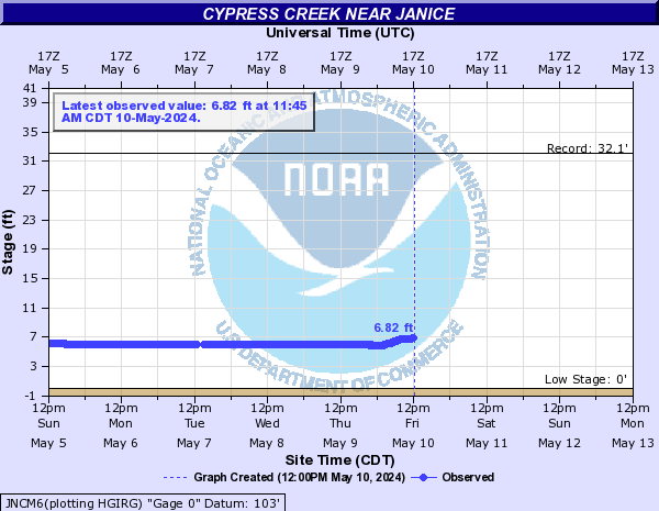
Cypress Creek (Click on an image to go to hydrograph webpage)
JNCM6:
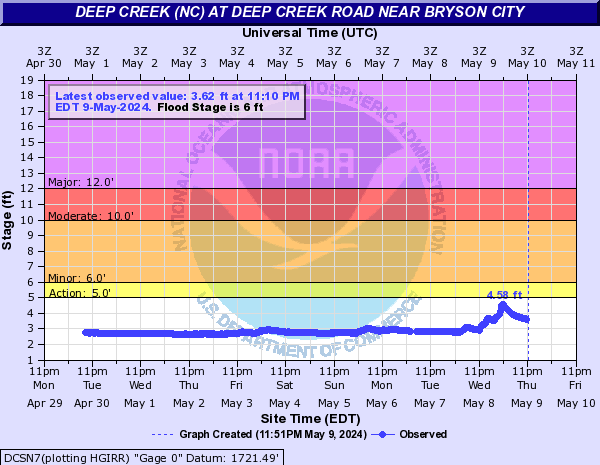
Deep Creek (NC) (Click on an image to go to hydrograph webpage)
DCSN7:
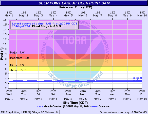
Deer Point Lake (Click on an image to go to hydrograph webpage)
DPLF1:
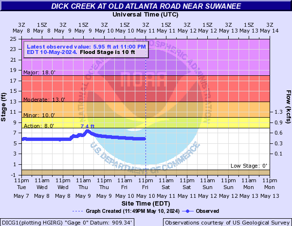
Dick Creek (Click on an image to go to hydrograph webpage)
DICG1:
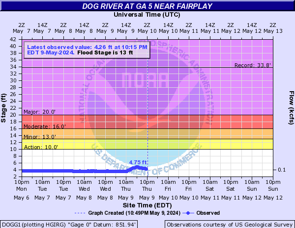
Dog River (Click on an image to go to hydrograph webpage)
DOGG1:
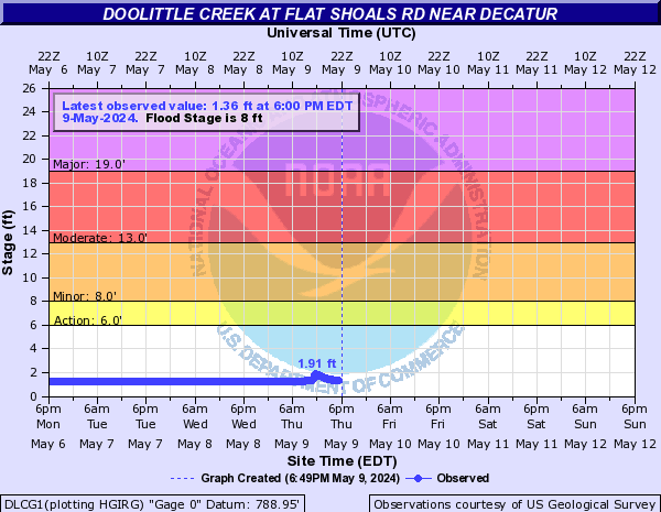
Doolittle Creek (Click on an image to go to hydrograph webpage)
DLCG1:
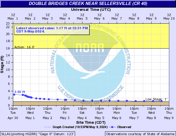
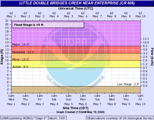
Double Bridges Creek (Click on an image to go to hydrograph webpage)
SLLA1:
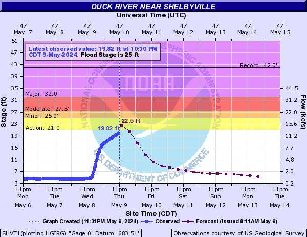
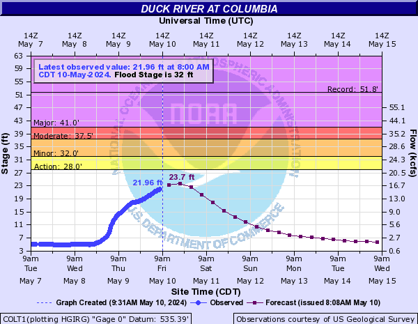
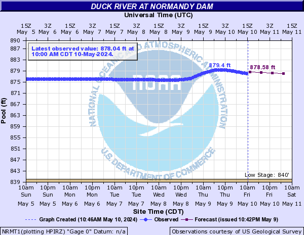
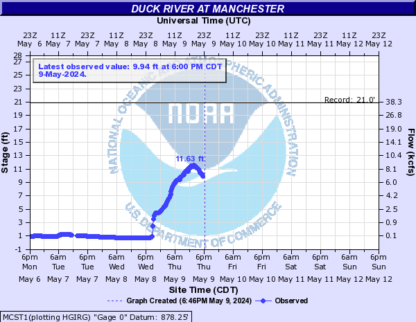
Duck River (Click on an image to go to hydrograph webpage)
SHVT1:
COLT1:
NRMT1:
MCST1:
MLTT1:

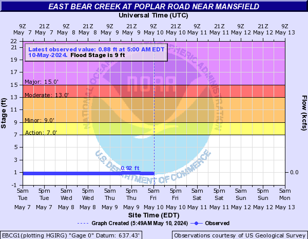
East Bear Creek (Click on an image to go to hydrograph webpage)
EBCG1:
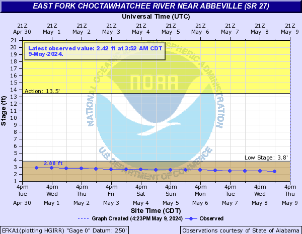
East Fork Choctawhatchee River (Click on an image to go to hydrograph webpage)
EFKA1:
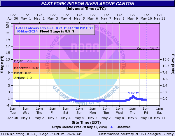
East Fork Pigeon River (Click on an image to go to hydrograph webpage)
CEPN7:
East Hobolochitto Creek (Click on an image to go to hydrograph webpage)
CREM6:

Echeconnee Creek (Click on an image to go to hydrograph webpage)
BYNG1:

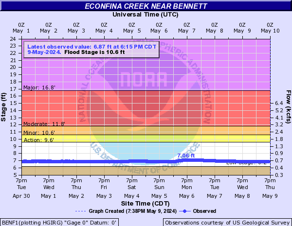
Econfina Creek (Click on an image to go to hydrograph webpage)
ECBF1:

BENF1:
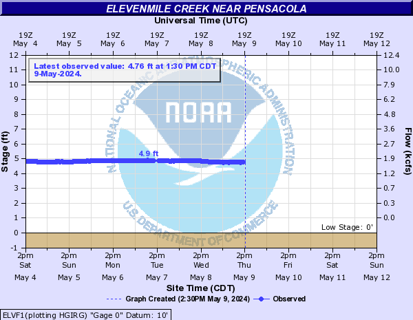
Elevenmile Creek (Click on an image to go to hydrograph webpage)
ELVF1:
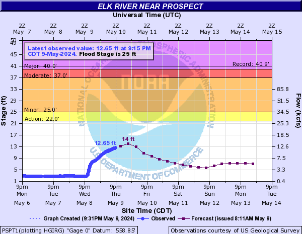
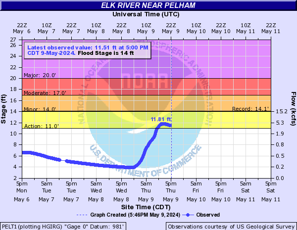
Elk River (Click on an image to go to hydrograph webpage)
PSPT1:
PELT1:
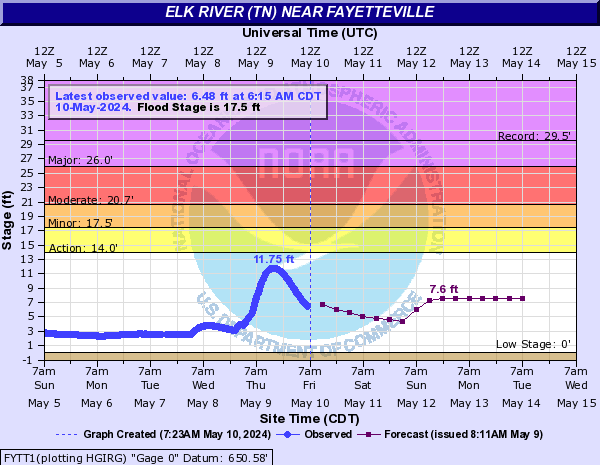
Elk River (TN) (Click on an image to go to hydrograph webpage)
FYTT1:
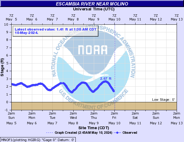
Escambia River (Click on an image to go to hydrograph webpage)
CTYF1:

MNOF1:
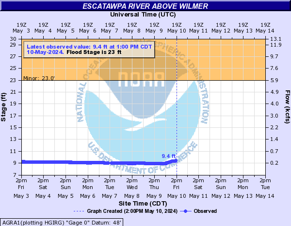
Escatawpa River (Click on an image to go to hydrograph webpage)
ORAM6:

AGRA1:
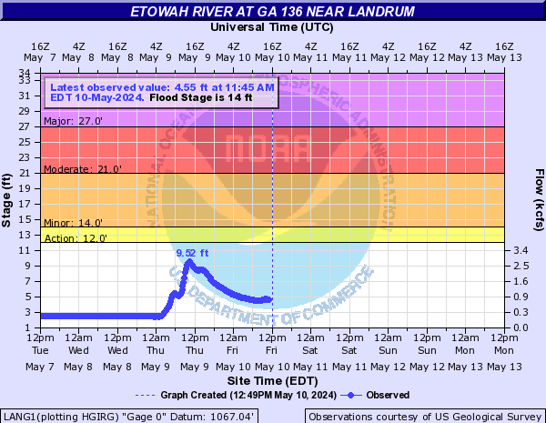
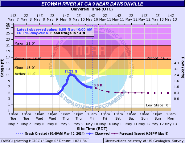
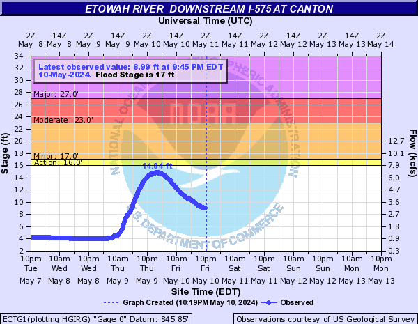
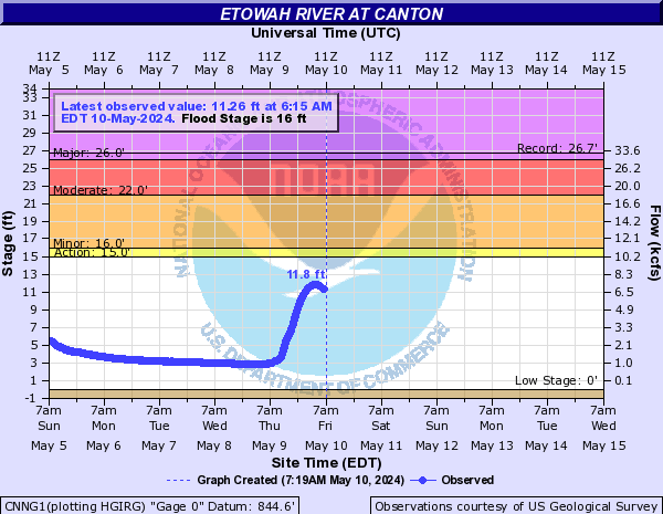
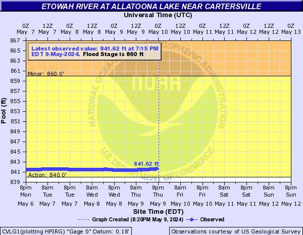
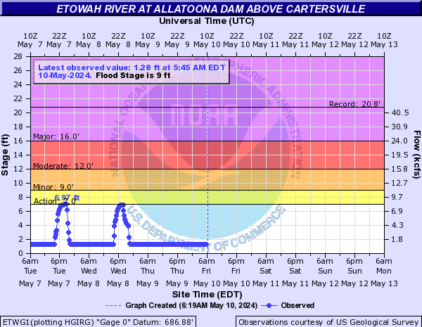
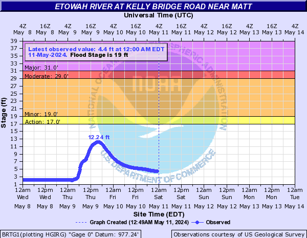
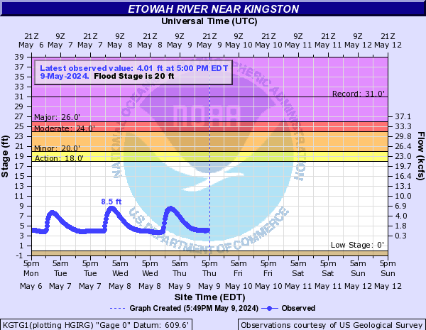
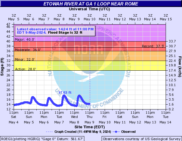
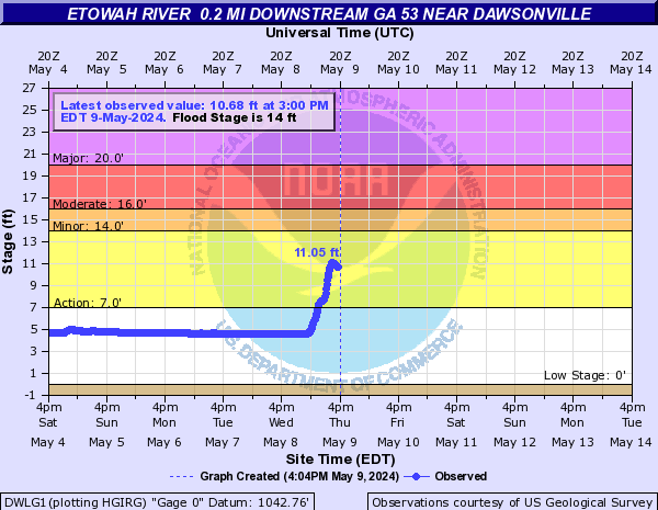
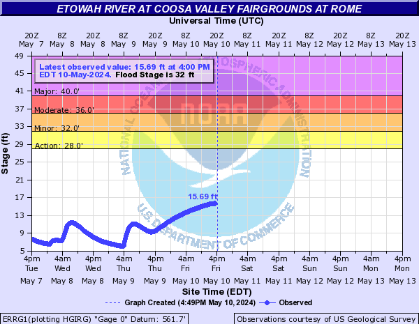
Etowah River (Click on an image to go to hydrograph webpage)
LANG1:
DWSG1:
ECTG1:
CNNG1:
CVLG1:
ETWG1:
BRTG1:
CTVG1:

KGTG1:
ROEG1:
DWLG1:
ERRG1:
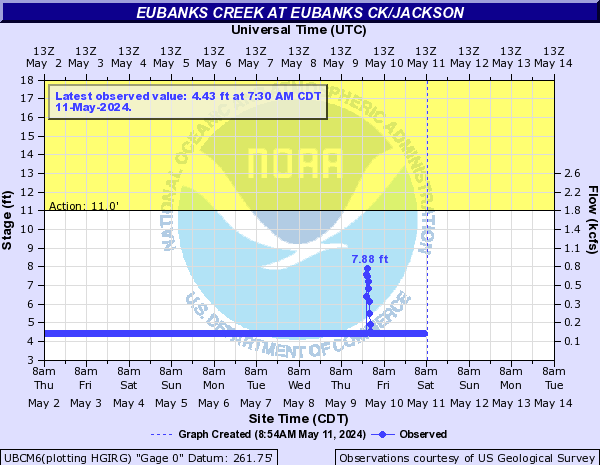
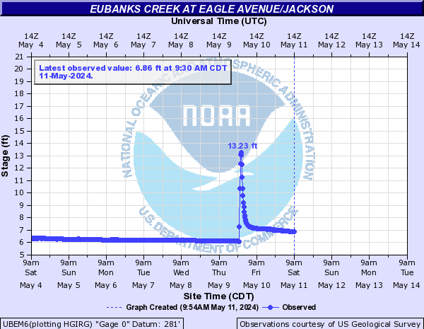
Eubanks Creek (Click on an image to go to hydrograph webpage)
UBCM6:
UBEM6:
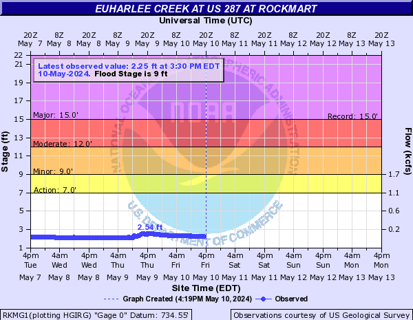
Euharlee Creek (Click on an image to go to hydrograph webpage)
RKMG1:
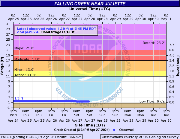
Falling Creek (Click on an image to go to hydrograph webpage)
FALG1:
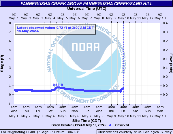
Fannegusha Creek (Click on an image to go to hydrograph webpage)
FNGM6:
Fausett Creek (Click on an image to go to hydrograph webpage)
FCTG1:

Fighting Creek (Click on an image to go to hydrograph webpage)
SGLT1:
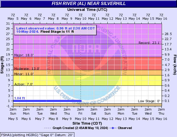
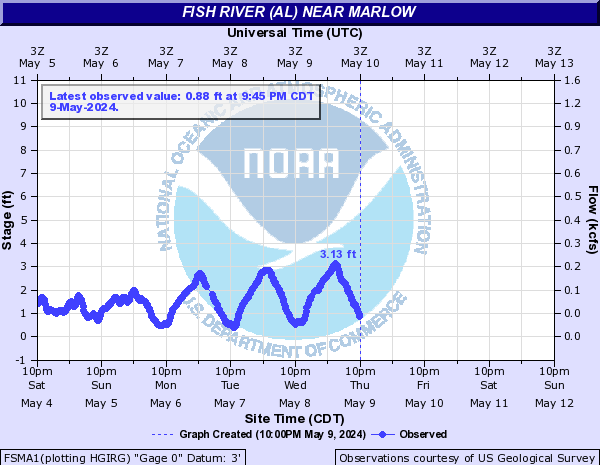
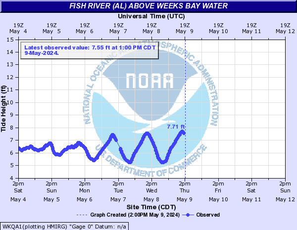
Fish River (AL) (Click on an image to go to hydrograph webpage)
FSHA1:
FSMA1:
WKQA1:
Fisher Creek (Click on an image to go to hydrograph webpage)
SPHF1:

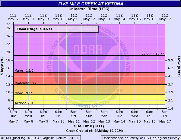
Five Mile Creek (Click on an image to go to hydrograph webpage)
KETA1:
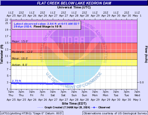
Flat Creek (Click on an image to go to hydrograph webpage)
LKTG1:
LPTG1:

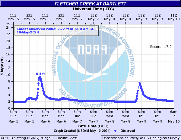
Fletcher Creek (Click on an image to go to hydrograph webpage)
MPHT1:
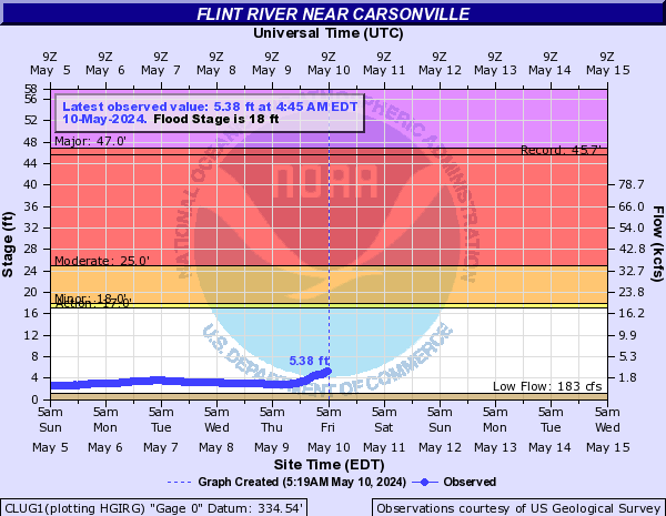
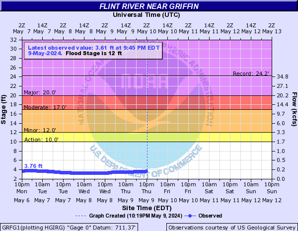
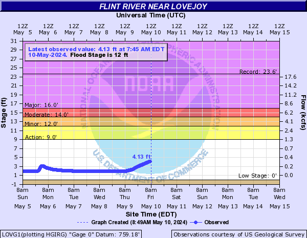
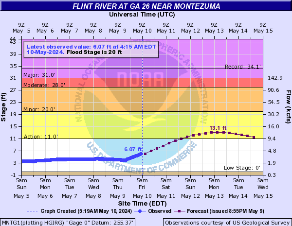
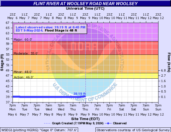
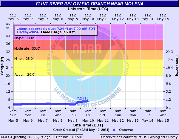
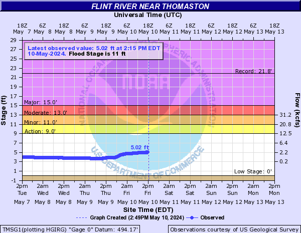
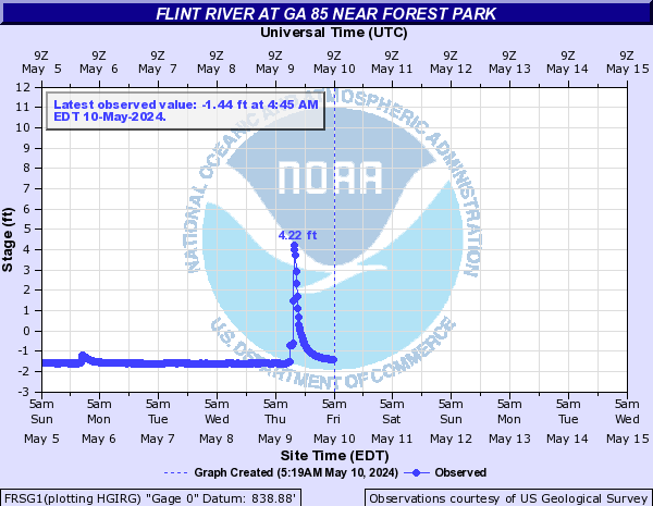
Flint River (Click on an image to go to hydrograph webpage)
CLUG1:
GRFG1:
LOVG1:
MNTG1:
WSEG1:
MOLG1:
TMSG1:
FRSG1:
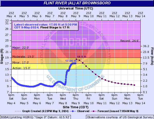
Flint River (AL) (Click on an image to go to hydrograph webpage)
BSBA1:
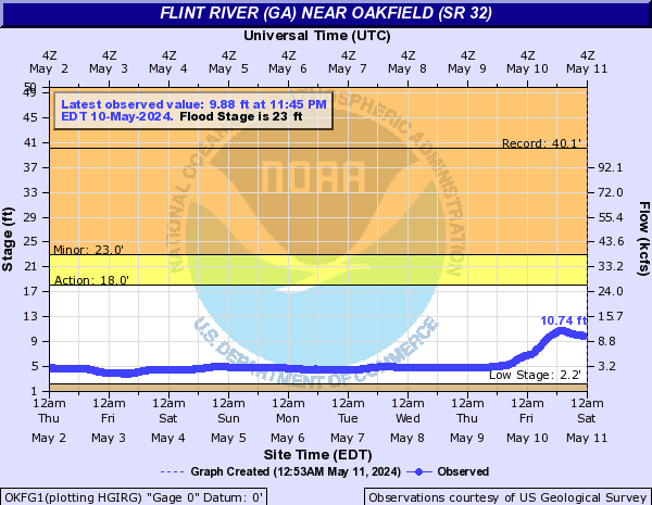
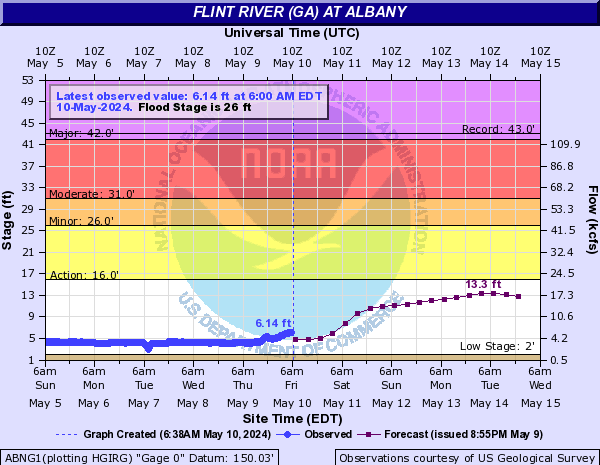
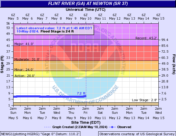
Flint River (GA) (Click on an image to go to hydrograph webpage)
WWCG1:

OKFG1:
ABNG1:
NEWG1:
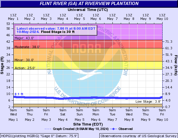
HOPG1:
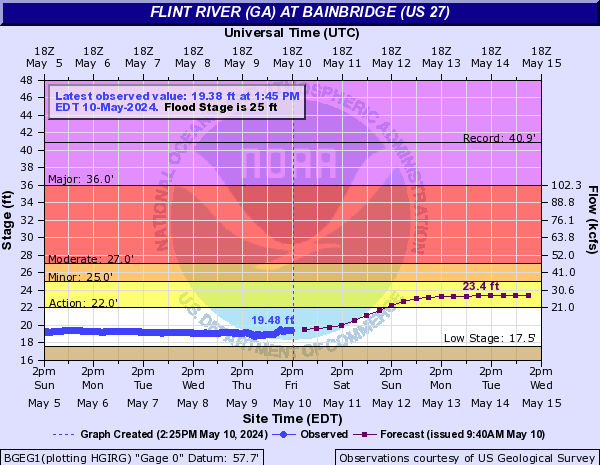
BGEG1:
Fowl River (Click on an image to go to hydrograph webpage)
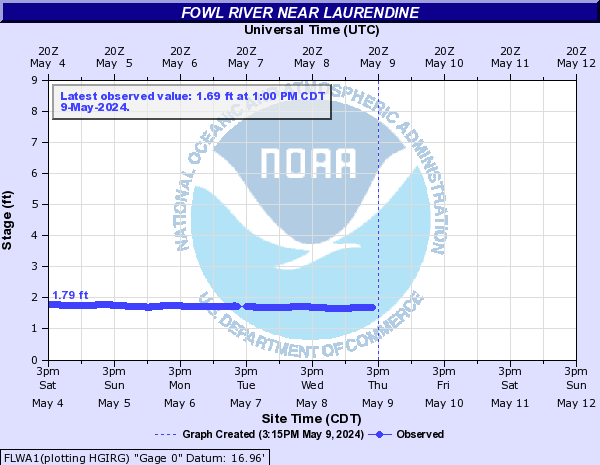
FLWA1:
French Branch (Click on an image to go to hydrograph webpage)
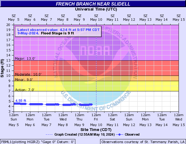
FBML1:
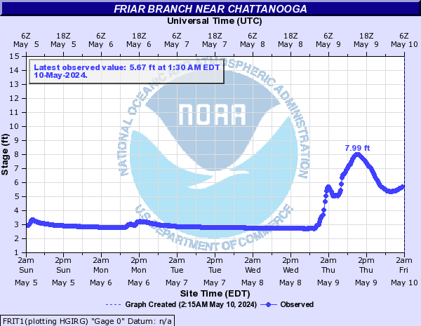
Friar Branch (Click on an image to go to hydrograph webpage)
FRIT1:
Garner Creek (Click on an image to go to hydrograph webpage)
GARG1:

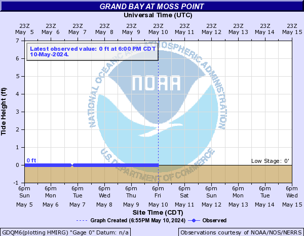
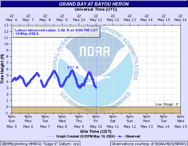
Grand Bay (Click on an image to go to hydrograph webpage)
GDQM6:
GBHM6:
GBRM6:

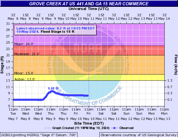
Grove Creek (Click on an image to go to hydrograph webpage)
GCBG1:
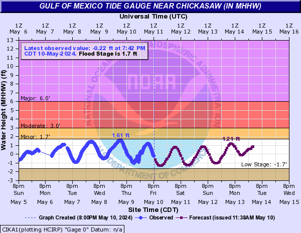
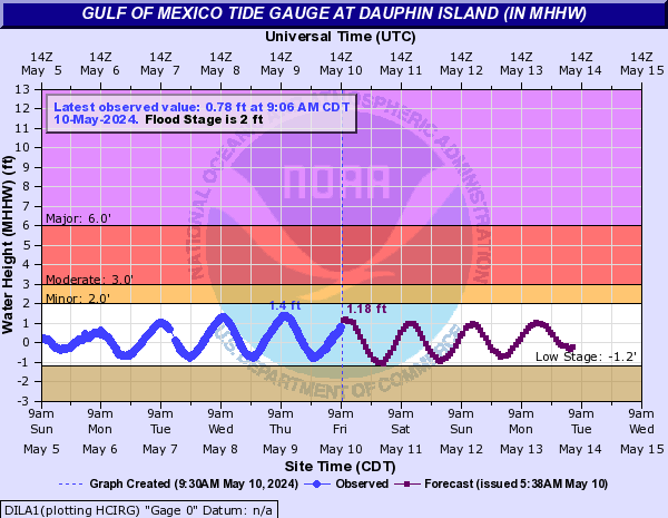
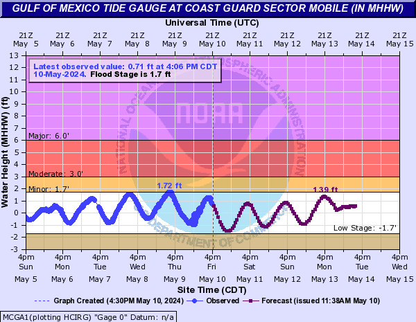
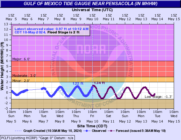
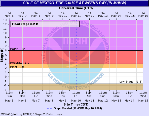
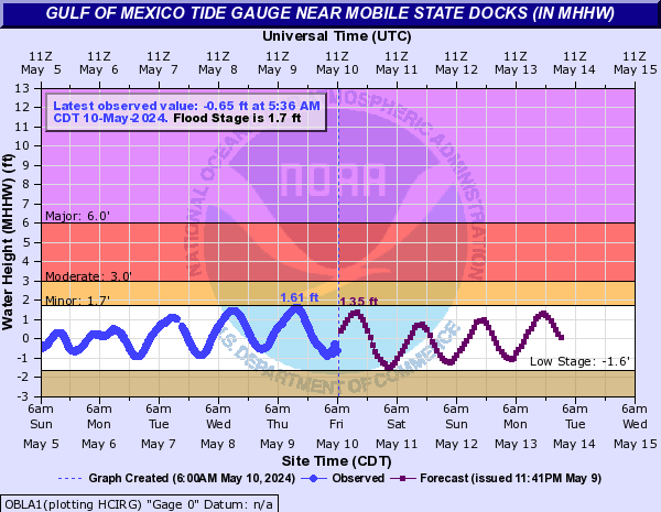
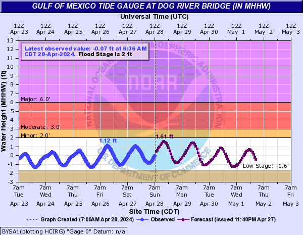
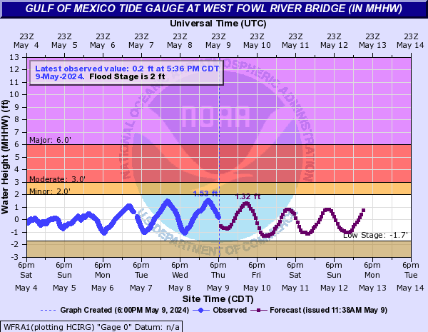
Gulf of Mexico Tide Gauge (Click on an image to go to hydrograph webpage)
BLBA1:

CIKA1:
DILA1:
EFRA1:

MCGA1:
PCLF1:
WBYA1:
OBLA1:
BYSA1:
WFRA1:
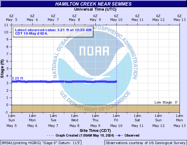
Hamilton Creek (Click on an image to go to hydrograph webpage)
SMSA1:
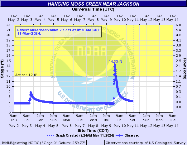
Hanging Moss Creek (Click on an image to go to hydrograph webpage)
JHMM6:
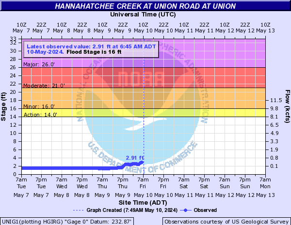
Hannahatchee Creek (Click on an image to go to hydrograph webpage)
UNIG1:
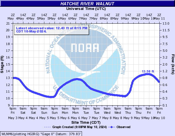
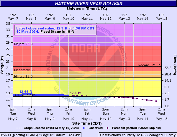
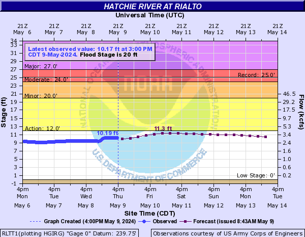
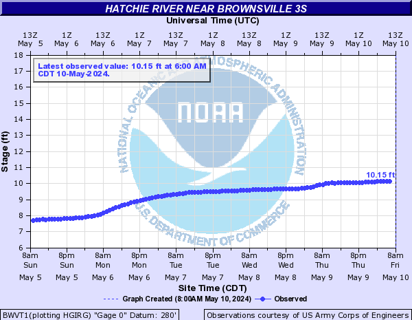
Hatchie River (Click on an image to go to hydrograph webpage)
WLNM6:
BVRT1:
RLTT1:
BWVT1:
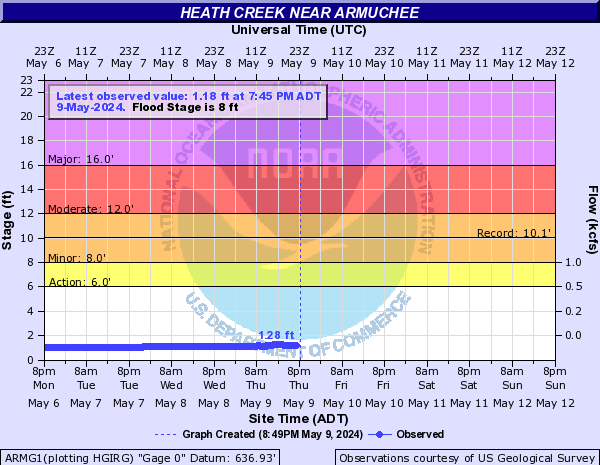
Heath Creek (Click on an image to go to hydrograph webpage)
ARMG1:
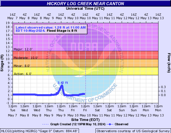
Hickory Log Creek (Click on an image to go to hydrograph webpage)
HLCG1:
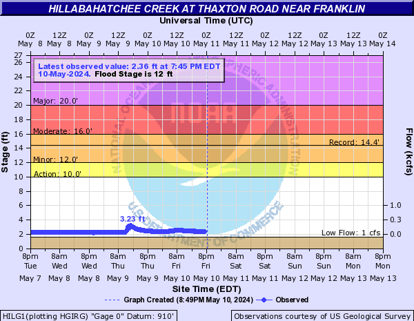
Hillabahatchee Creek (Click on an image to go to hydrograph webpage)
HILG1:
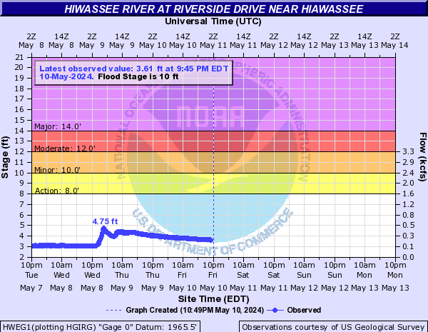
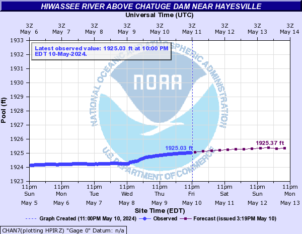
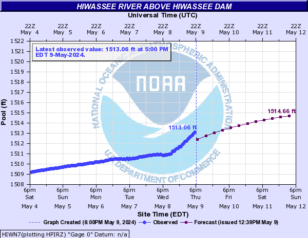
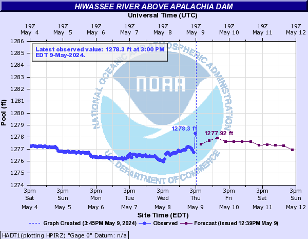
Hiwassee River (Click on an image to go to hydrograph webpage)
HWEG1:
CHAN7:
PSYG1:

CHLT1:

HIWN7:
HADT1:
MSSN7:

HYVN7:
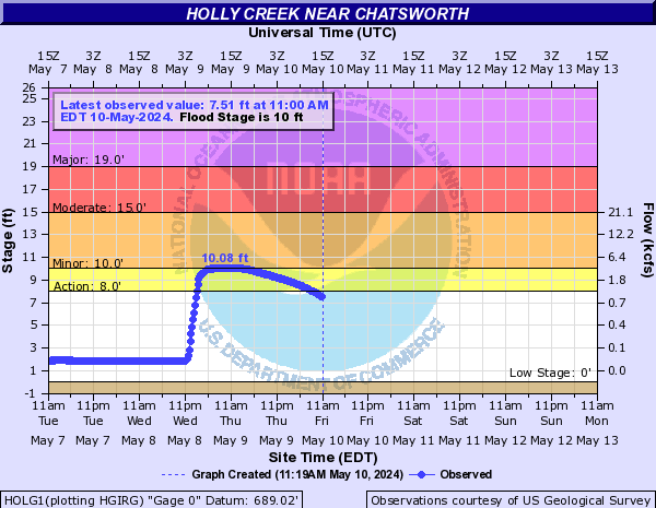
Holly Creek (Click on an image to go to hydrograph webpage)
HOLG1:
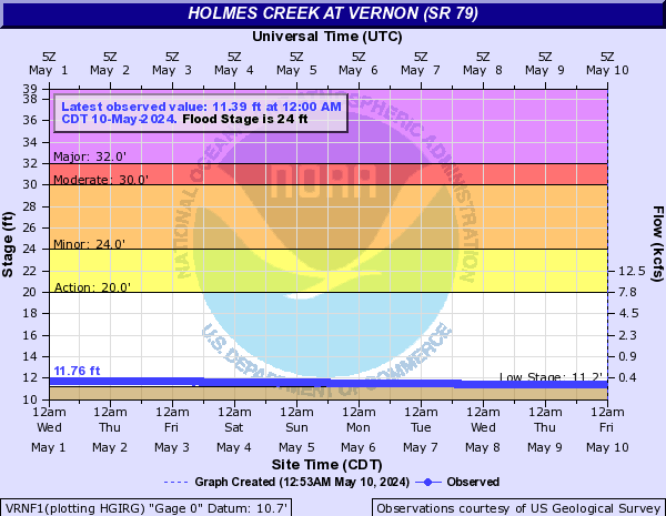
Holmes Creek (Click on an image to go to hydrograph webpage)
VRNF1:
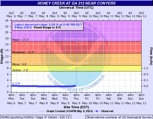
Honey Creek (Click on an image to go to hydrograph webpage)
HONG1:
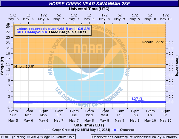
Horse Creek (Click on an image to go to hydrograph webpage)
HORT1:
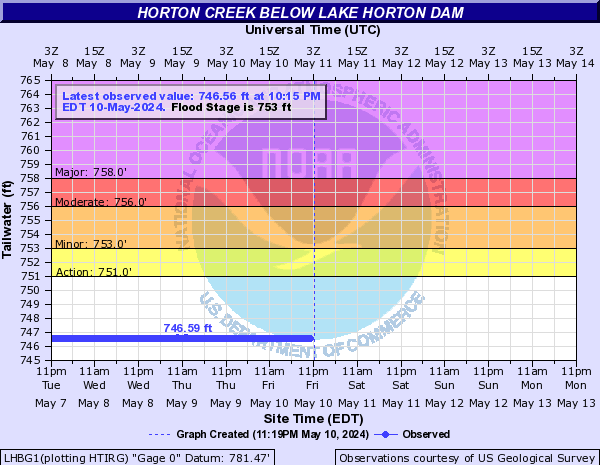
Horton Creek (Click on an image to go to hydrograph webpage)
LHBG1:
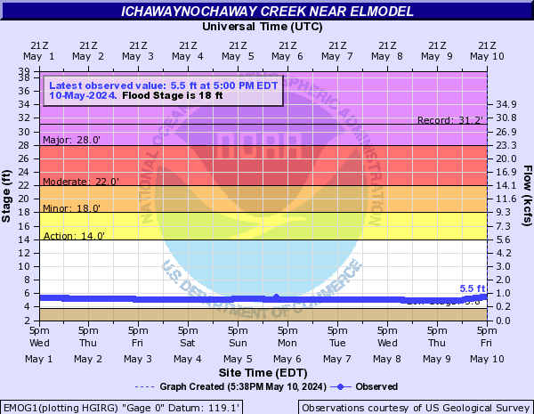
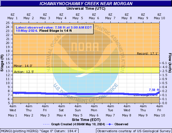
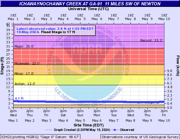
Ichawaynochaway Creek (Click on an image to go to hydrograph webpage)
MLFG1:

EMOG1:
MGNG1:
ICHG1:
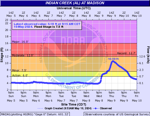
Indian Creek (AL) (Click on an image to go to hydrograph webpage)
MADA1:
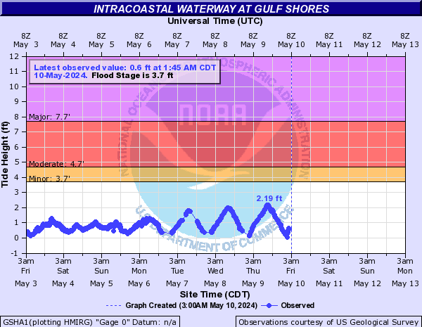
Intracoastal Waterway (Click on an image to go to hydrograph webpage)
GSHA1:
Intrenchment Creek (Click on an image to go to hydrograph webpage)
INTG1:
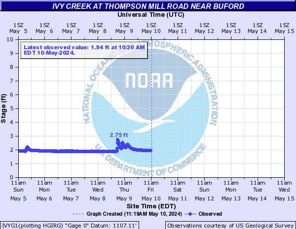
Ivy Creek (Click on an image to go to hydrograph webpage)
IVYG1:
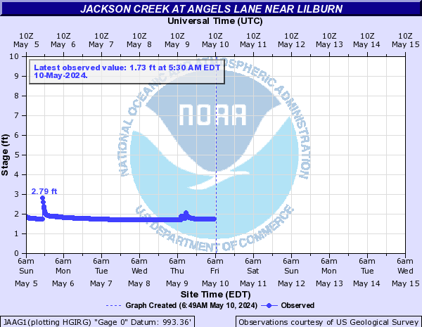
Jackson Creek (Click on an image to go to hydrograph webpage)
JAAG1:
Jackson Creek Tributary (Click on an image to go to hydrograph webpage)
JAWG1:

Jonathan Creek (Click on an image to go to hydrograph webpage)
MGYN7:

Jourdan River (Click on an image to go to hydrograph webpage)
KLNM6:

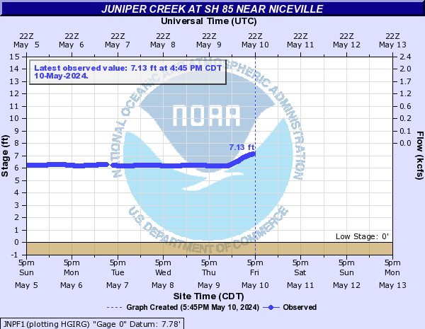
Juniper Creek (Click on an image to go to hydrograph webpage)
JNPF1:
Kettle Creek (Click on an image to go to hydrograph webpage)
KETG1:

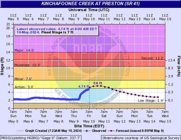
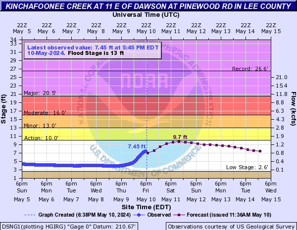
Kinchafoonee Creek (Click on an image to go to hydrograph webpage)
PRSG1:
DSNG1:
KCCG1:

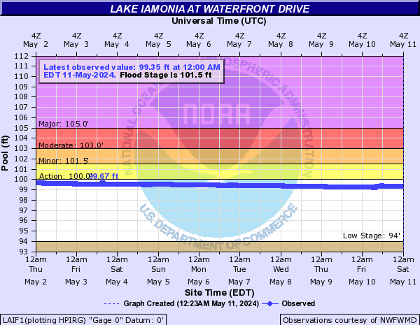
Lake Iamonia (Click on an image to go to hydrograph webpage)
LAIF1:
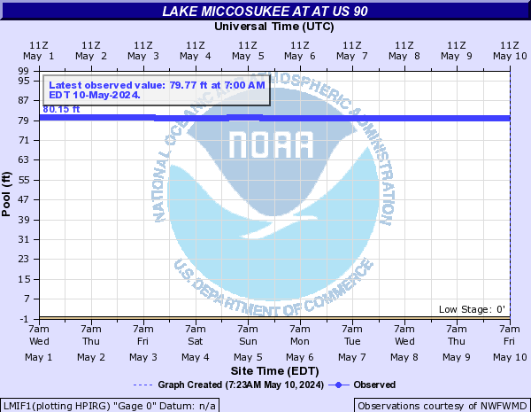
Lake Miccosukee (Click on an image to go to hydrograph webpage)
LMIF1:
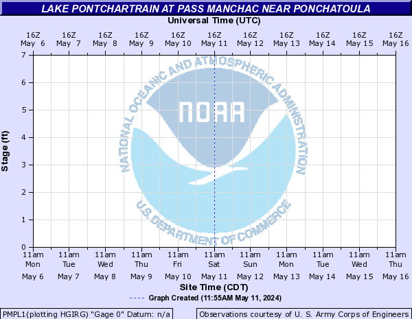
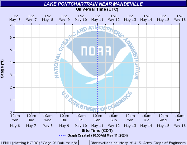
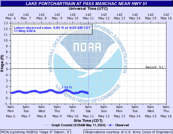
Lake Pontchartrain (Click on an image to go to hydrograph webpage)
PMPL1:
LPML1:
MCHL1:
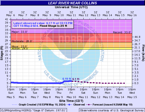
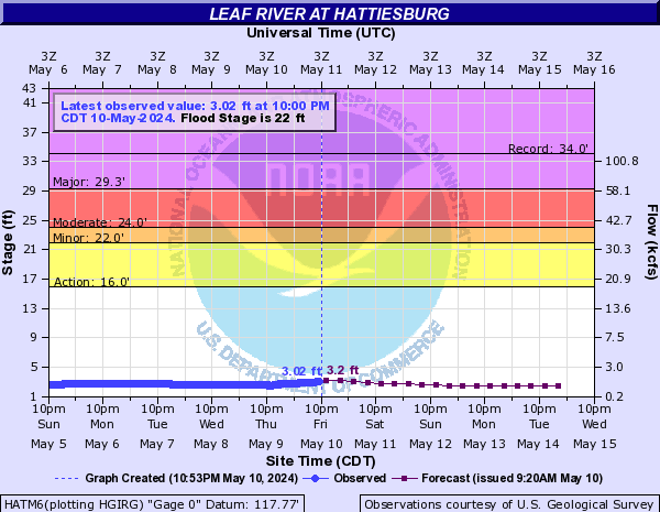
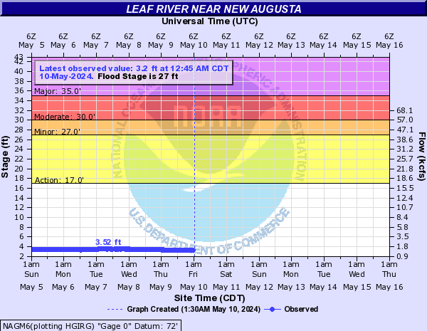
Leaf River (Click on an image to go to hydrograph webpage)
MCLM6:

CLSM6:
HATM6:
NAGM6:
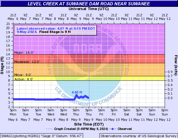
Level Creek (Click on an image to go to hydrograph webpage)
SWAG1:
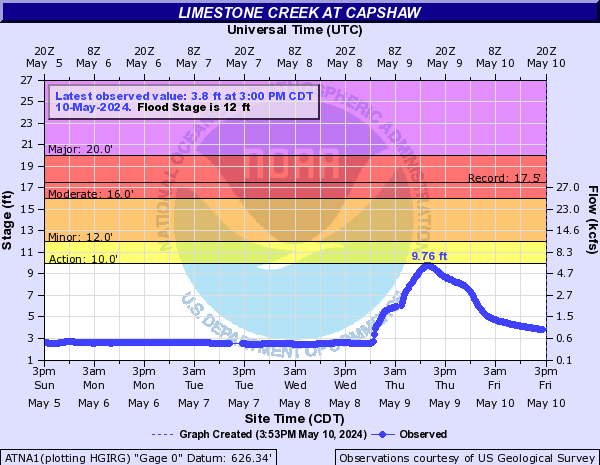
Limestone Creek (AL) (Click on an image to go to hydrograph webpage)
ATNA1:
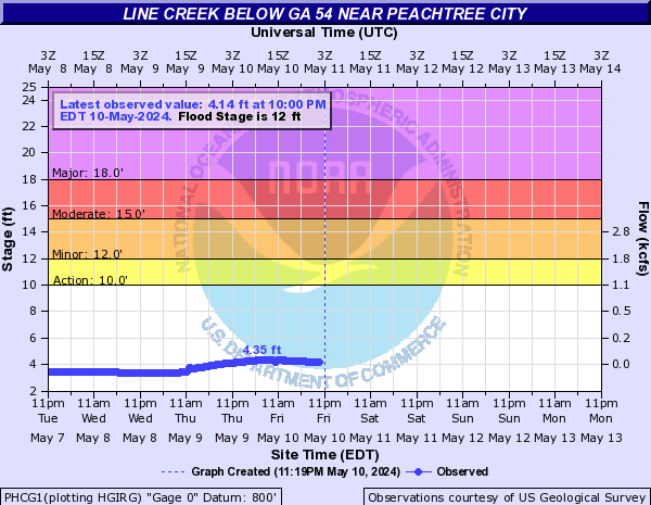
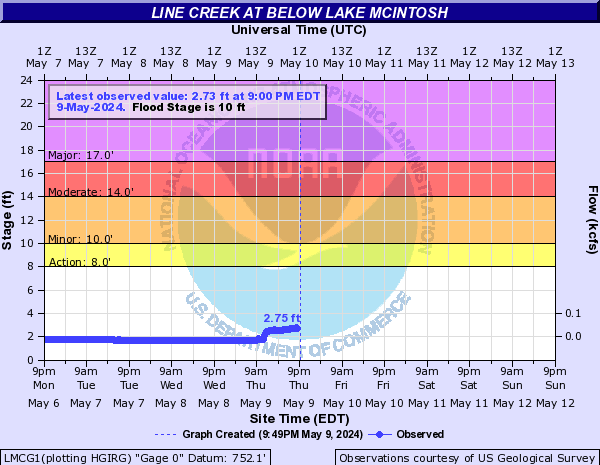
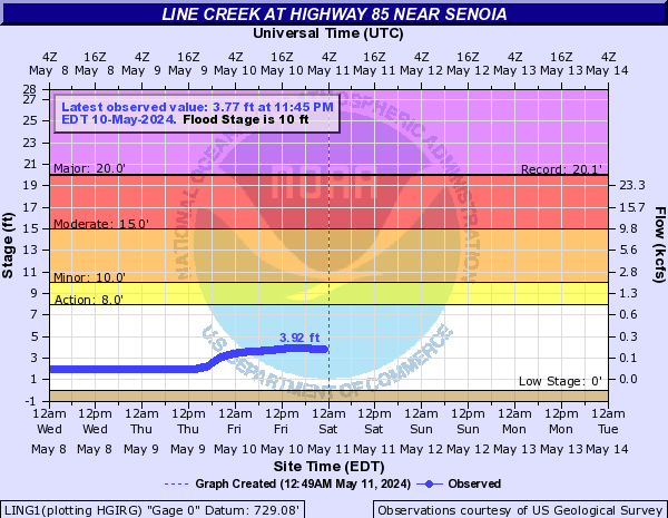
Line Creek (Click on an image to go to hydrograph webpage)
PHCG1:
LMCG1:
LING1:
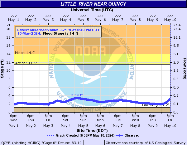
Little River (Click on an image to go to hydrograph webpage)
QCYF1:
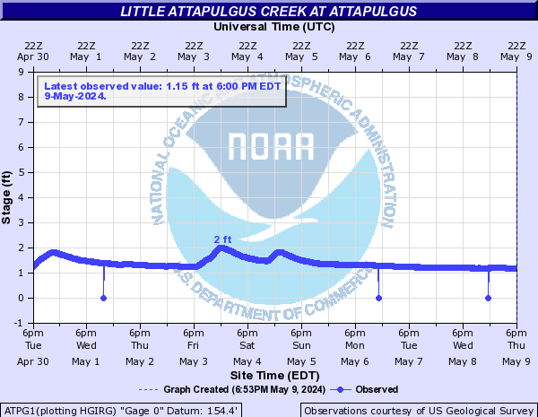
Little Attapulgus Creek (Click on an image to go to hydrograph webpage)
ATPG1:
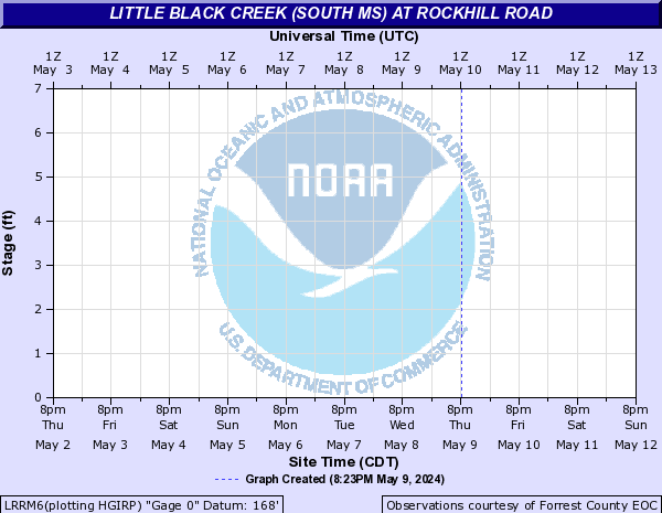
Little Black Creek (south MS) (Click on an image to go to hydrograph webpage)
LRRM6:
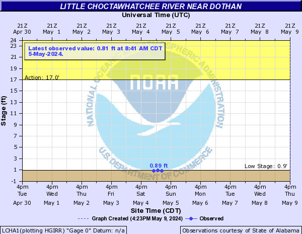
Little Choctawhatchee River (Click on an image to go to hydrograph webpage)
LCHA1:
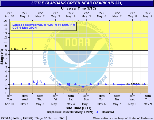
Little Claybank Creek (Click on an image to go to hydrograph webpage)
OCBA1:
Little Cornish Creek (Click on an image to go to hydrograph webpage)
LCBG1:

Little Double Bridges Creek (Click on an image to go to hydrograph webpage)
LDBA1:
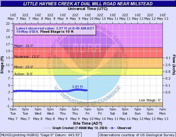
Little Haynes Creek (Click on an image to go to hydrograph webpage)
MLHG1:
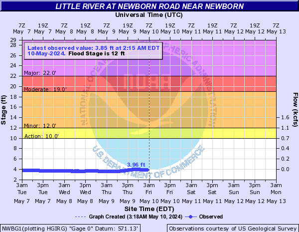
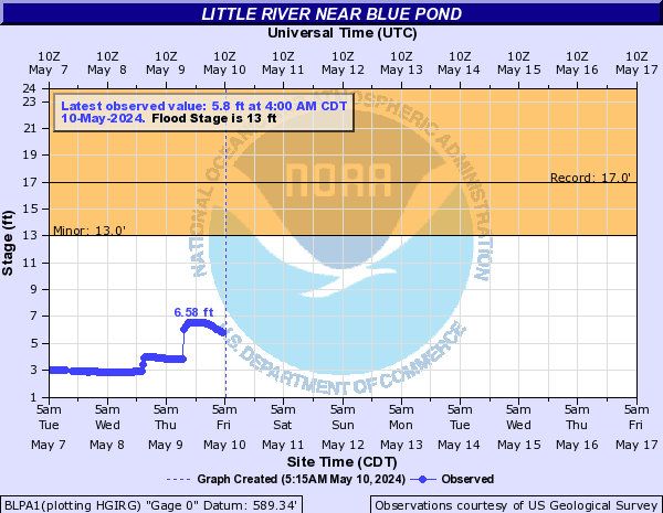
Little River (Click on an image to go to hydrograph webpage)
NWBG1:
BLPA1:
EANG1:

WODG1:

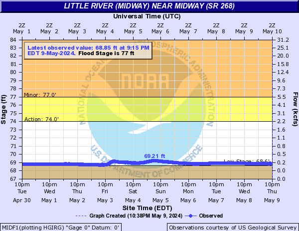
Little River (Midway) (Click on an image to go to hydrograph webpage)
MIDF1:
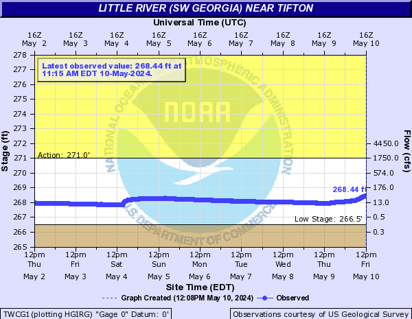
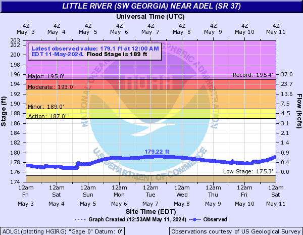
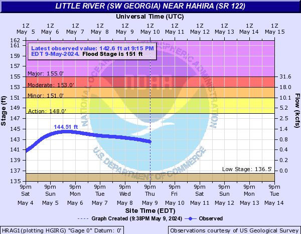
Little River (SW Georgia) (Click on an image to go to hydrograph webpage)
TWCG1:
ADLG1:
HRAG1:
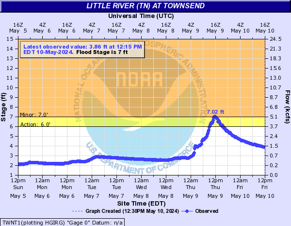
Little River (TN) (Click on an image to go to hydrograph webpage)
TWNT1:
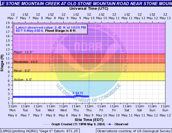
Little Stone Mountain Creek (Click on an image to go to hydrograph webpage)
LSMG1:
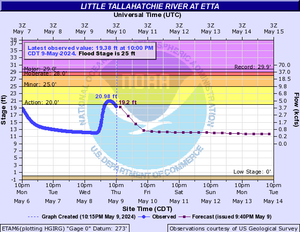
Little Tallahatchie River (Click on an image to go to hydrograph webpage)
ETAM6:
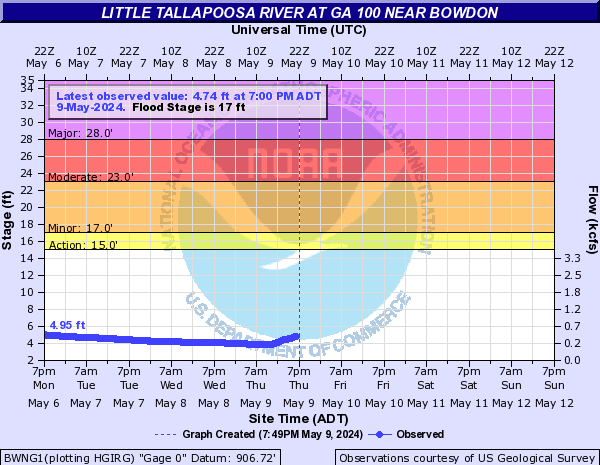
Little Tallapoosa River (Click on an image to go to hydrograph webpage)
CANG1:

BWNG1:
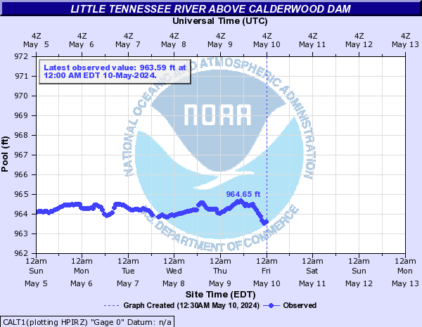
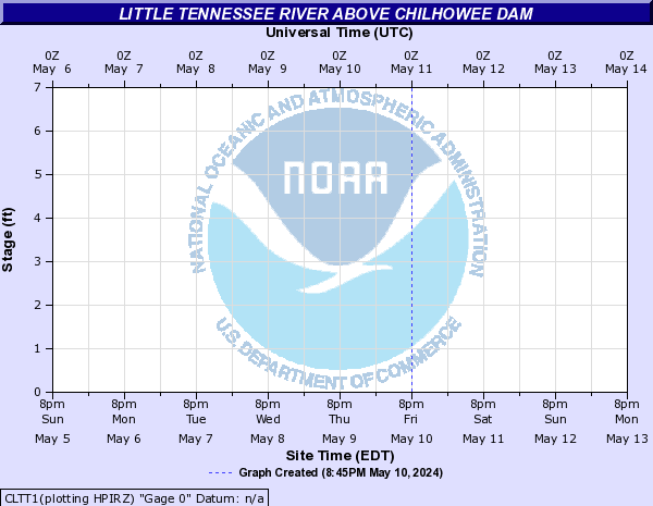
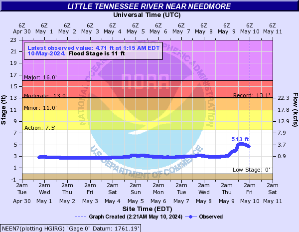
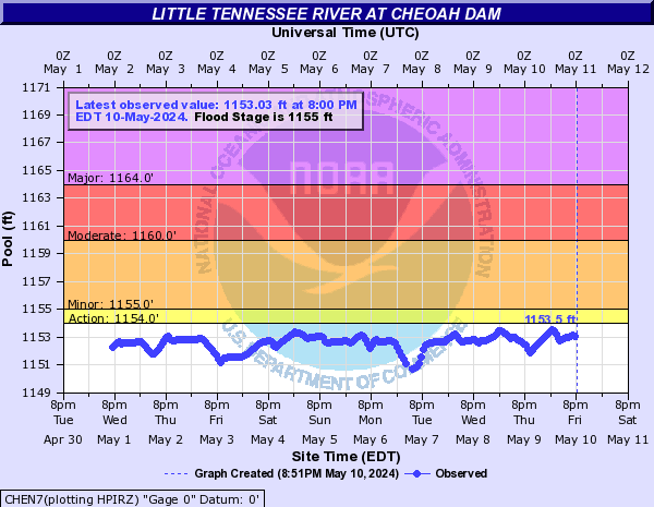
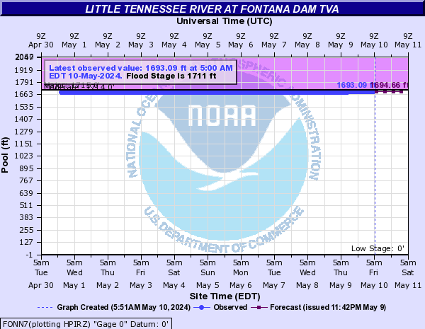
Little Tennessee River (Click on an image to go to hydrograph webpage)
CALT1:
LTIN7:

CLTT1:
NEEN7:
CHEN7:
FONN7:
EMRN7:

OTTN7:

PRTN7:

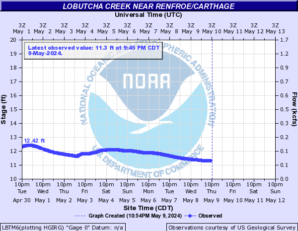
Lobutcha Creek (Click on an image to go to hydrograph webpage)
LBTM6:
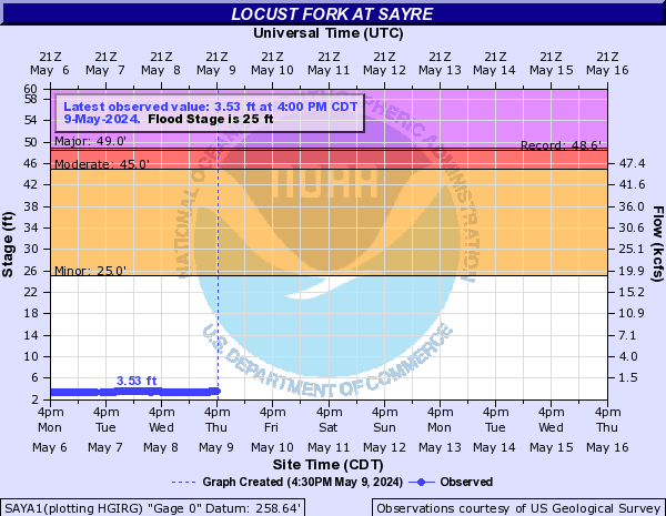
Locust Fork (Click on an image to go to hydrograph webpage)
SAYA1:
CLEA1:

Long Swamp Creek (Click on an image to go to hydrograph webpage)
BGDG1:
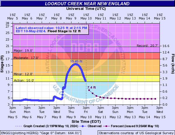
Lookout Creek (Click on an image to go to hydrograph webpage)
LKOT1:

ENGG1:
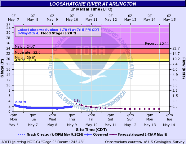
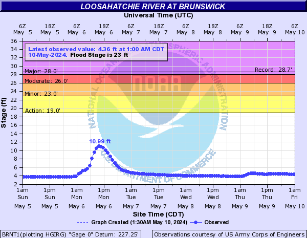
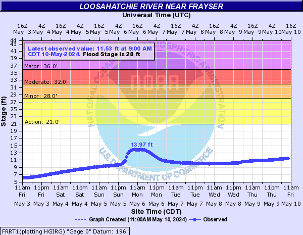
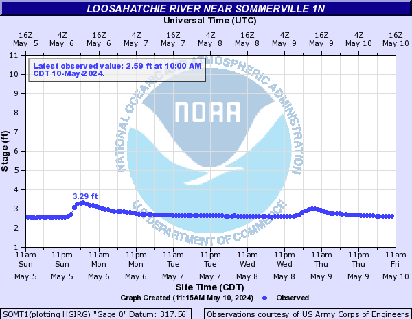
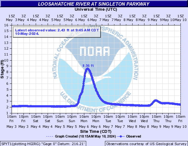
Loosahatchie River (Click on an image to go to hydrograph webpage)
ARLT1:
BRNT1:
FRRT1:
SOMT1:
SPYT1:
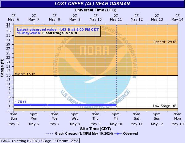
Lost Creek (AL) (Click on an image to go to hydrograph webpage)
PARA1:
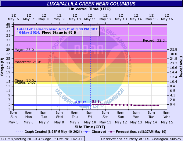
Luxapallila Creek (Click on an image to go to hydrograph webpage)
CLUM6:
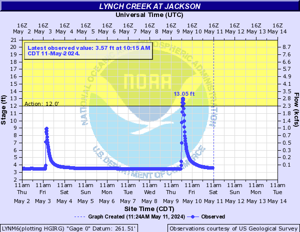
Lynch Creek (Click on an image to go to hydrograph webpage)
LYNM6:
Magnolia River (Click on an image to go to hydrograph webpage)
MAGA1:

Merritts Mill Pond Outfall (Click on an image to go to hydrograph webpage)
MMPF1:

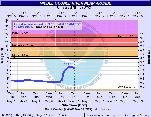
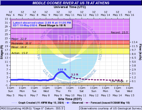
Middle Oconee River (Click on an image to go to hydrograph webpage)
ACDG1:
MOCG1:
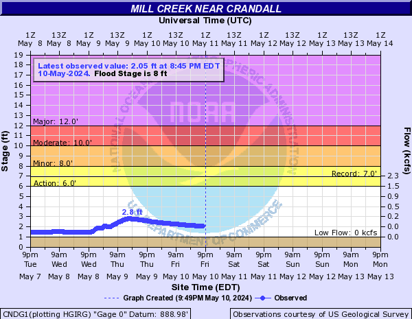
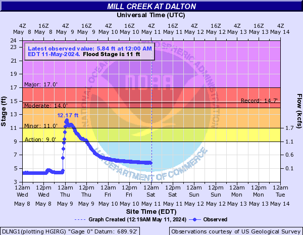
Mill Creek (Click on an image to go to hydrograph webpage)
CNDG1:
DLNG1:
Mill Creek (S MS) (Click on an image to go to hydrograph webpage)
MCFM6:
Mississippi River (Click on an image to go to hydrograph webpage)
OSGA4:

MEMT1:

TRPM6:

MHOM6:

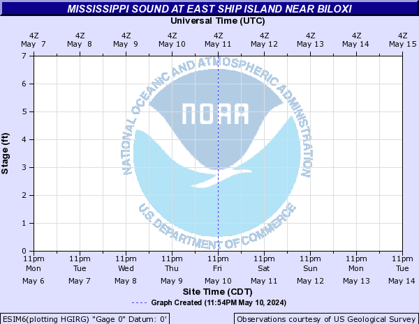
Mississippi Sound (Click on an image to go to hydrograph webpage)
RISM6:

GBGM6:
ESIM6:
GPLM6:

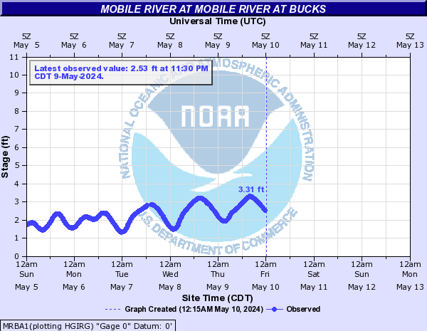
Mobile River (Click on an image to go to hydrograph webpage)
BCKA1:

MRBA1:
Morning Creek (Click on an image to go to hydrograph webpage)
MCFG1:

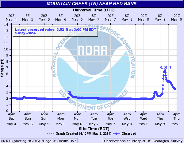
Mountain Creek (TN) (Click on an image to go to hydrograph webpage)
MCRT1:
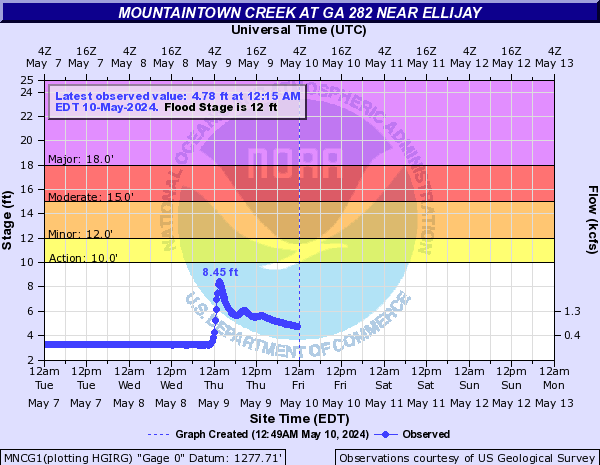
Mountaintown Creek (Click on an image to go to hydrograph webpage)
MNCG1:
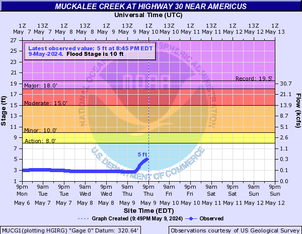
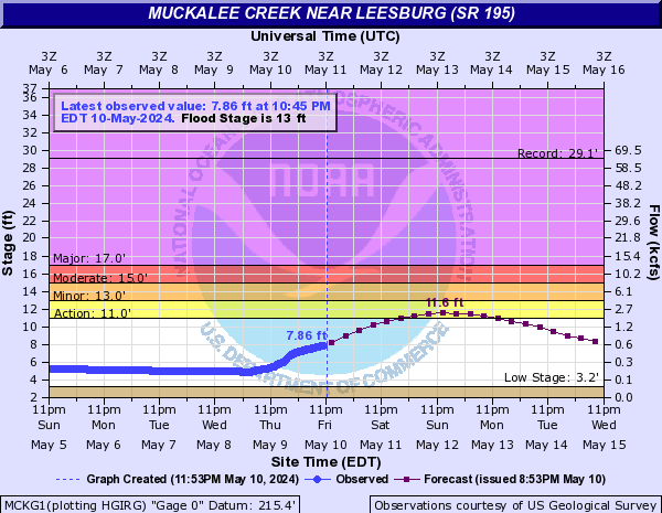
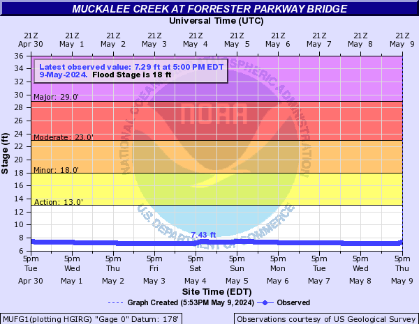
Muckalee Creek (Click on an image to go to hydrograph webpage)
MUCG1:
MCKG1:
MUFG1:
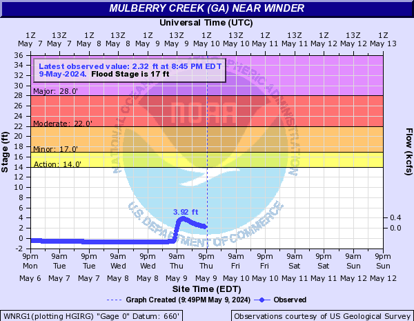
Mulberry Creek (GA) (Click on an image to go to hydrograph webpage)
WNRG1:
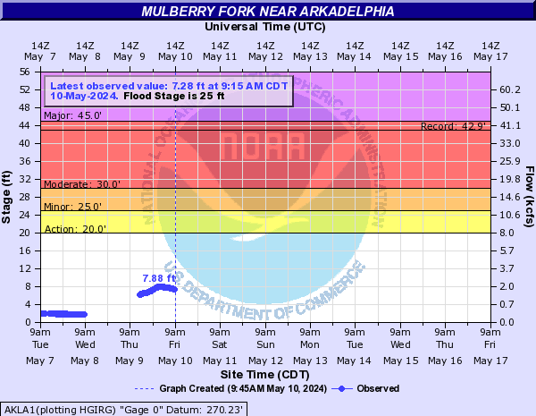
Mulberry Fork (Click on an image to go to hydrograph webpage)
AKLA1:
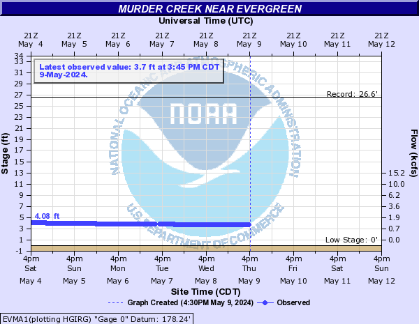
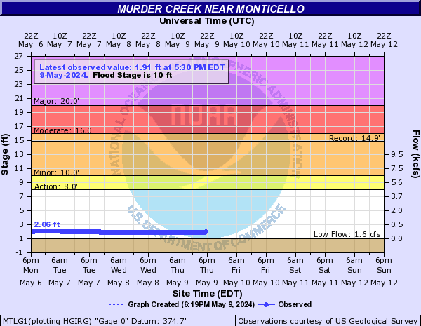
Murder Creek (Click on an image to go to hydrograph webpage)
EVMA1:
MTLG1:
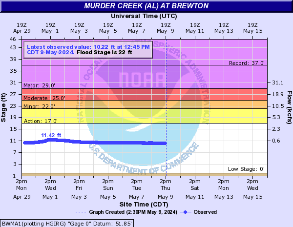
Murder Creek (AL) (Click on an image to go to hydrograph webpage)
BWMA1:
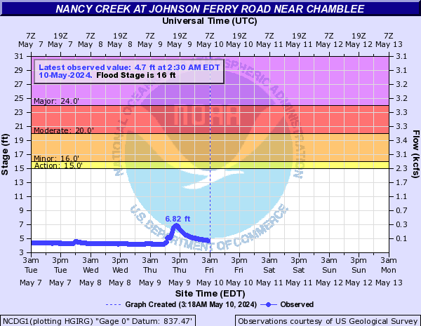
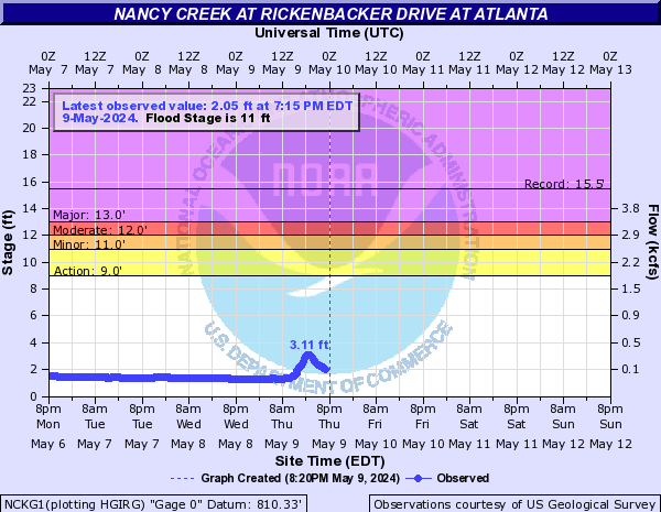
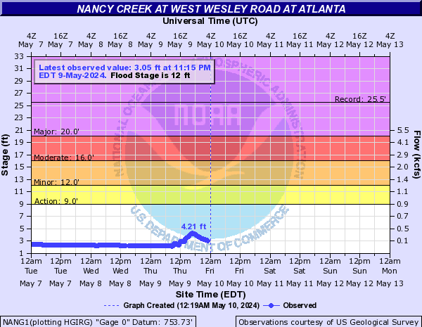
Nancy Creek (Click on an image to go to hydrograph webpage)
NCDG1:
NCKG1:
NANG1:
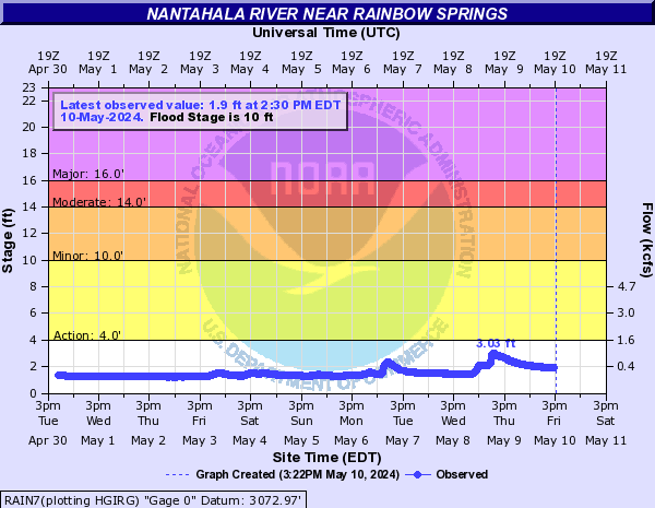
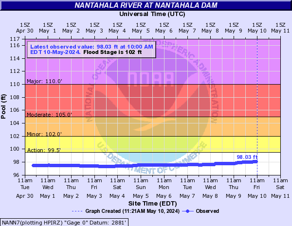
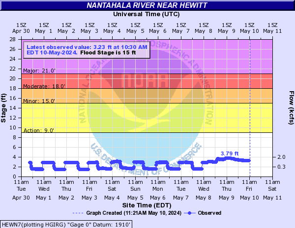
Nantahala River (Click on an image to go to hydrograph webpage)
RAIN7:
NANN7:
HEWN7:
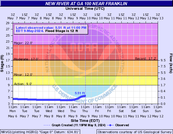
New River (Click on an image to go to hydrograph webpage)
NRVG1:
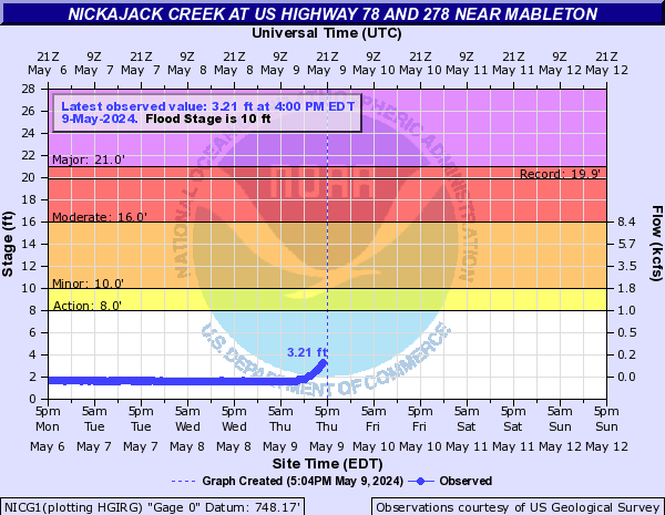
Nickajack Creek (Click on an image to go to hydrograph webpage)
NICG1:
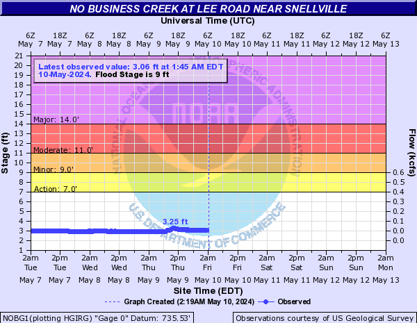
No Business Creek (Click on an image to go to hydrograph webpage)
NOBG1:
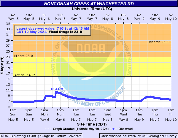
Nonconnah Creek (Click on an image to go to hydrograph webpage)
NONT1:
FRST1:

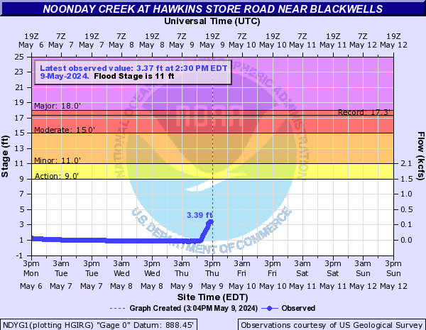
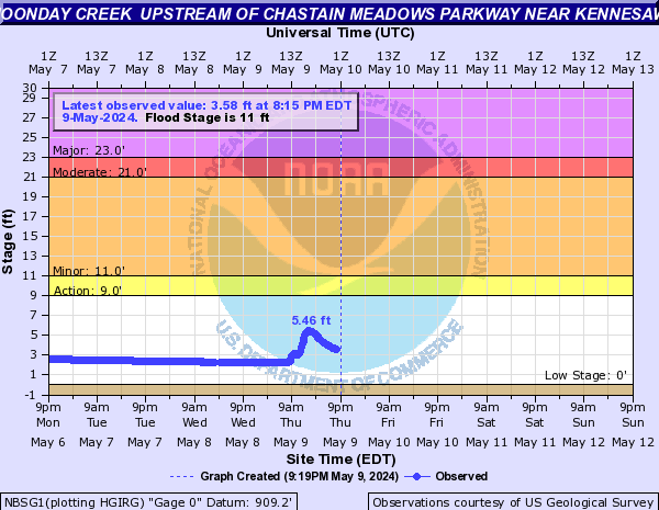
Noonday Creek (Click on an image to go to hydrograph webpage)
NDYG1:
NOOG1:

NBSG1:
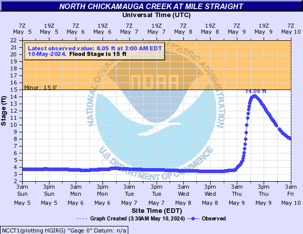
North Chickamauga Creek (Click on an image to go to hydrograph webpage)
NCCT1:
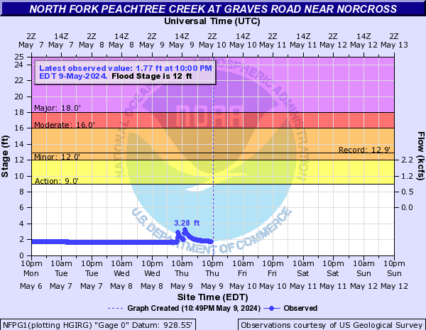
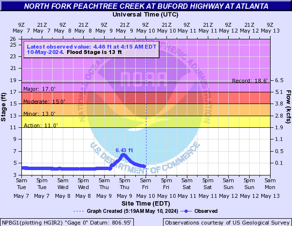
North Fork Peachtree Creek (Click on an image to go to hydrograph webpage)
NFPG1:
NPBG1:
NFBG1:

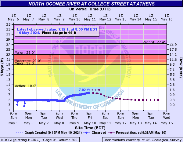
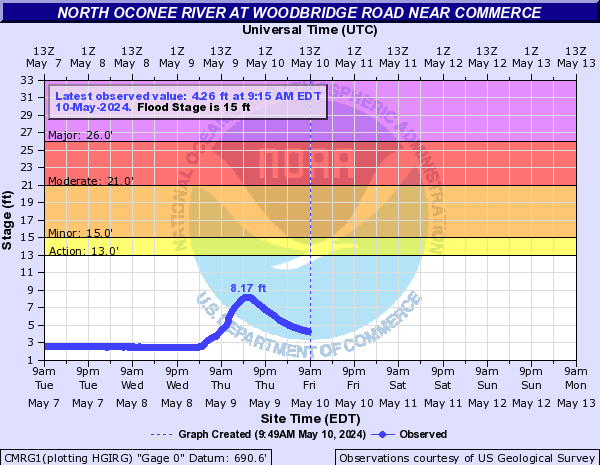
North Oconee River (Click on an image to go to hydrograph webpage)
NOCG1:
CMRG1:
Noses Creek (Click on an image to go to hydrograph webpage)
NOSG1:

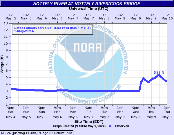
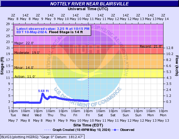
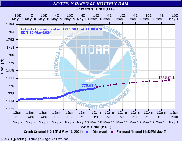
Nottely River (Click on an image to go to hydrograph webpage)
NCBN7:
BRVG1:

BLVG1:
NOTG1:
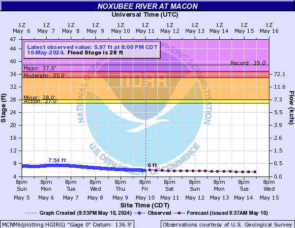
Noxubee River (Click on an image to go to hydrograph webpage)
MCNM6:
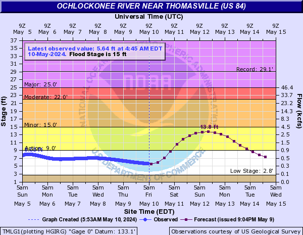
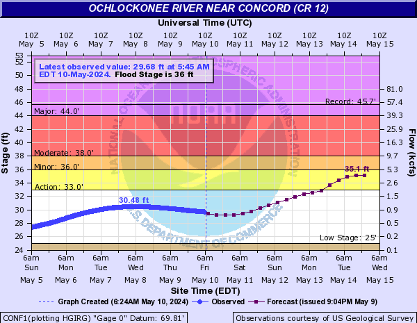
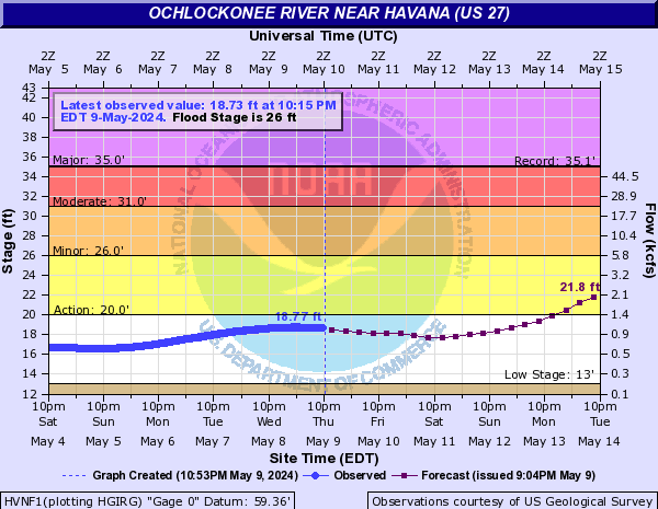
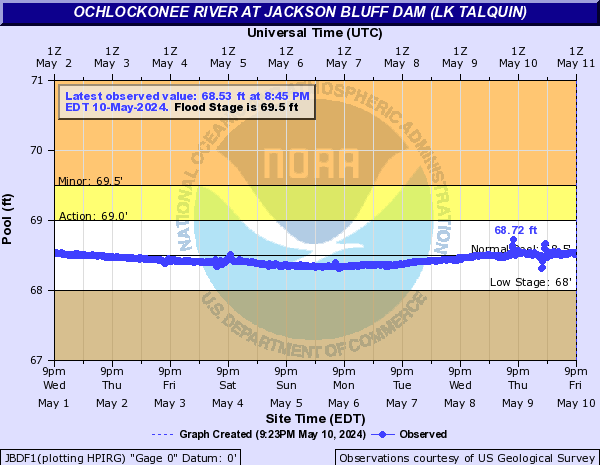
Ochlockonee River (Click on an image to go to hydrograph webpage)
CLDG1:

TMLG1:
CONF1:
HVNF1:
JBDF1:
BLXF1:

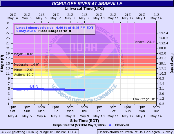
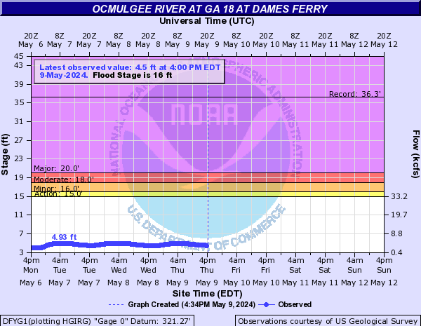
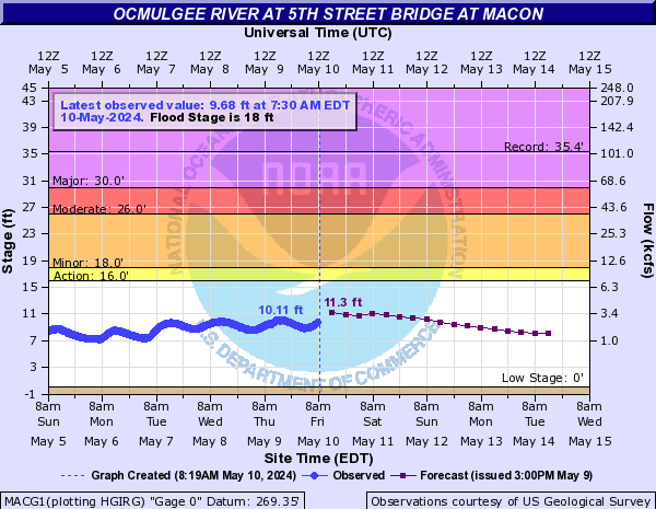
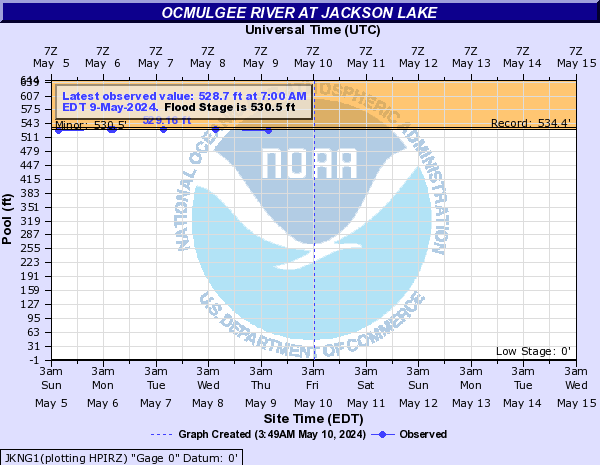
Ocmulgee River (Click on an image to go to hydrograph webpage)
HAWG1:

ABBG1:
DFYG1:
MACG1:
JACG1:
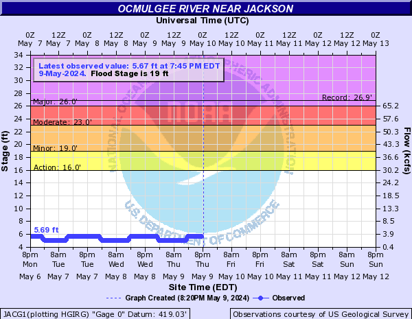
JKNG1:
Ocoee River (Click on an image to go to hydrograph webpage)
OCCT1:

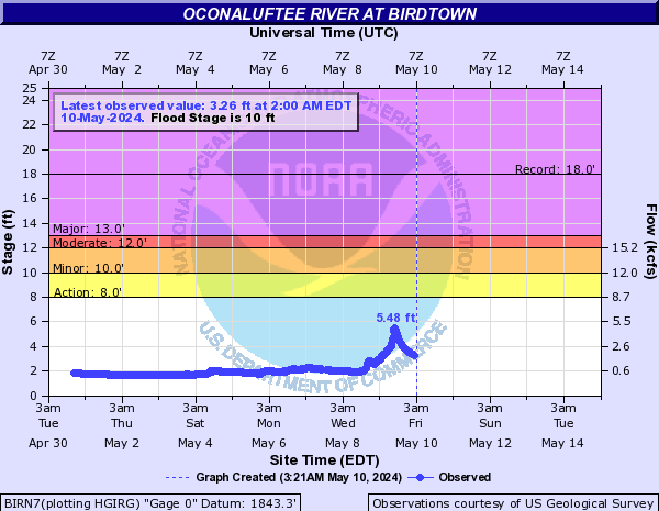
Oconaluftee River (Click on an image to go to hydrograph webpage)
BIRN7:
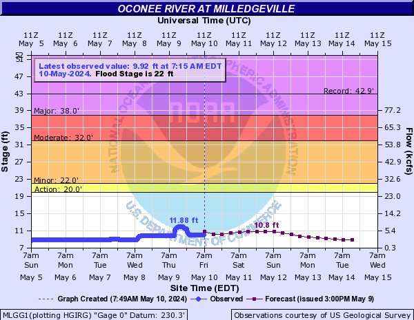
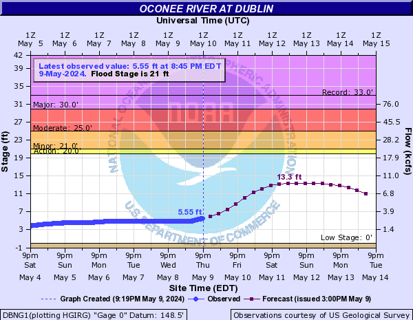
Oconee River (Click on an image to go to hydrograph webpage)
PNFG1:

WDMG1:

SNCG1:

MLGG1:
OCOG1:
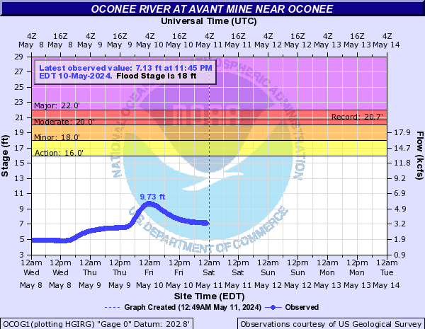
OCNG1:
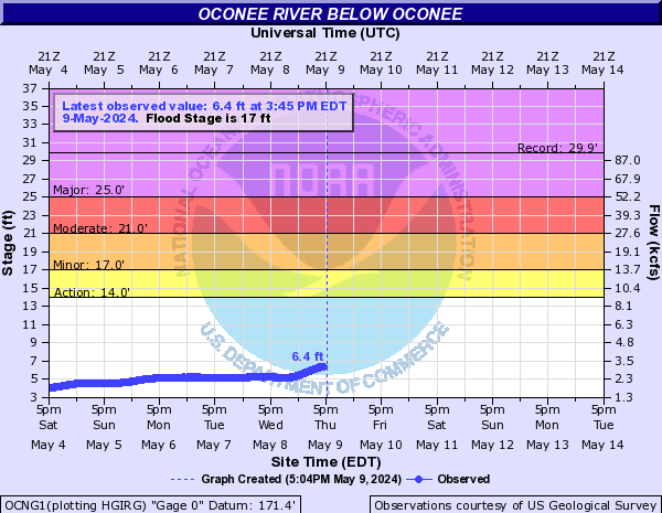
DBNG1:
Okapilco Creek (Click on an image to go to hydrograph webpage)
OKAG1:

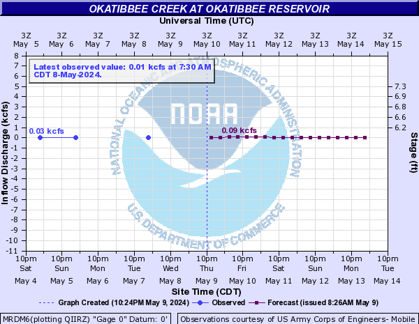
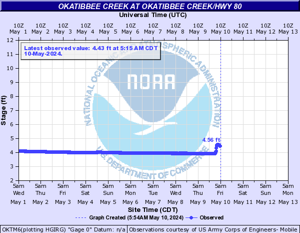
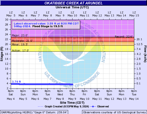
Okatibbee Creek (Click on an image to go to hydrograph webpage)
MRDM6:
OKTM6:
OARM6:
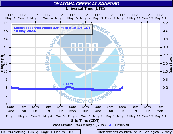
Okatoma Creek (Click on an image to go to hydrograph webpage)
OKCM6:
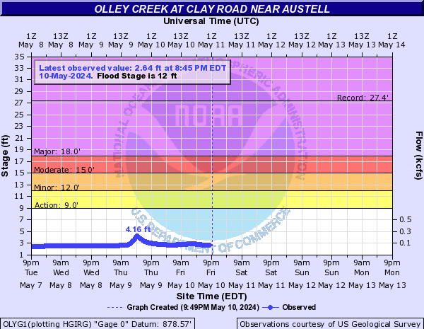
Olley Creek (Click on an image to go to hydrograph webpage)
OLYG1:
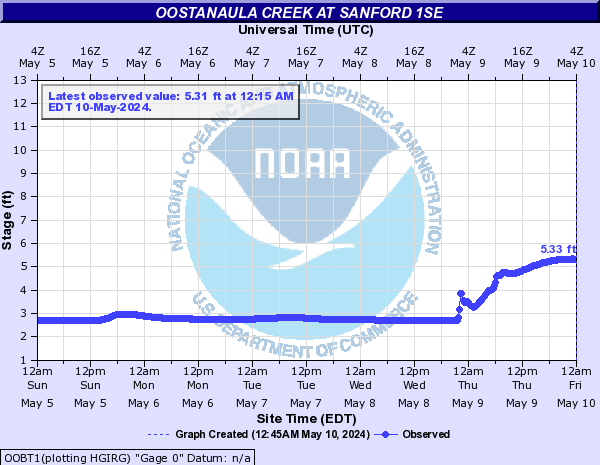
Oostanaula Creek (Click on an image to go to hydrograph webpage)
OOBT1:
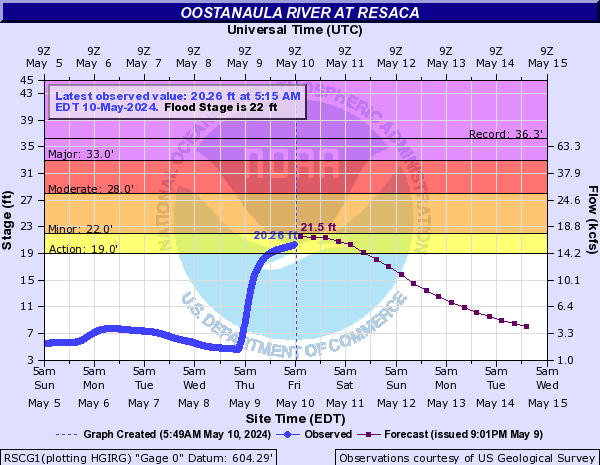
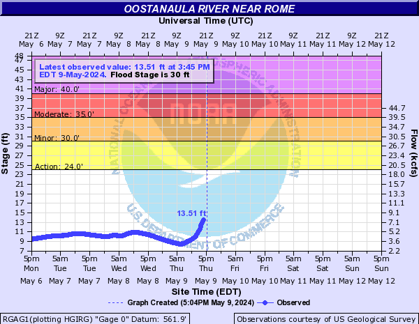
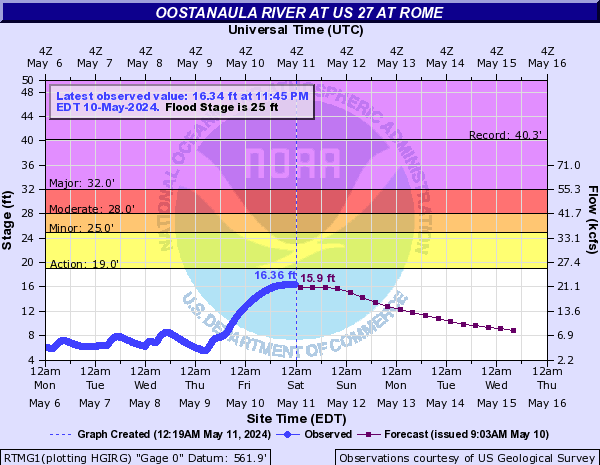
Oostanaula River (Click on an image to go to hydrograph webpage)
RSCG1:
CALG1:

RGAG1:
RTMG1:
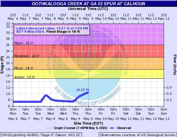
Oothkalooga Creek (Click on an image to go to hydrograph webpage)
OTKG1:
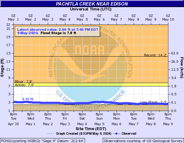
Pachitla Creek (Click on an image to go to hydrograph webpage)
PCHG1:
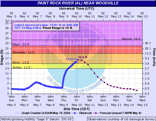
Paint Rock River (AL) (Click on an image to go to hydrograph webpage)
WDVA1:
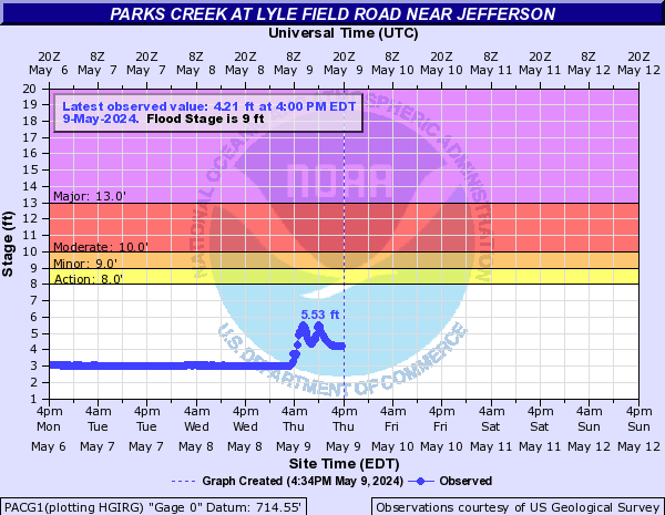
Parks Creek (Click on an image to go to hydrograph webpage)
PACG1:
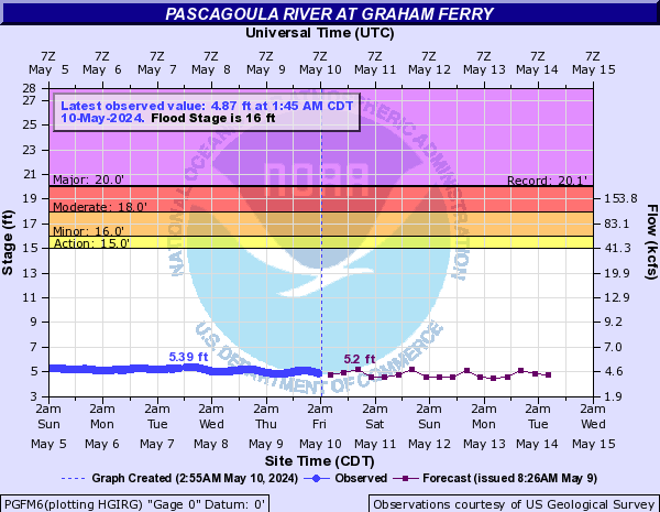
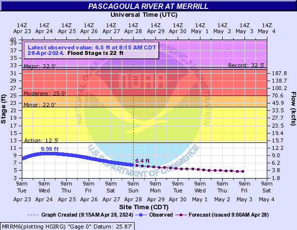
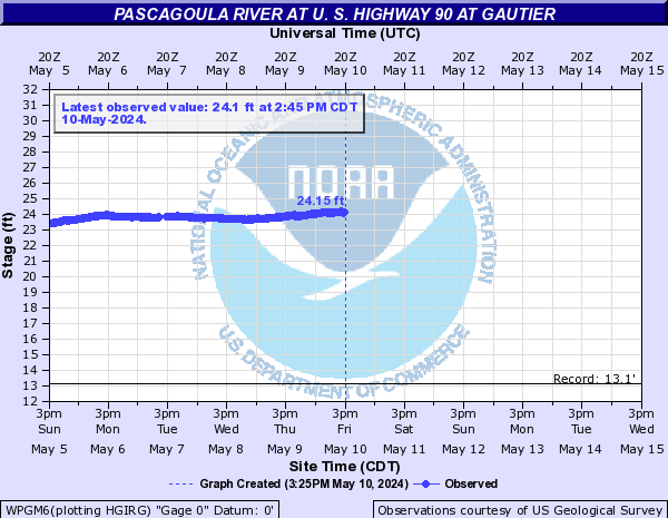
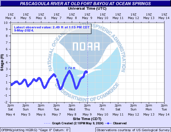
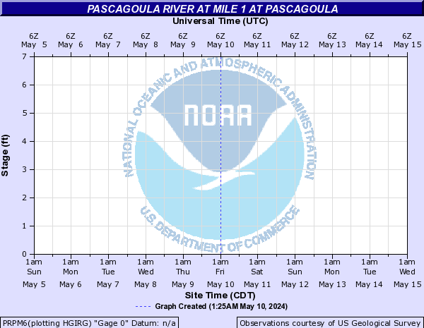
Pascagoula River (Click on an image to go to hydrograph webpage)
PGFM6:
MRRM6:
WPGM6:
OFBM6:
PRPM6:
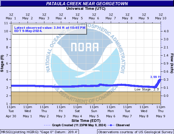
Pataula Creek (Click on an image to go to hydrograph webpage)
MRSG1:
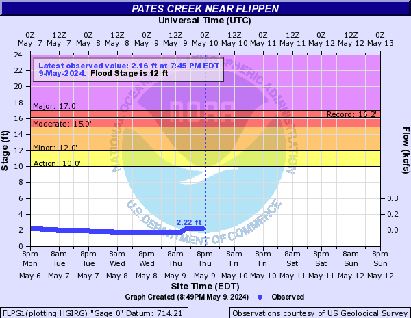
Pates Creek (Click on an image to go to hydrograph webpage)
FLPG1:
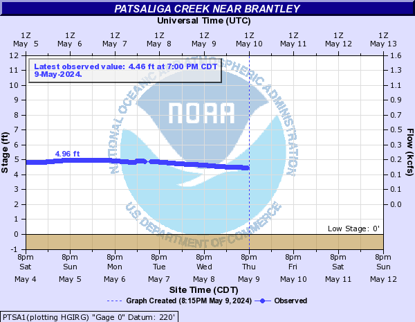
Patsaliga Creek (Click on an image to go to hydrograph webpage)
PTSA1:
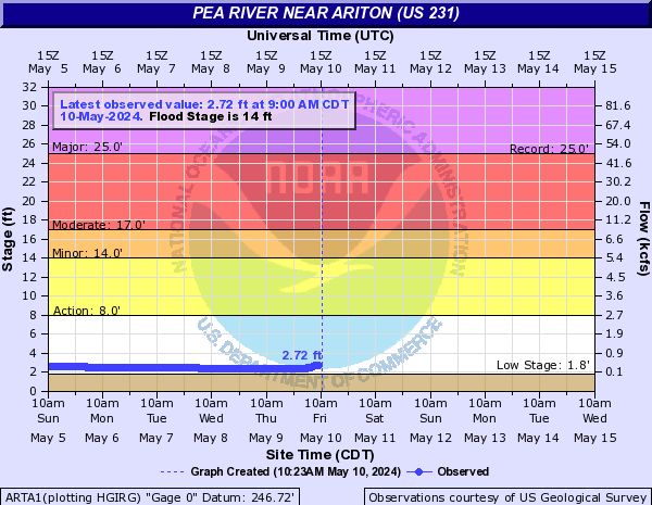
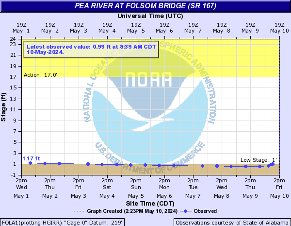
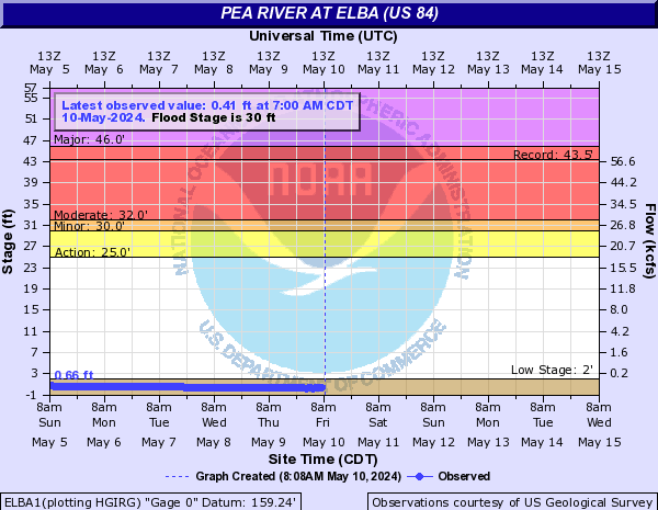
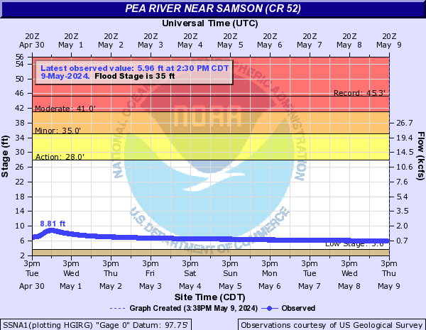
Pea River (Click on an image to go to hydrograph webpage)
ARTA1:
FOLA1:
ELBA1:
SSNA1:
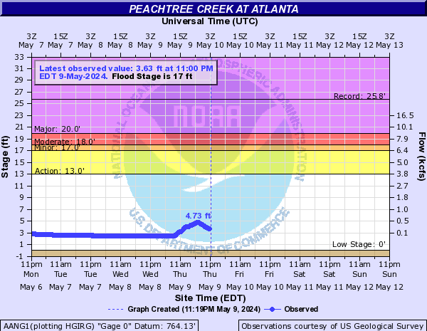
Peachtree Creek (Click on an image to go to hydrograph webpage)
AANG1:
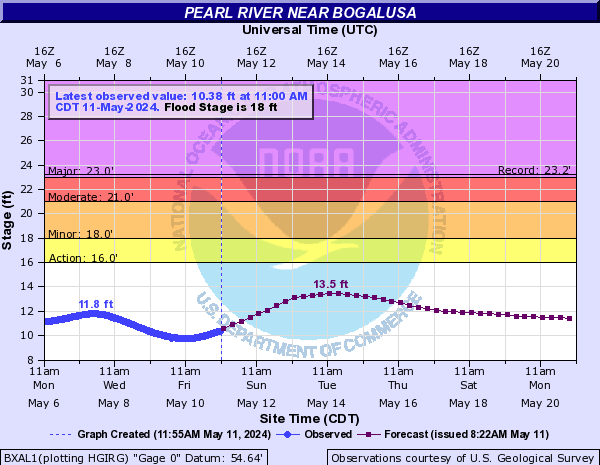
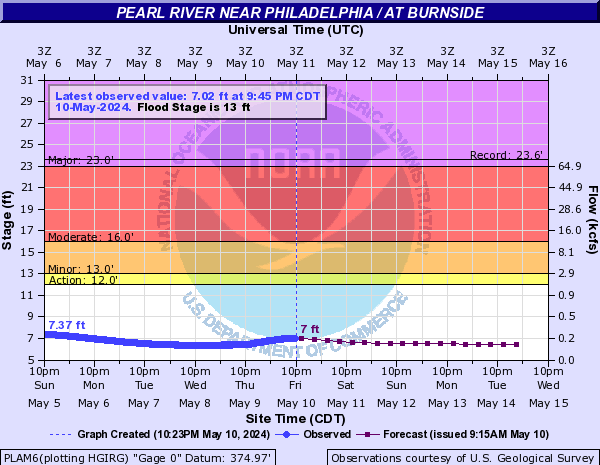
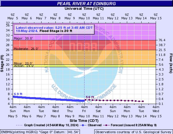
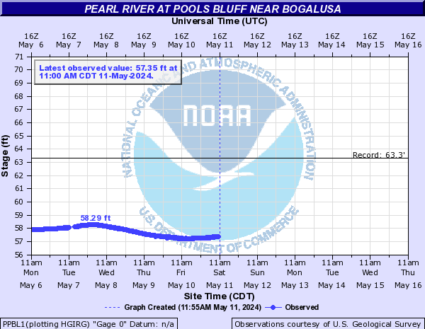
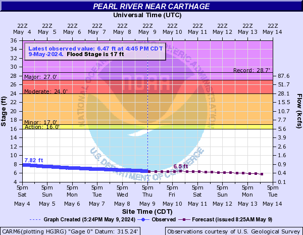
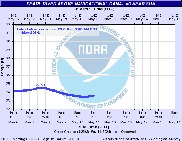
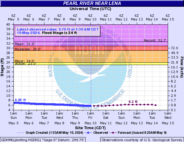
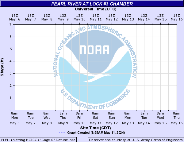
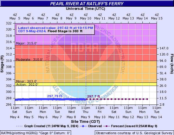
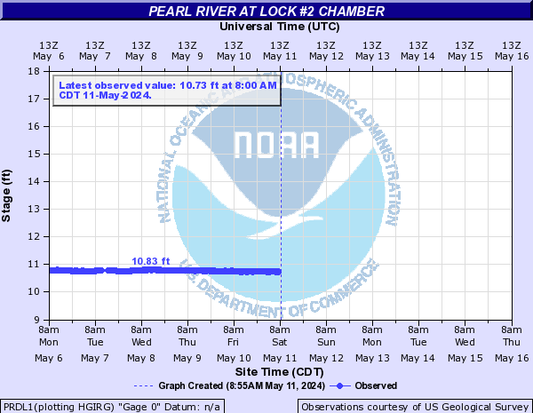
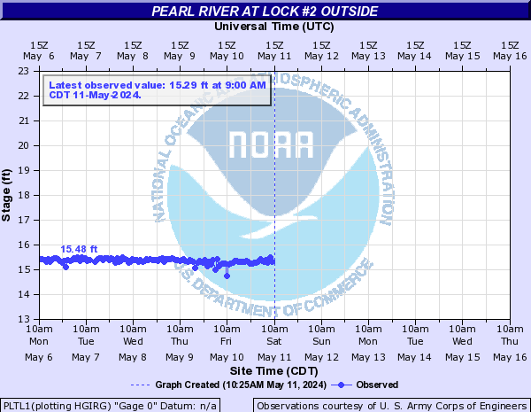
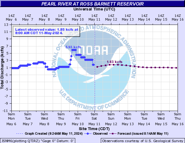
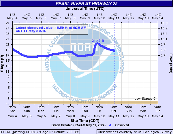
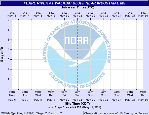
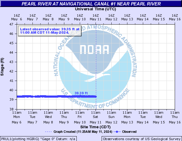
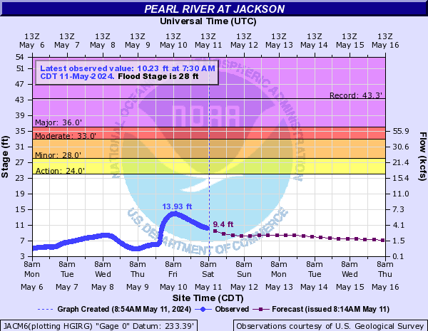
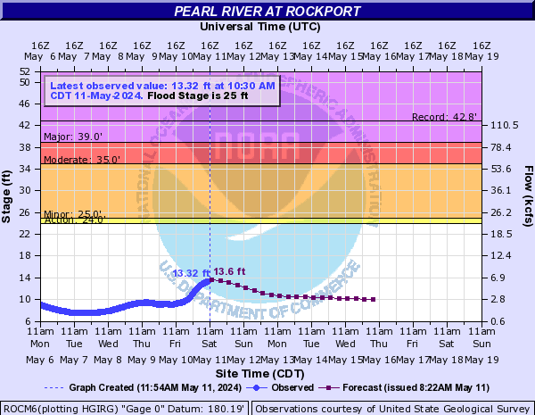
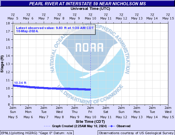
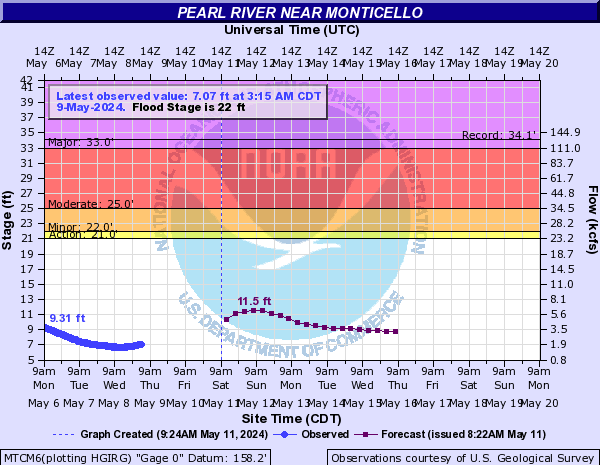
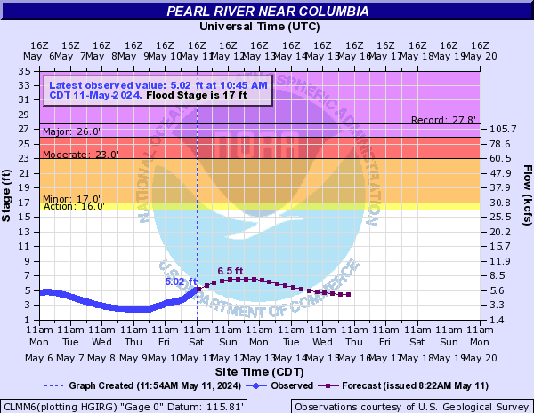
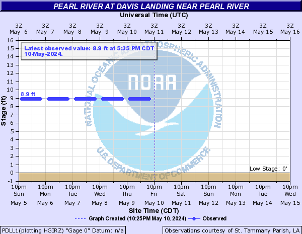
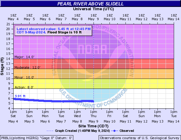
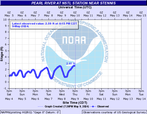
Pearl River (Click on an image to go to hydrograph webpage)
BXAL1:
PLAM6:
ENBM6:
PPBL1:
CARM6:
PRTL1:
GDHM6:
PLEL1:
RATM6:
PRDL1:
PLTL1:
JSNM6:
HCFM6:
WSWM6:
PRUL1:
JACM6:
ROCM6:
PLOL1:
EPNL1:
MTCM6:
CLMM6:
PERL1:

PDLL1:
PRBL1:
NAPM6:
Peeks Creek (Click on an image to go to hydrograph webpage)
CUSN7:
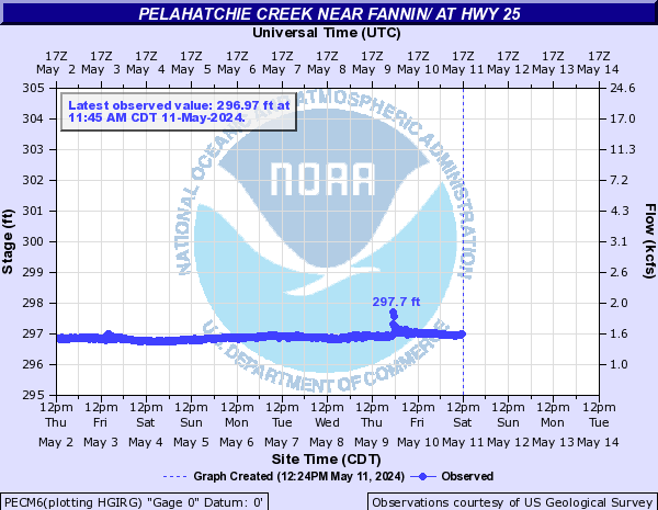
Pelahatchie Creek (Click on an image to go to hydrograph webpage)
PECM6:
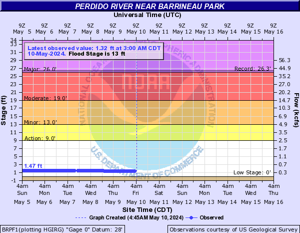
Perdido River (Click on an image to go to hydrograph webpage)
BRPF1:
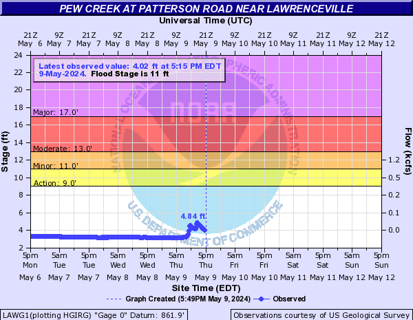
Pew Creek (Click on an image to go to hydrograph webpage)
LAWG1:
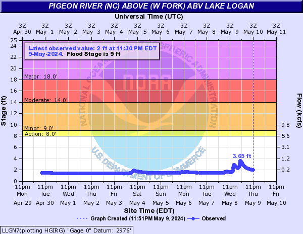
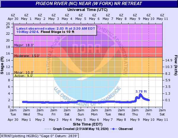
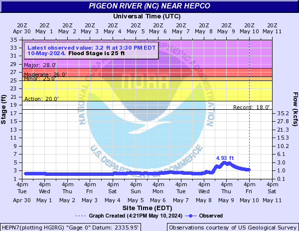
Pigeon River (NC) (Click on an image to go to hydrograph webpage)
LLGN7:
RTRN7:
HEPN7:
Pine Barren Creek (Click on an image to go to hydrograph webpage)
SNOA1:

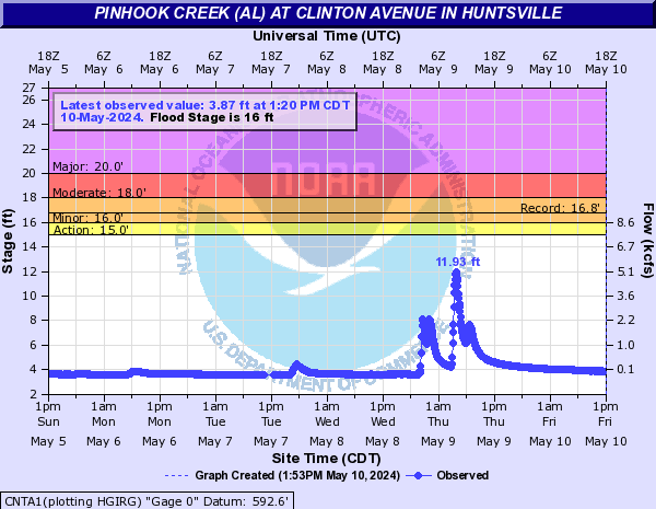
Pinhook Creek (AL) (Click on an image to go to hydrograph webpage)
CNTA1:
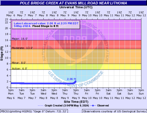
Pole Bridge Creek (Click on an image to go to hydrograph webpage)
PBCG1:
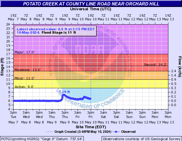
Potato Creek (Click on an image to go to hydrograph webpage)
POTG1:
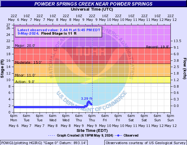
Powder Springs Creek (Click on an image to go to hydrograph webpage)
POWG1:
Proctor Creek (Click on an image to go to hydrograph webpage)
PRCG1:

PCTG1:
Proctor Creek Tributary (Click on an image to go to hydrograph webpage)
PCSG1:

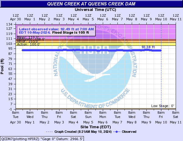
Queen Creek (Click on an image to go to hydrograph webpage)
QCDN7:
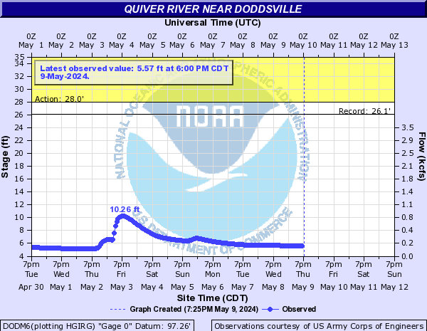
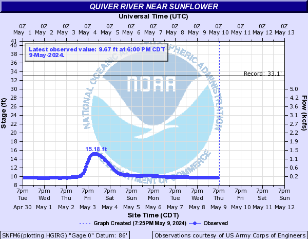
Quiver River (Click on an image to go to hydrograph webpage)
DODM6:
SNFM6:
Raven Fork Creek (Click on an image to go to hydrograph webpage)
CTFN7:

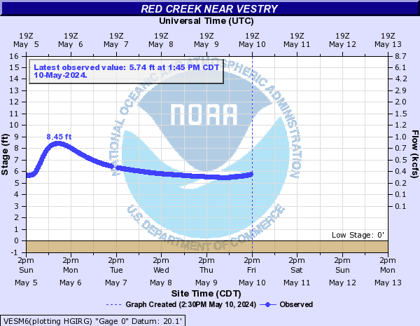
Red Creek (Click on an image to go to hydrograph webpage)
VESM6:
PRKM6:

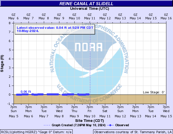
Reine Canal (Click on an image to go to hydrograph webpage)
RCSL1:
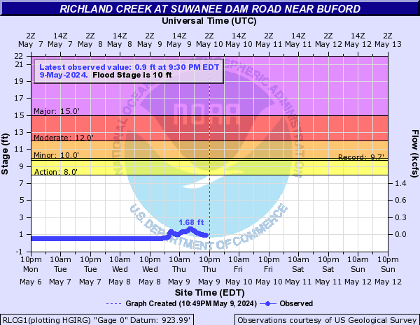
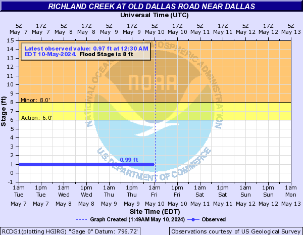
Richland Creek (Click on an image to go to hydrograph webpage)
RLCG1:
PLKT1:

RCDG1:
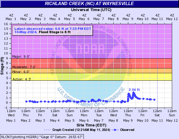
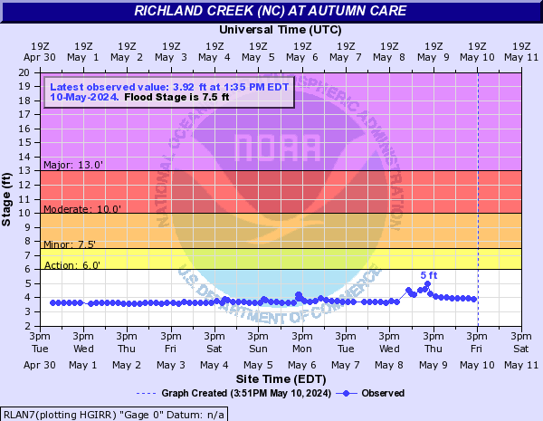
Richland Creek (NC) (Click on an image to go to hydrograph webpage)
RLCN7:
RLAN7:
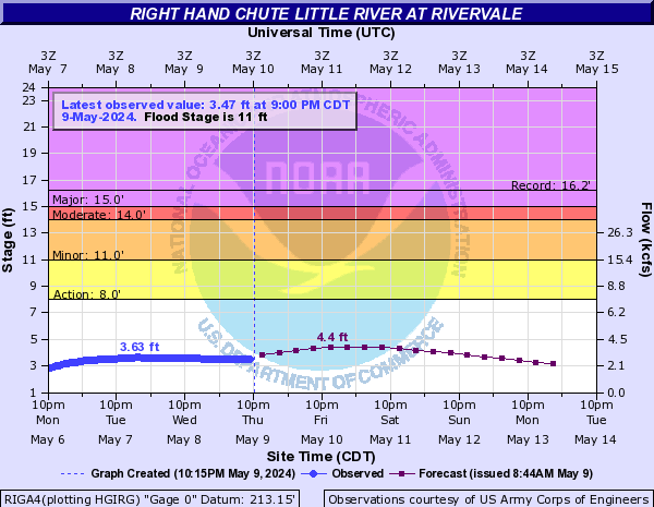
Right Hand Chute Little River (Click on an image to go to hydrograph webpage)
RIGA4:
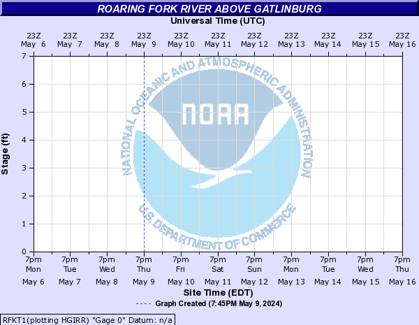
Roaring Fork River (Click on an image to go to hydrograph webpage)
RFKT1:
Robinson Creek (NC) (Click on an image to go to hydrograph webpage)
IRCN7:

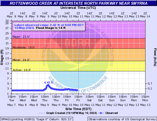
Rottenwood Creek (Click on an image to go to hydrograph webpage)
SMAG1:
Russell Creek (GA) (Click on an image to go to hydrograph webpage)
RUSG1:

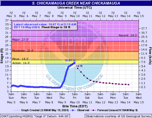
S. Chickamauga Creek (Click on an image to go to hydrograph webpage)
CHKT1:
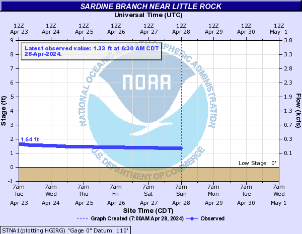
Sardine Branch (Click on an image to go to hydrograph webpage)
STNA1:
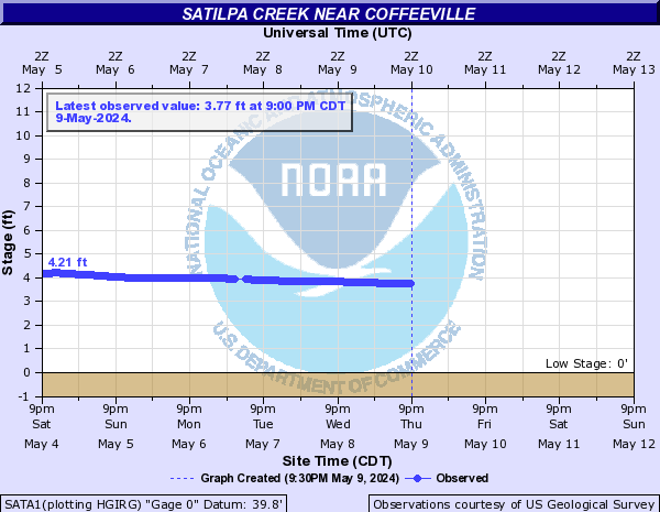
Satilpa Creek (Click on an image to go to hydrograph webpage)
SATA1:
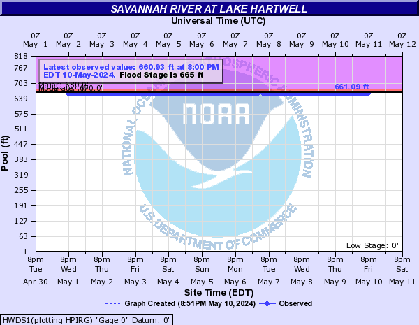
Savannah River (Click on an image to go to hydrograph webpage)
HWDS1:
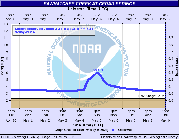
Sawhatchee Creek (Click on an image to go to hydrograph webpage)
CEDG1:
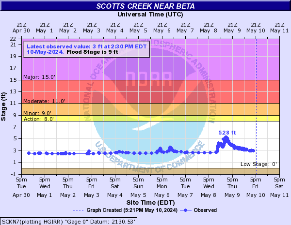
Scotts Creek (Click on an image to go to hydrograph webpage)
SCKN7:
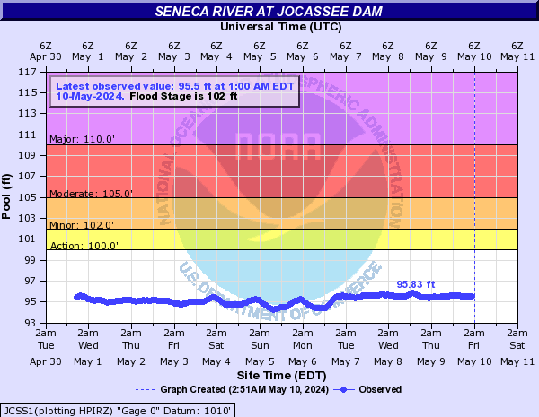
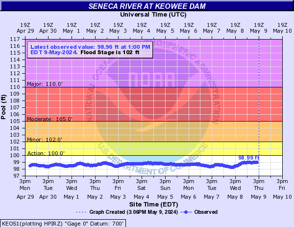
Seneca River (Click on an image to go to hydrograph webpage)
JCSS1:
KEOS1:
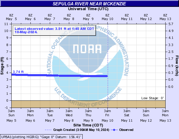
Sepulga River (Click on an image to go to hydrograph webpage)
UPBA1:
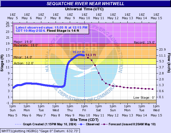
Sequatchie River (Click on an image to go to hydrograph webpage)
WHTT1:
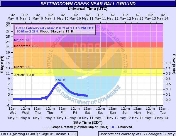
Settingdown Creek (Click on an image to go to hydrograph webpage)
FREG1:
Sewee Creek (Click on an image to go to hydrograph webpage)
SEET1:

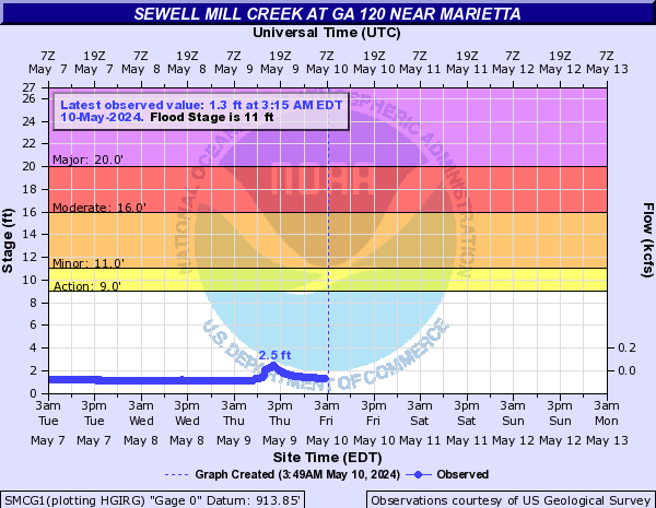
Sewell Mill Creek (Click on an image to go to hydrograph webpage)
SMCG1:
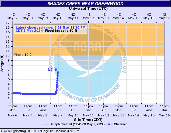
Shades Creek (Click on an image to go to hydrograph webpage)
GWDA1:
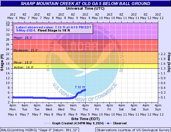
Sharp Mountain Creek (Click on an image to go to hydrograph webpage)
BALG1:
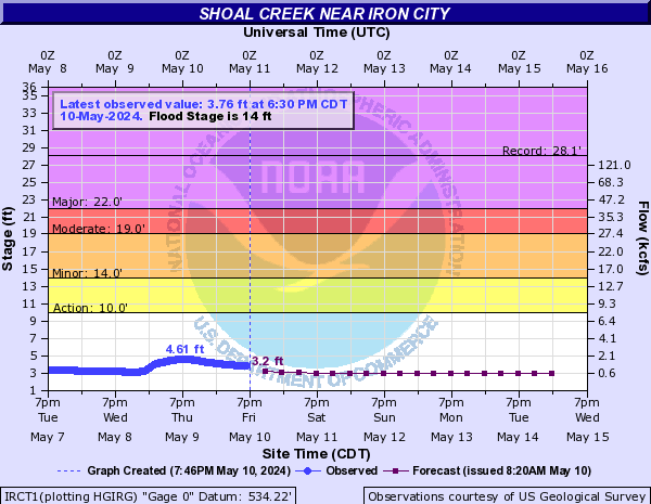
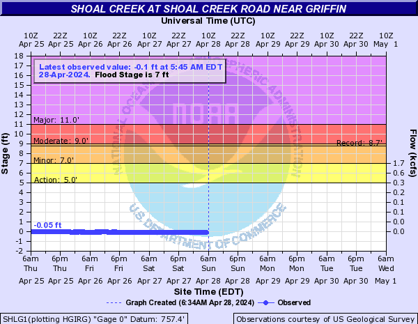
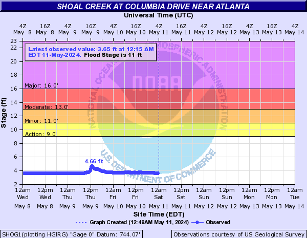
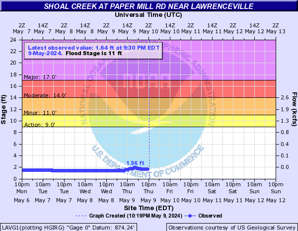
Shoal Creek (Click on an image to go to hydrograph webpage)
IRCT1:
SHLG1:
SHOG1:
SHPG1:

WALG1:

LAVG1:
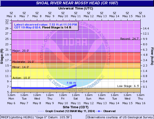
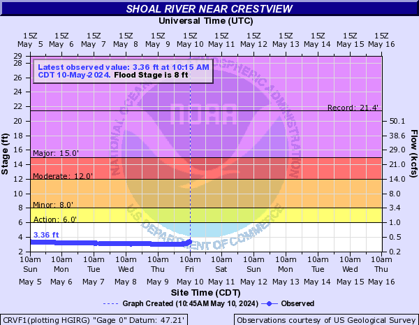
Shoal River (Click on an image to go to hydrograph webpage)
MHDF1:
CRVF1:
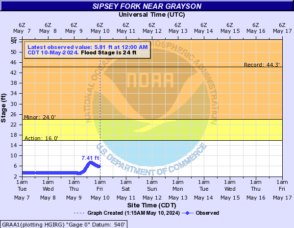
Sipsey Fork (Click on an image to go to hydrograph webpage)
GRAA1:
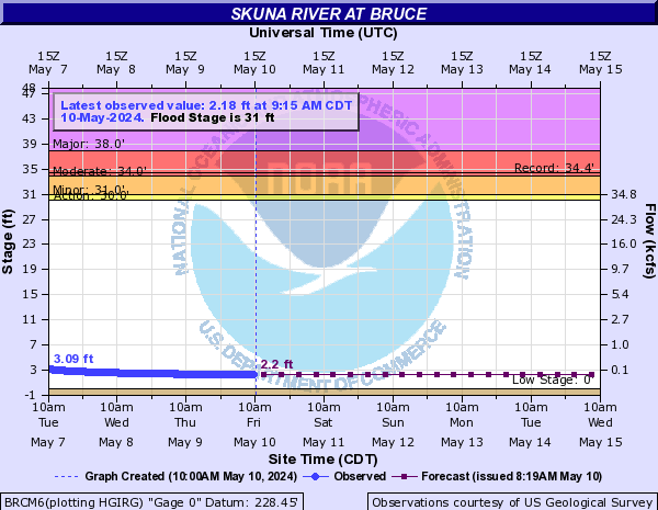
Skuna River (Click on an image to go to hydrograph webpage)
BRCM6:
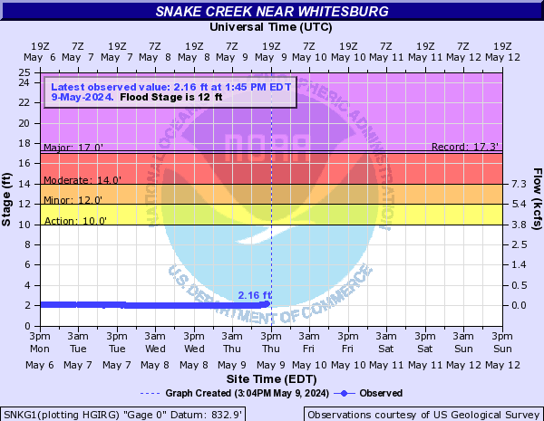
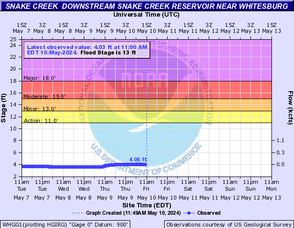
Snake Creek (Click on an image to go to hydrograph webpage)
SNKG1:
WHGG1:
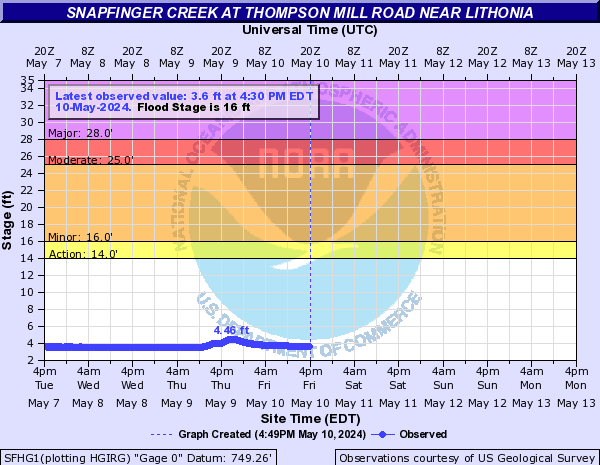
Snapfinger Creek (Click on an image to go to hydrograph webpage)
SFCG1:

SFHG1:
Snowbird Creek (Click on an image to go to hydrograph webpage)
SBRN7:

Soco Creek (Click on an image to go to hydrograph webpage)
SCCN7:

SWTN7:

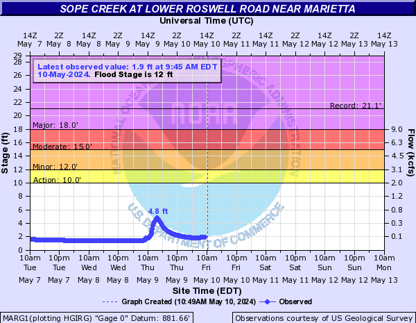
Sope Creek (Click on an image to go to hydrograph webpage)
MARG1:
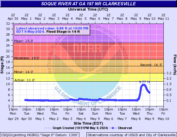
Soque River (Click on an image to go to hydrograph webpage)
CSQG1:
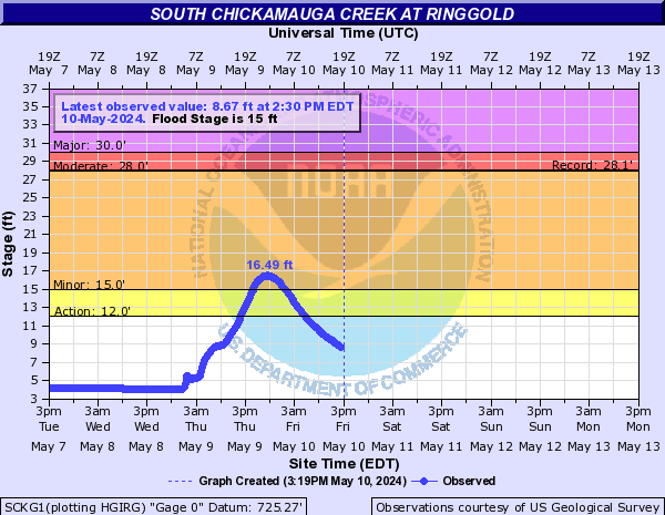
South Chickamauga Creek (Click on an image to go to hydrograph webpage)
SCKG1:
South Fork Broad River (Click on an image to go to hydrograph webpage)
CAOG1:

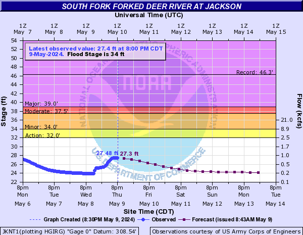
South Fork Forked Deer River (Click on an image to go to hydrograph webpage)
JKNT1:
BLST1:

South Fork Peachtree Creek (Click on an image to go to hydrograph webpage)
SFPG1:

SPJG1:

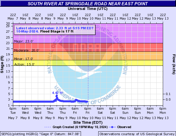
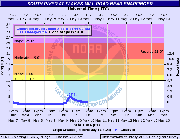
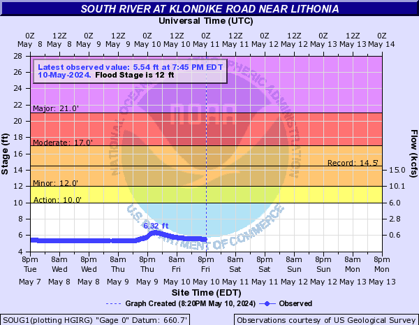
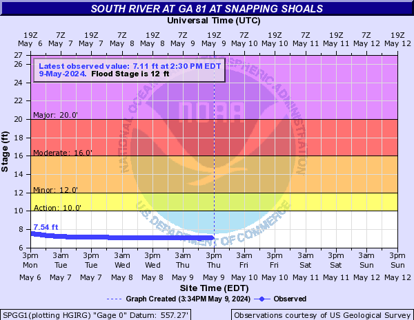
South River (Click on an image to go to hydrograph webpage)
SEPG1:
STHG1:

SFMG1:
SOUG1:
SPGG1:
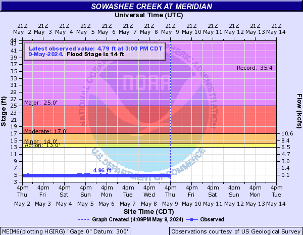
Sowashee Creek (Click on an image to go to hydrograph webpage)
MEIM6:
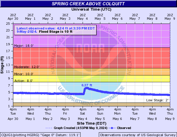
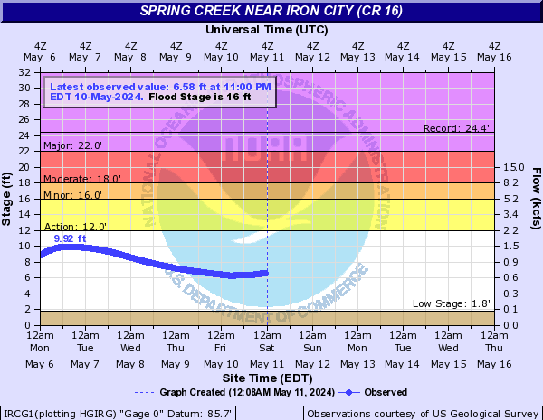
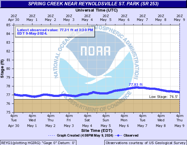
Spring Creek (Click on an image to go to hydrograph webpage)
CQUG1:
IRCG1:
REYG1:
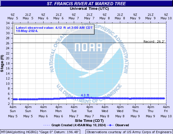
St. Francis River (Click on an image to go to hydrograph webpage)
MTOA4:
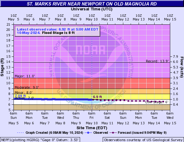
St. Marks River (Click on an image to go to hydrograph webpage)
NEPF1:
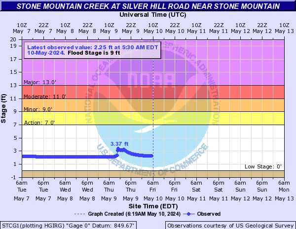
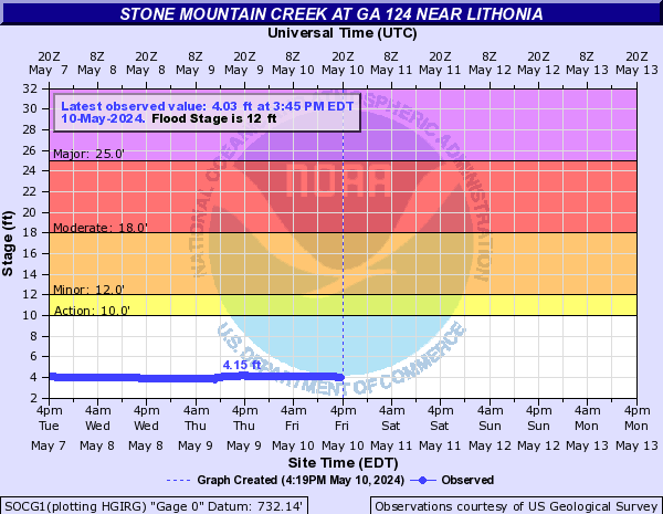
Stone Mountain Creek (Click on an image to go to hydrograph webpage)
STCG1:
SOCG1:
Straight Fork Creek (Click on an image to go to hydrograph webpage)
SFKN7:

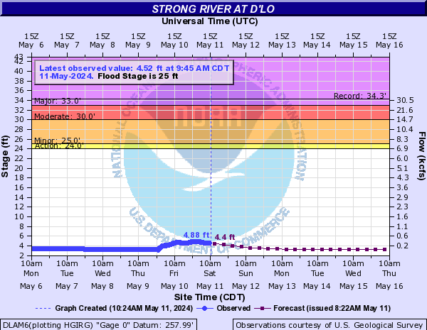
Strong River (Click on an image to go to hydrograph webpage)
DLAM6:
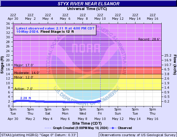
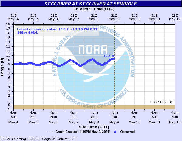
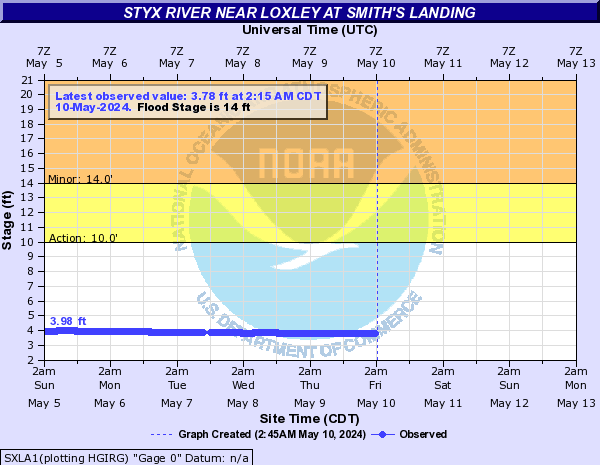
Styx River (Click on an image to go to hydrograph webpage)
STXA1:
SRSA1:
SXLA1:
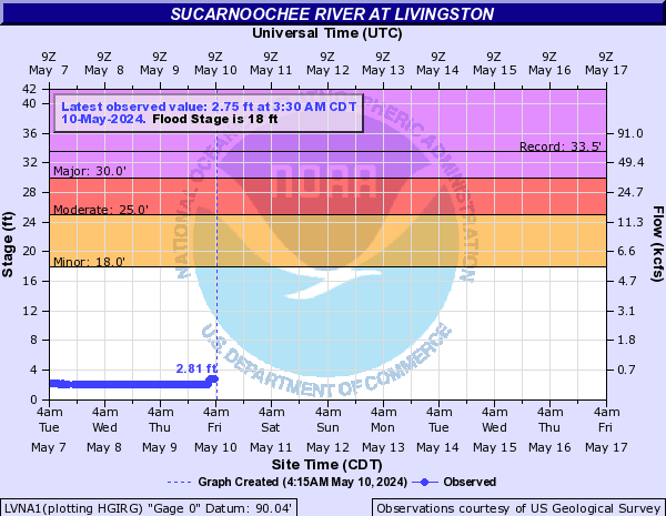
Sucarnoochee River (Click on an image to go to hydrograph webpage)
LVNA1:
Suwanee Creek (Click on an image to go to hydrograph webpage)
SWEG1:

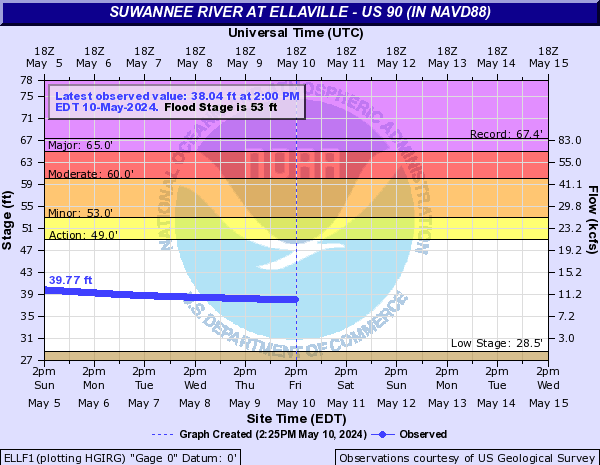
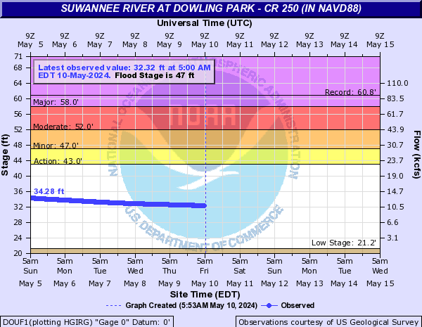
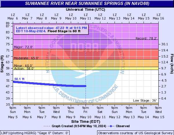
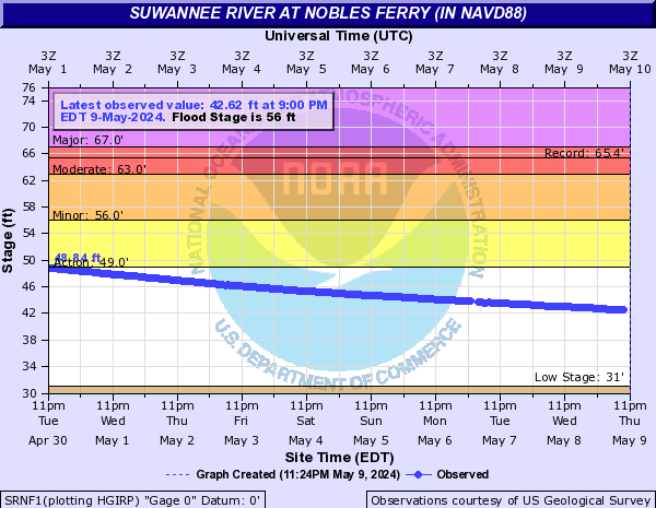
Suwannee River (Click on an image to go to hydrograph webpage)
ELLF1:
DOUF1:
LIKF1:
SRNF1:
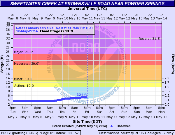
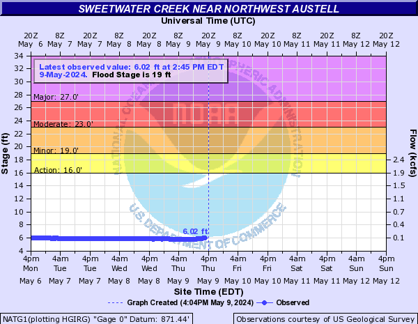
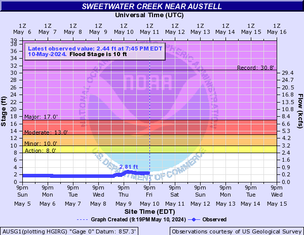
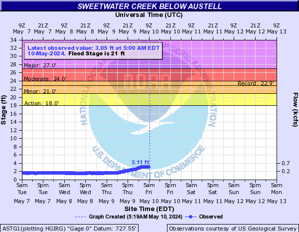
Sweetwater Creek (Click on an image to go to hydrograph webpage)
PDSG1:
NATG1:
AUSG1:
ASTG1:
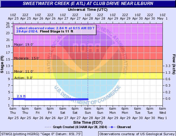
Sweetwater Creek (E ATL) (Click on an image to go to hydrograph webpage)
STWG1:
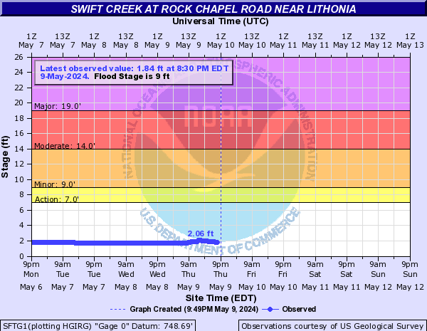
Swift Creek (Click on an image to go to hydrograph webpage)
SFTG1:
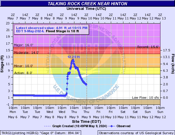
Talking Rock Creek (Click on an image to go to hydrograph webpage)
TKRG1:
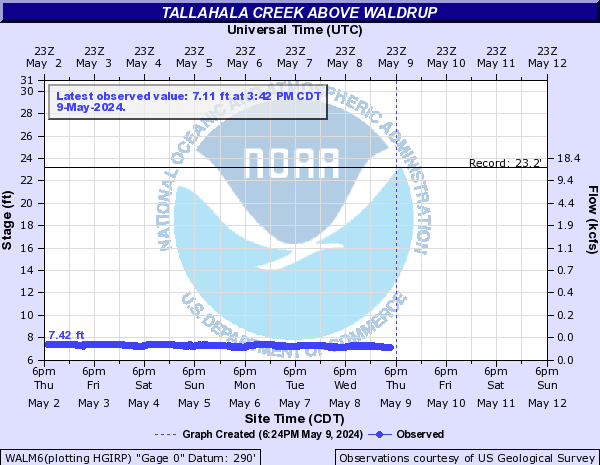
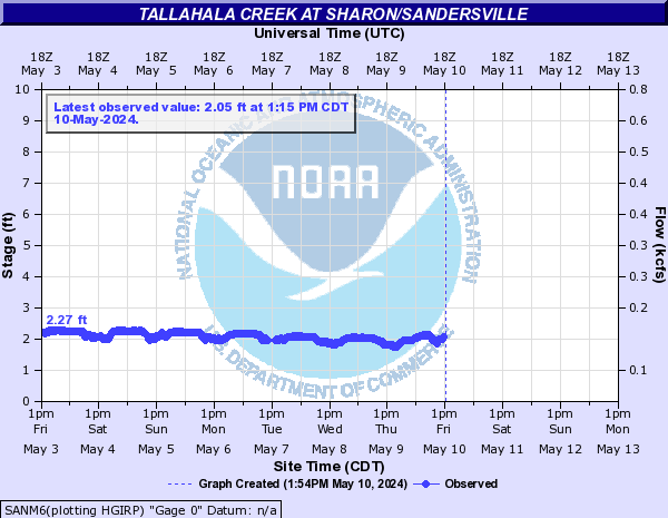
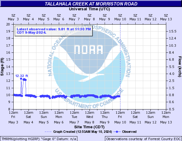
Tallahala Creek (Click on an image to go to hydrograph webpage)
RNTM6:

WALM6:
SANM6:
LURM6:

TMRM6:
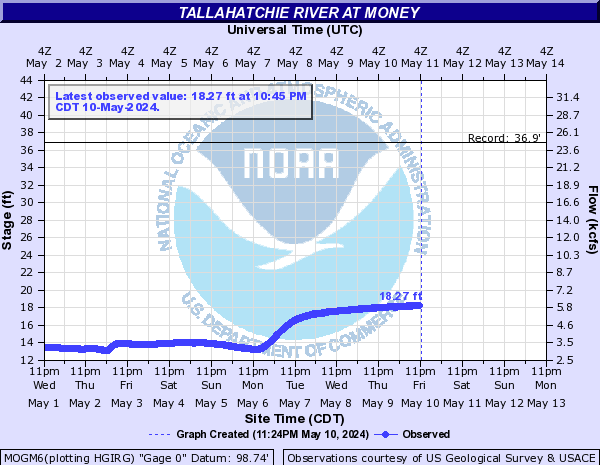
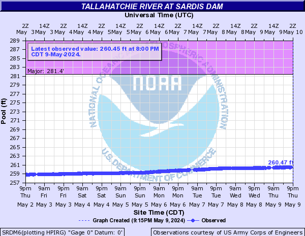
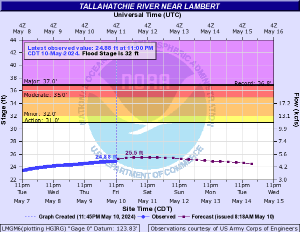
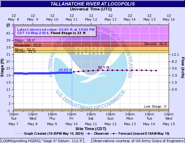
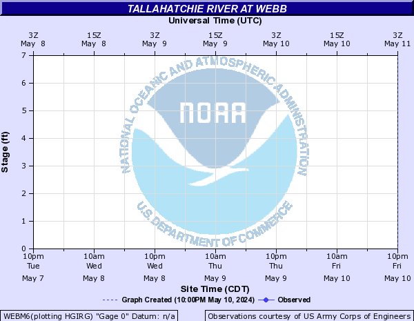
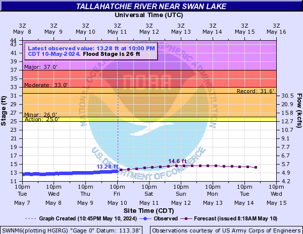
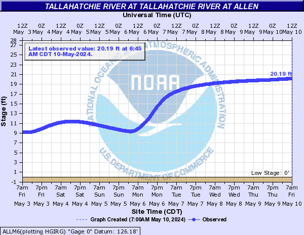
Tallahatchie River (Click on an image to go to hydrograph webpage)
MOGM6:
SRDM6:
LMGM6:
LOGM6:
WEBM6:
SWNM6:
ALLM6:
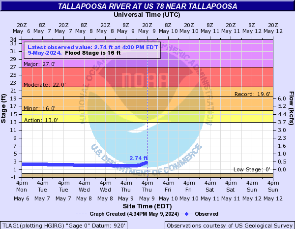
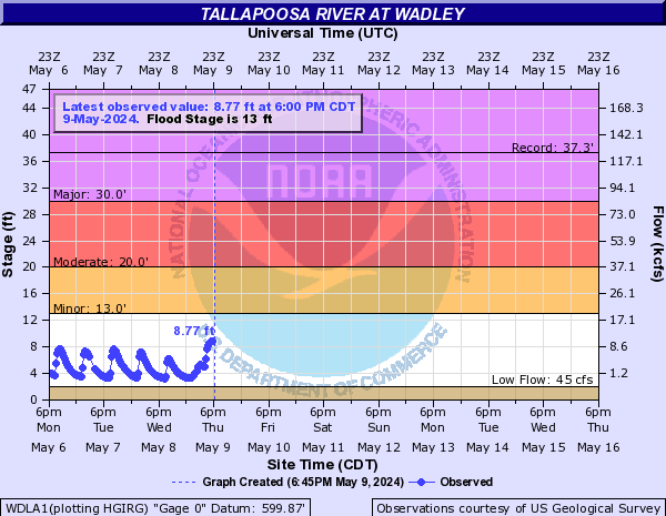
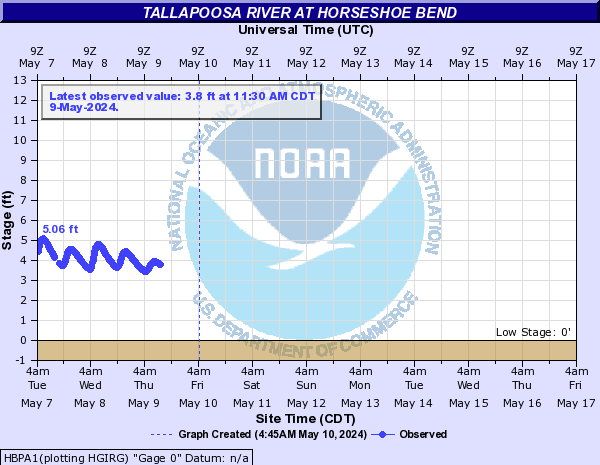
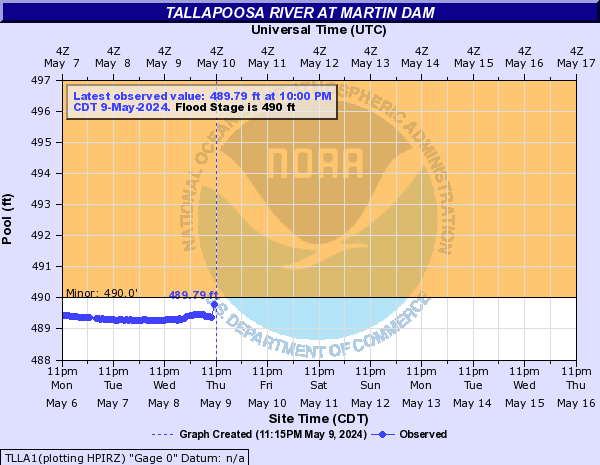
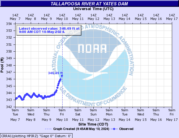
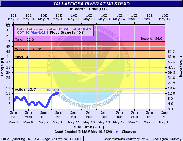
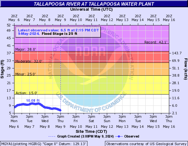
Tallapoosa River (Click on an image to go to hydrograph webpage)
TLAG1:
MHDA1:

WDLA1:
HBPA1:
TLLA1:
CRRA1:
MILA1:
MGYA1:
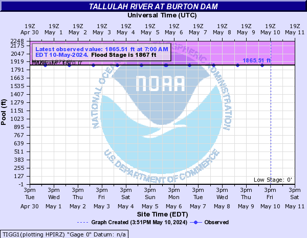
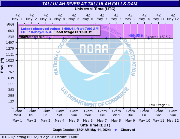
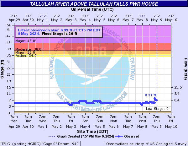
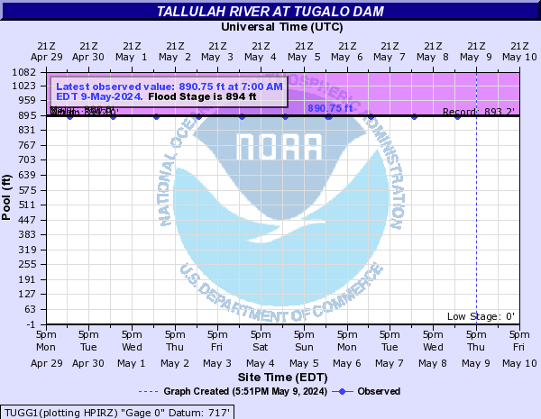
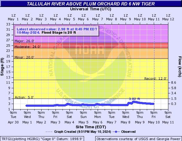
Tallulah River (Click on an image to go to hydrograph webpage)
TIGG1:
NACG1:

TERG1:

TLUG1:
TFLG1:
TUGG1:
TRTG1:
Tanasee Creek (Click on an image to go to hydrograph webpage)
ITCN7:
EFKN7:
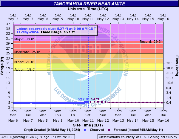
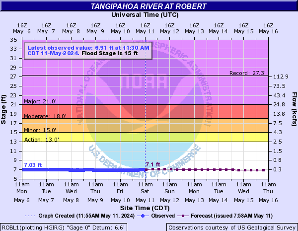
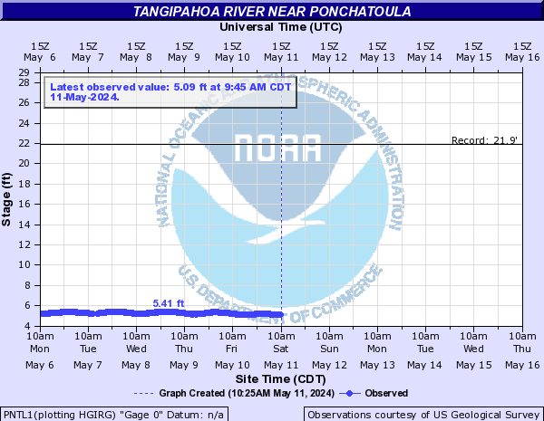
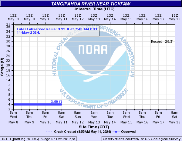
Tangipahoa River (Click on an image to go to hydrograph webpage)
OSYM6:
KENL1:
AMIL1:
ROBL1:
PNTL1:
TRTL1:
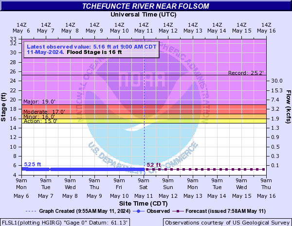
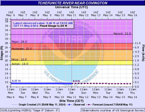
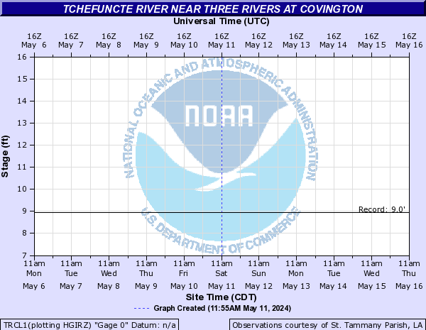
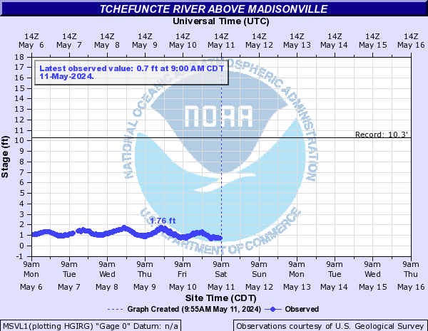
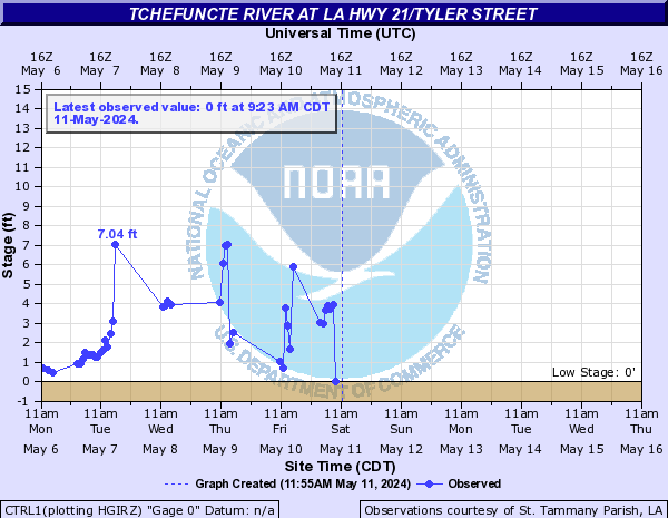
Tchefuncte River (Click on an image to go to hydrograph webpage)
FLSL1:
CUSL1:
TRCL1:
MSVL1:
CTRL1:
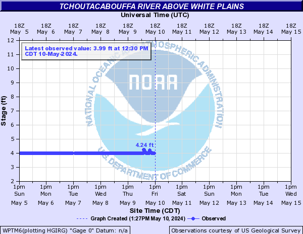
Tchoutacabouffa River (Click on an image to go to hydrograph webpage)
WPTM6:
DIBM6:

Tellico River (Click on an image to go to hydrograph webpage)
TLRT1:

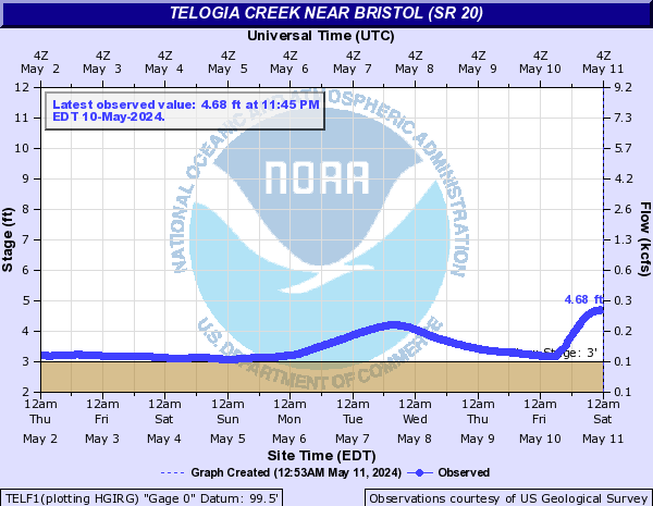
Telogia Creek (Click on an image to go to hydrograph webpage)
TELF1:
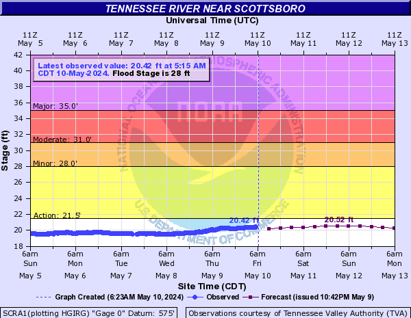
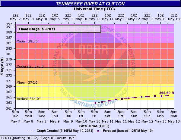
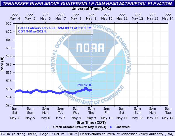
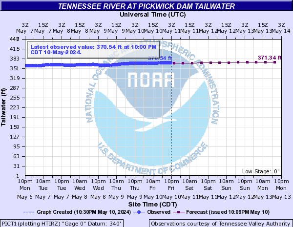
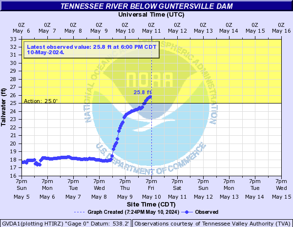
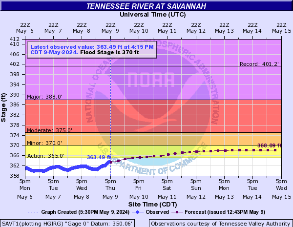
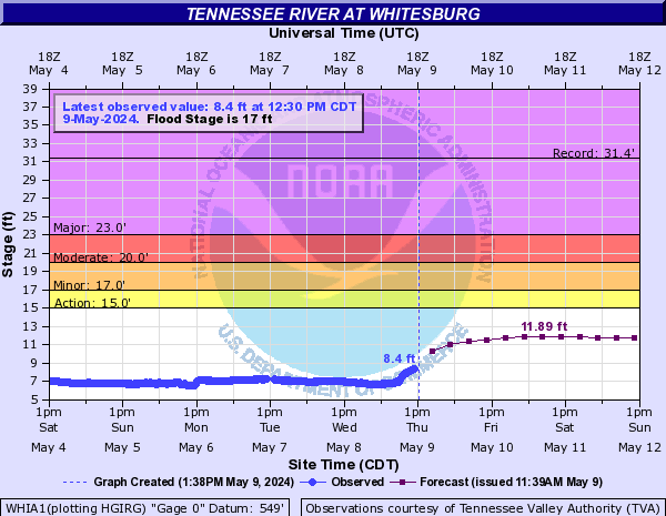
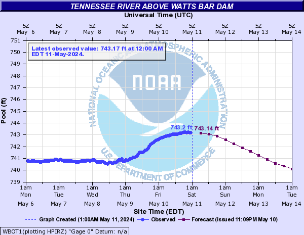
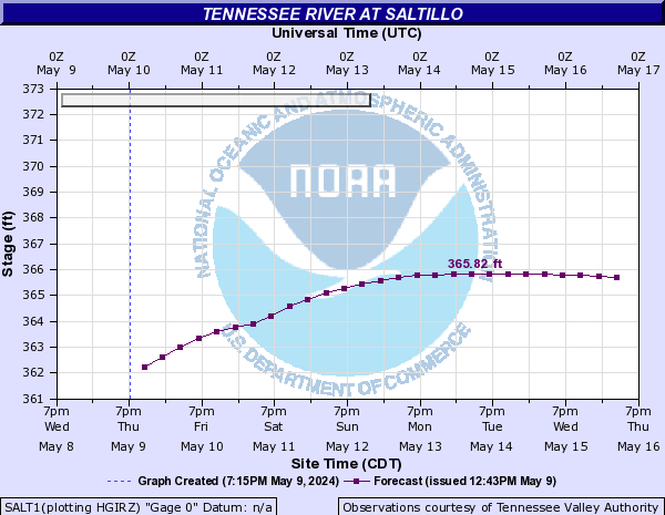
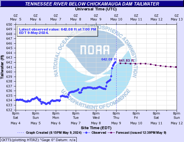
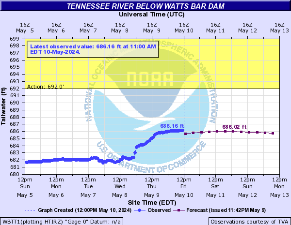
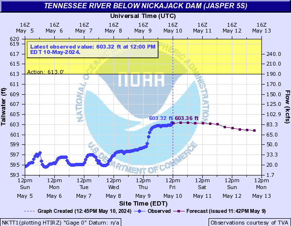
Tennessee River (Click on an image to go to hydrograph webpage)
SCRA1:
CLNT1:
GVHA1:
PICT1:
GVDA1:
SAVT1:
WHIA1:
WBOT1:
SALT1:
DECA1:

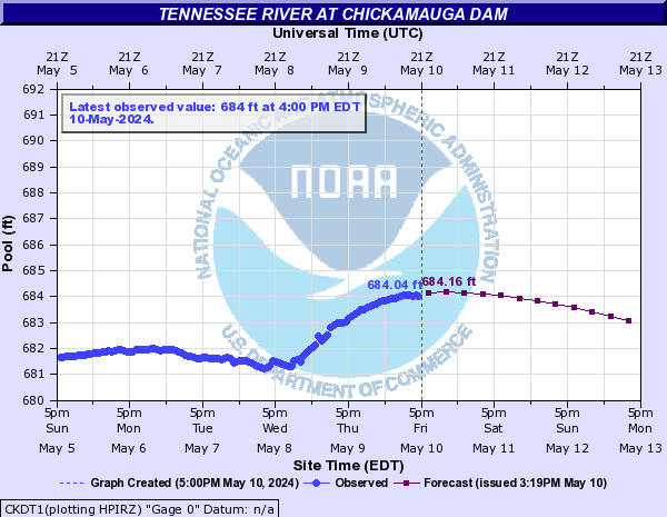
CKDT1:
PRVT1:

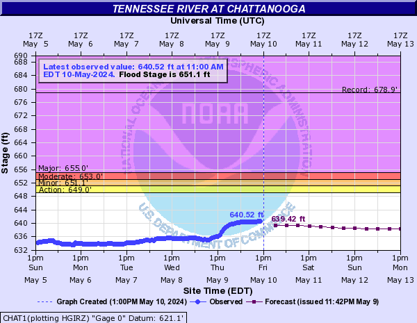
CHAT1:
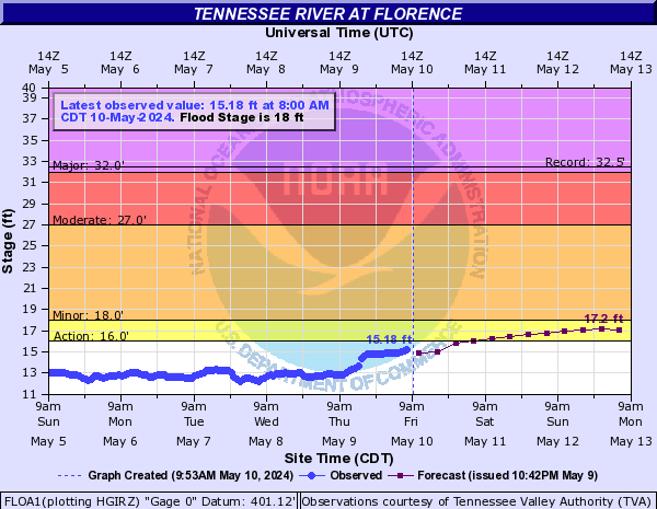
FLOA1:
NKJT1:

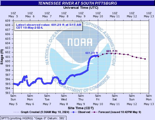
SPTT1:
CKTT1:
WBTT1:
NKTT1:
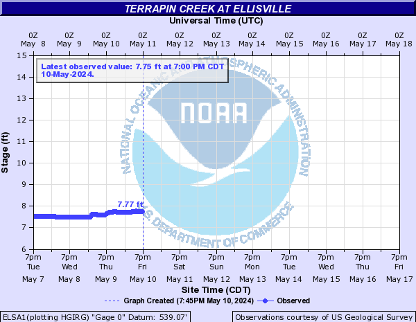
Terrapin Creek (Click on an image to go to hydrograph webpage)
ELSA1:
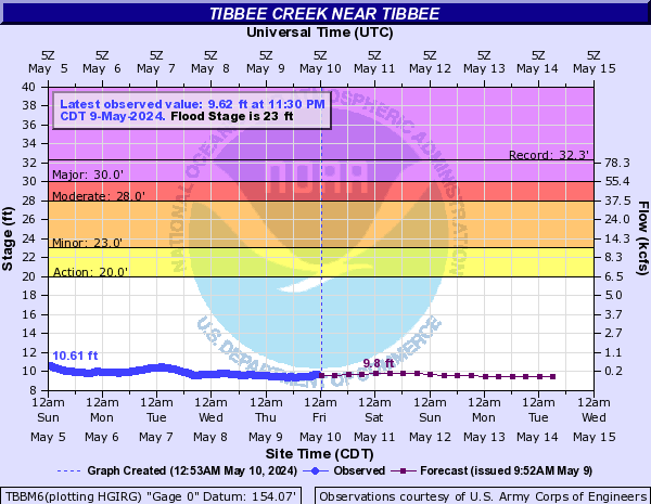
Tibbee Creek (Click on an image to go to hydrograph webpage)
TBBM6:
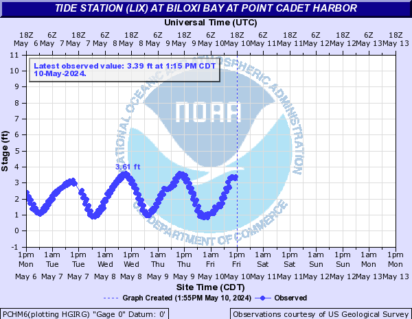
Tide Station (LIX) (Click on an image to go to hydrograph webpage)
PNLM6:

BBBM6:
PCHM6:
WYCM6:
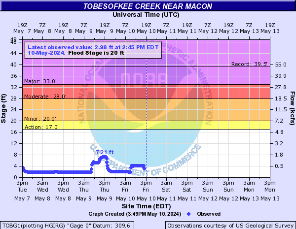
Tobesofkee Creek (Click on an image to go to hydrograph webpage)
TOBG1:
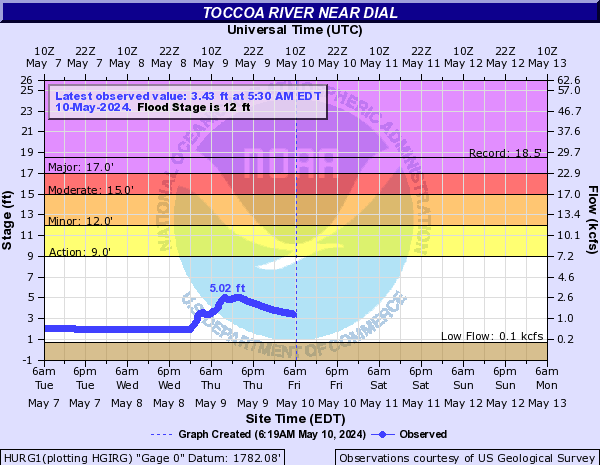
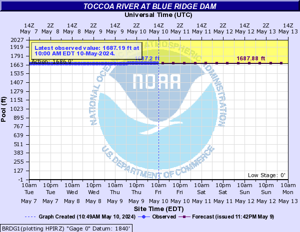
Toccoa River (Click on an image to go to hydrograph webpage)
HURG1:
BRDG1:
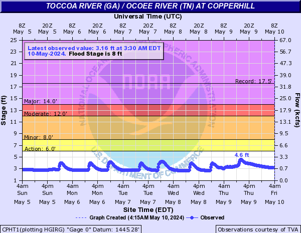
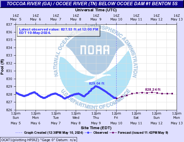
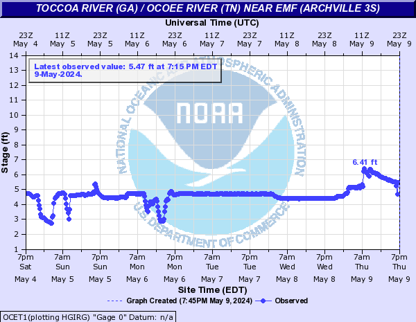
Toccoa River (GA) / Ocoee River (TN) (Click on an image to go to hydrograph webpage)
CPHT1:
OCAT1:
OCET1:
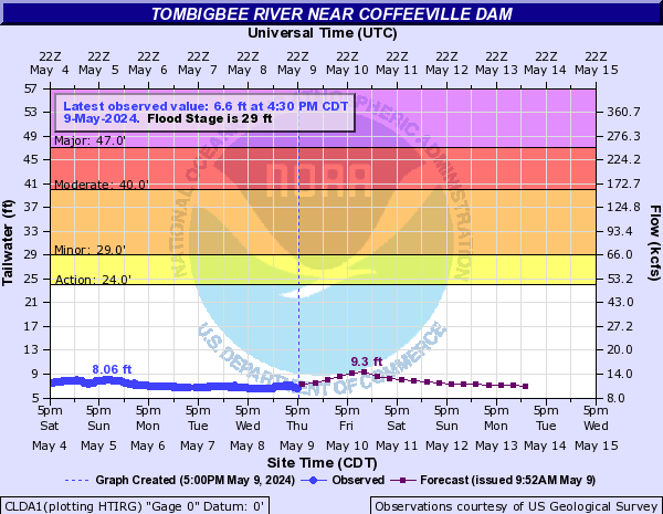
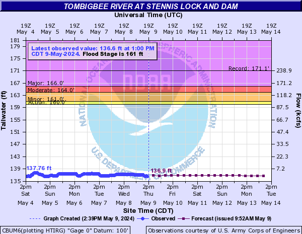
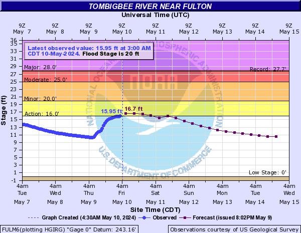
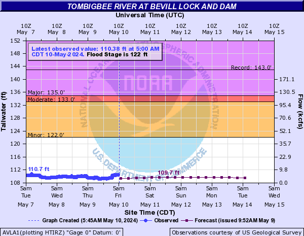
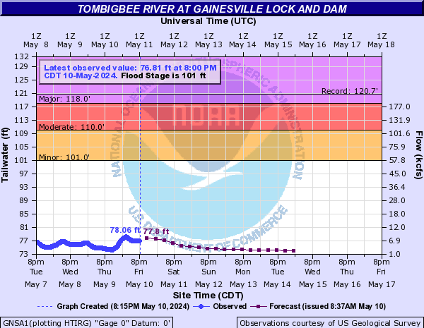
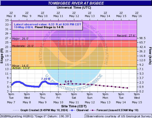
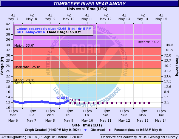
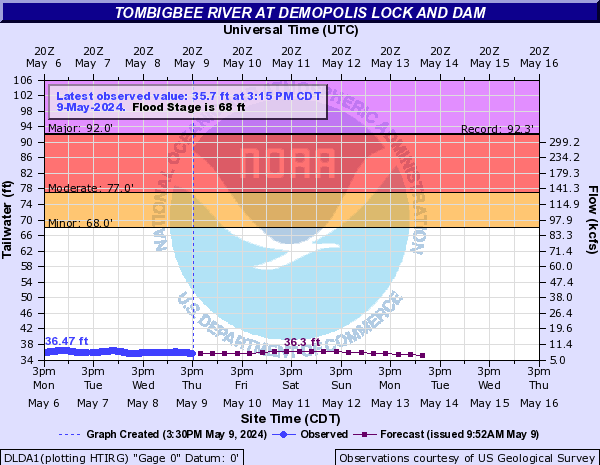
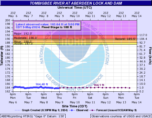
Tombigbee River (Click on an image to go to hydrograph webpage)
CLDA1:
CBUM6:
FULM6:
AVLA1:
LRYA1:

GNSA1:
BGBM6:
AMYM6:
DLDA1:
NANA1:

ABEM6:
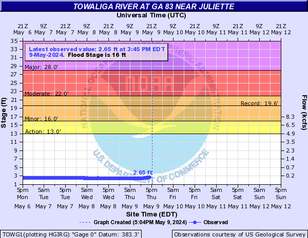
Towaliga River (Click on an image to go to hydrograph webpage)
TOWG1:
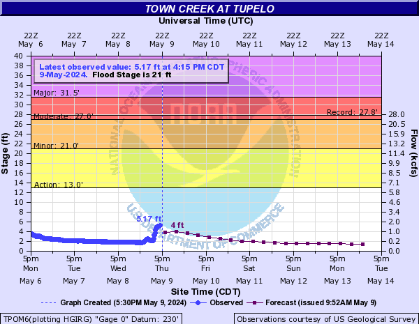
Town Creek (Click on an image to go to hydrograph webpage)
TPOM6:
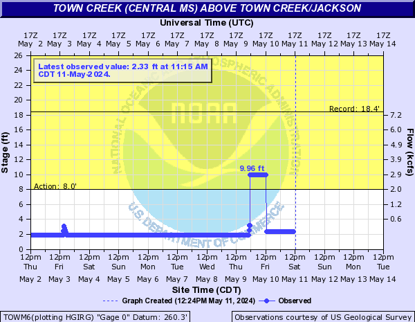
Town Creek (Central MS) (Click on an image to go to hydrograph webpage)
TOWM6:
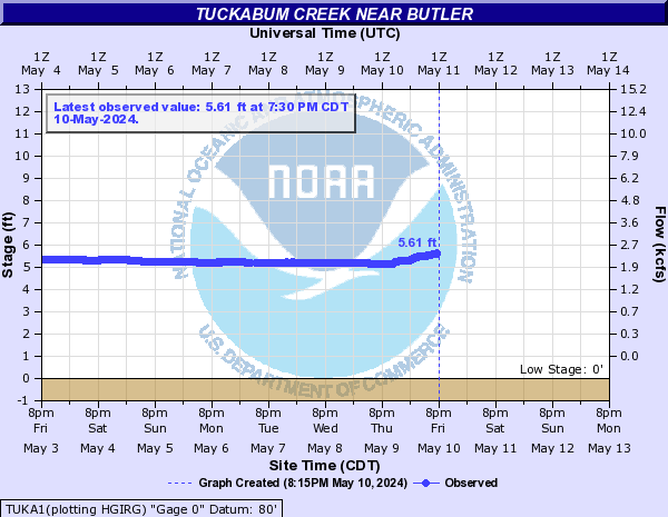
Tuckabum Creek (Click on an image to go to hydrograph webpage)
TUKA1:
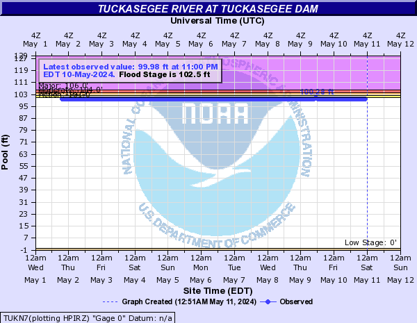
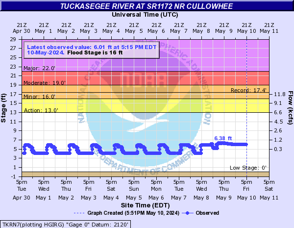
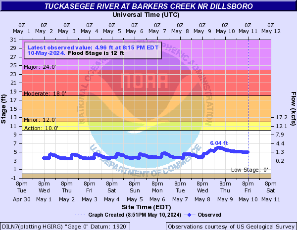
Tuckasegee River (Click on an image to go to hydrograph webpage)
TUKN7:
IRBN7:

TKRN7:
SCTN7:

DILN7:
TKSN7:

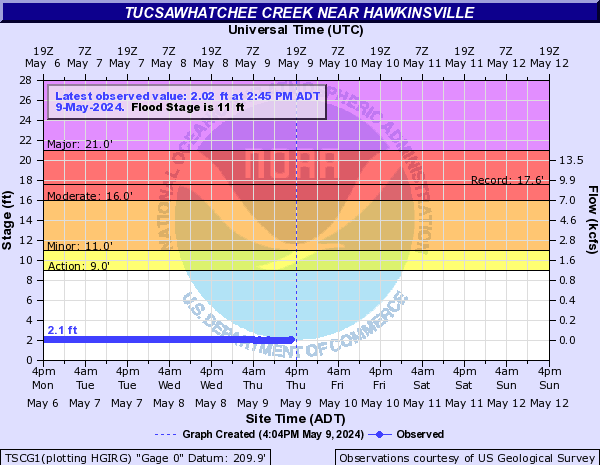
Tucsawhatchee Creek (Click on an image to go to hydrograph webpage)
TSCG1:
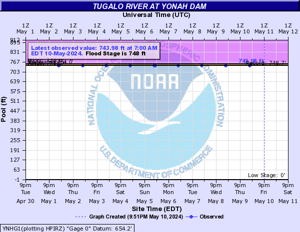
Tugalo River (Click on an image to go to hydrograph webpage)
YNHG1:
Tulula Creek (Click on an image to go to hydrograph webpage)
TULN7:

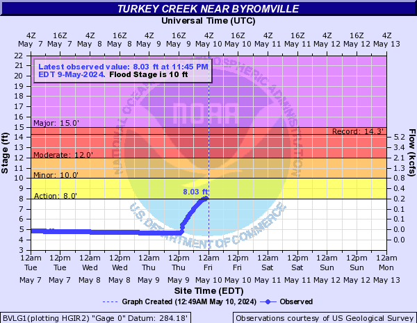
Turkey Creek (Click on an image to go to hydrograph webpage)
BVLG1:
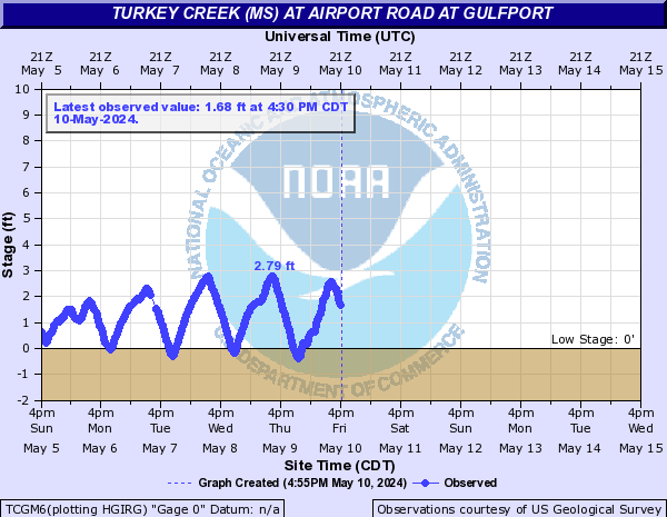
Turkey Creek (MS) (Click on an image to go to hydrograph webpage)
TCGM6:
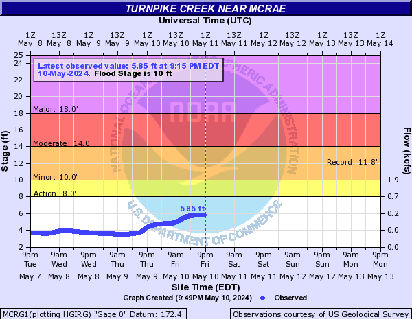
Turnpike Creek (Click on an image to go to hydrograph webpage)
MCRG1:
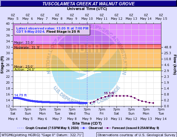
Tuscolameta Creek (Click on an image to go to hydrograph webpage)
WTGM6:
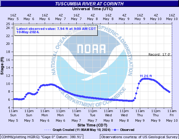
Tuscumbia River (Click on an image to go to hydrograph webpage)
COHM6:
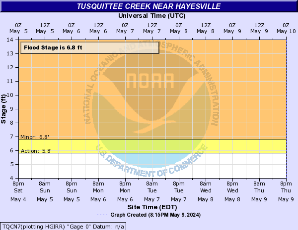
Tusquittee Creek (Click on an image to go to hydrograph webpage)
TQCN7:
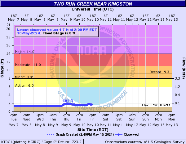
Two Run Creek (Click on an image to go to hydrograph webpage)
KTRG1:
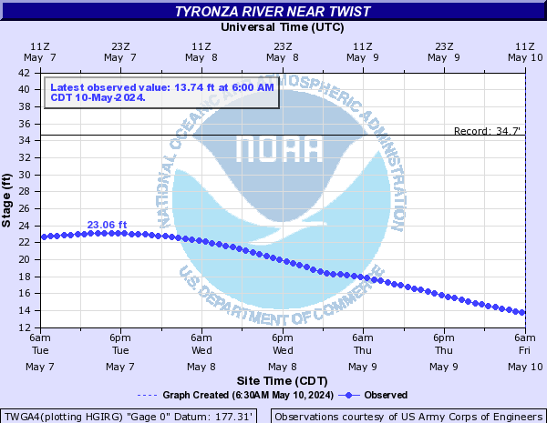
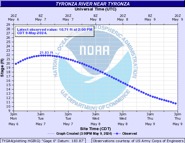
Tyronza River (Click on an image to go to hydrograph webpage)
TWGA4:
TYGA4:
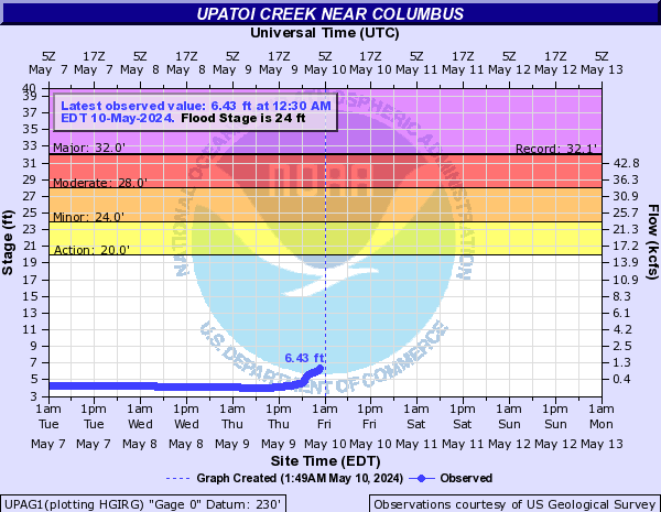
Upatoi Creek (Click on an image to go to hydrograph webpage)
UPAG1:
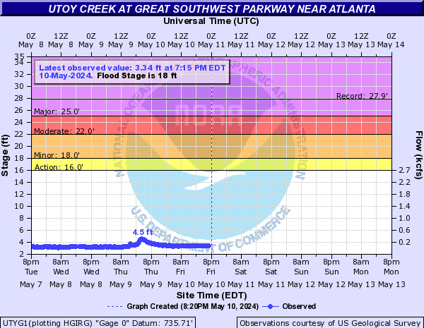
Utoy Creek (Click on an image to go to hydrograph webpage)
UTYG1:
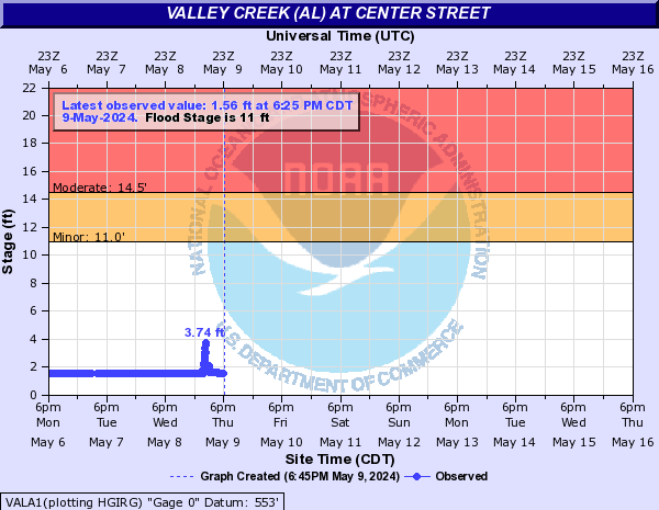
Valley Creek (AL) (Click on an image to go to hydrograph webpage)
VALA1:
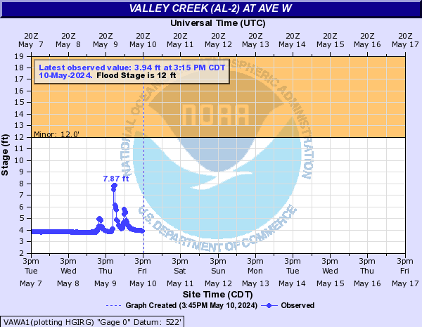
Valley Creek (AL-2) (Click on an image to go to hydrograph webpage)
VAWA1:
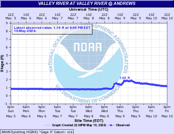
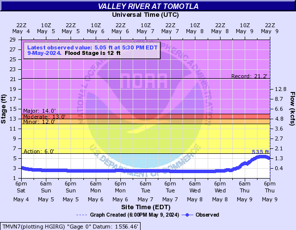
Valley River (Click on an image to go to hydrograph webpage)
ANVN7:
TMVN7:
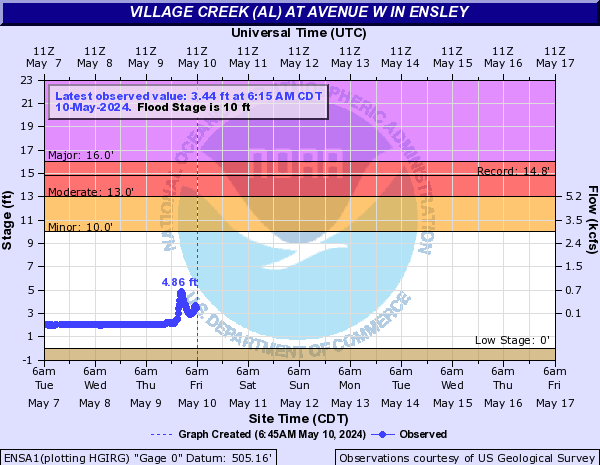
Village Creek (AL) (Click on an image to go to hydrograph webpage)
ENSA1:
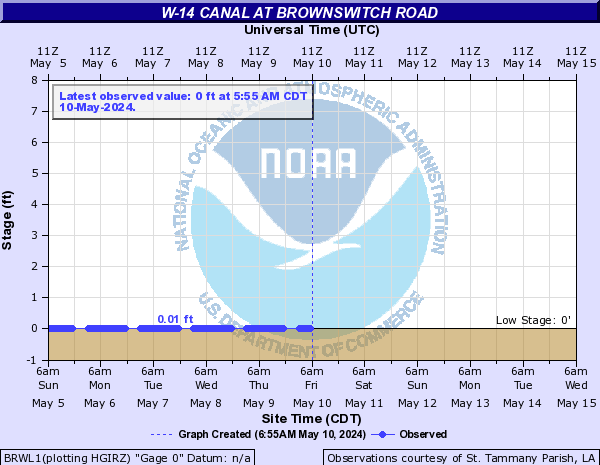
W-14 Canal (Click on an image to go to hydrograph webpage)
BRWL1:
CRBL1:

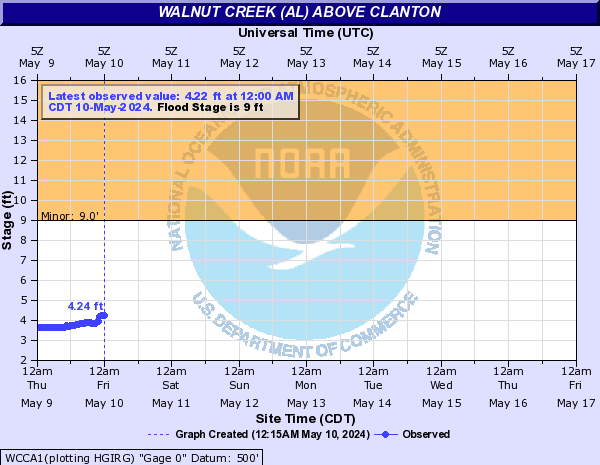
Walnut Creek (AL) (Click on an image to go to hydrograph webpage)
WCCA1:
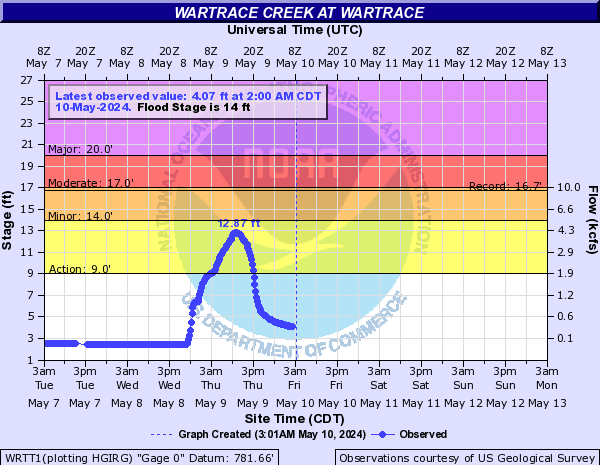
Wartrace Creek (Click on an image to go to hydrograph webpage)
WRTT1:
Watson Creek Tributary (Click on an image to go to hydrograph webpage)
WATG1:

West Chickamauga Creek (Click on an image to go to hydrograph webpage)
WCKG1:

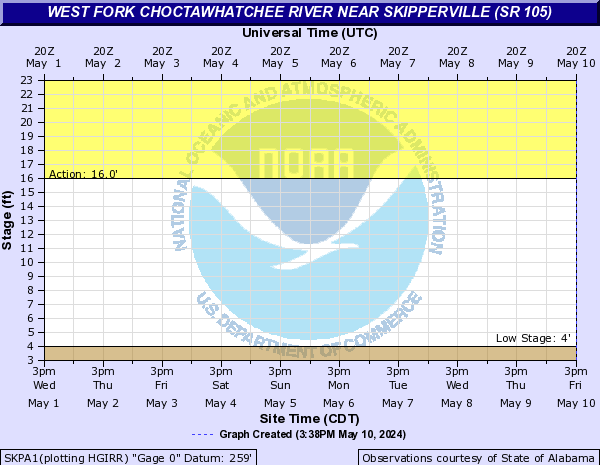
West Fork Choctawhatchee River (Click on an image to go to hydrograph webpage)
SKPA1:
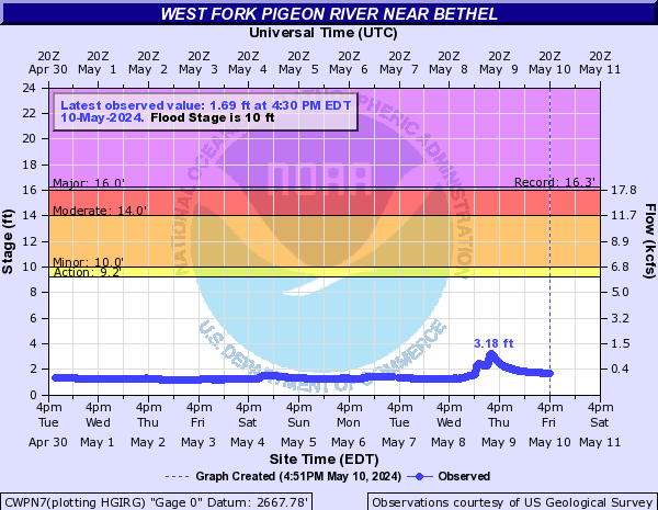
West Fork Pigeon River (Click on an image to go to hydrograph webpage)
CWPN7:
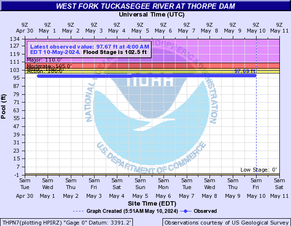
West Fork Tuckasegee River (Click on an image to go to hydrograph webpage)
THPN7:
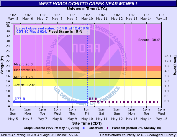
West Hobolochitto Creek (Click on an image to go to hydrograph webpage)
MNLM6:
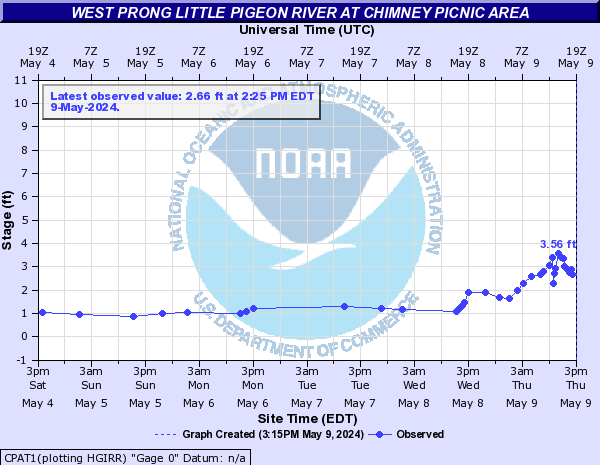
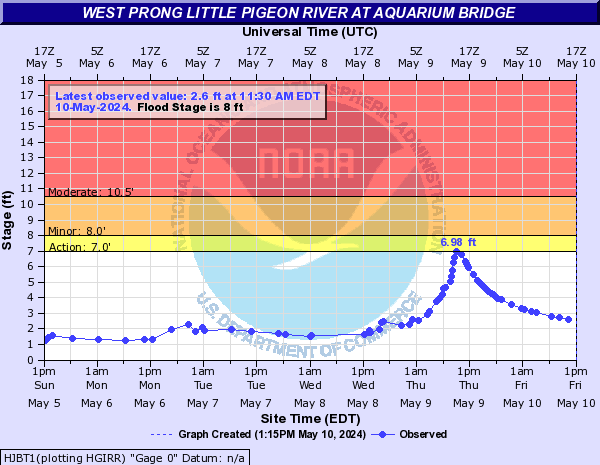
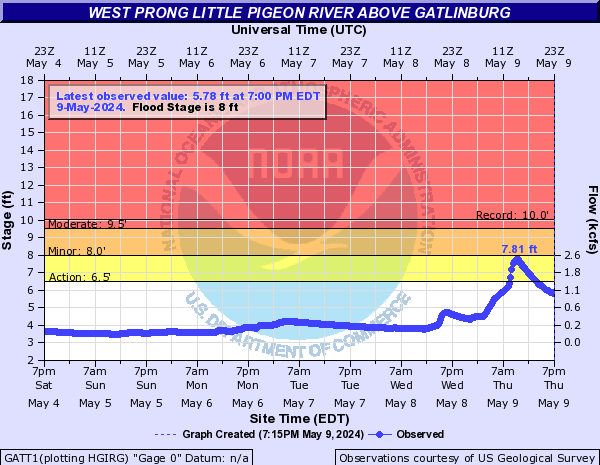
West Prong Little Pigeon River (Click on an image to go to hydrograph webpage)
CPAT1:
HJBT1:
GATT1:
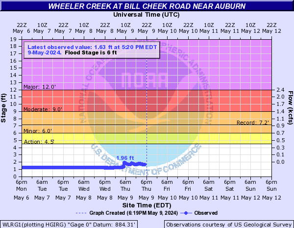
Wheeler Creek (Click on an image to go to hydrograph webpage)
WLRG1:
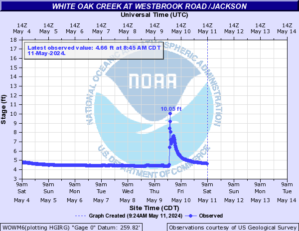
White Oak Creek (Click on an image to go to hydrograph webpage)
WOWM6:
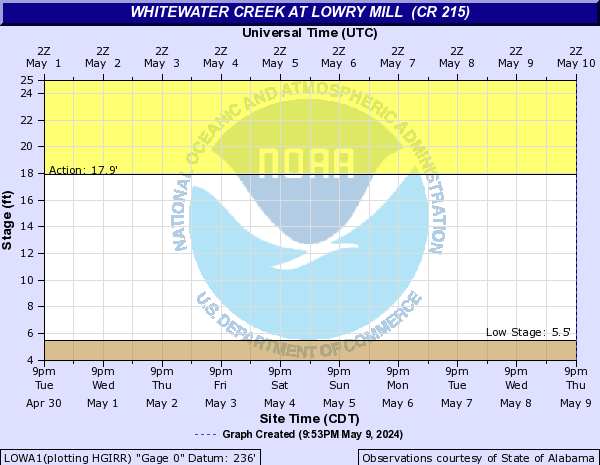
Whitewater Creek (Click on an image to go to hydrograph webpage)
WCEG1:

LOWA1:
WCSG1:

SMFG1:
Wildcat Creek (GA) (Click on an image to go to hydrograph webpage)
WLDG1:

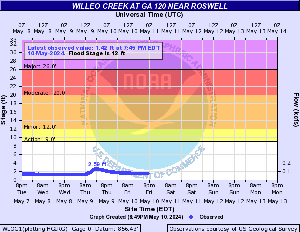
Willeo Creek (Click on an image to go to hydrograph webpage)
WLOG1:
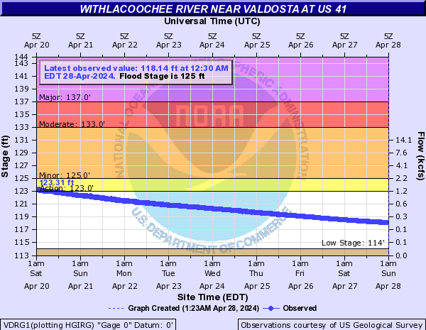
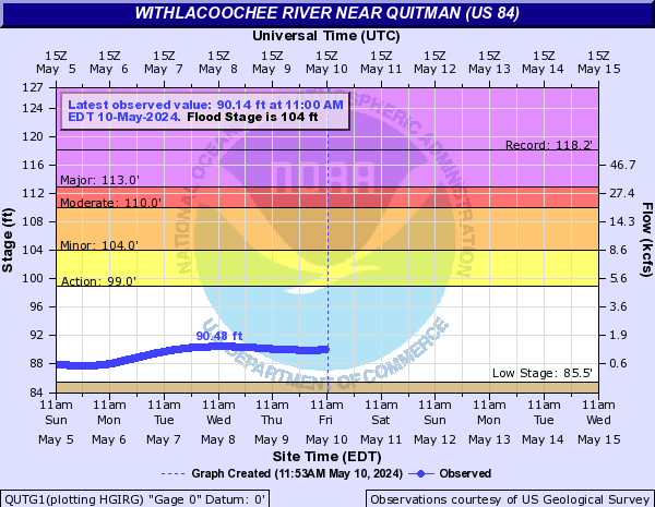
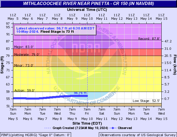
Withlacoochee River (Click on an image to go to hydrograph webpage)
VDSG1:

VDRG1:
QUTG1:
PINF1:
WTMF1:

WTHF1:

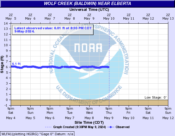
Wolf Creek (Baldwin) (Click on an image to go to hydrograph webpage)
WLFA1:
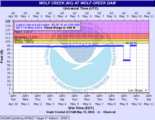
Wolf Creek (NC) (Click on an image to go to hydrograph webpage)
IWCN7:

WCDN7:
Wolf Creek Tributary (Click on an image to go to hydrograph webpage)
WLFG1:

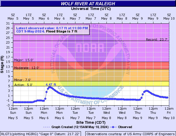
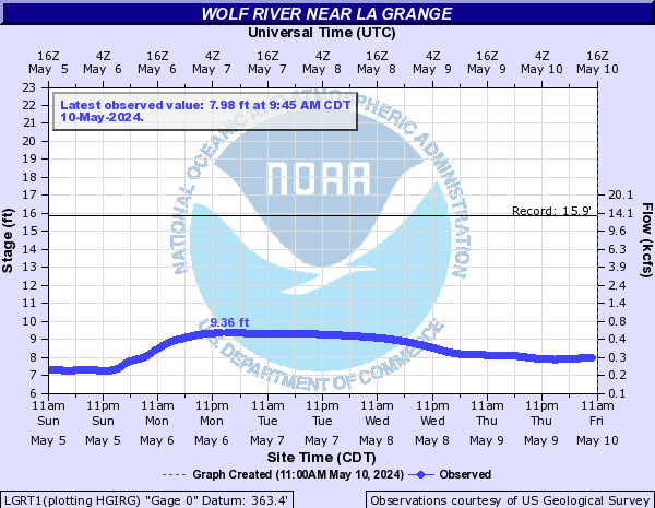
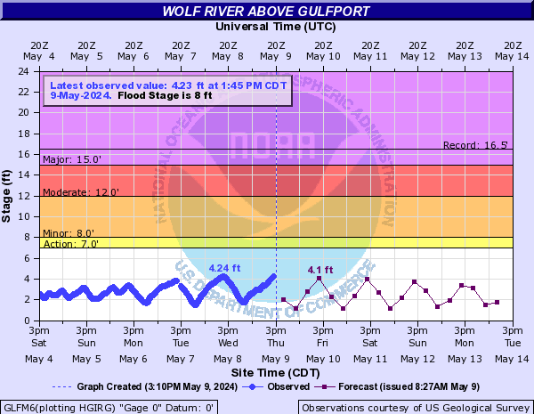
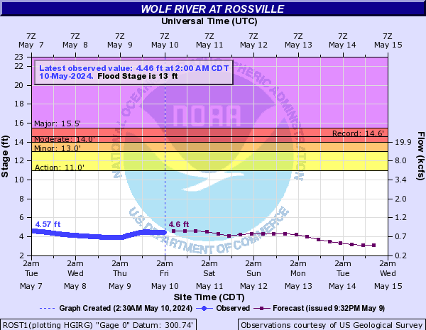
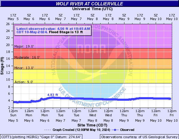
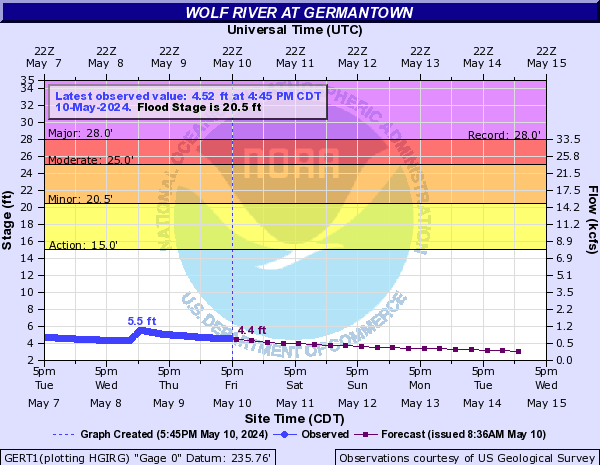
Wolf River (Click on an image to go to hydrograph webpage)
LNDM6:

RLGT1:
LGRT1:
GLFM6:
ROST1:
COTT1:
GERT1:
Wolftever Creek (Click on an image to go to hydrograph webpage)
WFCT1:

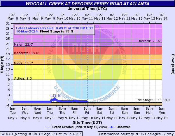
Woodall Creek (Click on an image to go to hydrograph webpage)
WDCG1:
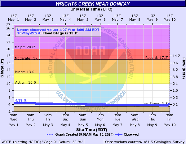
Wrights Creek (Click on an image to go to hydrograph webpage)
WRTF1:
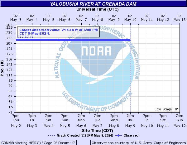
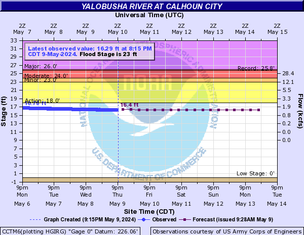
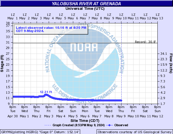
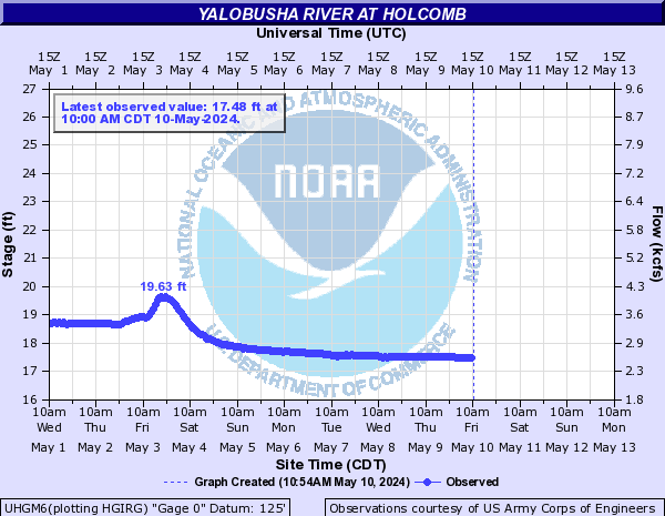
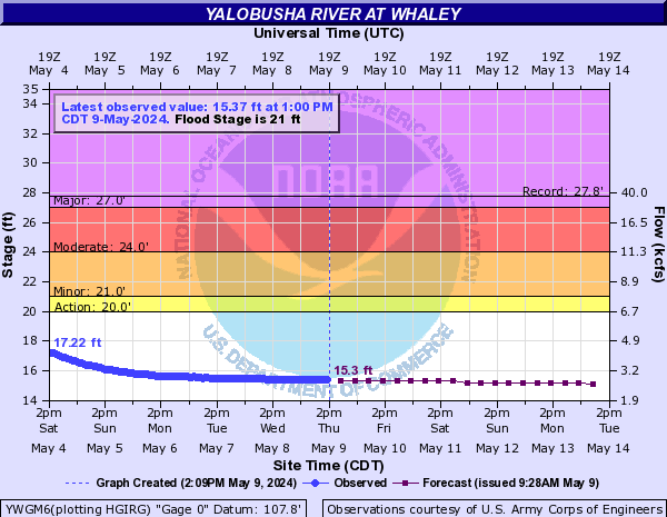
Yalobusha River (Click on an image to go to hydrograph webpage)
GRNM6:
CCTM6:
GRYM6:
UHGM6:
YWGM6:
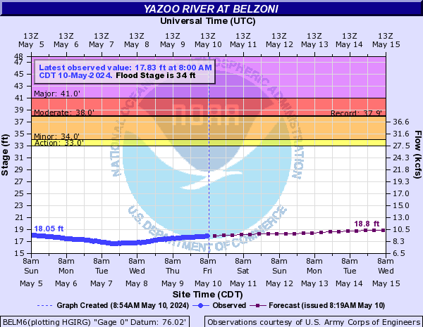
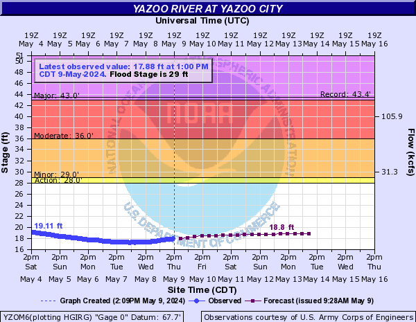
Yazoo River (Click on an image to go to hydrograph webpage)
GREM6:

BELM6:
YZOM6:
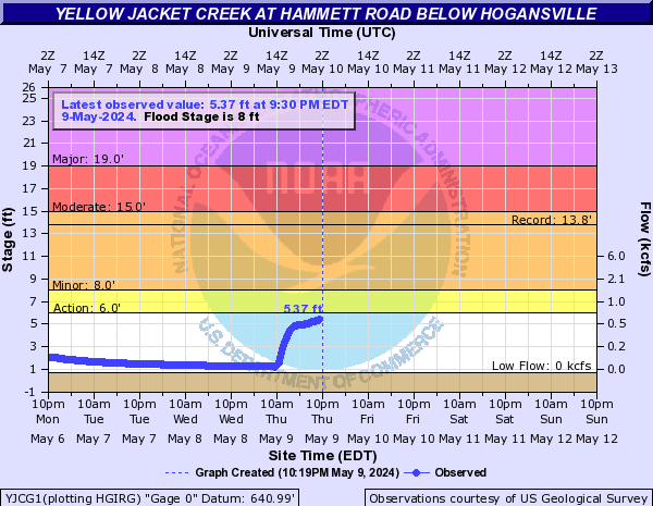
Yellow Jacket Creek (Click on an image to go to hydrograph webpage)
YJCG1:
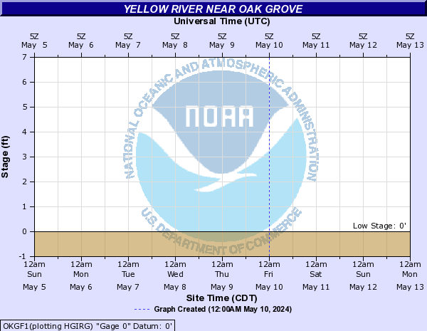
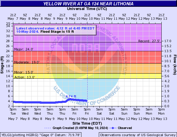
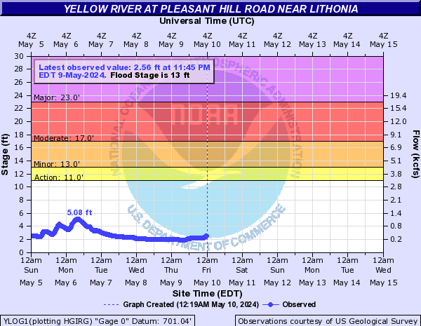
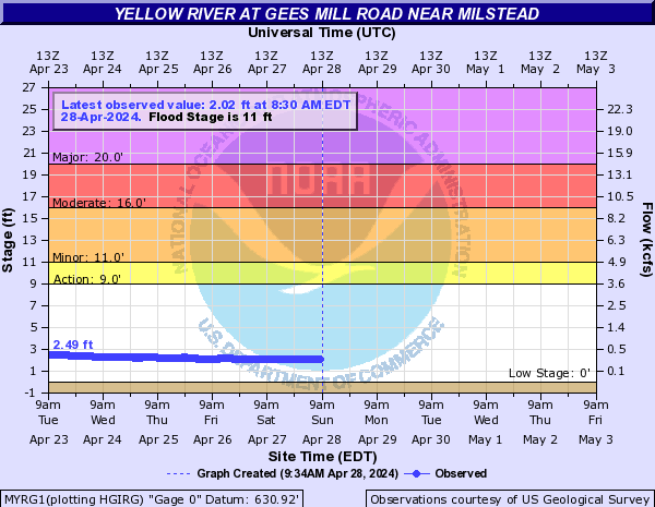
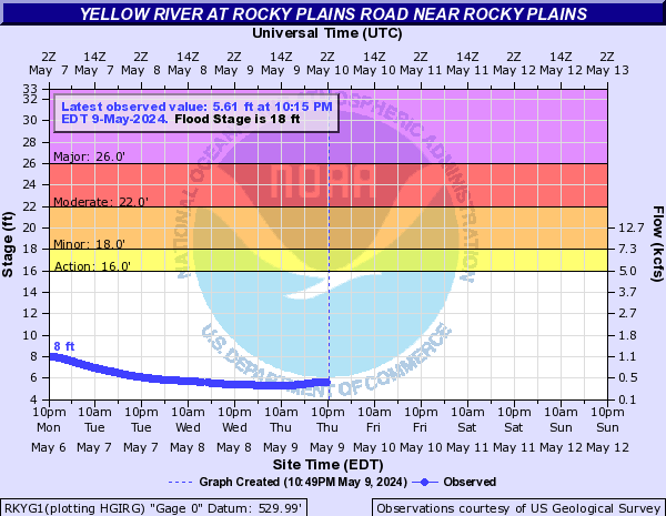
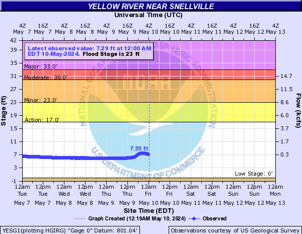
Yellow River (Click on an image to go to hydrograph webpage)
OKGF1:
YELG1:
YLOG1:
MYRG1:
RKYG1:
YESG1:
MSDG1:

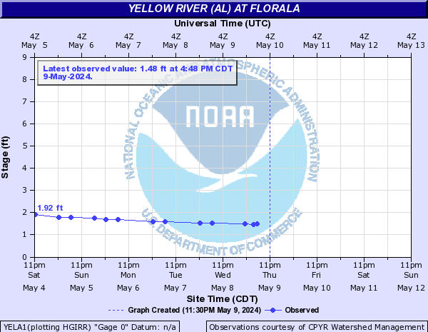
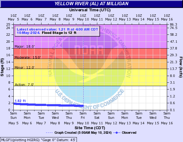
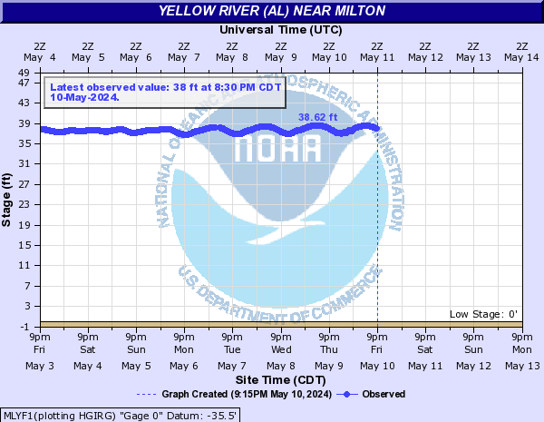
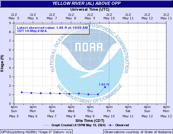
Yellow River (AL) (Click on an image to go to hydrograph webpage)
YELA1:
MLGF1:
MLYF1:
OPYA1:
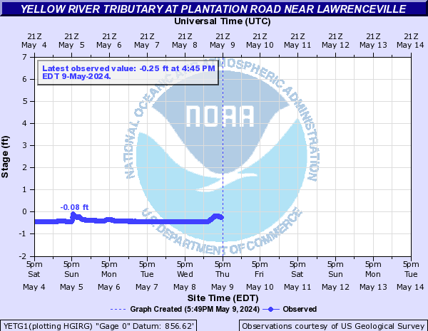
Yellow River Tributary (Click on an image to go to hydrograph webpage)
YETG1:
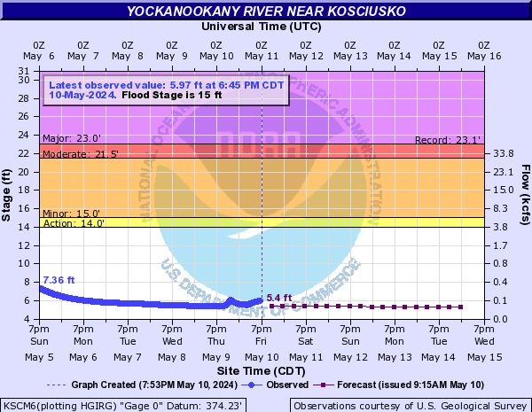
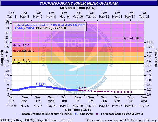
Yockanookany River (Click on an image to go to hydrograph webpage)
KSCM6:
OFAM6:
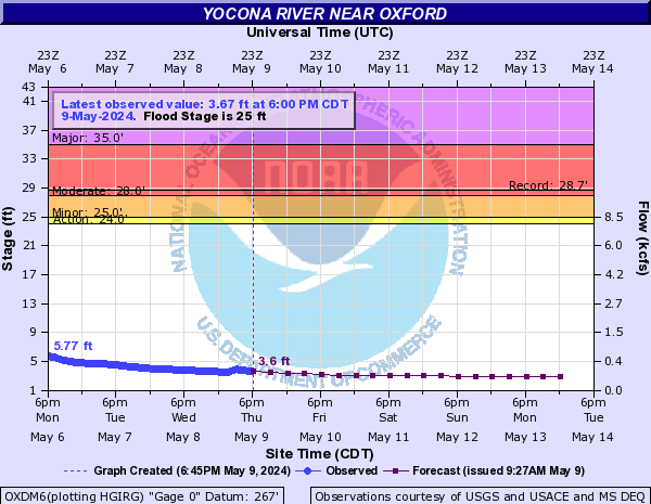
Yocona River (Click on an image to go to hydrograph webpage)
OXDM6:
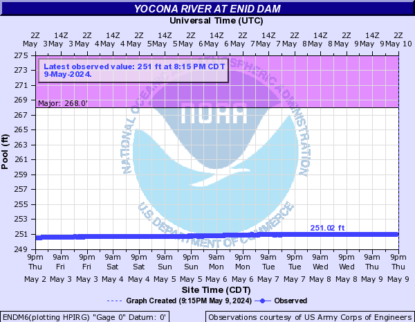
ENDM6: