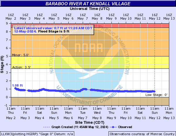
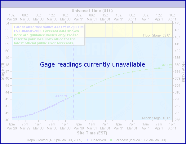
Baraboo River (Click on an image to go to hydrograph webpage)
LLXW3:
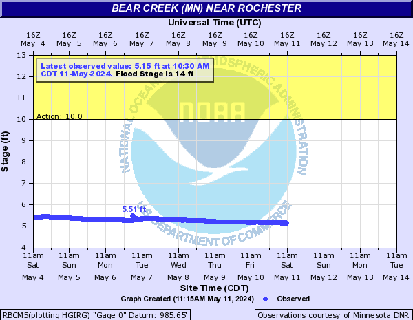
Bear Creek (MN) (Click on an image to go to hydrograph webpage)
RBCM5:
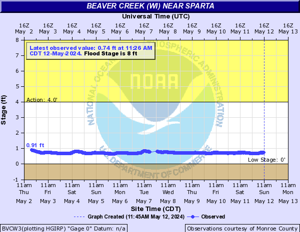
Beaver Creek (WI) (Click on an image to go to hydrograph webpage)
BVCW3:
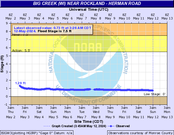
Big Creek (WI) (Click on an image to go to hydrograph webpage)
BIGW3:
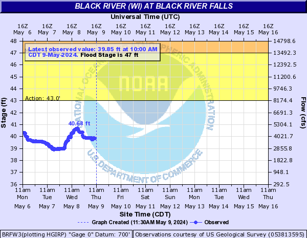
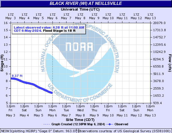
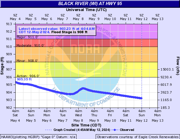
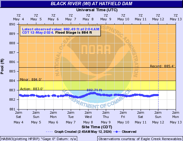
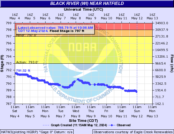
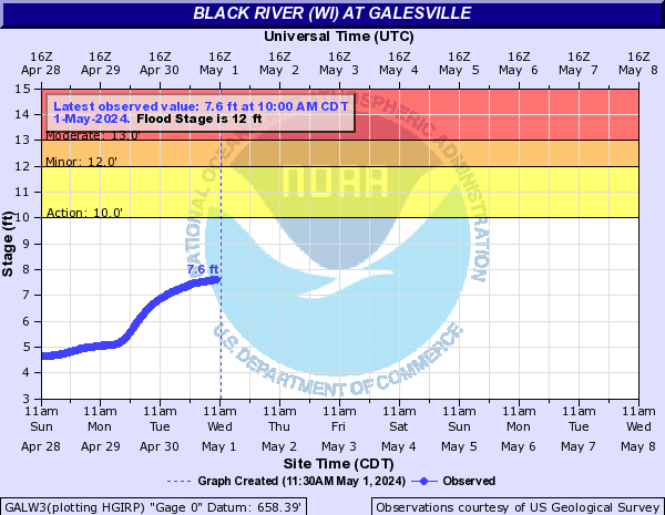
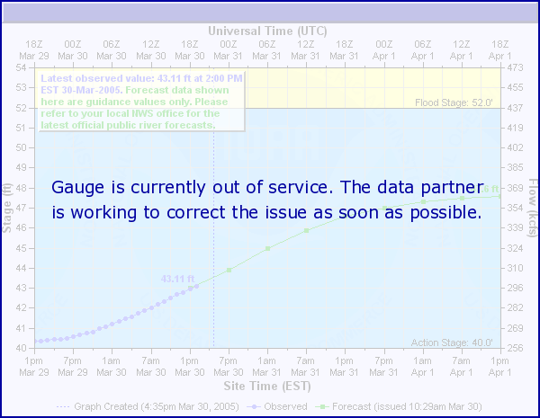
Black River (WI) (Click on an image to go to hydrograph webpage)
BRFW3:
NEIW3:
HAAW3:
HABW3:
HATW3:
GALW3:
Brockcamp Creek (Click on an image to go to hydrograph webpage)
FSTI4:

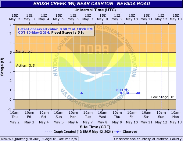
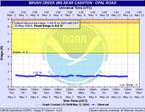
Brush Creek (WI) (Click on an image to go to hydrograph webpage)
RNOW3:
OBCW3:
Cannon Valley Creek (Click on an image to go to hydrograph webpage)
MNNW3:

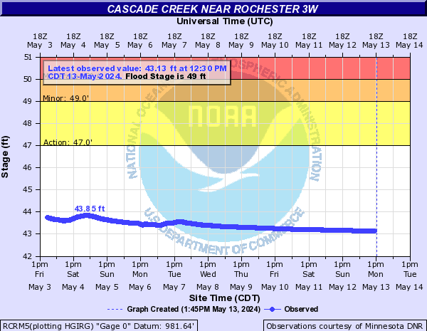
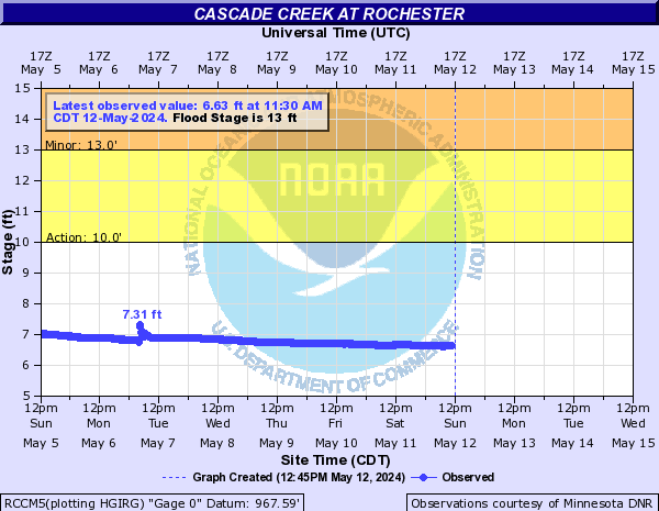
Cascade Creek (Click on an image to go to hydrograph webpage)
RCRM5:
RCCM5:
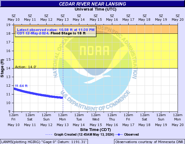
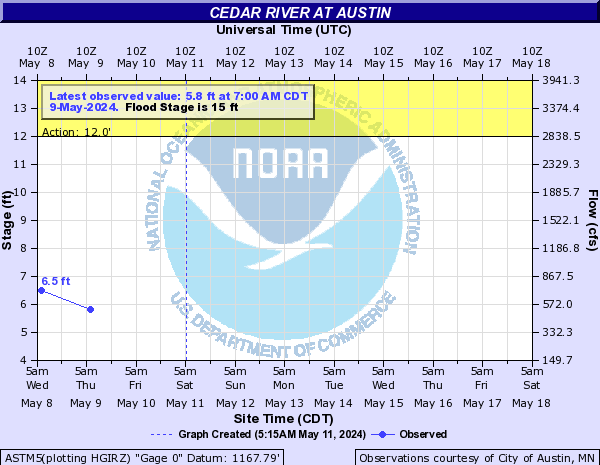
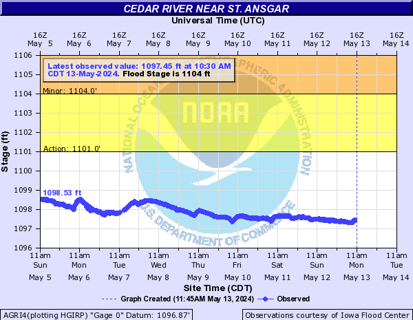
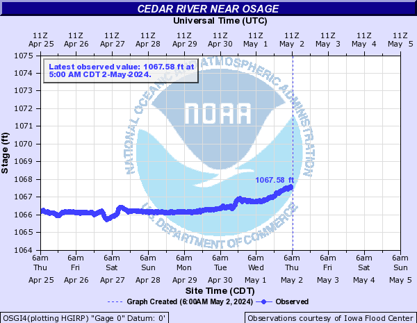
Cedar River (Click on an image to go to hydrograph webpage)
LANM5:
ASTM5:
OTRI4:

AGRI4:
OSGI4:
CCYI4:

ASNM5:

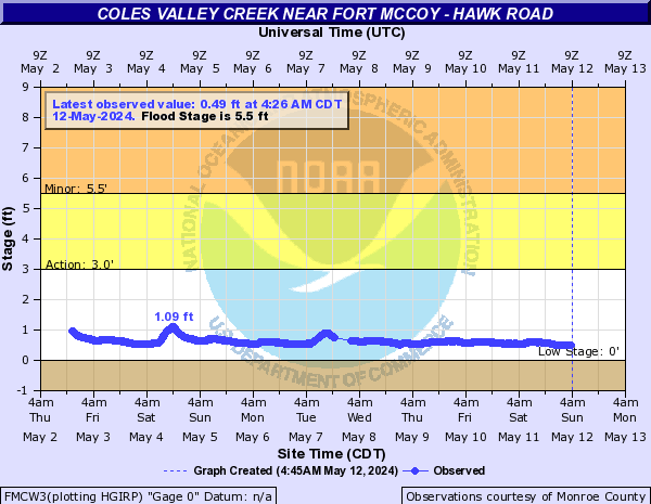
Coles Valley Creek (Click on an image to go to hydrograph webpage)
FMCW3:
Cook Creek (Click on an image to go to hydrograph webpage)
COOW3:

Creek 22-15 (Click on an image to go to hydrograph webpage)
JLNW3:

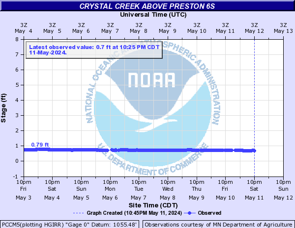
Crystal Creek (Click on an image to go to hydrograph webpage)
PCCM5:
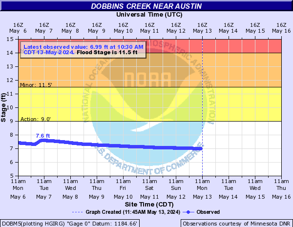
Dobbins Creek (Click on an image to go to hydrograph webpage)
DOBM5:
Dry Run Creek (IA) (Click on an image to go to hydrograph webpage)
DRCI4:

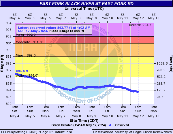
East Fork Black River (Click on an image to go to hydrograph webpage)
HEFW3:
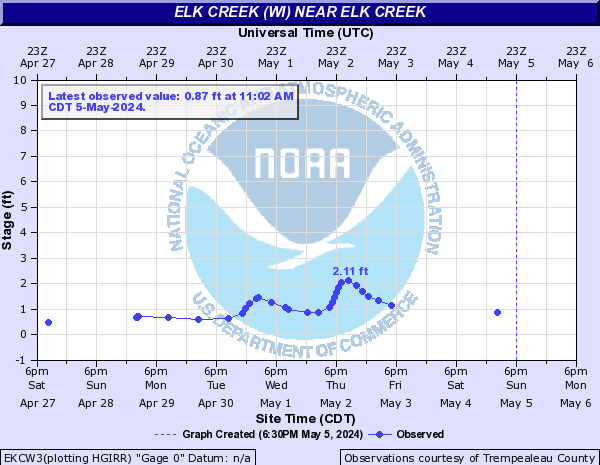
Elk Creek (WI) (Click on an image to go to hydrograph webpage)
EKCW3:
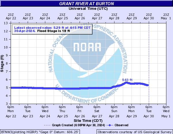
Grant River (Click on an image to go to hydrograph webpage)
BTNW3:
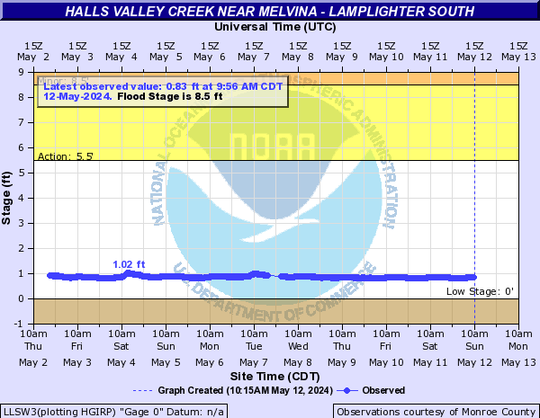
Halls Valley Creek (Click on an image to go to hydrograph webpage)
LLSW3:
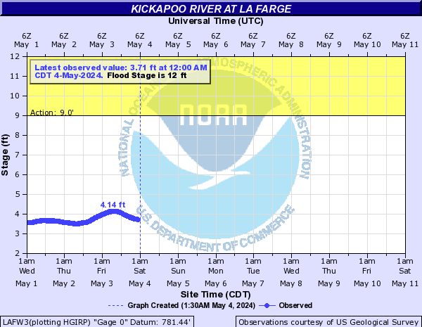
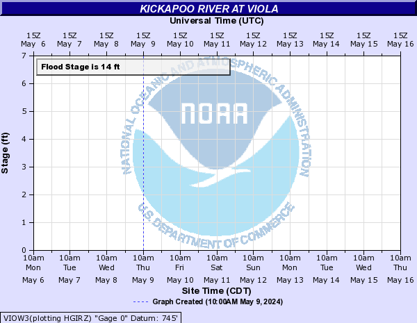
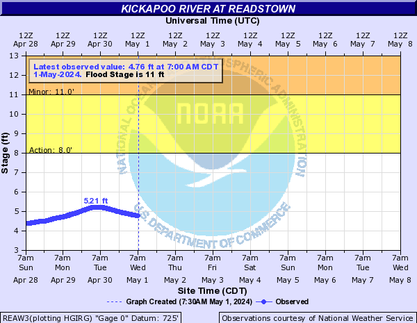
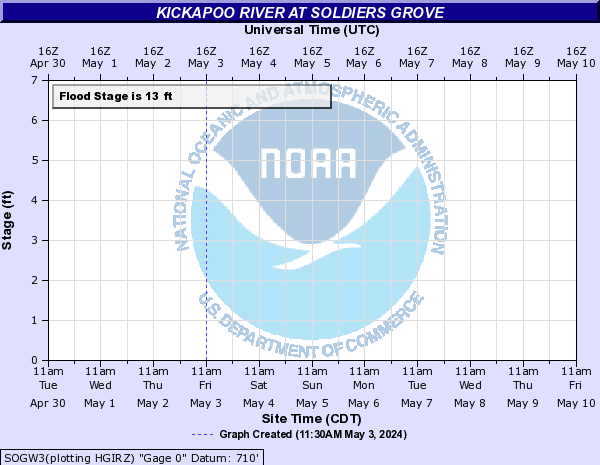
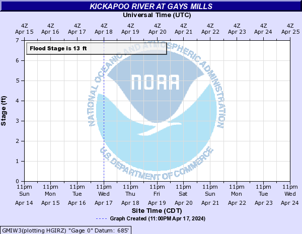
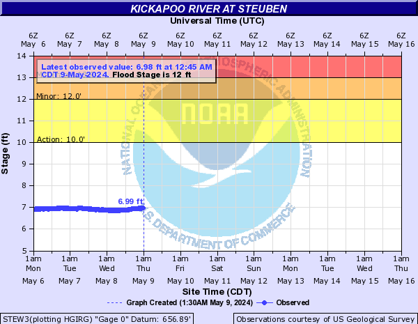
Kickapoo River (Click on an image to go to hydrograph webpage)
ONTW3:

LAFW3:
VIOW3:
REAW3:
SOGW3:
GMIW3:
STEW3:
WKLW3:
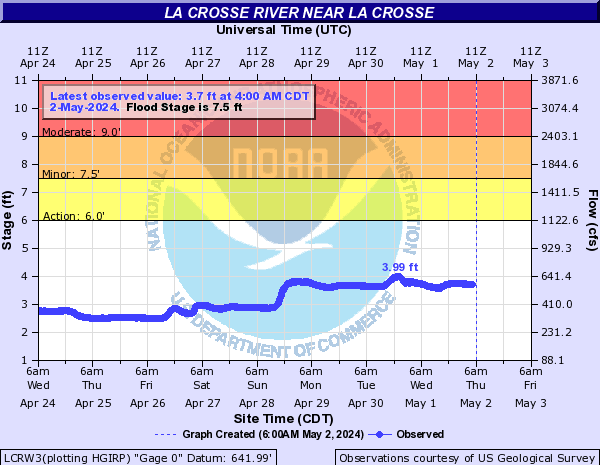
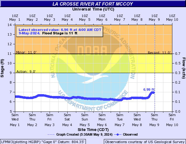
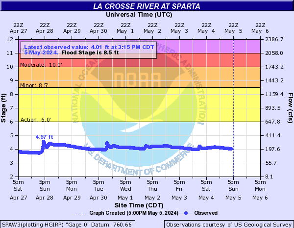
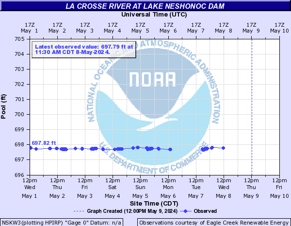
La Crosse River (Click on an image to go to hydrograph webpage)
LCRW3:
LFMW3:
SPAW3:
NSKW3:
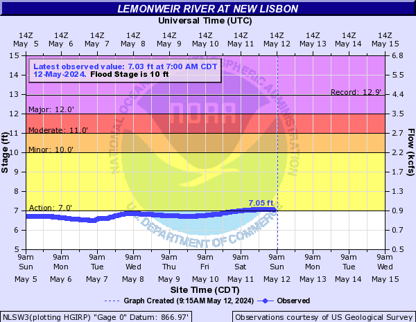
Lemonweir River (Click on an image to go to hydrograph webpage)
NLSW3:
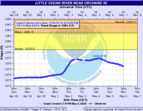
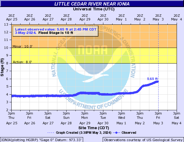
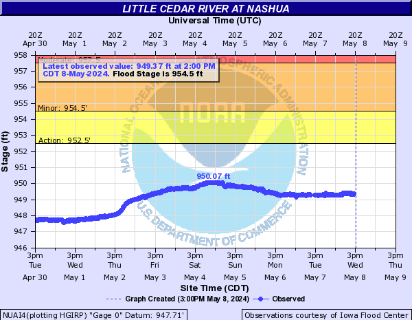
Little Cedar River (Click on an image to go to hydrograph webpage)
LCOI4:
IONI4:
NUAI4:
Little La Crosse River (Click on an image to go to hydrograph webpage)
MLVW3:

LENW3:

CFMW3:

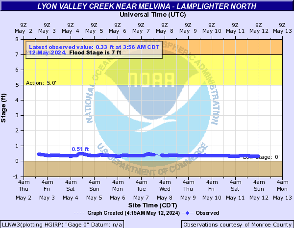
Lyon Valley Creek (Click on an image to go to hydrograph webpage)
LLNW3:
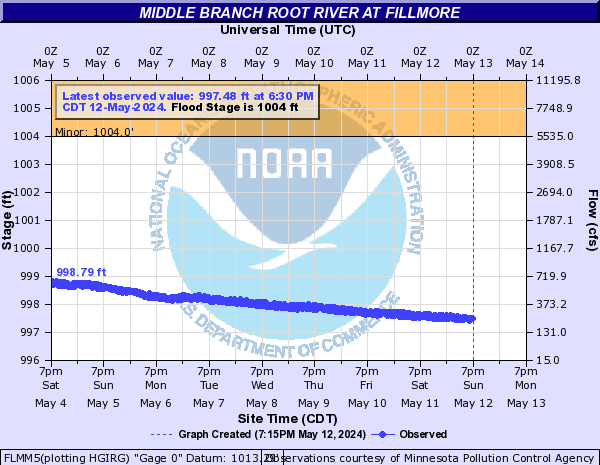
Middle Branch Root River (Click on an image to go to hydrograph webpage)
FLMM5:
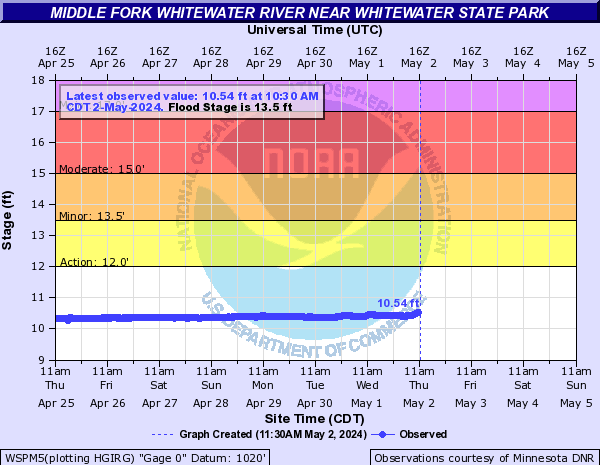
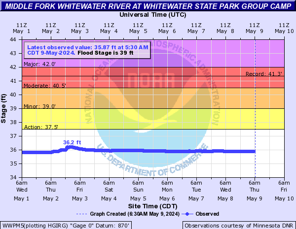
Middle Fork Whitewater River (Click on an image to go to hydrograph webpage)
WSPM5:
WWPM5:
Middle Fork Zumbro River (Click on an image to go to hydrograph webpage)
BNEM5:

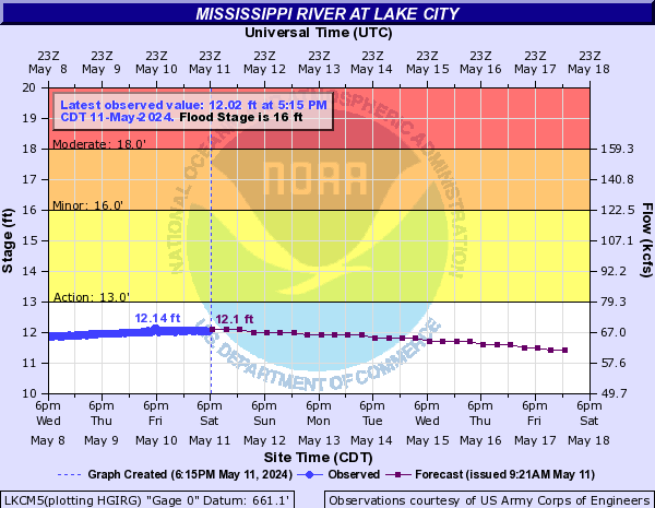
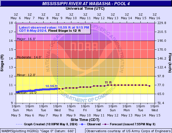
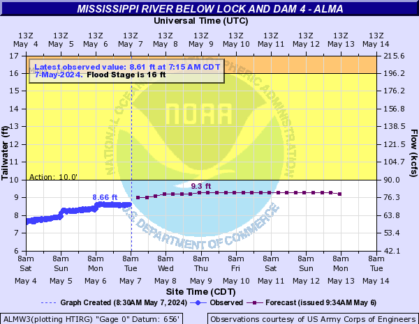
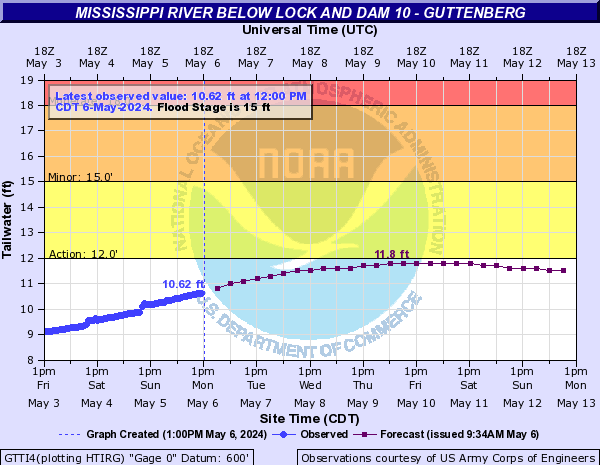
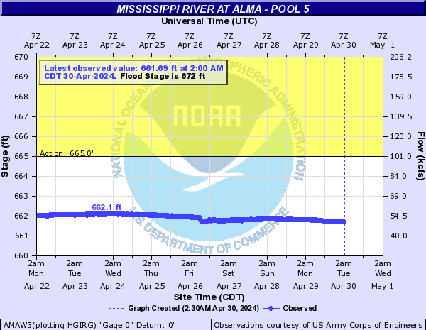
Mississippi River (Click on an image to go to hydrograph webpage)
LKCM5:
WABM5:
ALMW3:
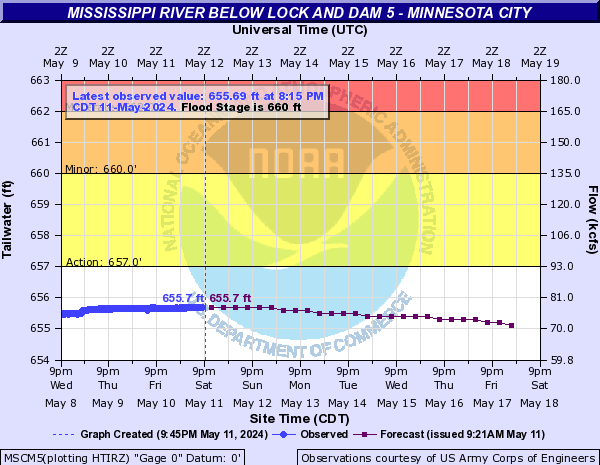
MSCM5:
WIDM5:

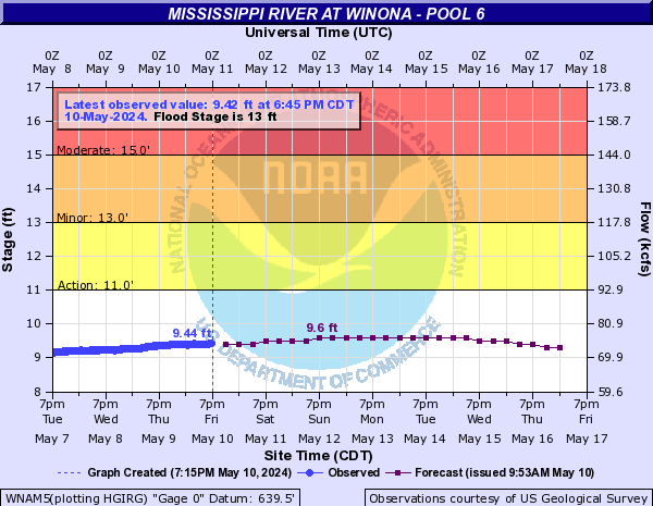
WNAM5:
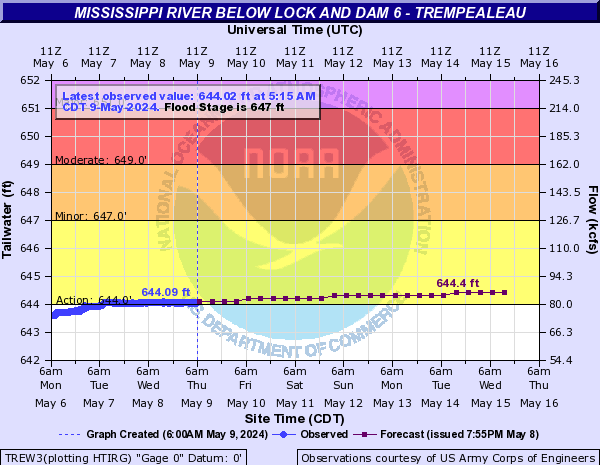
TREW3:
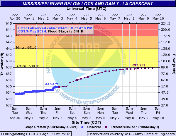
LCRM5:
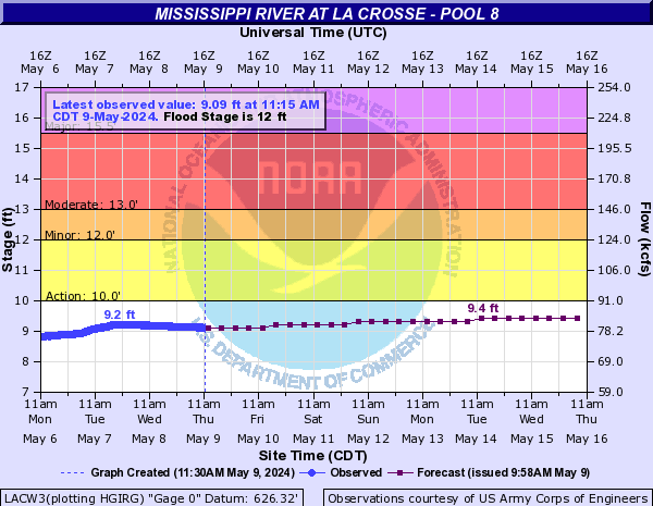
LACW3:
GENW3:

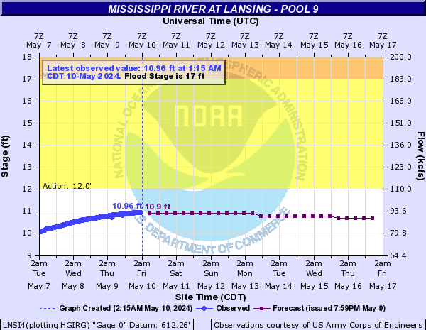
LNSI4:
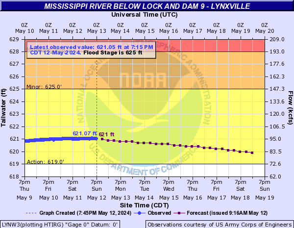
LYNW3:
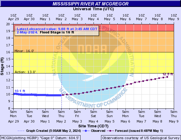
MCGI4:
GTTI4:
AMAW3:
Moore Creek (Click on an image to go to hydrograph webpage)
OCYW3:

NWKW3:

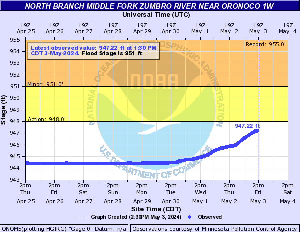
North Branch Middle Fork Zumbro River (Click on an image to go to hydrograph webpage)
ONOM5:
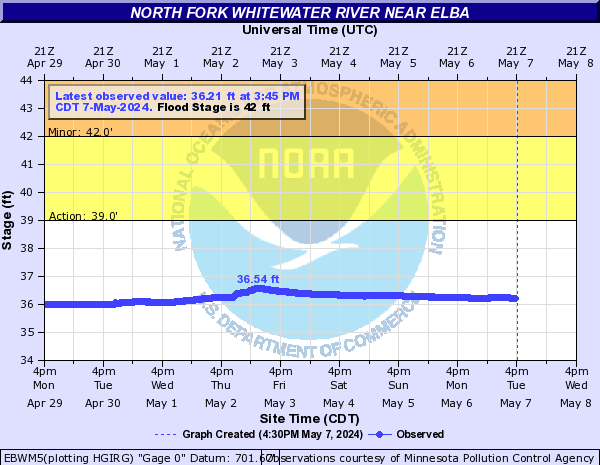
North Fork Whitewater River (Click on an image to go to hydrograph webpage)
EBWM5:
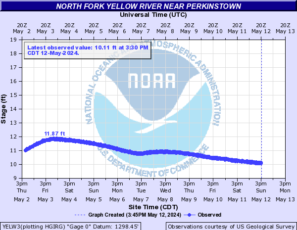
North Fork Yellow River (Click on an image to go to hydrograph webpage)
YELW3:
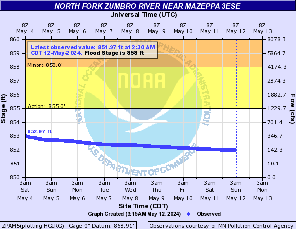
North Fork Zumbro River (Click on an image to go to hydrograph webpage)
ZPAM5:
MAZM5:

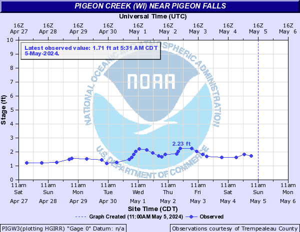
Pigeon Creek (WI) (Click on an image to go to hydrograph webpage)
PIGW3:
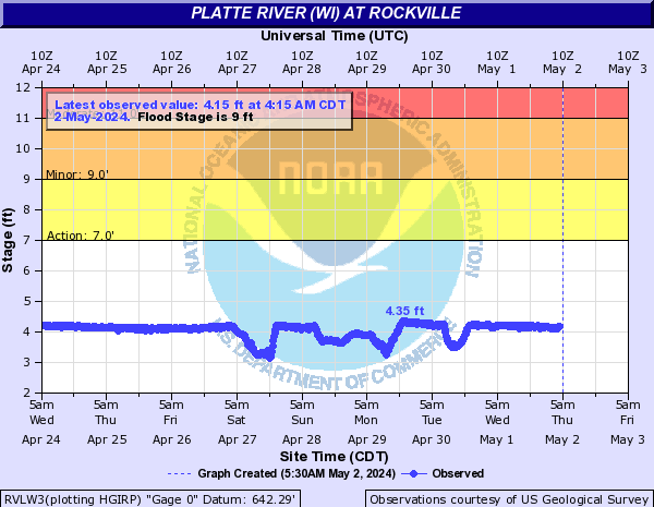
Platte River (WI) (Click on an image to go to hydrograph webpage)
RVLW3:
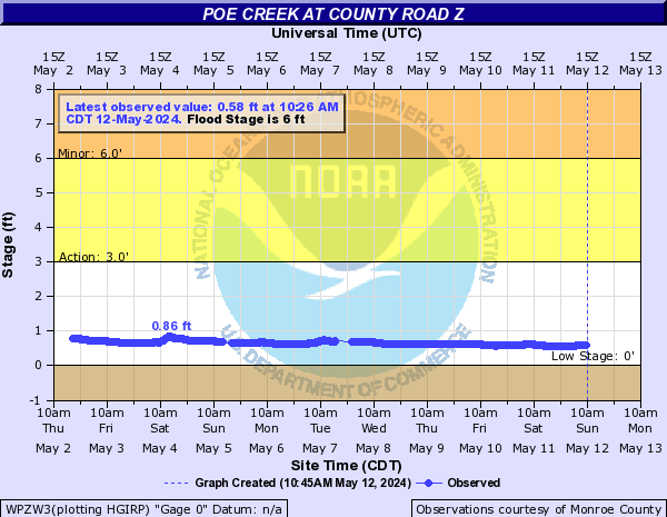
Poe Creek (Click on an image to go to hydrograph webpage)
WPZW3:
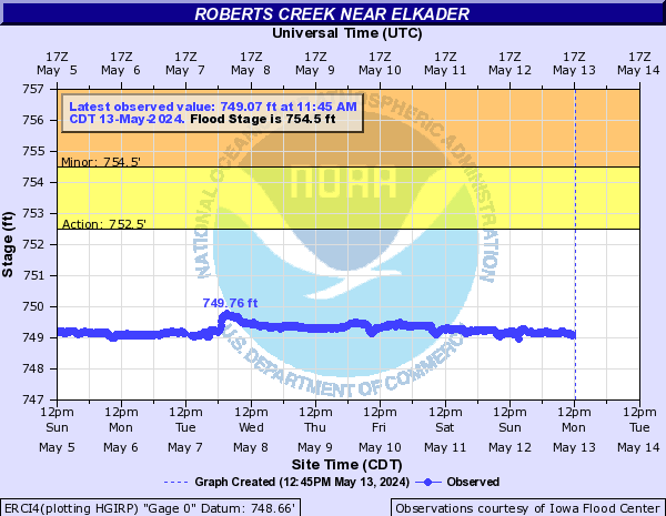
Roberts Creek (Click on an image to go to hydrograph webpage)
ERCI4:
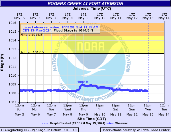
Rogers Creek (Click on an image to go to hydrograph webpage)
FTAI4:
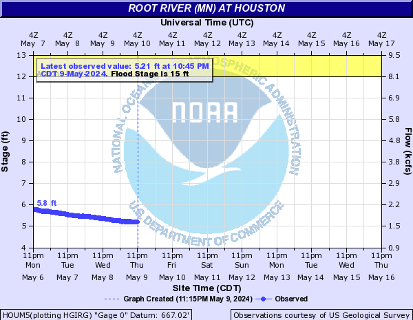
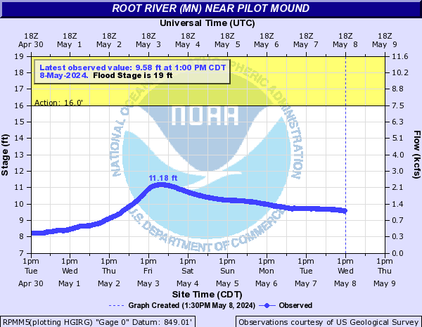
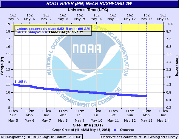
Root River (MN) (Click on an image to go to hydrograph webpage)
HOUM5:
RPMM5:
RSFM5:
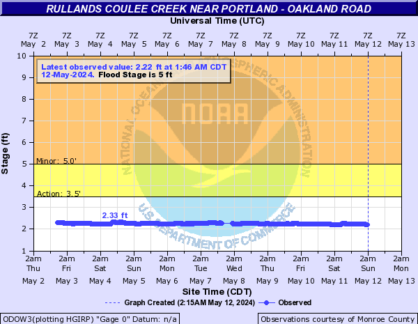
Rullands Coulee Creek (Click on an image to go to hydrograph webpage)
ODOW3:
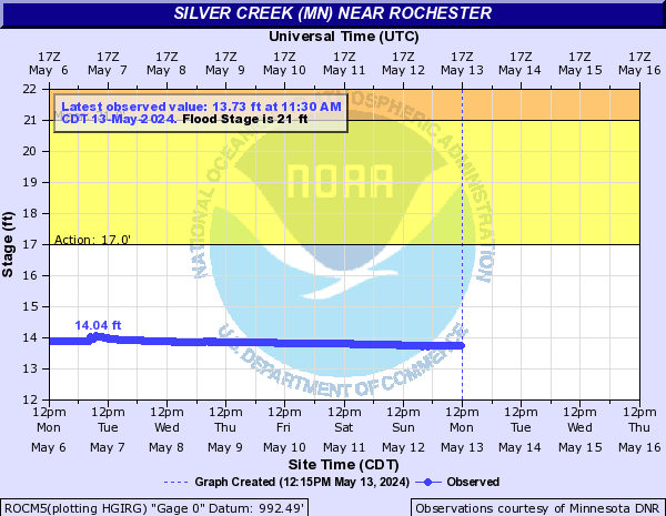
Silver Creek (MN) (Click on an image to go to hydrograph webpage)
ROCM5:
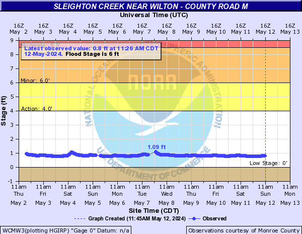
Sleighton Creek (Click on an image to go to hydrograph webpage)
WCMW3:
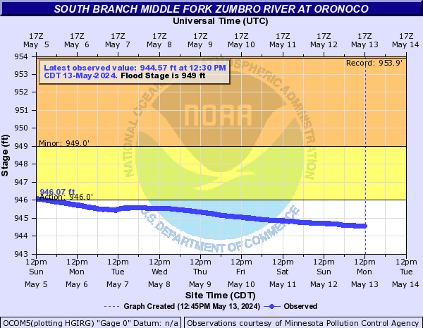
South Branch Middle Fork Zumbro River (Click on an image to go to hydrograph webpage)
OXBM5:

OCOM5:
WSJM5:
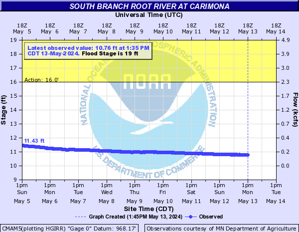
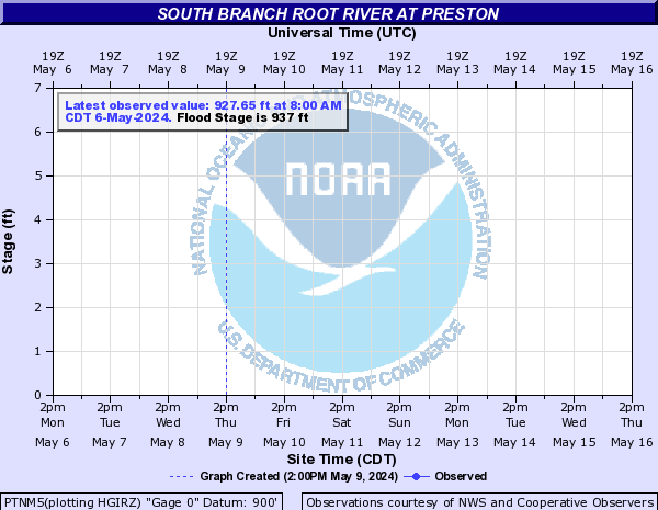
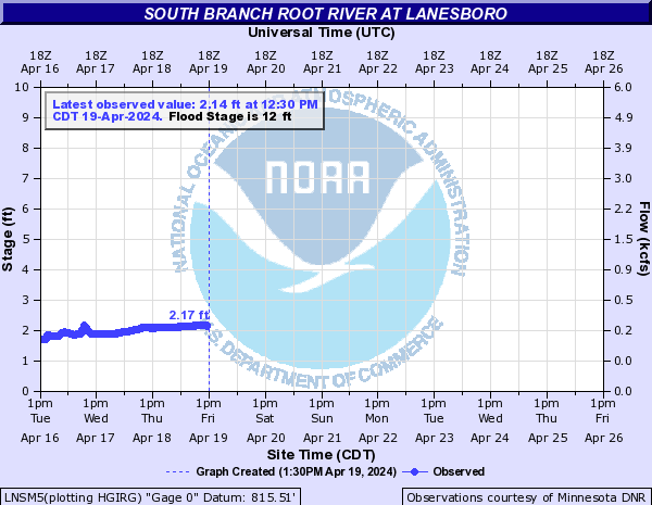
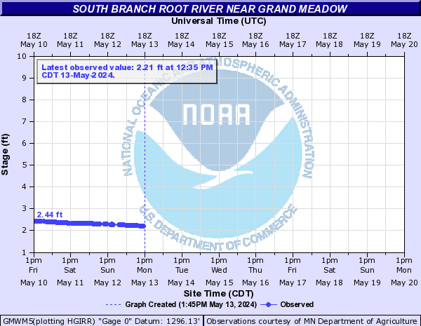
South Branch Root River (Click on an image to go to hydrograph webpage)
CMAM5:
PTNM5:
LNSM5:
GMWM5:
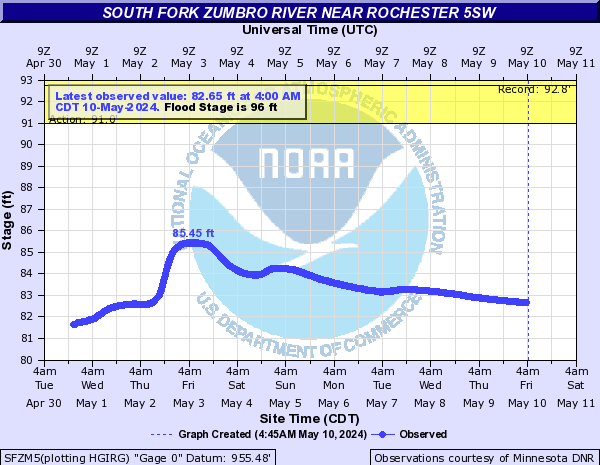
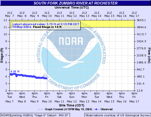
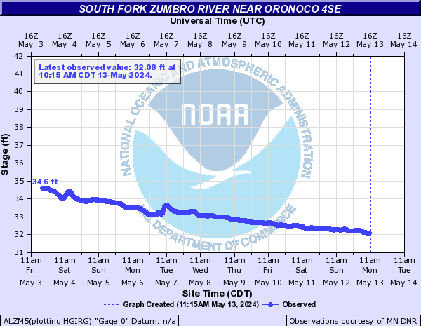
South Fork Zumbro River (Click on an image to go to hydrograph webpage)
SFZM5:
RCSM5:

RCHM5:
ALZM5:
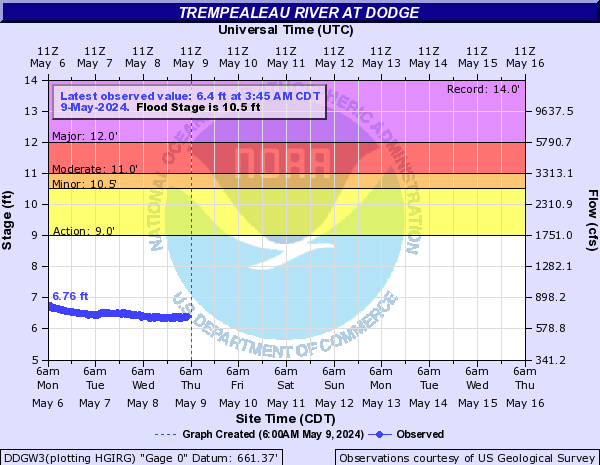
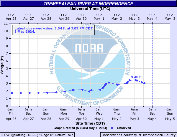
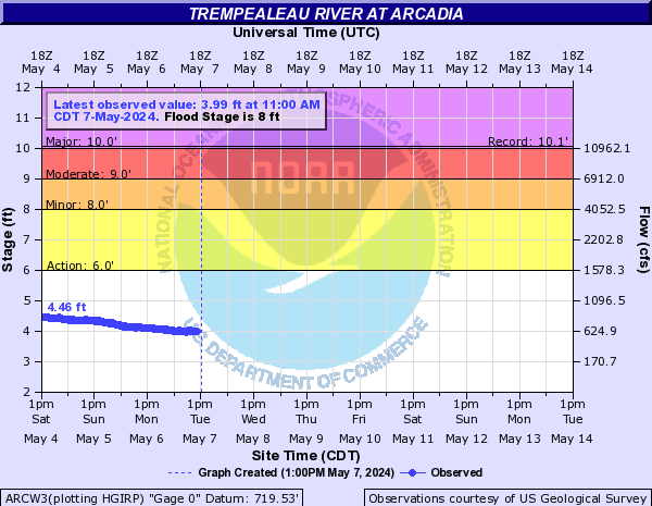
Trempealeau River (Click on an image to go to hydrograph webpage)
DDGW3:
IDPW3:
WHIW3:
TBLW3:
ARCW3:
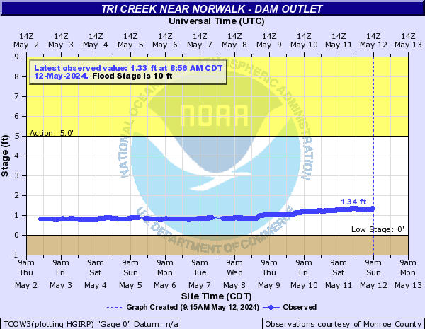
Tri Creek (Click on an image to go to hydrograph webpage)
TCOW3:
TCIW3:

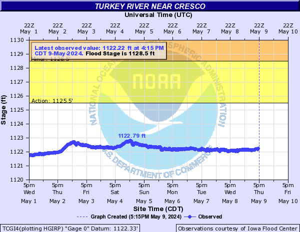
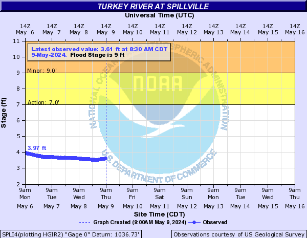
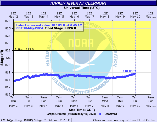
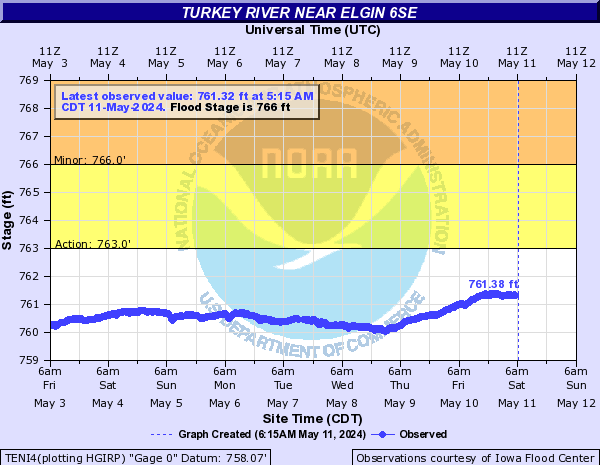
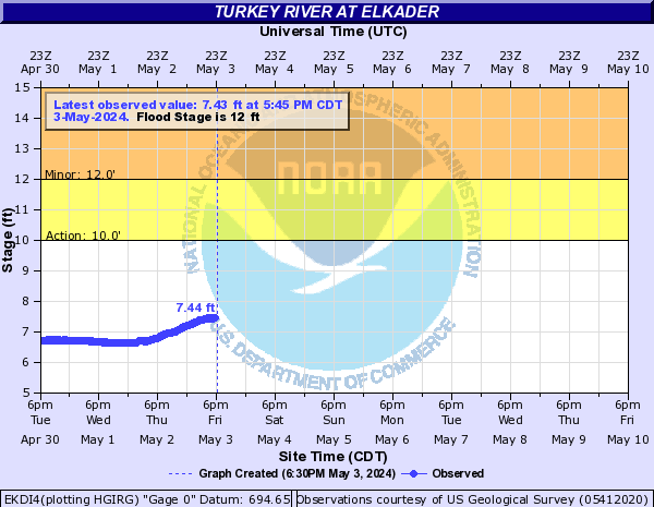
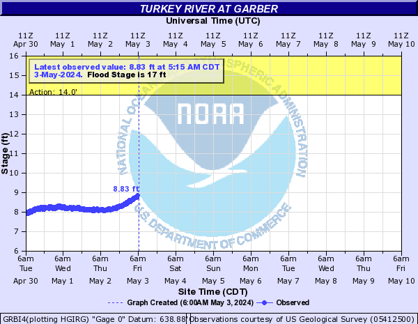
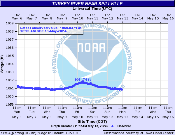
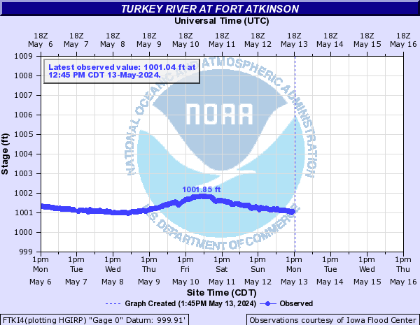
Turkey River (Click on an image to go to hydrograph webpage)
TCGI4:
SPLI4:
EDRI4:

CMTI4:
TENI4:
EKDI4:
GRBI4:
SPVI4:
FTKI4:
OTUI4:

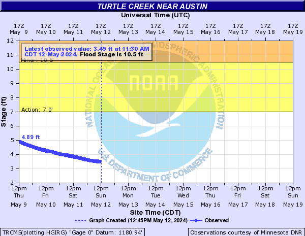
Turtle Creek (Click on an image to go to hydrograph webpage)
TRCM5:
Upper Brush Creek (Click on an image to go to hydrograph webpage)
UBCW3:

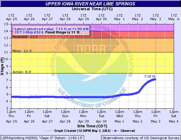
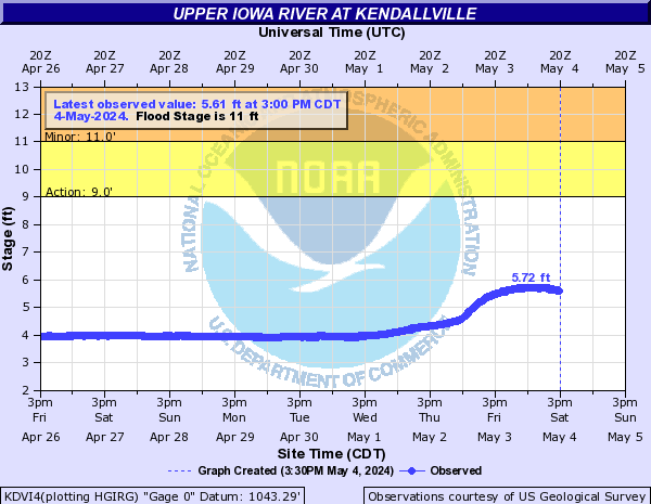
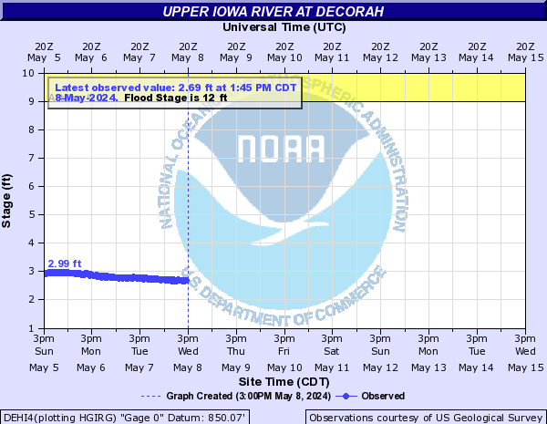
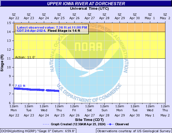
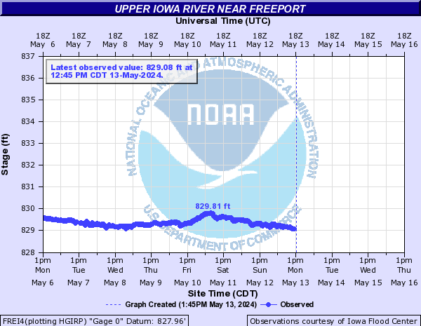
Upper Iowa River (Click on an image to go to hydrograph webpage)
LSPI4:
KDVI4:
BLFI4:

UIDI4:

DEHI4:
DCHI4:
FREI4:
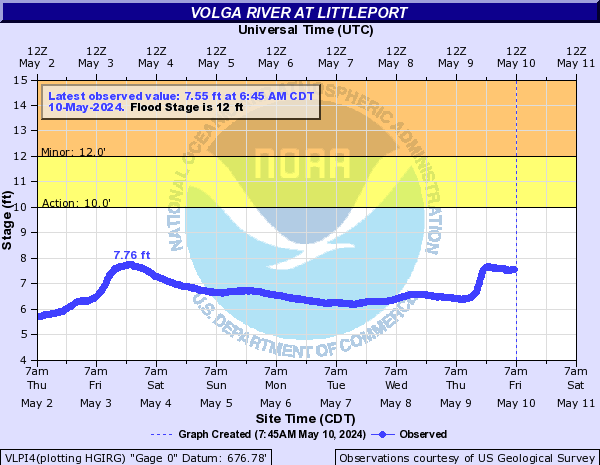
Volga River (Click on an image to go to hydrograph webpage)
WADI4:
VGAI4:

VLPI4:
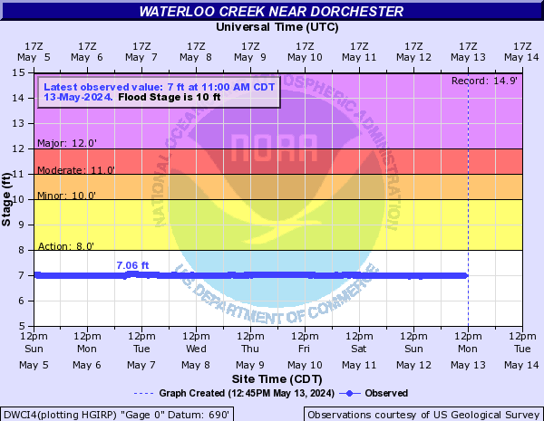
Waterloo Creek (Click on an image to go to hydrograph webpage)
DWCI4:
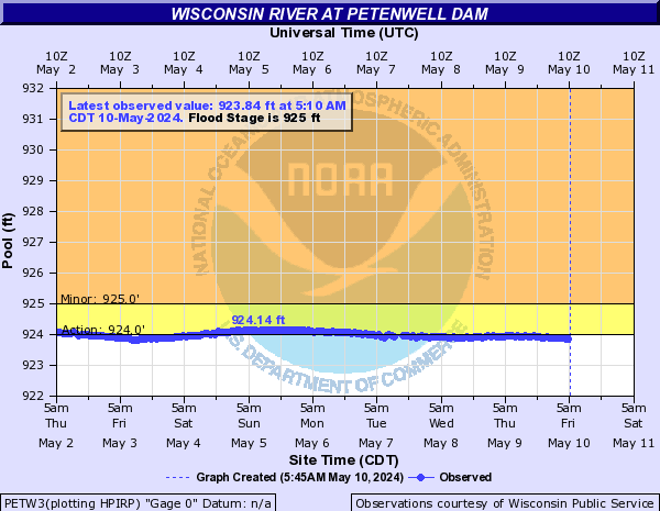
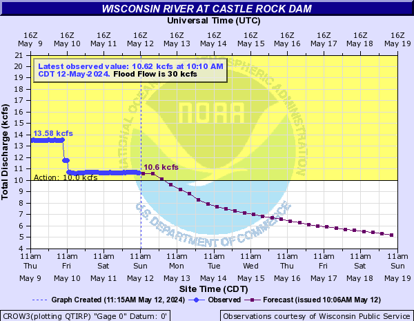
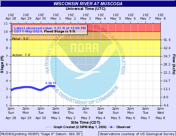
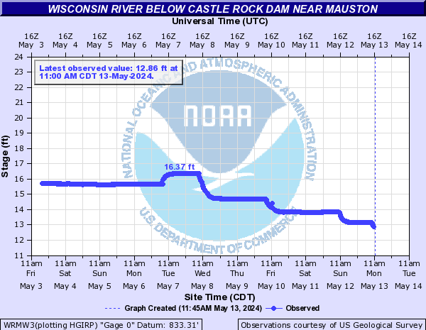
Wisconsin River (Click on an image to go to hydrograph webpage)
PETW3:
CROW3:
MUSW3:
WRMW3:
Wonder Creek (Click on an image to go to hydrograph webpage)
WONI4:

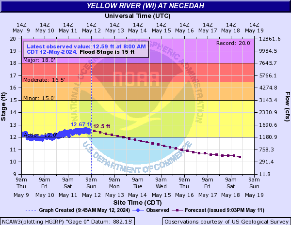
Yellow River (WI) (Click on an image to go to hydrograph webpage)
NCAW3:
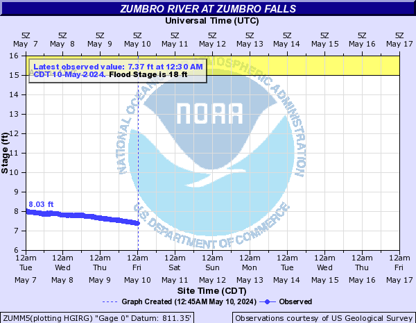
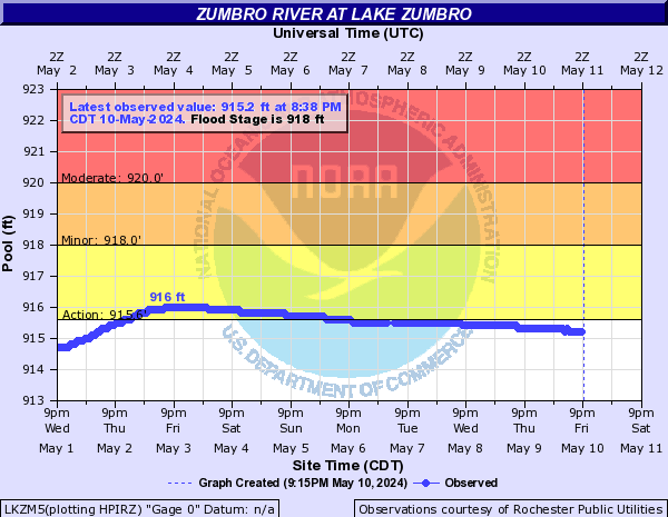
Zumbro River (Click on an image to go to hydrograph webpage)
LZIM5:
LKZM5:
ZUMM5: