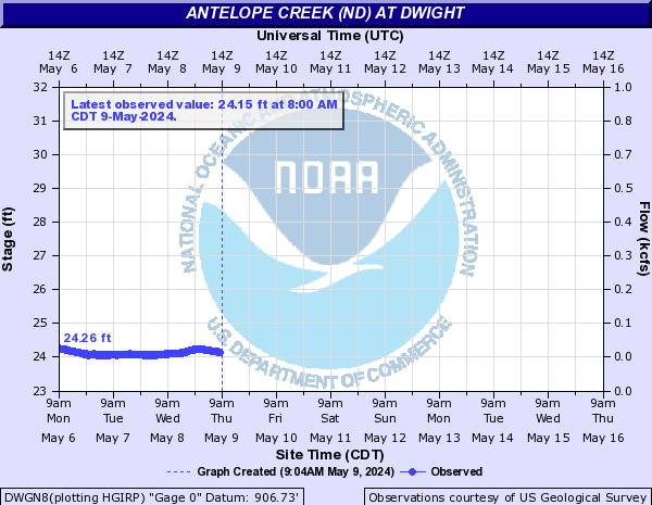
Antelope Creek (ND) (Click on an image to go to hydrograph webpage)
DWGN8:
Badger Creek (MB) (Click on an image to go to hydrograph webpage)
BCCQ3:

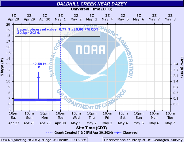
Baldhill Creek (Click on an image to go to hydrograph webpage)
DBCN8:
Battle River (Click on an image to go to hydrograph webpage)
SAUM5:
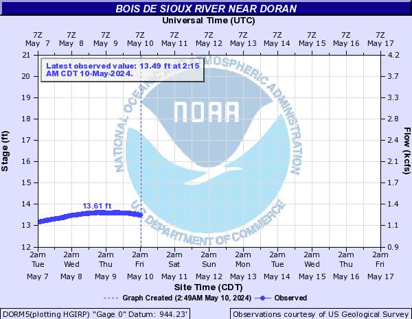
Bois de Sioux River (Click on an image to go to hydrograph webpage)
DORM5:
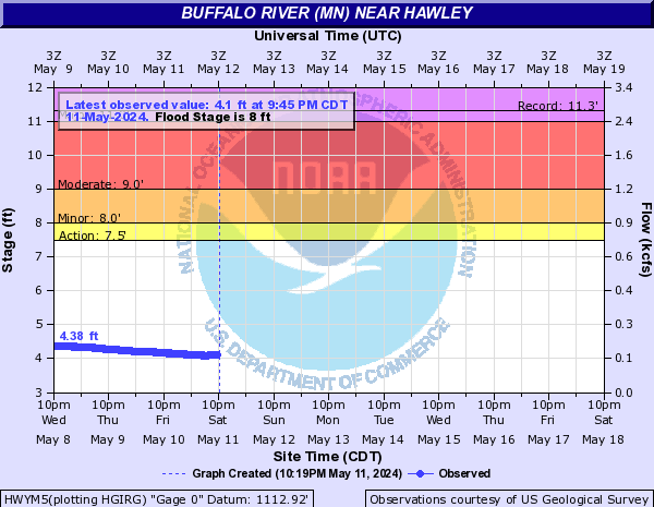
Buffalo River (MN) (Click on an image to go to hydrograph webpage)
BRGM5:

DILM5:

HWYM5:
BGLM5:

Clearwater River (MN) (Click on an image to go to hydrograph webpage)
PLUM5:

RDLM5:

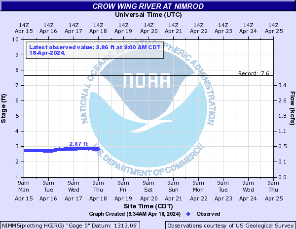
Crow Wing River (Click on an image to go to hydrograph webpage)
NIMM5:
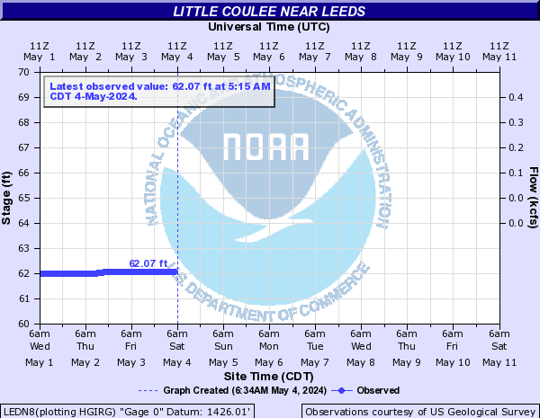
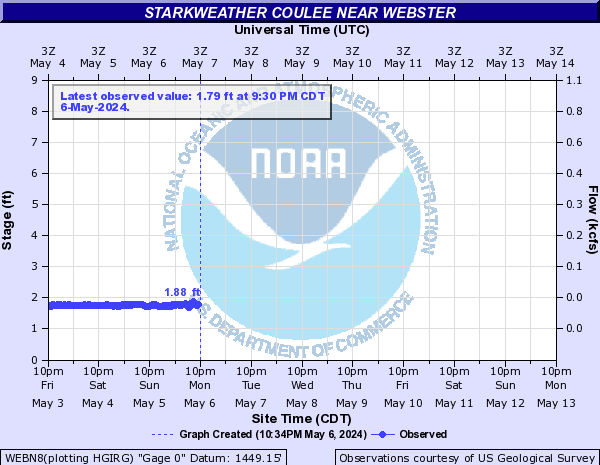
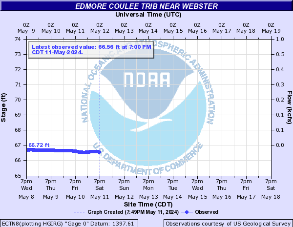
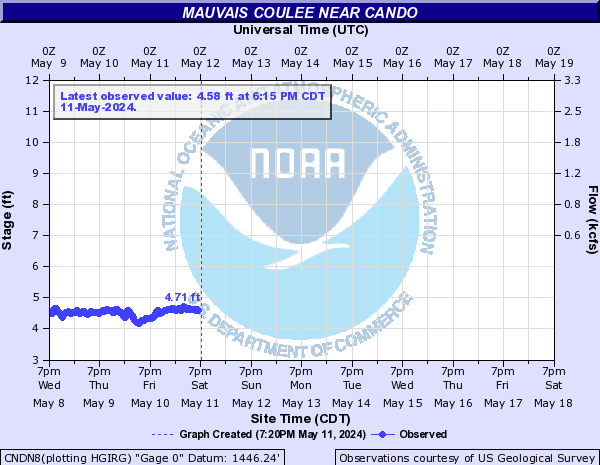
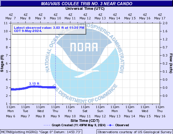
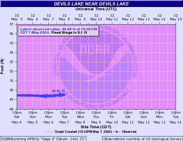
Devils Lake (Click on an image to go to hydrograph webpage)
LEDN8:
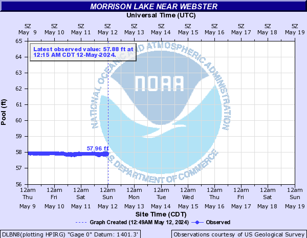
WEBN8:
ECTN8:
CNDN8:
MCTN8:
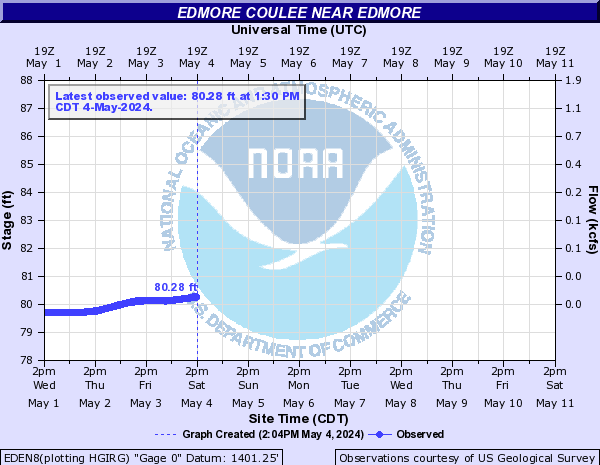
EDEN8:
DLBN8:
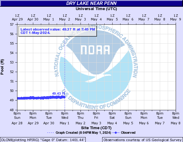
DLCN8:
IRVN8:

DCBN8:
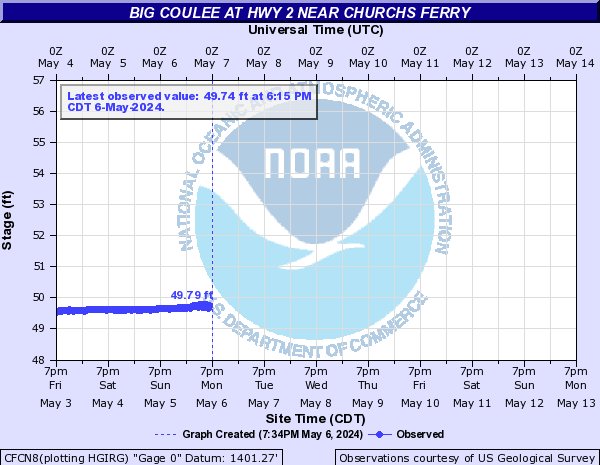
CFCN8:
Eastern Stump Lake (Click on an image to go to hydrograph webpage)
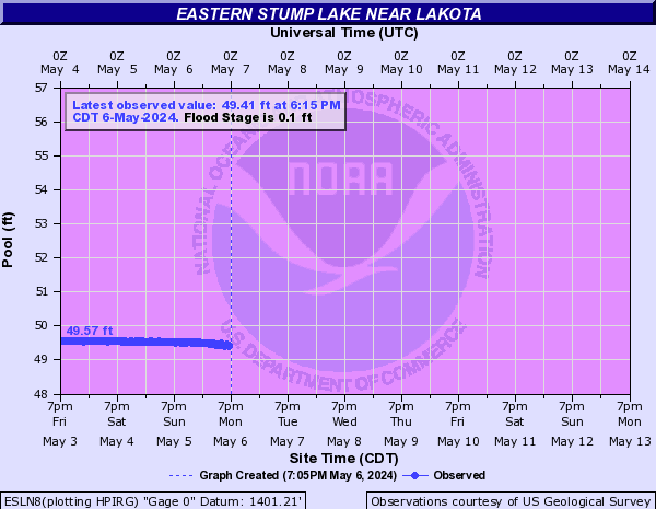
ESLN8:
Elm River (Click on an image to go to hydrograph webpage)
ELMN8:

NBEN8:

Forest River (Click on an image to go to hydrograph webpage)
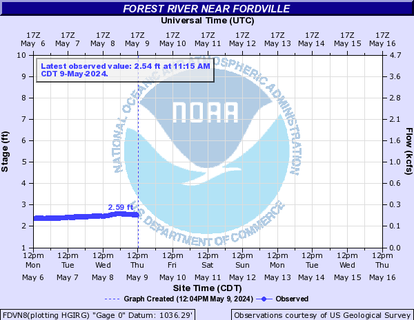
FDVN8:
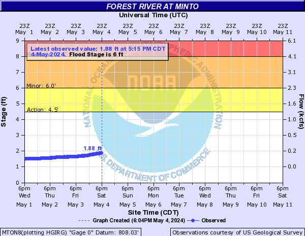
MTON8:
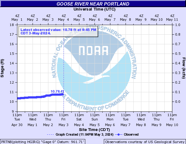
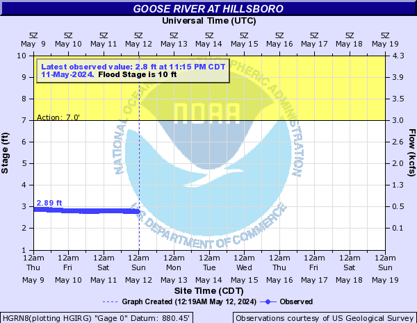
Goose River (Click on an image to go to hydrograph webpage)
PRTN8:
HGRN8:
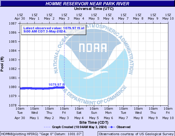
Homme Reservoir (Click on an image to go to hydrograph webpage)
HOMN8:
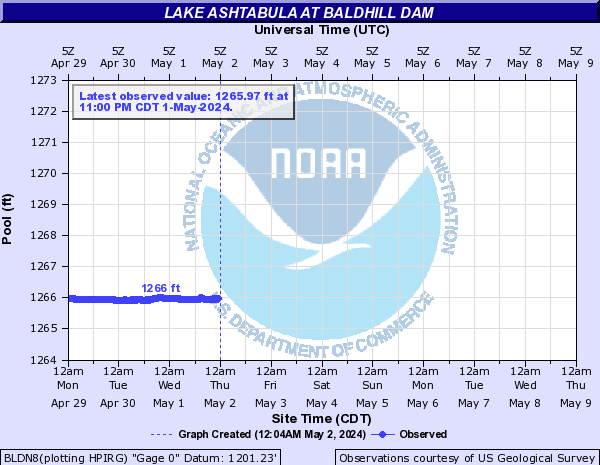
Lake Ashtabula (Click on an image to go to hydrograph webpage)
BLDN8:
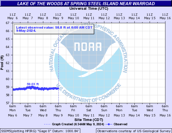
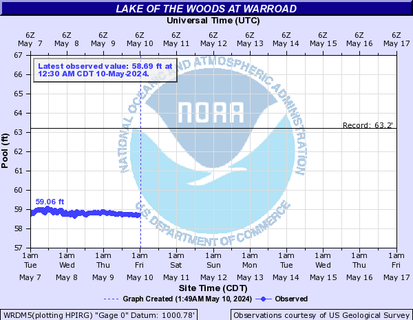
Lake of the Woods (Click on an image to go to hydrograph webpage)
SSIM5:
WRDM5:
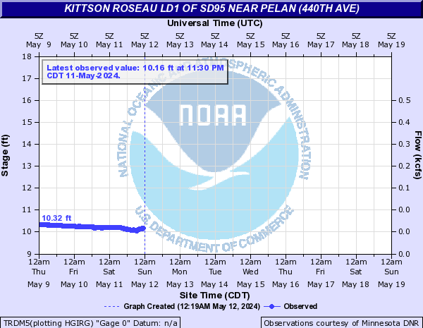
Lateral 1 (Click on an image to go to hydrograph webpage)
TRDM5:
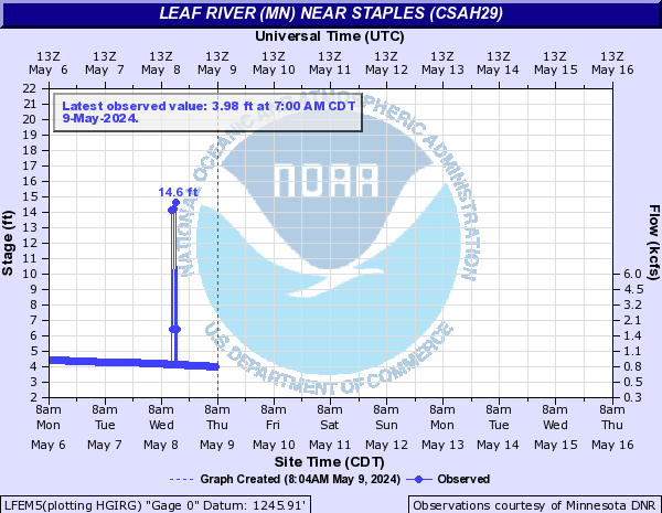
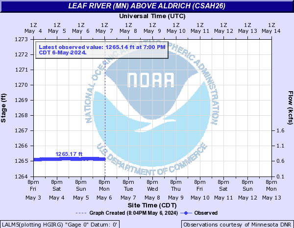
Leaf River (MN) (Click on an image to go to hydrograph webpage)
LFEM5:
LALM5:
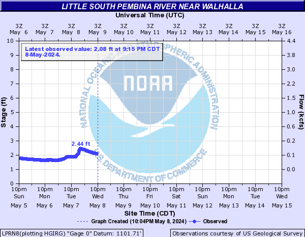
Little South Pembina River (Click on an image to go to hydrograph webpage)
LPRN8:
Long River (MB) (Click on an image to go to hydrograph webpage)
LRHQ3:

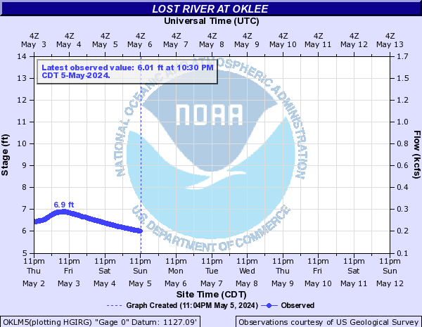
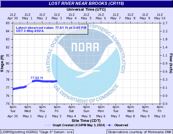
Lost River (Click on an image to go to hydrograph webpage)
OKLM5:
LOSM5:
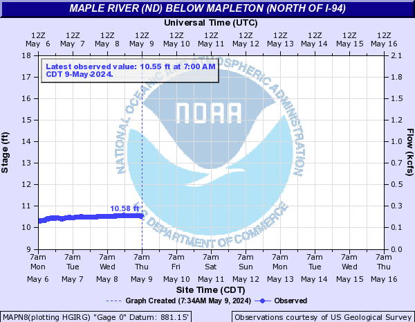
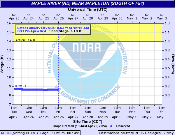
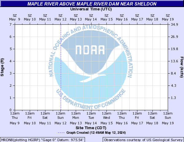
Maple River (ND) (Click on an image to go to hydrograph webpage)
BOBN8:

ENDN8:

MAPN8:
MPLN8:
MRDN8:
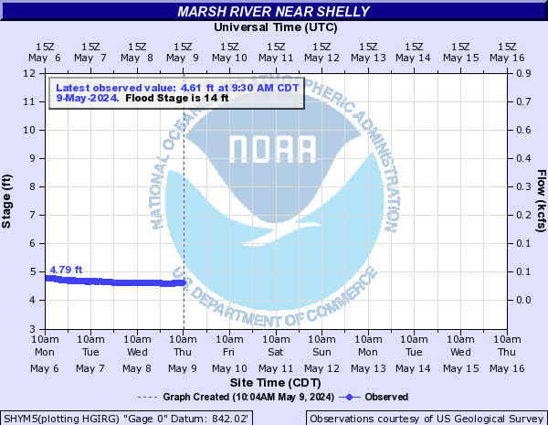
Marsh River (Click on an image to go to hydrograph webpage)
SHYM5:
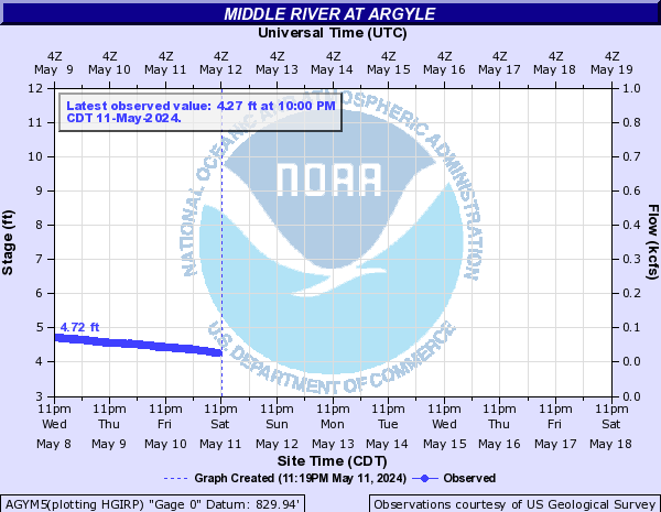
Middle River (Click on an image to go to hydrograph webpage)
AGYM5:
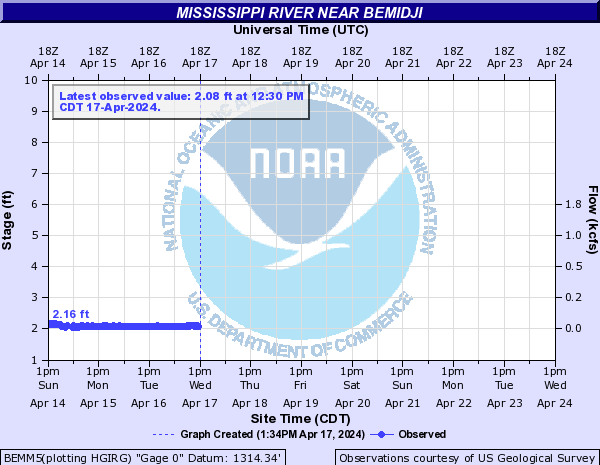
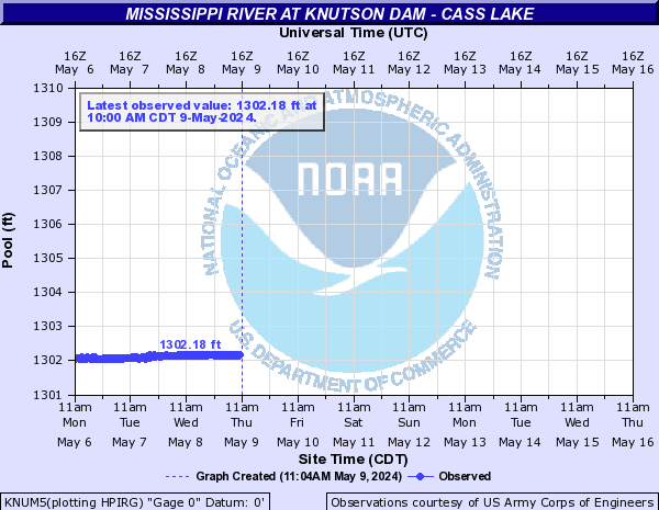
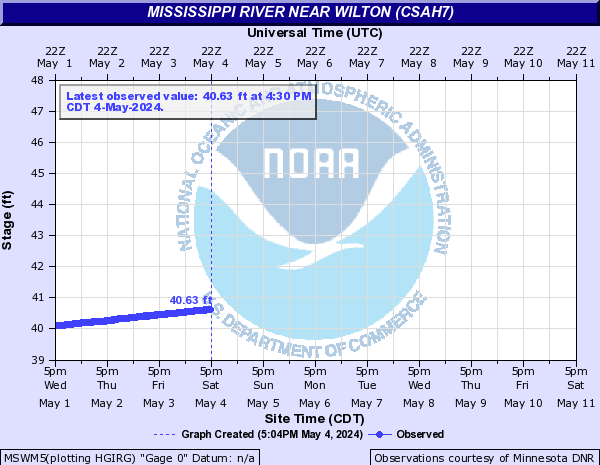
Mississippi River (Click on an image to go to hydrograph webpage)
BEMM5:
KNUM5:
MSWM5:
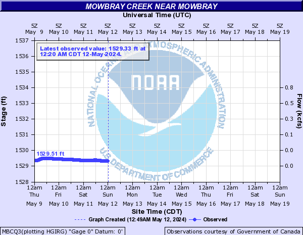
Mowbray Creek (Click on an image to go to hydrograph webpage)
MBCQ3:
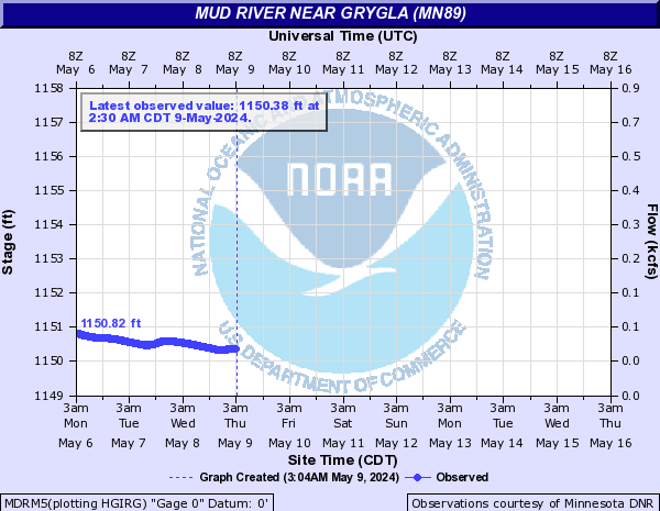
Mud River (Click on an image to go to hydrograph webpage)
MDRM5:
Mustinka River (Click on an image to go to hydrograph webpage)
NCMM5:
North Branch Two Rivers River (Click on an image to go to hydrograph webpage)
NCTM5:
NOTM5:

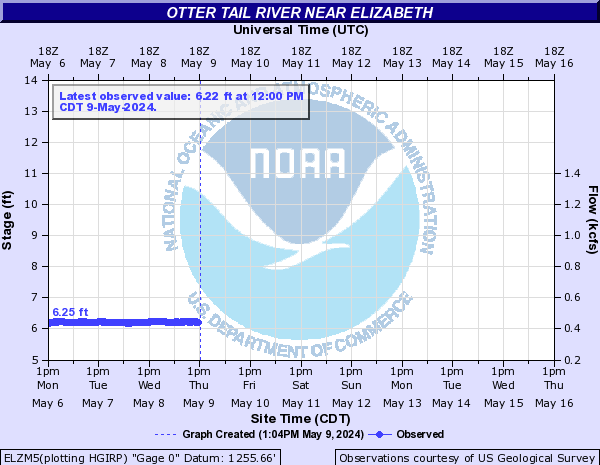
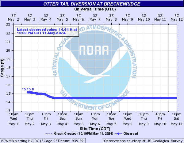
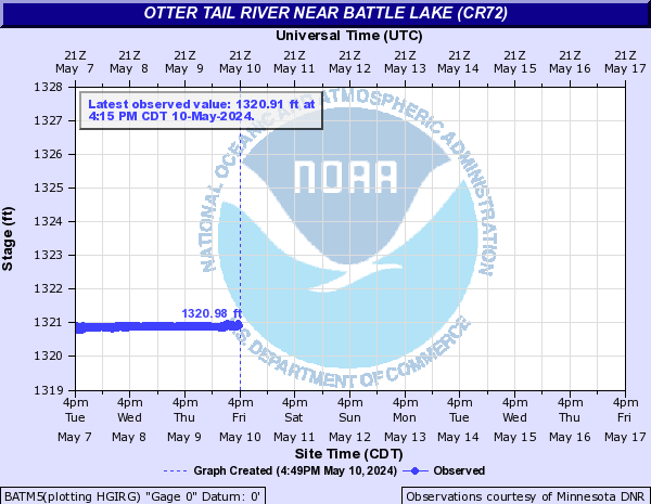
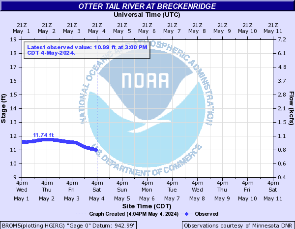
Otter Tail River (Click on an image to go to hydrograph webpage)
ELZM5:
ORWM5:

BTWM5:
BATM5:
BROM5:
RCTM5:

OTRM5:
Park River (Click on an image to go to hydrograph webpage)
GRNN8:
GFBN8:
Pelican River (Click on an image to go to hydrograph webpage)
FFPM5:
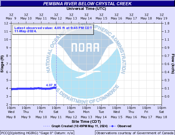
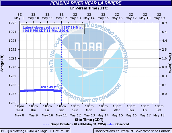
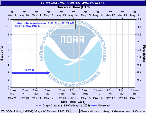
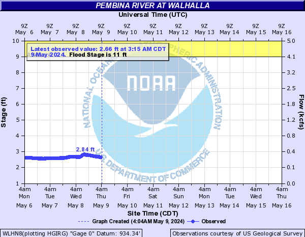
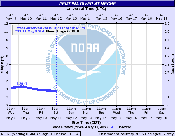
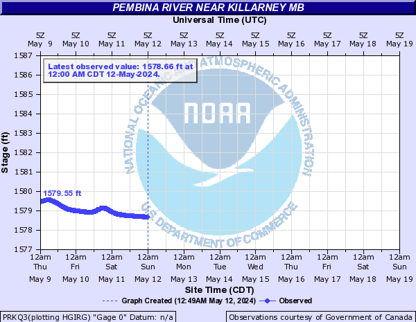
Pembina River (Click on an image to go to hydrograph webpage)
PCCQ3:
PLRQ3:
WNDQ3:
WLHN8:
NCEN8:
PRKQ3:
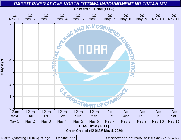
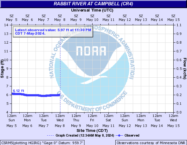
Rabbit River (Click on an image to go to hydrograph webpage)
NOPM5:
CSRM5:
JAHM5:

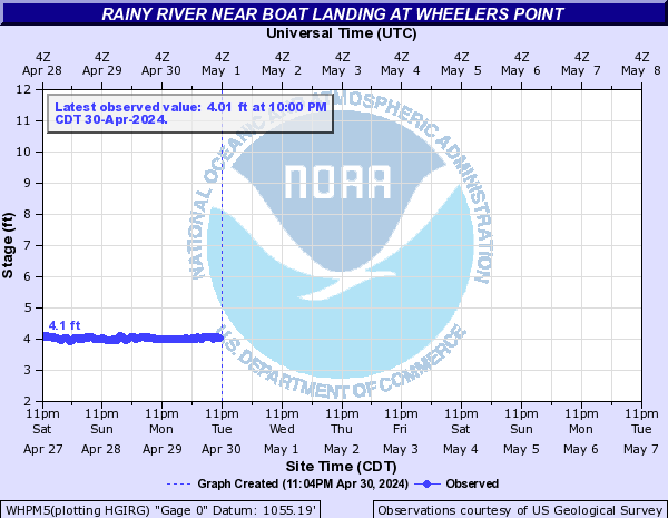
Rainy River (Click on an image to go to hydrograph webpage)
WHPM5:
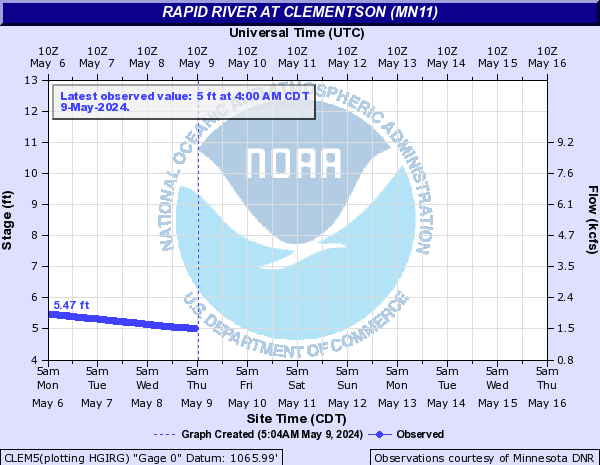
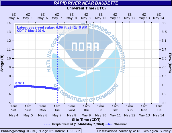
Rapid River (Click on an image to go to hydrograph webpage)
CLEM5:
BRRM5:
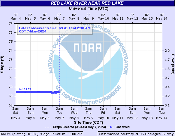
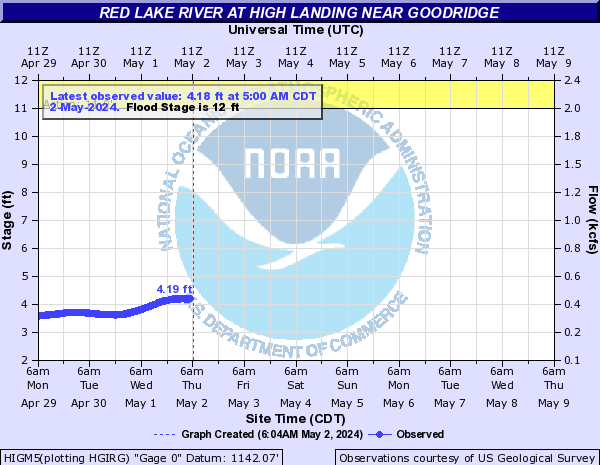
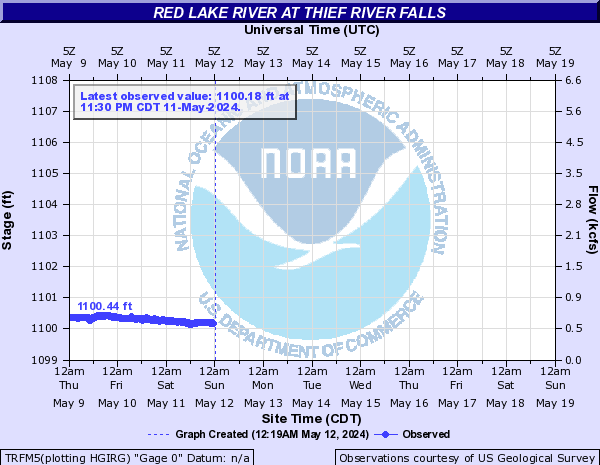
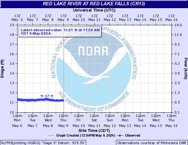
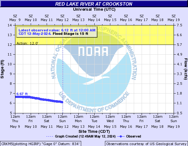
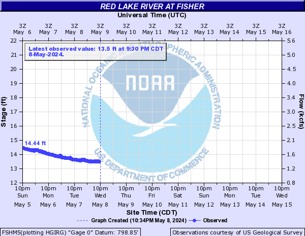
Red Lake River (Click on an image to go to hydrograph webpage)
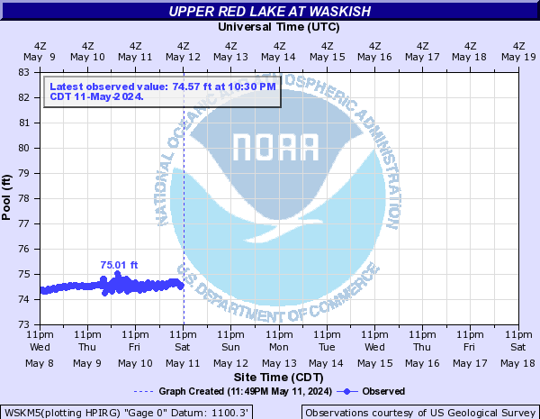
WSKM5:
RRDM5:
HIGM5:
TRFM5:
RLFM5:
CRKM5:
FSHM5:
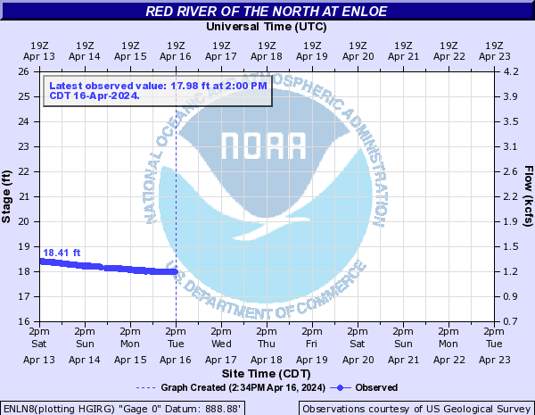
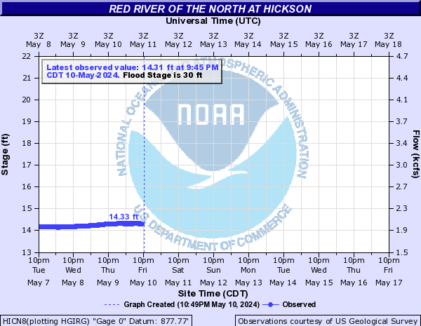
Red River of the North (Click on an image to go to hydrograph webpage)
WHNN8:

ENLN8:
HICN8:
FGON8:

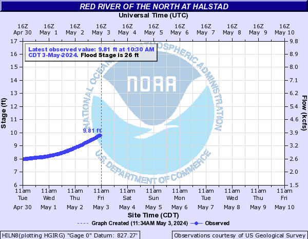
HILN8:
TPNN8:

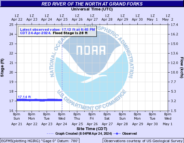
EGFM5:
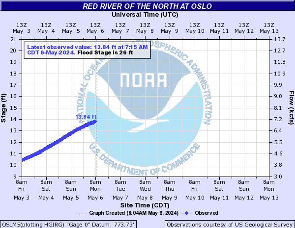
OSLM5:
DRTN8:

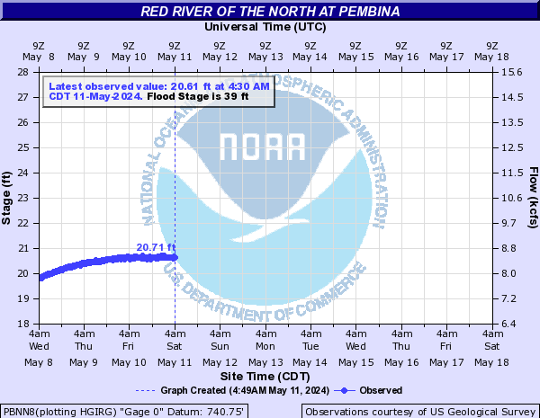
PBNN8:
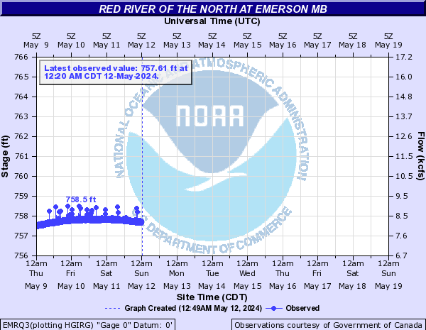
EMRQ3:
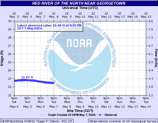
GEGM5:
Redeye River (Click on an image to go to hydrograph webpage)
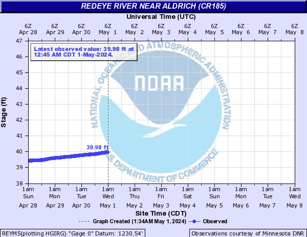
REYM5:
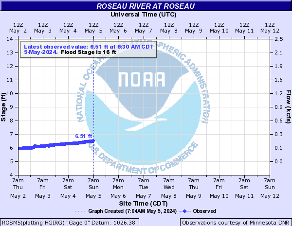
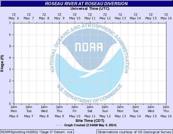
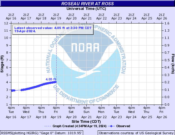
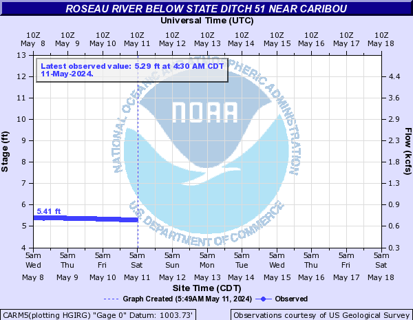
Roseau River (Click on an image to go to hydrograph webpage)
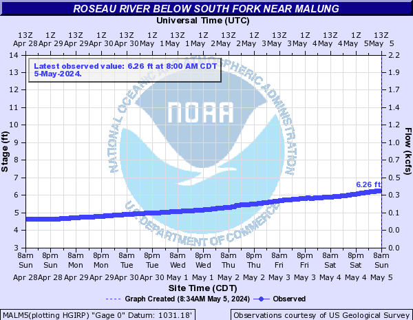
MALM5:
ROSM5:
RDVM5:
RSSM5:
CARM5:
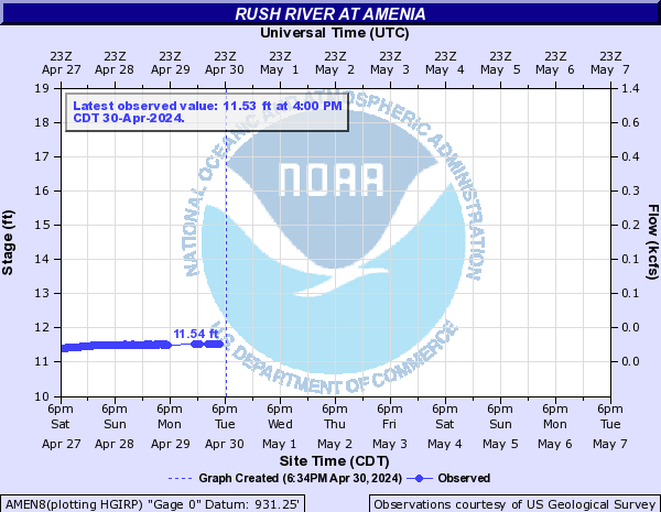
Rush River (Click on an image to go to hydrograph webpage)
AMEN8:
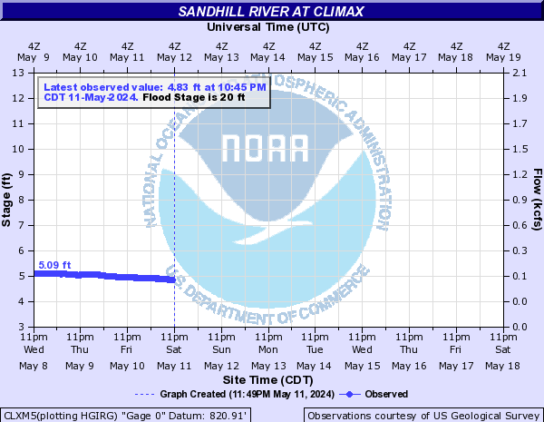
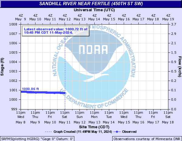
Sandhill River (Click on an image to go to hydrograph webpage)
CLXM5:
SRFM5:
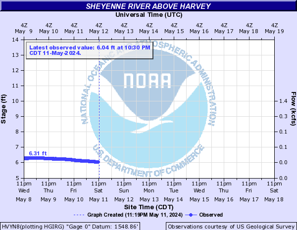
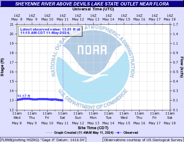
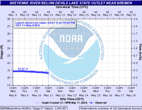
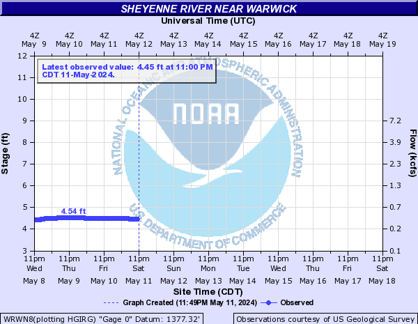
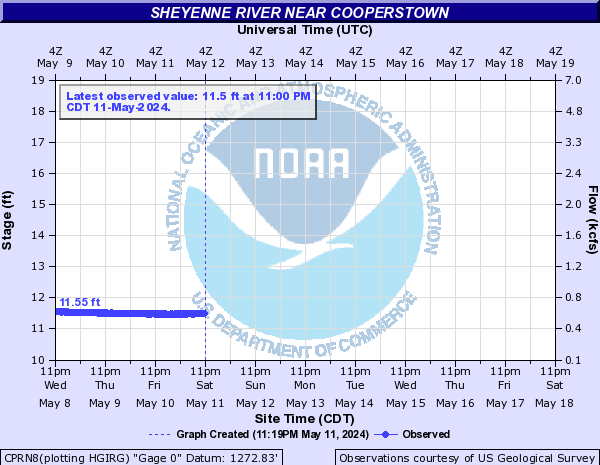
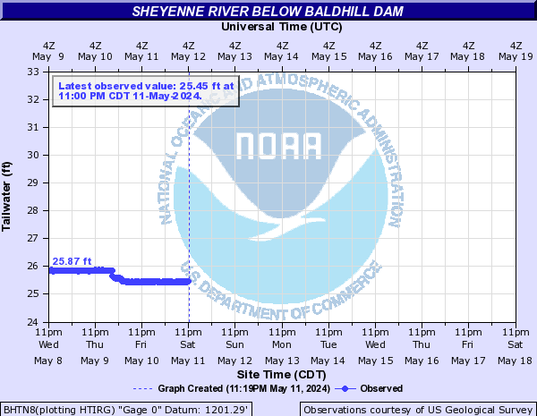
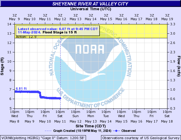
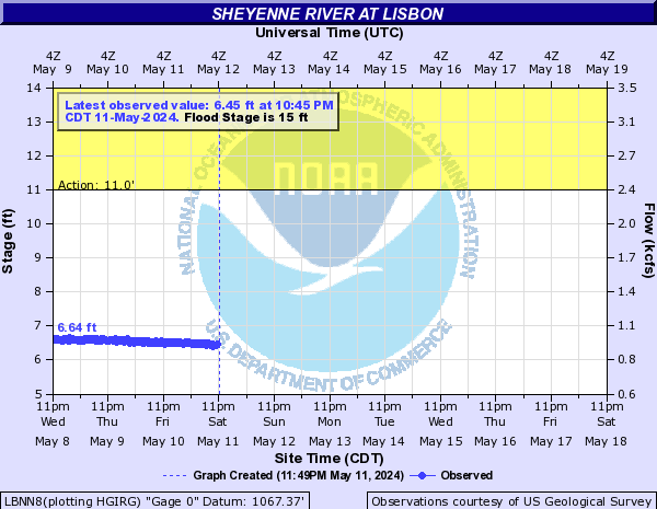
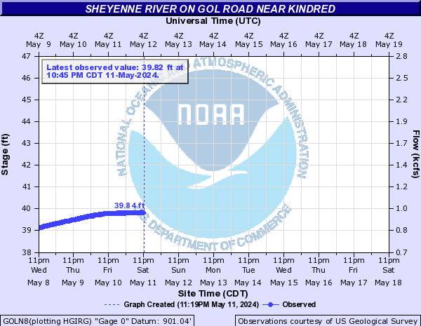
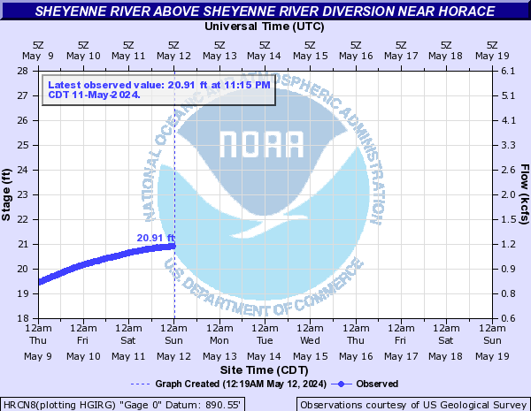
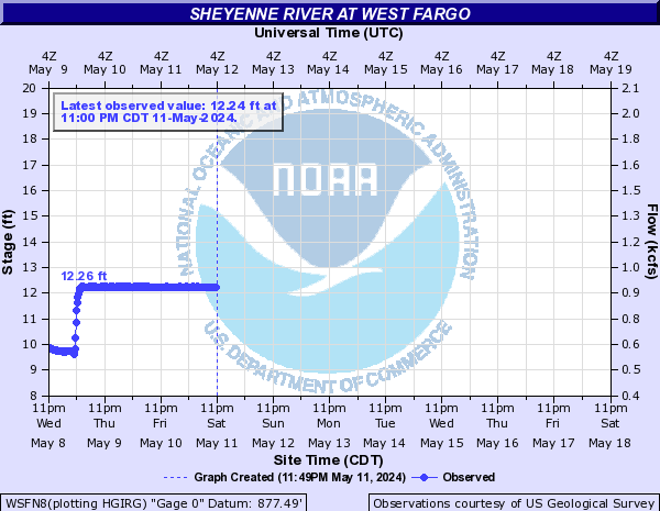
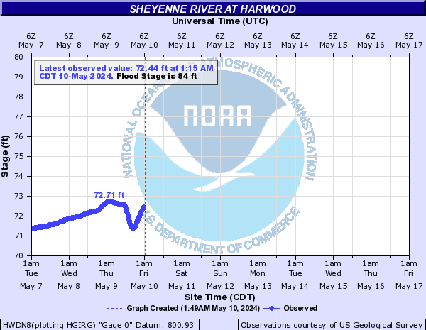
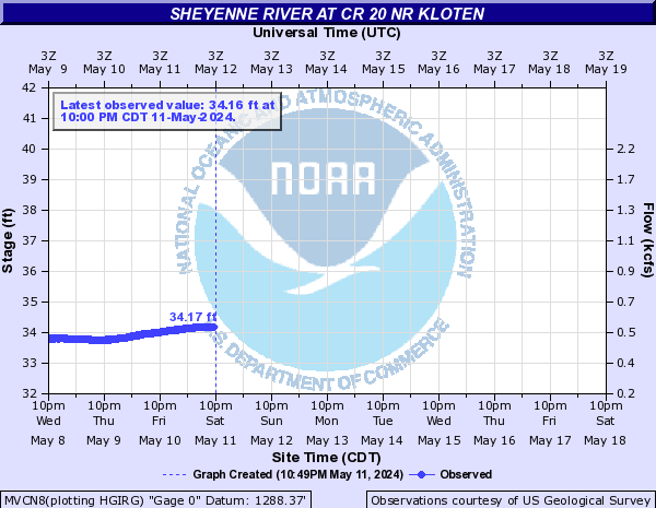
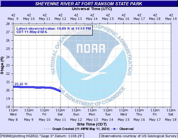
Sheyenne River (Click on an image to go to hydrograph webpage)
HVYN8:
MADN8:
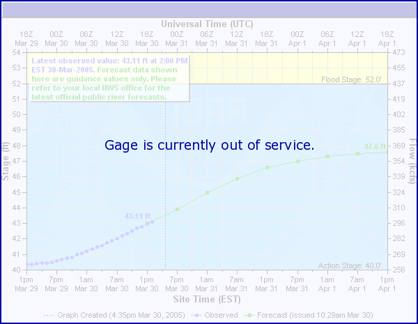
FLRN8:
BRMN8:
WRWN8:
CPRN8:
BHTN8:
VCRN8:
LBNN8:
GOLN8:
KNDN8:

HRCN8:
WFON8:
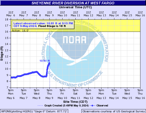
WSFN8:
HWDN8:
MVCN8:
FRSN8:
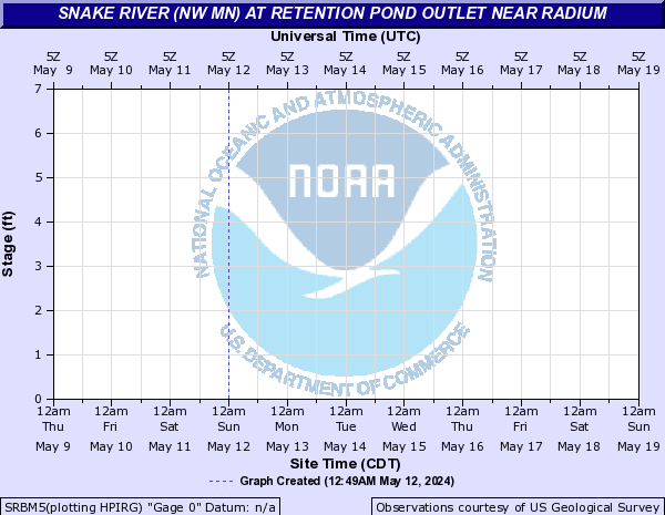
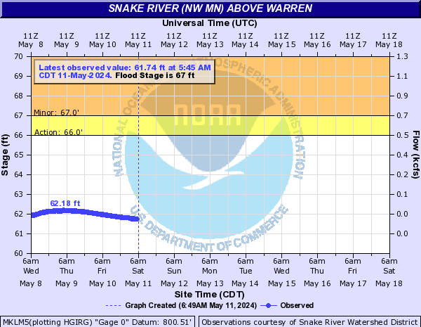
Snake River (NW MN) (Click on an image to go to hydrograph webpage)
SRBM5:
ALVM5:

MKLM5:
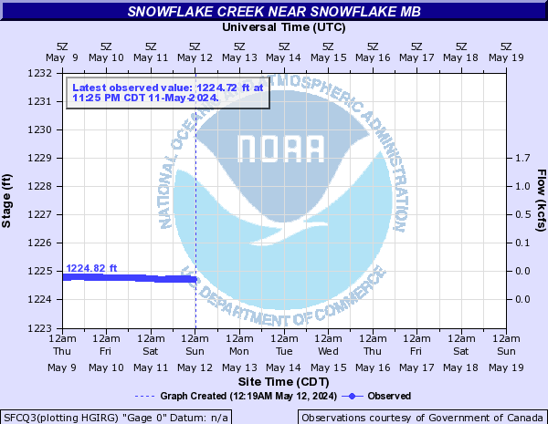
Snowflake Creek (Click on an image to go to hydrograph webpage)
SFCQ3:
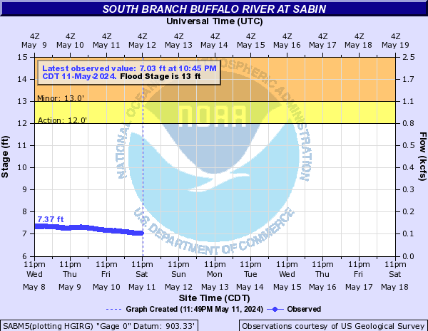
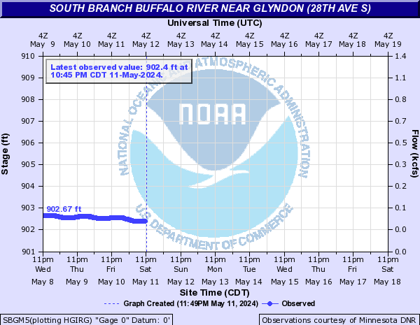
South Branch Buffalo River (Click on an image to go to hydrograph webpage)
SABM5:
SBGM5:
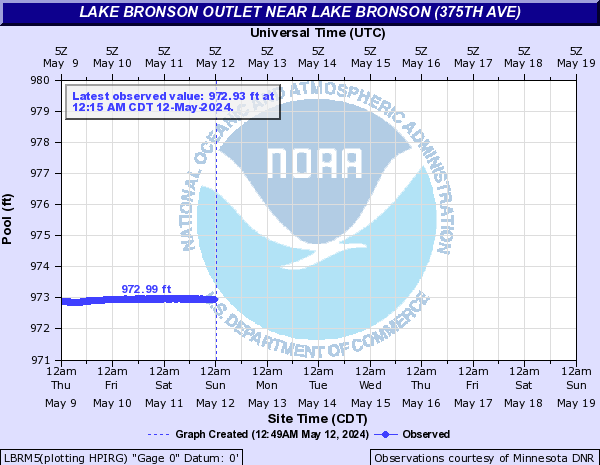
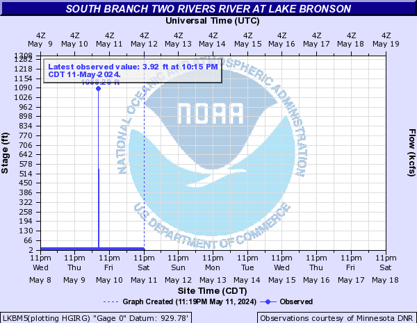
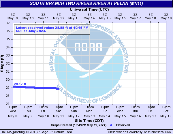
South Branch Two Rivers River (Click on an image to go to hydrograph webpage)
LBRM5:
LKBM5:
TRPM5:
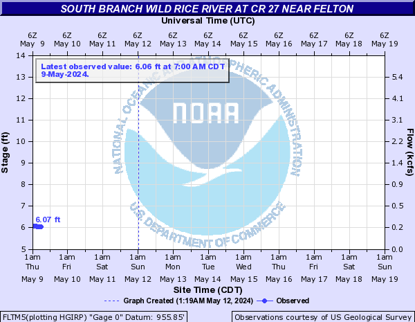
South Branch Wild Rice River (Click on an image to go to hydrograph webpage)
FLTM5:
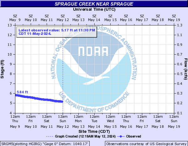
Sprague Creek (Click on an image to go to hydrograph webpage)
SRGM5:
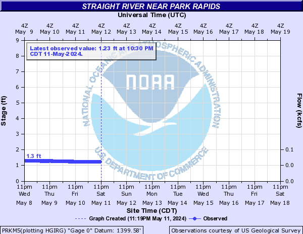
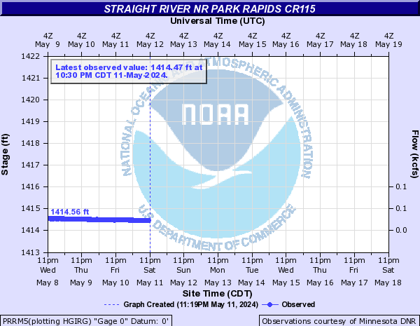
Straight River (Click on an image to go to hydrograph webpage)
PRKM5:
PRRM5:
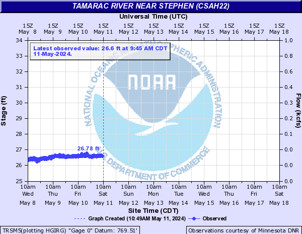
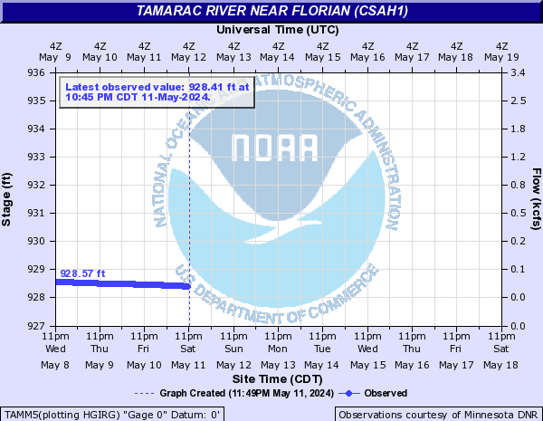
Tamarac River (Click on an image to go to hydrograph webpage)
TRSM5:
TAMM5:
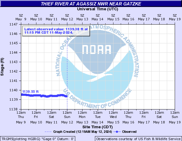
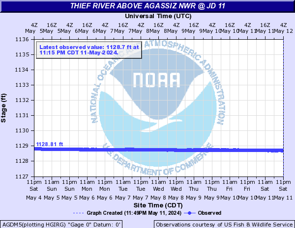
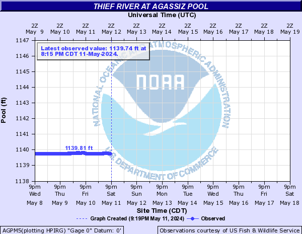
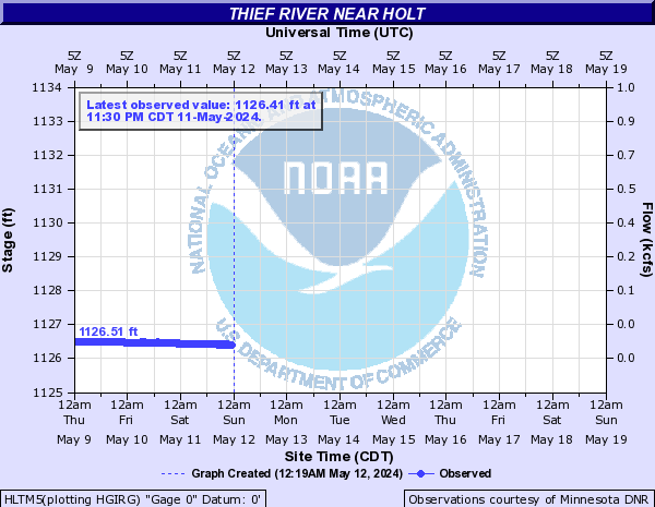
Thief River (Click on an image to go to hydrograph webpage)
TRGM5:
AGDM5:
AGPM5:
TRRM5:

HLTM5:
Toad River (Click on an image to go to hydrograph webpage)
PHMM5:

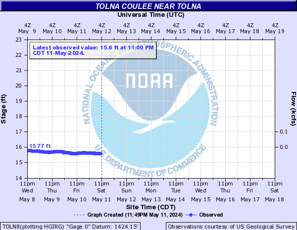
Tolna Coulee (Click on an image to go to hydrograph webpage)
TOLN8:
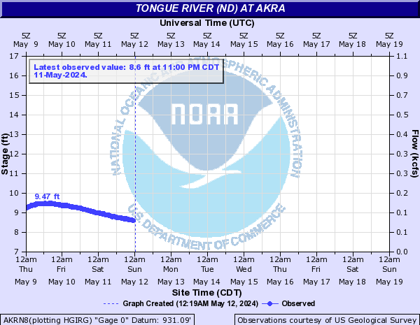
Tongue River (ND) (Click on an image to go to hydrograph webpage)
AKRN8:
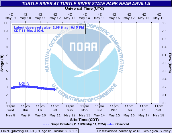
Turtle River (Click on an image to go to hydrograph webpage)
LTRN8:
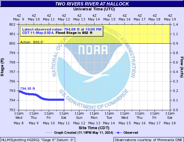
Two Rivers River (Click on an image to go to hydrograph webpage)
HLLM5:
Warroad River (Click on an image to go to hydrograph webpage)
EWRM5:
WBWM5:

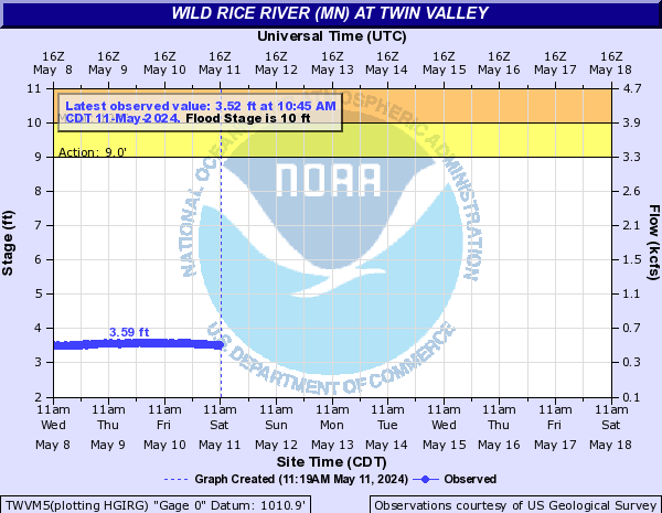
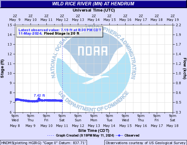
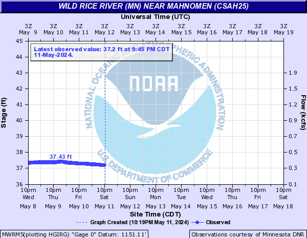
Wild Rice River (MN) (Click on an image to go to hydrograph webpage)
TWVM5:
ADSM5:

HNDM5:
MWRM5:
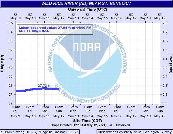
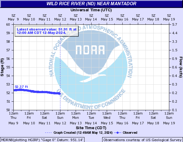
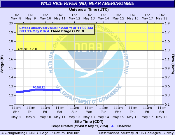
Wild Rice River (ND) (Click on an image to go to hydrograph webpage)
FWRN8:

MDRN8:
ABRN8:
STBN8: