Pedernales River at Johnson City
Future / Actual / Minor
OWP 2.0 WWA Modal Title
01/11/2021, 10:04 PM UTC through 01/11/2021, 10:04 PM UTC
Sender
Sent
- Downstream gauge unavailableWarning: no valid ratings curve available. Transformations to and from FEET/CFS/KCFS will not happen.
Traces and Thresholds Click to turn on/off display
Observed (OBS) 04/05/2025 2:00 AM CDTRecord: 42.5 ftCATEGORY STAGE 
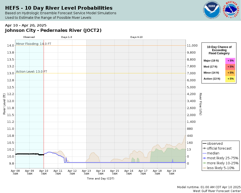
Major Flooding 19 ft Moderate Flooding 17 ft Minor Flooding 14 ft Action 13 ft Reliability of the Forecast:
NOTE: Forecasts are issued as needed during times of high water, but are not routinely available.
River forecasts for this location take into account past precipitation and the precipitation amounts expected approximately 24 hours into the future from the forecast issuance time.
National Water Model Hydrograph
Official NWS streamflow forecasts are produced by NWS hydrologic forecasters for river gauge locations using hydrologic models which are calibrated to that location. This process considers additional guidance and information, including local expertise and experience, to produce the best forecast possible. The NWM output provides supplemental guidance to NWS forecasters and should not be considered an official NWS river forecast.
Flood Impacts
- 40 - Flow reaches the slab elevation of the lowest homes in the Pedernales River flood plain near Johnson City, the rodeo grounds and the south approach of Highway 281. An RV park just below Highway 281 has up to six feet of water over the lowest sites. Widespread lowland flooding can cut off and drown hundreds of livestock. Much of Pedernales Falls State Park floods.
- 37 - Several feet of turbulent water is flowing through low areas of an RV park below Highway 281 on the right bank. Many roads and bridges in the flood plain are life threatening. Fencing and roads are damaged or destroyed. Much of Pedernales Falls State Park is flooded.
- 34 - Flow is to the lowest trailer sites of an RV park just below Highway 281 near Johnson City. Hundreds of cattle can be cut off and drowned in the flood plain. Low areas of Pedernales Falls State Park downstream flood. Roads and bridges near the river are extremely dangerous. Flow is approaching the rodeo grounds. Near the USGS 1:100 year flood level.
Gauge Info
| Coordinates | 30.2917, -98.3992 |
| RFC | WGRFC |
| State | TX |
| WFO | EWX |
| County | Blanco |
| Data Provider(s) | |
| US Geological Survey | USGS--Water Resources of the United States |
| USGS | 08153500 |
Gauge Location
Recent Crests
| 1. | 18.50 ft | on 05-08-2019 |
| 2. | 15.78 ft | on 05-04-2019 |
| 3. | 17.58 ft | on 10-16-2018 |
| 4. | 16.22 ft | on 06-02-2016 |
| 5. | 19.25 ft | on 05-24-2015 |
Recent Crests
| 1. | 18.50 ft | on 05-08-2019 |
| 2. | 15.78 ft | on 05-04-2019 |
| 3. | 17.58 ft | on 10-16-2018 |
| 4. | 16.22 ft | on 06-02-2016 |
| 5. | 19.25 ft | on 05-24-2015 |
| 6. | 20.36 ft | on 05-25-2007 |
| 7. | 17.73 ft | on 11-17-2004 |
| 8. | 26.00 ft | on 07-04-2002 |
| 9. | 22.45 ft | on 11-15-2001 |
| 10. | 25.16 ft | on 06-22-1997 |
| 11. | 21.38 ft | on 05-30-1995 |
| 12. | 21.87 ft | on 02-04-1992 |
| 13. | 21.86 ft | on 12-21-1991 |
| 14. | 17.98 ft | on 07-17-1987 |
| 15. | 24.90 ft | on 08-03-1978 |
| 16. | 22.60 ft | on 04-15-1977 |
| 17. | 21.95 ft | on 10-31-1974 |
| 18. | 26.10 ft | on 10-04-1959 |
| 19. | 24.80 ft | on 04-24-1957 |
| 20. | 42.50 ft | on 09-11-1952 |
| 21. | 26.10 ft | on 08-30-1944 |
| 22. | 22.90 ft | on 05-28-1929 |
| 23. | 33.00 ft | on 07-03-1869 |
Historic Crests
| 1. | 42.50 ft | on 09-11-1952 |
| 2. | 33.00 ft | on 07-03-1869 |
| 3. | 26.10 ft | on 10-04-1959 |
| 4. | 26.10 ft | on 08-30-1944 |
| 5. | 26.00 ft | on 07-04-2002 |
Historic Crests
| 1. | 42.50 ft | on 09-11-1952 |
| 2. | 33.00 ft | on 07-03-1869 |
| 3. | 26.10 ft | on 10-04-1959 |
| 4. | 26.10 ft | on 08-30-1944 |
| 5. | 26.00 ft | on 07-04-2002 |
| 6. | 25.16 ft | on 06-22-1997 |
| 7. | 24.90 ft | on 08-03-1978 |
| 8. | 24.80 ft | on 04-24-1957 |
| 9. | 22.90 ft | on 05-28-1929 |
| 10. | 22.60 ft | on 04-15-1977 |
| 11. | 22.45 ft | on 11-15-2001 |
| 12. | 21.95 ft | on 10-31-1974 |
| 13. | 21.87 ft | on 02-04-1992 |
| 14. | 21.86 ft | on 12-21-1991 |
| 15. | 21.38 ft | on 05-30-1995 |
| 16. | 20.36 ft | on 05-25-2007 |
| 17. | 19.25 ft | on 05-24-2015 |
| 18. | 18.50 ft | on 05-08-2019 |
| 19. | 17.98 ft | on 07-17-1987 |
| 20. | 17.73 ft | on 11-17-2004 |
| 21. | 17.58 ft | on 10-16-2018 |
| 22. | 16.22 ft | on 06-02-2016 |
| 23. | 15.78 ft | on 05-04-2019 |
Gauge Photos
No Images Found

Collaborative Agencies
The National Weather Service prepares its forecasts and other services in collaboration with agencies like the US Geological Survey, US Bureau of Reclamation, US Army Corps of Engineers, Natural Resource Conservation Service, National Park Service, ALERT Users Group, Bureau of Indian Affairs, and many state and local emergency managers across the country. For details, please click here.