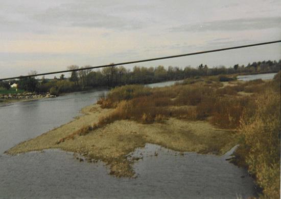
Smith River at Dr Fine Bridge
Future / Actual / Minor
OWP 2.0 WWA Modal Title
01/11/2021, 10:04 PM UTC through 01/11/2021, 10:04 PM UTC
Sender
Sent
- Downstream gauge unavailableWarning: no valid ratings curve available. Transformations to and from FEET/CFS/KCFS will not happen.
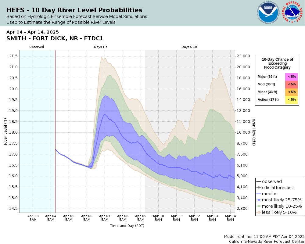
Traces and Thresholds Click to turn on/off display
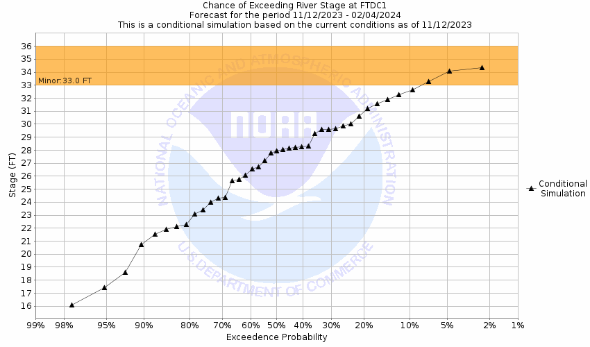
Observed (OBS) 06/17/2025 4:15 AM PDTRecord: 39.5 ftCATEGORY STAGE 
Major Flooding 39 ft Moderate Flooding 36 ft Minor Flooding 33 ft Action 27 ft Reliability of the Forecast: Based on current and forecast river, weather and reservoir conditions
NOTE: Forecasts are issued routinely year-round.
National Water Model Hydrograph
Official NWS streamflow forecasts are produced by NWS hydrologic forecasters for river gauge locations using hydrologic models which are calibrated to that location. This process considers additional guidance and information, including local expertise and experience, to produce the best forecast possible. The NWM output provides supplemental guidance to NWS forecasters and should not be considered an official NWS river forecast.
Flood Impacts
- 40 - Many roads and structures in the vicinity of the river are likely to be threatened. Significant flooding expected along US Highways 101 and 199, South Bank Rd, and in low lying areas between Lake Earl and the river, including areas along Lower Lake Drive.
- 38 - Expect flooding of portions of Highway 197 and South Bank Rd in the vicinity of US Highway 101. Flooding is also expected in low lying areas between Lake Earl and the river, including areas along Lower Lake Drive. Some access roads and homes in this area may be flooded.
- 36 - Flooding of South Bank Rd in the vicinity of US Highway 101 is likely. Water can flow across low-lying areas into Lake Earl about 4 miles south of the river, including areas along Lower Lake Drive. Some low-lying residential access roads may flood.
Gauge Info
| Coordinates | 41.8807, -124.136 |
| RFC | CNRFC |
| State | CA |
| WFO | EKA |
| County | Del Norte |
| Data Provider(s) | |
| US Geological Survey | USGS--Water Resources of the United States |
| USGS | 11532650 |
Gauge Location
Recent Crests
| 1. | 34.94 ft | on 01-13-2024 | (P) |
| 2. | 29.72 ft | on 03-13-2023 | |
| 3. | 27.11 ft | on 12-27-2022 | |
| 4. | 30.59 ft | on 01-13-2021 | |
| 5. | 26.14 ft | on 01-26-2020 |
Recent Crests
| 1. | 34.94 ft | on 01-13-2024 | (P) |
| 2. | 29.72 ft | on 03-13-2023 | |
| 3. | 27.11 ft | on 12-27-2022 | |
| 4. | 30.59 ft | on 01-13-2021 | |
| 5. | 26.14 ft | on 01-26-2020 | |
| 6. | 31.78 ft | on 04-09-2019 | |
| 7. | 29.56 ft | on 01-20-2019 | |
| 8. | 29.85 ft | on 01-11-2017 | |
| 9. | 30.77 ft | on 12-15-2016 | |
| 10. | 34.79 ft | on 12-13-2015 | |
| 11. | 29.63 ft | on 12-21-2014 | |
| 12. | 29.79 ft | on 02-14-2014 | |
| 13. | 30.65 ft | on 12-02-2012 | |
| 14. | 31.33 ft | on 03-30-2012 | |
| 15. | 32.36 ft | on 01-19-2012 | |
| 16. | 26.82 ft | on 12-29-2010 | |
| 17. | 27.40 ft | on 01-01-2010 | |
| 18. | 27.13 ft | on 12-30-1995 | |
| 19. | 30.00 ft | on 12-12-1995 | |
| 20. | 25.60 ft | on 03-20-1995 | |
| 21. | 30.71 ft | on 01-09-1995 | |
| 22. | 30.39 ft | on 01-20-1993 | |
| 23. | 28.40 ft | on 03-04-1991 | |
| 24. | 34.12 ft | on 01-08-1990 | |
| 25. | 29.40 ft | on 01-10-1989 | |
| 26. | 33.90 ft | on 11-22-1988 | |
| 27. | 26.90 ft | on 01-10-1988 | |
| 28. | 30.80 ft | on 12-10-1987 | |
| 29. | 26.70 ft | on 01-25-1987 | |
| 30. | 32.70 ft | on 02-22-1986 | |
| 31. | 29.50 ft | on 01-16-1986 | |
| 32. | 28.50 ft | on 11-12-1984 | |
| 33. | 30.40 ft | on 02-13-1984 | |
| 34. | 26.90 ft | on 12-30-1983 | |
| 35. | 29.00 ft | on 12-14-1983 | |
| 36. | 29.20 ft | on 12-06-1983 | |
| 37. | 31.60 ft | on 03-30-1983 | |
| 38. | 29.80 ft | on 02-18-1983 | |
| 39. | 27.20 ft | on 02-10-1983 | |
| 40. | 30.30 ft | on 01-26-1983 | |
| 41. | 30.30 ft | on 02-14-1982 | |
| 42. | 28.40 ft | on 03-14-1980 | |
| 43. | 28.40 ft | on 01-13-1980 | |
| 44. | 31.60 ft | on 12-14-1977 | |
| 45. | 29.60 ft | on 11-26-1977 | |
| 46. | 33.90 ft | on 03-18-1975 | |
| 47. | 32.70 ft | on 11-05-1973 | |
| 48. | 37.20 ft | on 03-03-1972 | |
| 49. | 37.10 ft | on 01-22-1972 | |
| 50. | 33.60 ft | on 01-17-1971 | |
| 51. | 33.20 ft | on 11-24-1970 | |
| 52. | 39.50 ft | on 12-22-1964 | |
| 53. | 37.40 ft | on 12-22-1955 | |
| 54. | 36.90 ft | on 10-29-1950 | |
| 55. | 35.04 ft | on 01-13-0024 | (P) |
| 56. | 27.34 ft | on 12-03-0023 | (P) |
Historic Crests
| 1. | 39.50 ft | on 12-22-1964 |
| 2. | 37.40 ft | on 12-22-1955 |
| 3. | 37.20 ft | on 03-03-1972 |
| 4. | 37.10 ft | on 01-22-1972 |
| 5. | 36.90 ft | on 10-29-1950 |
Historic Crests
| 1. | 39.50 ft | on 12-22-1964 | |
| 2. | 37.40 ft | on 12-22-1955 | |
| 3. | 37.20 ft | on 03-03-1972 | |
| 4. | 37.10 ft | on 01-22-1972 | |
| 5. | 36.90 ft | on 10-29-1950 | |
| 6. | 35.04 ft | on 01-13-0024 | (P) |
| 7. | 34.94 ft | on 01-13-2024 | (P) |
| 8. | 34.79 ft | on 12-13-2015 | |
| 9. | 34.12 ft | on 01-08-1990 | |
| 10. | 33.90 ft | on 03-18-1975 | |
| 11. | 33.90 ft | on 11-22-1988 | |
| 12. | 33.60 ft | on 01-17-1971 | |
| 13. | 33.20 ft | on 11-24-1970 | |
| 14. | 32.70 ft | on 11-05-1973 | |
| 15. | 32.70 ft | on 02-22-1986 | |
| 16. | 32.36 ft | on 01-19-2012 | |
| 17. | 31.78 ft | on 04-09-2019 | |
| 18. | 31.60 ft | on 12-14-1977 | |
| 19. | 31.60 ft | on 03-30-1983 | |
| 20. | 31.33 ft | on 03-30-2012 | |
| 21. | 30.80 ft | on 12-10-1987 | |
| 22. | 30.77 ft | on 12-15-2016 | |
| 23. | 30.71 ft | on 01-09-1995 | |
| 24. | 30.65 ft | on 12-02-2012 | |
| 25. | 30.59 ft | on 01-13-2021 | |
| 26. | 30.40 ft | on 02-13-1984 | |
| 27. | 30.39 ft | on 01-20-1993 | |
| 28. | 30.30 ft | on 01-26-1983 | |
| 29. | 30.30 ft | on 02-14-1982 | |
| 30. | 30.00 ft | on 12-12-1995 | |
| 31. | 29.85 ft | on 01-11-2017 | |
| 32. | 29.80 ft | on 02-18-1983 | |
| 33. | 29.79 ft | on 02-14-2014 | |
| 34. | 29.72 ft | on 03-13-2023 | |
| 35. | 29.63 ft | on 12-21-2014 | |
| 36. | 29.60 ft | on 11-26-1977 | |
| 37. | 29.56 ft | on 01-20-2019 | |
| 38. | 29.50 ft | on 01-16-1986 | |
| 39. | 29.40 ft | on 01-10-1989 | |
| 40. | 29.20 ft | on 12-06-1983 | |
| 41. | 29.00 ft | on 12-14-1983 | |
| 42. | 28.50 ft | on 11-12-1984 | |
| 43. | 28.40 ft | on 03-14-1980 | |
| 44. | 28.40 ft | on 03-04-1991 | |
| 45. | 28.40 ft | on 01-13-1980 | |
| 46. | 27.40 ft | on 01-01-2010 | |
| 47. | 27.34 ft | on 12-03-0023 | (P) |
| 48. | 27.20 ft | on 02-10-1983 | |
| 49. | 27.13 ft | on 12-30-1995 | |
| 50. | 27.11 ft | on 12-27-2022 | |
| 51. | 26.90 ft | on 01-10-1988 | |
| 52. | 26.90 ft | on 12-30-1983 | |
| 53. | 26.82 ft | on 12-29-2010 | |
| 54. | 26.70 ft | on 01-25-1987 | |
| 55. | 26.14 ft | on 01-26-2020 | |
| 56. | 25.60 ft | on 03-20-1995 |


Collaborative Agencies
The National Weather Service prepares its forecasts and other services in collaboration with agencies like the US Geological Survey, US Bureau of Reclamation, US Army Corps of Engineers, Natural Resource Conservation Service, National Park Service, ALERT Users Group, Bureau of Indian Affairs, and many state and local emergency managers across the country. For details, please click here.