Mendenhall River at Mendenhall Loop Road Bridge near Auke Bay
Future / Actual / Minor
OWP 2.0 WWA Modal Title
01/11/2021, 10:04 PM UTC through 01/11/2021, 10:04 PM UTC
Sender
Sent
- Downstream gauge unavailableNWS gage discontinued. See USGS gage MNDA2 for observations.
Official
CATEGORY STAGE 
Moderate Flooding 12.5 ft Minor Flooding 11.5 ft Action 10.5 ft - NWS gage discontinued. See USGS gage MNDA2 for observations.
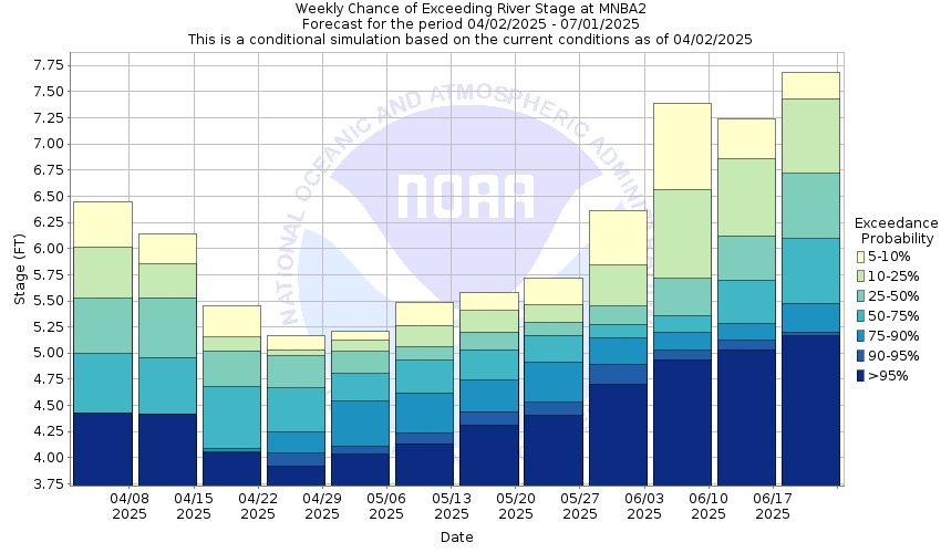
National Water Model Hydrograph
Official NWS streamflow forecasts are produced by NWS hydrologic forecasters for river gauge locations using hydrologic models which are calibrated to that location. This process considers additional guidance and information, including local expertise and experience, to produce the best forecast possible. The NWM output provides supplemental guidance to NWS forecasters and should not be considered an official NWS river forecast.
Flood Impacts
- 13 - View Drive will be flooded and impassable.
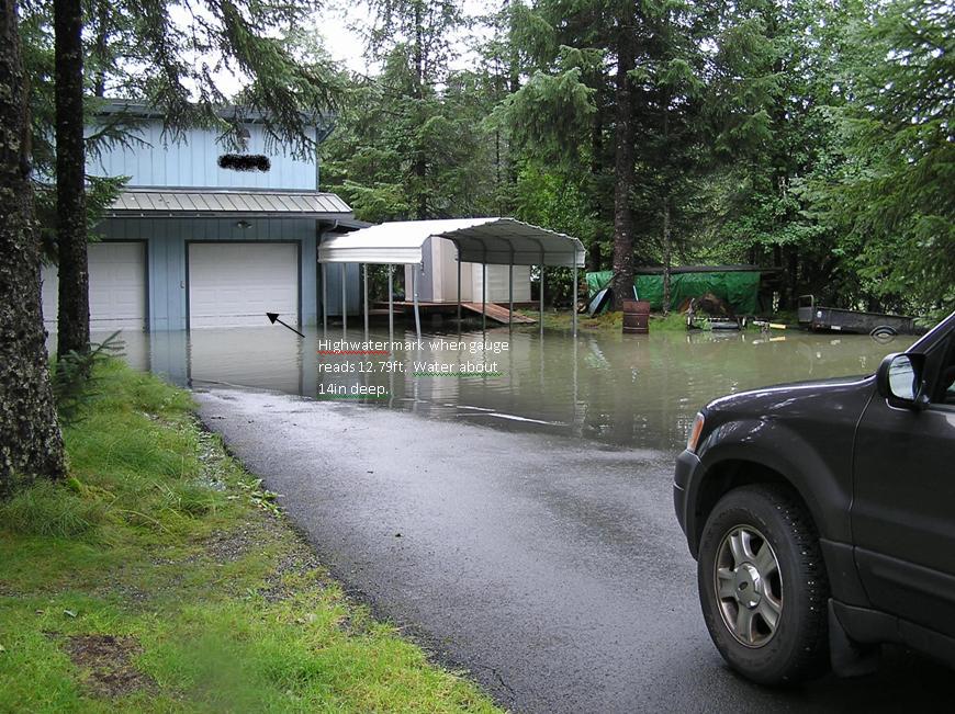
- 12.5 - Some homes along View Drive will have as much as 1.5 ft of water in garages and up to 3 ft in yards. This is moderate flooding.
- 11.5 - The yards and property of houses along View Drive start to become inundated causing minor flooding.
Gauge Info
| Coordinates | 58.4042, -134.584 |
| RFC | APRFC |
| State | AK |
| WFO | AJK |
| County | Juneau |
| Data Provider(s) | |
| National Weather Service | Alaska-Pacific River Forecast Center |
| US Geological Survey | USGS 15052580 |
Gauge Location
Recent Crests
| 1. | 10.02 ft | on 09-08-2013 |
| 2. | 12.24 ft | on 08-23-2011 |
| 3. | 13.07 ft | on 07-22-2011 |
| 4. | 12.80 ft | on 08-18-2009 |
| 5. | 10.43 ft | on 10-02-2008 |
Recent Crests
| 1. | 10.02 ft | on 09-08-2013 |
| 2. | 12.24 ft | on 08-23-2011 |
| 3. | 13.07 ft | on 07-22-2011 |
| 4. | 12.80 ft | on 08-18-2009 |
| 5. | 10.43 ft | on 10-02-2008 |
| 6. | 10.34 ft | on 07-14-2007 |
| 7. | 12.03 ft | on 09-02-2006 |
| 8. | 10.40 ft | on 08-06-2005 |
| 9. | 10.47 ft | on 07-30-2004 |
| 10. | 11.05 ft | on 08-17-2003 |
| 11. | 10.15 ft | on 09-15-2001 |
| 12. | 10.47 ft | on 08-22-2000 |
| 13. | 10.24 ft | on 09-19-1999 |
| 14. | 12.00 ft | on 10-20-1998 |
| 15. | 10.60 ft | on 08-14-1997 |
| 16. | 10.11 ft | on 09-26-1996 |
| 17. | 13.75 ft | on 09-11-1995 |
Historic Crests
| 1. | 13.75 ft | on 09-11-1995 |
| 2. | 13.07 ft | on 07-22-2011 |
| 3. | 12.80 ft | on 08-18-2009 |
| 4. | 12.24 ft | on 08-23-2011 |
| 5. | 12.03 ft | on 09-02-2006 |
Historic Crests
| 1. | 13.75 ft | on 09-11-1995 |
| 2. | 13.07 ft | on 07-22-2011 |
| 3. | 12.80 ft | on 08-18-2009 |
| 4. | 12.24 ft | on 08-23-2011 |
| 5. | 12.03 ft | on 09-02-2006 |
| 6. | 12.00 ft | on 10-20-1998 |
| 7. | 11.05 ft | on 08-17-2003 |
| 8. | 10.60 ft | on 08-14-1997 |
| 9. | 10.47 ft | on 07-30-2004 |
| 10. | 10.47 ft | on 08-22-2000 |
| 11. | 10.43 ft | on 10-02-2008 |
| 12. | 10.40 ft | on 08-06-2005 |
| 13. | 10.34 ft | on 07-14-2007 |
| 14. | 10.24 ft | on 09-19-1999 |
| 15. | 10.15 ft | on 09-15-2001 |
| 16. | 10.11 ft | on 09-26-1996 |
| 17. | 10.02 ft | on 09-08-2013 |
Vertical Datum Table
| type | STND | NGVD29 |
|---|---|---|
| major Flooding | N/A | N/A |
| moderate Flooding | 12.50 ft | 53.10 ft |
| minor Flooding | 11.50 ft | 52.10 ft |
| action | 10.50 ft | 51.10 ft |
| Latest Value | N/A | N/A |
| Gauge Zero | 0.00 ft | 40.60 ft |


Unique Local Info
Collaborative Agencies
The National Weather Service prepares its forecasts and other services in collaboration with agencies like the US Geological Survey, US Bureau of Reclamation, US Army Corps of Engineers, Natural Resource Conservation Service, National Park Service, ALERT Users Group, Bureau of Indian Affairs, and many state and local emergency managers across the country. For details, please click here.