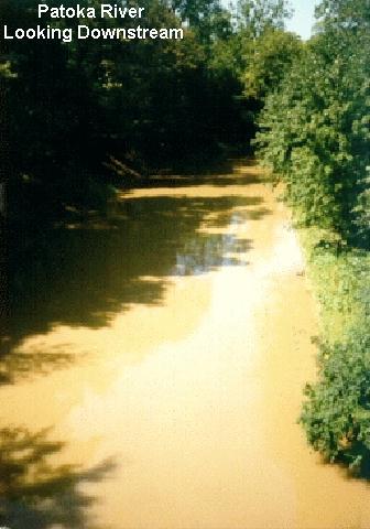
Patoka River at Princeton
Future / Actual / Minor
OWP 2.0 WWA Modal Title
01/11/2021, 10:04 PM UTC through 01/11/2021, 10:04 PM UTC
Sender
Sent
- Warning: no valid ratings curve available. Transformations to and from FEET/CFS/KCFS will not happen.
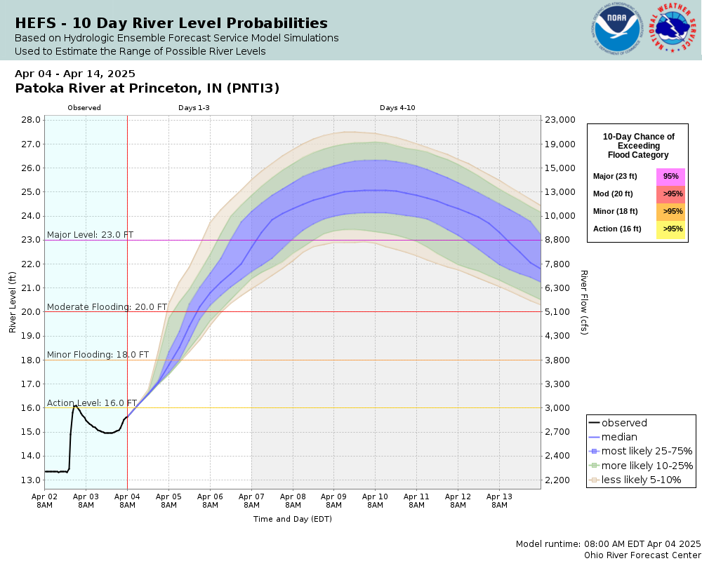
Traces and Thresholds Click to turn on/off display
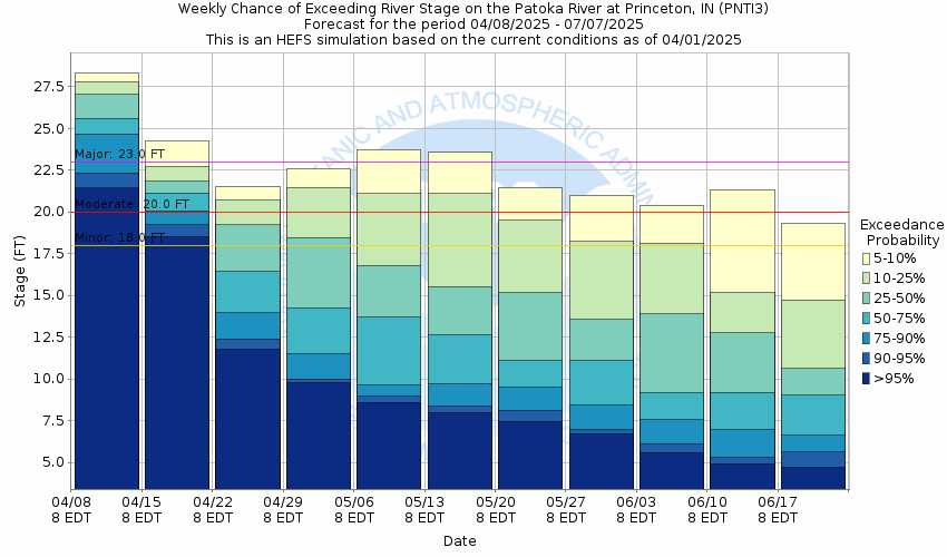
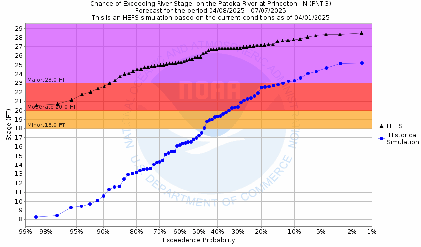
Observed (OBS) 04/01/2025 6:45 AM CDTRecord: 24.9 ftLow Threshold: 2.5 ftCATEGORY STAGE 
Major Flooding 23 ft Moderate Flooding 20 ft Minor Flooding 18 ft Action 16 ft Reliability of the Forecast:
NOTE: Forecasts are issued as needed during times of high water, but are not routinely available.
River forecasts for this location take into account past precipitation and the precipitation amounts expected approximately 48 hours into the future from the forecast issuance time.
National Water Model Hydrograph
Official NWS streamflow forecasts are produced by NWS hydrologic forecasters for river gauge locations using hydrologic models which are calibrated to that location. This process considers additional guidance and information, including local expertise and experience, to produce the best forecast possible. The NWM output provides supplemental guidance to NWS forecasters and should not be considered an official NWS river forecast.
Flood Impacts
- 22 - Flooding affects mainly farmland. Seasonal camping trailers closest to the river become inundated.
Gauge Info
| Coordinates | 38.3903, -87.5489 |
| RFC | OHRFC |
| State | IN |
| WFO | PAH |
| County | Gibson |
| Data Provider(s) | |
| US Geological Survey | USGS--Water Resources of the United States |
| USGS | 03376500 |
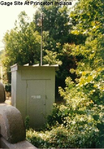
Gauge Location
Recent Crests
| 1. | 19.23 ft | on 04-06-2023 |
| 2. | 18.69 ft | on 03-12-2023 |
| 3. | 19.27 ft | on 03-01-2022 |
| 4. | 20.83 ft | on 01-18-2020 |
| 5. | 22.24 ft | on 06-24-2019 |
Recent Crests
| 1. | 19.23 ft | on 04-06-2023 |
| 2. | 18.69 ft | on 03-12-2023 |
| 3. | 19.27 ft | on 03-01-2022 |
| 4. | 20.83 ft | on 01-18-2020 |
| 5. | 22.24 ft | on 06-24-2019 |
| 6. | 22.79 ft | on 03-02-2018 |
| 7. | 24.30 ft | on 05-06-2017 |
| 8. | 18.19 ft | on 01-05-2016 |
| 9. | 22.57 ft | on 04-10-2015 |
| 10. | 22.33 ft | on 04-10-2014 |
| 11. | 21.08 ft | on 12-27-2013 |
| 12. | 24.89 ft | on 05-04-2011 |
| 13. | 24.11 ft | on 03-25-2008 |
| 14. | 20.48 ft | on 01-21-2007 |
| 15. | 24.00 ft | on 03-16-2006 |
| 16. | 22.60 ft | on 01-11-2005 |
| 17. | 18.32 ft | on 03-02-2003 |
| 18. | 23.17 ft | on 05-17-2002 |
| 19. | 19.53 ft | on 02-27-2000 |
| 20. | 18.92 ft | on 02-01-1999 |
| 21. | 20.18 ft | on 05-09-1998 |
| 22. | 24.35 ft | on 05-04-1996 |
| 23. | 21.20 ft | on 05-25-1995 |
| 24. | 21.64 ft | on 11-21-1993 |
| 25. | 22.42 ft | on 05-23-1990 |
Historic Crests
| 1. | 24.89 ft | on 05-04-2011 |
| 2. | 24.35 ft | on 05-04-1996 |
| 3. | 24.30 ft | on 05-06-2017 |
| 4. | 24.11 ft | on 03-25-2008 |
| 5. | 24.00 ft | on 03-16-2006 |
Historic Crests
| 1. | 24.89 ft | on 05-04-2011 |
| 2. | 24.35 ft | on 05-04-1996 |
| 3. | 24.30 ft | on 05-06-2017 |
| 4. | 24.11 ft | on 03-25-2008 |
| 5. | 24.00 ft | on 03-16-2006 |
| 6. | 23.17 ft | on 05-17-2002 |
| 7. | 22.79 ft | on 03-02-2018 |
| 8. | 22.60 ft | on 01-11-2005 |
| 9. | 22.57 ft | on 04-10-2015 |
| 10. | 22.42 ft | on 05-23-1990 |
| 11. | 22.33 ft | on 04-10-2014 |
| 12. | 22.24 ft | on 06-24-2019 |
| 13. | 21.64 ft | on 11-21-1993 |
| 14. | 21.20 ft | on 05-25-1995 |
| 15. | 21.08 ft | on 12-27-2013 |
| 16. | 20.83 ft | on 01-18-2020 |
| 17. | 20.48 ft | on 01-21-2007 |
| 18. | 20.18 ft | on 05-09-1998 |
| 19. | 19.53 ft | on 02-27-2000 |
| 20. | 19.27 ft | on 03-01-2022 |
| 21. | 19.23 ft | on 04-06-2023 |
| 22. | 18.92 ft | on 02-01-1999 |
| 23. | 18.69 ft | on 03-12-2023 |
| 24. | 18.32 ft | on 03-02-2003 |
| 25. | 18.19 ft | on 01-05-2016 |
Vertical Datum Table
| type | NAVD88 |
|---|---|
| major Flooding | 411.56 ft |
| moderate Flooding | 408.56 ft |
| minor Flooding | 406.56 ft |
| action | 404.56 ft |
| Latest Value | 401.98 ft |
| Gauge Zero | 388.56 ft |


Unique Local Info
Collaborative Agencies
The National Weather Service prepares its forecasts and other services in collaboration with agencies like the US Geological Survey, US Bureau of Reclamation, US Army Corps of Engineers, Natural Resource Conservation Service, National Park Service, ALERT Users Group, Bureau of Indian Affairs, and many state and local emergency managers across the country. For details, please click here.
Resources
Hydrologic Resource Links
- River Forecast Centers
- Text Products
- Past Precipitation
- Forecast Precipitation
- National Precipitation Graphics
- Water Resources Outlook - Ohio River Valley
- Excessive Rainfall Outlook
- Inundation Mapping Locations
- OHRFC Ensemble River Forecasts
- NCRFC Ensemble River Forecasts
- LMRFC Ensemble River Forecasts
- Add'l Mississippi/Ohio River Information
- ** 28-Day Mississippi/Ohio River Forecasts **
Additional Resource Links
- NWS Precipitation and River Forecasting
- Area Hydrographs
- Snow Information
- Drought Information
- U.S. Water Monitor
- USGS WaterWatch
- USGS WaterAlert
- USACE RiverGages
- TVA Lake Information
- Midwest Regional Climate Center
- Additional Precipitation Information
- CoCoRaHS Precipitation
- Precipitation Frequencies