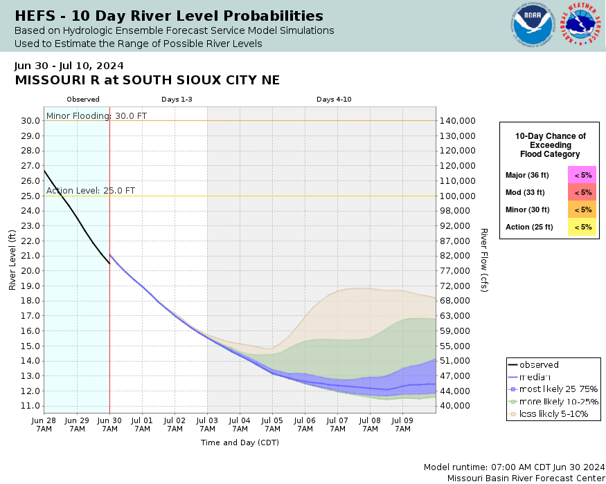
Missouri River at Sioux City
Future / Actual / Minor
OWP 2.0 WWA Modal Title
01/11/2021, 10:04 PM UTC through 01/11/2021, 10:04 PM UTC
Sender
Sent
- Warning: no valid ratings curve available. Transformations to and from FEET/CFS/KCFS will not happen.
Traces and Thresholds Click to turn on/off display
Observed (OBS) 07/03/2025 8:00 PM CDTOfficial Forecast (FCST) 07/03/2025 9:07 AM CDTRecord: 35.3 ftLow Threshold: 4 ftCATEGORY STAGE 
Major Flooding 36 ft Moderate Flooding 33 ft Minor Flooding 30 ft Action 25 ft Reliability of the Forecast:
NOTE: Forecasts are issued routinely year-round.
River forecasts for this location take into account past and future precipitation. The stages/flows that will occur may be different if future rainfall is different than forecast.
Gauge reading affected by reservoir operations.
National Water Model Hydrograph
Official NWS streamflow forecasts are produced by NWS hydrologic forecasters for river gauge locations using hydrologic models which are calibrated to that location. This process considers additional guidance and information, including local expertise and experience, to produce the best forecast possible. The NWM output provides supplemental guidance to NWS forecasters and should not be considered an official NWS river forecast.
Flood Impacts
- 39 - Water reaches portions of 4th St in South Sioux City near the gauge location under the Hwy 20 bridge.
- 36 - Extensive urban flooding in lower lying portions of Sioux City begins.
- 35 - The levee protecting various structures in parks and memorials on the Iowa side of the river is overtopped.
- 33 - Additional recreational areas and some pasture land along the river begin to flood.
- 32 - Hamilton Blvd under I-29 is flooded.
Gauge Location
Recent Crests
| 1. | 32.23 ft | on 06-24-2024 |
| 2. | 13.76 ft | on 09-21-2023 |
| 3. | 12.87 ft | on 08-16-2022 |
| 4. | 18.12 ft | on 04-01-2020 |
| 5. | 25.92 ft | on 10-21-2019 |
Recent Crests
| 1. | 32.23 ft | on 06-24-2024 | |
| 2. | 13.76 ft | on 09-21-2023 | |
| 3. | 12.87 ft | on 08-16-2022 | |
| 4. | 18.12 ft | on 04-01-2020 | |
| 5. | 25.92 ft | on 10-21-2019 | |
| 6. | 30.27 ft | on 06-01-2019 | |
| 7. | 29.78 ft | on 03-17-2019 | |
| 8. | 25.69 ft | on 09-22-2018 | |
| 9. | 25.91 ft | on 06-26-2018 | |
| 10. | 16.65 ft | on 05-29-2017 | |
| 11. | 15.21 ft | on 06-18-2016 | |
| 12. | 17.44 ft | on 10-02-2014 | |
| 13. | 23.97 ft | on 06-20-2014 | |
| 14. | 16.57 ft | on 05-28-2013 | |
| 15. | 15.46 ft | on 05-12-2012 | |
| 16. | 35.25 ft | on 07-21-2011 | |
| 17. | 25.49 ft | on 09-30-2010 | |
| 18. | 19.04 ft | on 07-10-2009 | |
| 19. | 18.19 ft | on 06-11-2008 | |
| 20. | 18.58 ft | on 03-13-2007 | |
| 21. | 16.89 ft | on 04-12-2006 | |
| 22. | 17.91 ft | on 06-09-2005 | |
| 23. | 17.89 ft | on 05-30-2004 | |
| 24. | 16.83 ft | on 09-11-2003 | |
| 25. | 16.55 ft | on 08-22-2002 | |
| 26. | 22.36 ft | on 04-28-2001 | |
| 27. | 18.82 ft | on 10-02-1999 | |
| 28. | 20.93 ft | on 07-22-1999 | |
| 29. | 23.24 ft | on 10-13-1997 | |
| 30. | 25.83 ft | on 04-08-1997 | |
| 31. | 27.55 ft | on 07-17-1996 | |
| 32. | 25.14 ft | on 06-01-1995 | |
| 33. | 22.24 ft | on 06-17-1994 | |
| 34. | 27.33 ft | on 07-15-1993 | |
| 35. | 19.90 ft | on 07-12-1992 | |
| 36. | 19.04 ft | on 06-01-1991 | |
| 37. | 20.77 ft | on 05-19-1990 | |
| 38. | 19.20 ft | on 07-18-1989 | |
| 39. | 19.96 ft | on 09-15-1988 | |
| 40. | 23.19 ft | on 10-01-1986 | |
| 41. | 23.91 ft | on 05-17-1986 | |
| 42. | 23.94 ft | on 04-23-1985 | |
| 43. | 30.77 ft | on 06-25-1984 | |
| 44. | 22.78 ft | on 11-24-1982 | |
| 45. | 19.81 ft | on 10-14-1981 | |
| 46. | 20.97 ft | on 06-14-1981 | |
| 47. | 20.53 ft | on 10-31-1979 | |
| 48. | 23.48 ft | on 11-05-1978 | |
| 49. | 25.42 ft | on 07-23-1978 | |
| 50. | 24.02 ft | on 11-20-1976 | |
| 51. | 25.59 ft | on 10-08-1975 | |
| 52. | 26.66 ft | on 08-26-1975 | |
| 53. | 21.75 ft | on 08-01-1974 | |
| 54. | 23.76 ft | on 10-06-1972 | |
| 55. | 25.06 ft | on 07-21-1972 | |
| 56. | 30.65 ft | on 02-19-1971 | 1 |
| 57. | 25.47 ft | on 10-01-1969 | |
| 58. | 27.58 ft | on 04-10-1969 | 1 |
| 59. | 25.27 ft | on 07-24-1968 | 1 |
| 60. | 25.09 ft | on 07-25-1967 | 1 |
| 61. | 26.00 ft | on 07-27-1966 | 1 |
| 62. | 25.67 ft | on 08-21-1965 | 1 |
| 63. | 26.26 ft | on 08-06-1964 | 1 |
| 64. | 26.00 ft | on 06-02-1963 | 1 |
| 65. | 28.60 ft | on 03-28-1962 | 1 |
| 66. | 25.77 ft | on 08-10-1961 | 1 |
| 67. | 30.52 ft | on 04-03-1960 | 1 |
| 68. | 26.50 ft | on 05-31-1959 | 1 |
| 69. | 27.28 ft | on 07-02-1958 | 1 |
| 70. | 26.43 ft | on 06-25-1957 | 1 |
| 71. | 27.10 ft | on 08-18-1956 | 1 |
| 72. | 26.19 ft | on 07-10-1955 | 1 |
| 73. | 26.83 ft | on 06-21-1954 | 1 |
| 74. | 29.19 ft | on 06-25-1953 | 1 |
Historic Crests
| 1. | 35.25 ft | on 07-21-2011 | |
| 2. | 32.23 ft | on 06-24-2024 | |
| 3. | 30.77 ft | on 06-25-1984 | |
| 4. | 30.65 ft | on 02-19-1971 | 1 |
| 5. | 30.52 ft | on 04-03-1960 | 1 |
Historic Crests
| 1. | 35.25 ft | on 07-21-2011 | |
| 2. | 32.23 ft | on 06-24-2024 | |
| 3. | 30.77 ft | on 06-25-1984 | |
| 4. | 30.65 ft | on 02-19-1971 | 1 |
| 5. | 30.52 ft | on 04-03-1960 | 1 |
| 6. | 30.27 ft | on 06-01-2019 | |
| 7. | 29.78 ft | on 03-17-2019 | |
| 8. | 29.19 ft | on 06-25-1953 | 1 |
| 9. | 28.60 ft | on 03-28-1962 | 1 |
| 10. | 27.58 ft | on 04-10-1969 | 1 |
| 11. | 27.55 ft | on 07-17-1996 | |
| 12. | 27.33 ft | on 07-15-1993 | |
| 13. | 27.28 ft | on 07-02-1958 | 1 |
| 14. | 27.10 ft | on 08-18-1956 | 1 |
| 15. | 26.83 ft | on 06-21-1954 | 1 |
| 16. | 26.66 ft | on 08-26-1975 | |
| 17. | 26.50 ft | on 05-31-1959 | 1 |
| 18. | 26.43 ft | on 06-25-1957 | 1 |
| 19. | 26.26 ft | on 08-06-1964 | 1 |
| 20. | 26.19 ft | on 07-10-1955 | 1 |
| 21. | 26.00 ft | on 07-27-1966 | 1 |
| 22. | 26.00 ft | on 06-02-1963 | 1 |
| 23. | 25.92 ft | on 10-21-2019 | |
| 24. | 25.91 ft | on 06-26-2018 | |
| 25. | 25.83 ft | on 04-08-1997 | |
| 26. | 25.77 ft | on 08-10-1961 | 1 |
| 27. | 25.69 ft | on 09-22-2018 | |
| 28. | 25.67 ft | on 08-21-1965 | 1 |
| 29. | 25.59 ft | on 10-08-1975 | |
| 30. | 25.49 ft | on 09-30-2010 | |
| 31. | 25.47 ft | on 10-01-1969 | |
| 32. | 25.42 ft | on 07-23-1978 | |
| 33. | 25.27 ft | on 07-24-1968 | 1 |
| 34. | 25.14 ft | on 06-01-1995 | |
| 35. | 25.09 ft | on 07-25-1967 | 1 |
| 36. | 25.06 ft | on 07-21-1972 | |
| 37. | 24.02 ft | on 11-20-1976 | |
| 38. | 23.97 ft | on 06-20-2014 | |
| 39. | 23.94 ft | on 04-23-1985 | |
| 40. | 23.91 ft | on 05-17-1986 | |
| 41. | 23.76 ft | on 10-06-1972 | |
| 42. | 23.48 ft | on 11-05-1978 | |
| 43. | 23.24 ft | on 10-13-1997 | |
| 44. | 23.19 ft | on 10-01-1986 | |
| 45. | 22.78 ft | on 11-24-1982 | |
| 46. | 22.36 ft | on 04-28-2001 | |
| 47. | 22.24 ft | on 06-17-1994 | |
| 48. | 21.75 ft | on 08-01-1974 | |
| 49. | 20.97 ft | on 06-14-1981 | |
| 50. | 20.93 ft | on 07-22-1999 | |
| 51. | 20.77 ft | on 05-19-1990 | |
| 52. | 20.53 ft | on 10-31-1979 | |
| 53. | 19.96 ft | on 09-15-1988 | |
| 54. | 19.90 ft | on 07-12-1992 | |
| 55. | 19.81 ft | on 10-14-1981 | |
| 56. | 19.20 ft | on 07-18-1989 | |
| 57. | 19.04 ft | on 06-01-1991 | |
| 58. | 19.04 ft | on 07-10-2009 | |
| 59. | 18.82 ft | on 10-02-1999 | |
| 60. | 18.58 ft | on 03-13-2007 | |
| 61. | 18.19 ft | on 06-11-2008 | |
| 62. | 18.12 ft | on 04-01-2020 | |
| 63. | 17.91 ft | on 06-09-2005 | |
| 64. | 17.89 ft | on 05-30-2004 | |
| 65. | 17.44 ft | on 10-02-2014 | |
| 66. | 16.89 ft | on 04-12-2006 | |
| 67. | 16.83 ft | on 09-11-2003 | |
| 68. | 16.65 ft | on 05-29-2017 | |
| 69. | 16.57 ft | on 05-28-2013 | |
| 70. | 16.55 ft | on 08-22-2002 | |
| 71. | 15.46 ft | on 05-12-2012 | |
| 72. | 15.21 ft | on 06-18-2016 | |
| 73. | 13.76 ft | on 09-21-2023 | |
| 74. | 12.87 ft | on 08-16-2022 |
Vertical Datum Table
| type | NAVD88 |
|---|---|
| major Flooding | 1093.42 ft |
| moderate Flooding | 1090.42 ft |
| minor Flooding | 1087.42 ft |
| action | 1082.42 ft |
| Latest Value | 1068.88 ft |
| Gauge Zero | 1057.42 ft |


Unique Local Info
USGS 7-Day Streamflow Historical Comparison USGS WaterWatch Webpage
USACE Missouri River Basin Weekly Update
Crest History values prior to 1981 from gauge location 227 ft downstream and at different datum. Values from prior to 1957 from pre-regulation period when Gavins Point Dam was completed. Peak stage pre-regulation of 44.28 ft in April 1952.
Collaborative Agencies
The National Weather Service prepares its forecasts and other services in collaboration with agencies like the US Geological Survey, US Bureau of Reclamation, US Army Corps of Engineers, Natural Resource Conservation Service, National Park Service, ALERT Users Group, Bureau of Indian Affairs, and many state and local emergency managers across the country. For details, please click here.
Resources
Hydrologic Resource Links
- River Forecast Centers
- NWS Sioux Falls Flooding Resource Page
- NOHRSC Snow Information
- USACE Missouri River Water Management
- USGS National Water Dashboard
- FEMA Flood Insurance Information
- South Dakota Flood Information System
- Iowa Flood Information System
- Missouri River Flood Information System
- Minnesota DNR
- Nebraska Real-Time Flood Forecasting
- ___