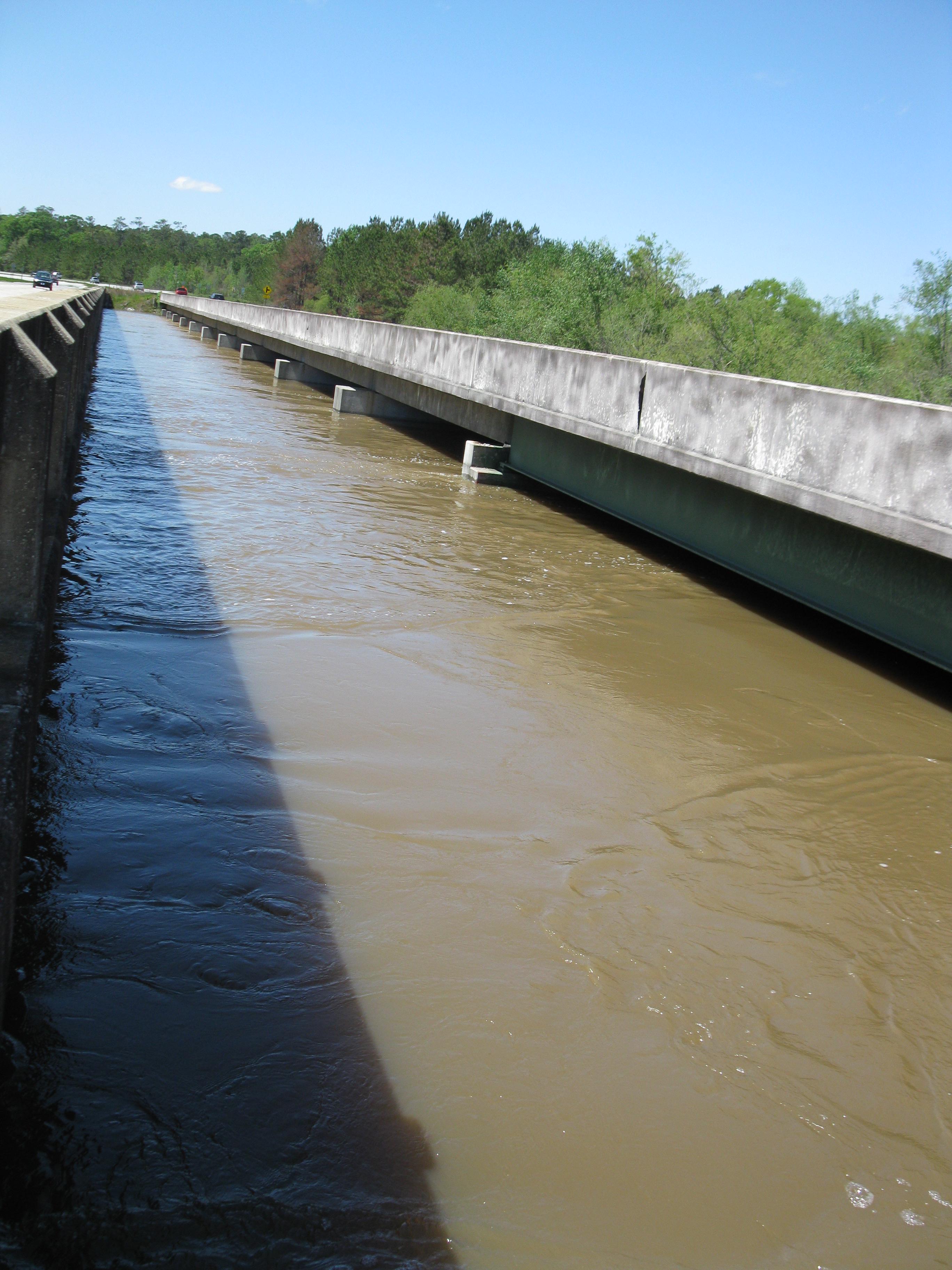
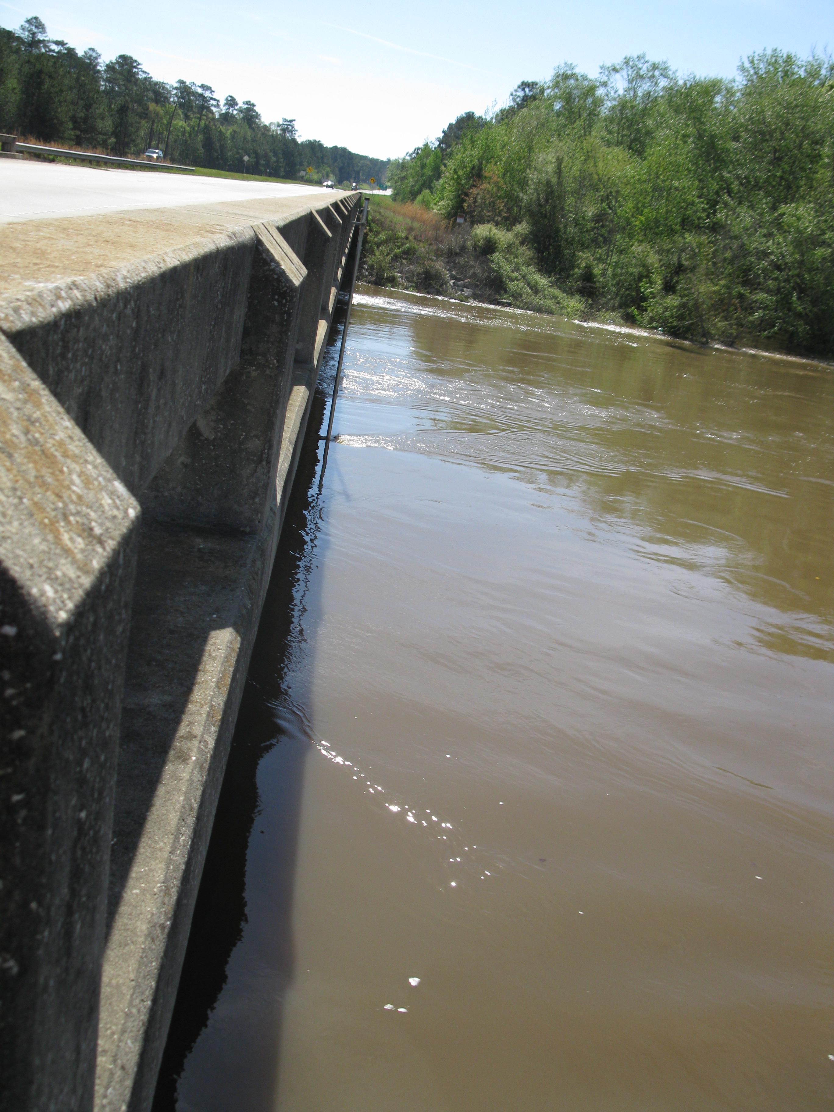
Ochlockonee River near Thomasville (US 84)
Future / Actual / Minor
OWP 2.0 WWA Modal Title
01/11/2021, 10:04 PM UTC through 01/11/2021, 10:04 PM UTC
Sender
Sent
- Warning: no valid ratings curve available. Transformations to and from FEET/CFS/KCFS will not happen.
Traces and Thresholds Click to turn on/off display
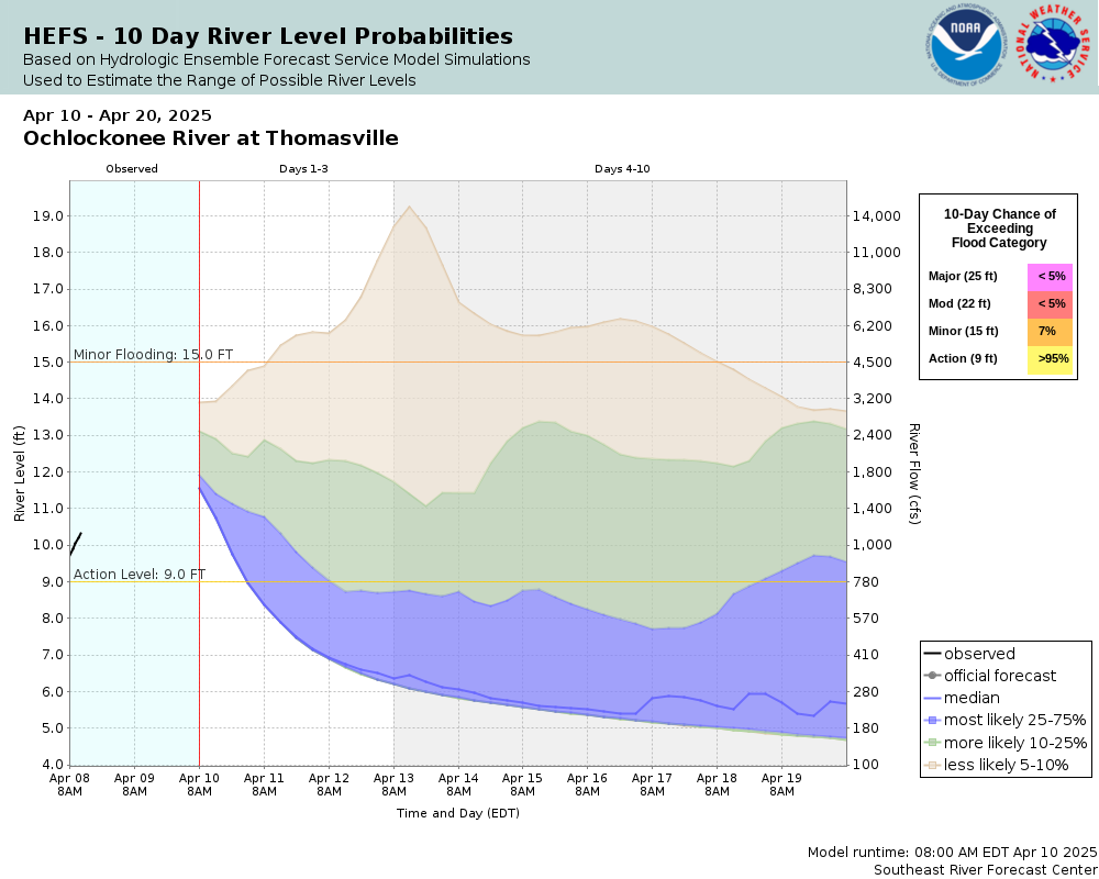
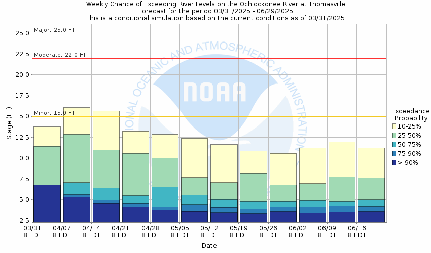
Observed (OBS) 06/21/2025 12:45 AM EDTRecord: 29.1 ftLow Threshold: 2.8 ftCATEGORY STAGE 
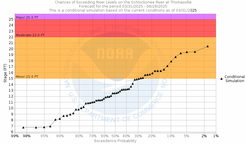
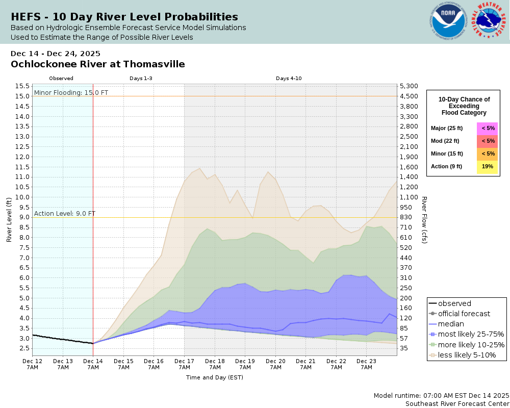
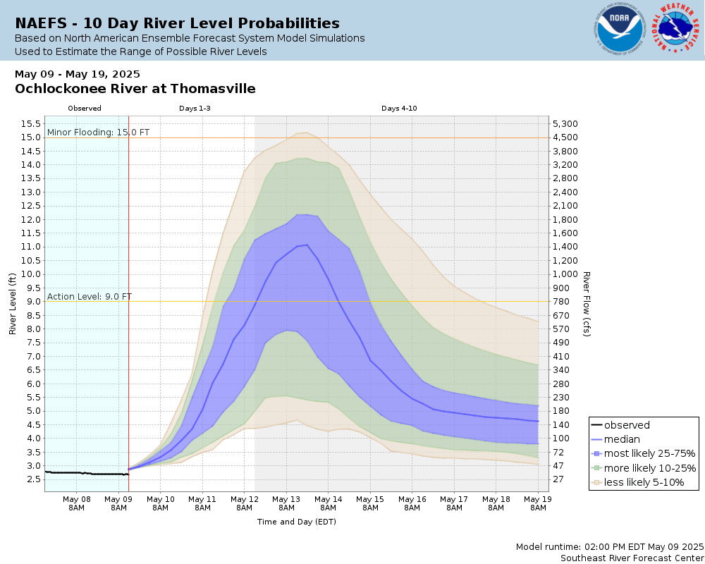
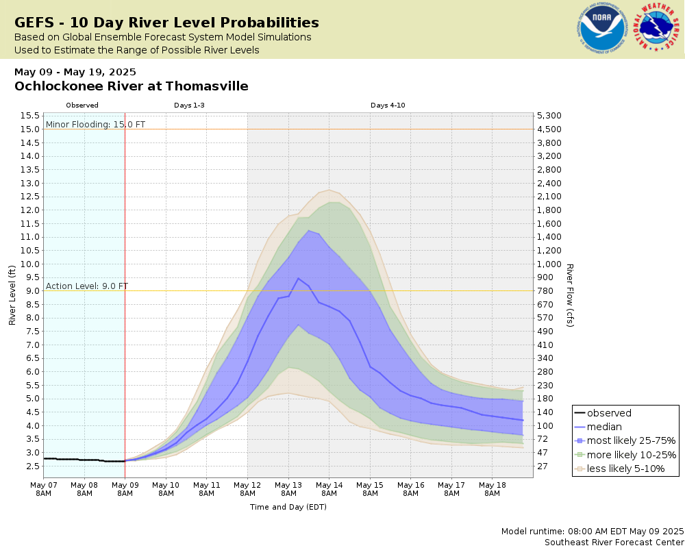
Major Flooding 25 ft Moderate Flooding 22 ft Minor Flooding 15 ft Action 9 ft Reliability of the Forecast:
NOTE: Forecasts are issued as needed during times of high water, but are not routinely available.
River forecasts for this location take into account past precipitation and the precipitation amounts expected approximately 48 hours into the future from the forecast issuance time.
National Water Model Hydrograph
Official NWS streamflow forecasts are produced by NWS hydrologic forecasters for river gauge locations using hydrologic models which are calibrated to that location. This process considers additional guidance and information, including local expertise and experience, to produce the best forecast possible. The NWM output provides supplemental guidance to NWS forecasters and should not be considered an official NWS river forecast.
Flood Impacts
- 31 - In Thomas County, water overtops the US-84 bridge. The southbound approach to the GA-3 bridge floods at this level.
- 30 - In Thomas County, water overtops the US-19 bridge.
- 29 - In Thomas County, water reaches the road surface of US-19 on the south side of the river. In Grady County, the GA-93 bridge is overtopped at this level.
Gauge Info
| Coordinates | 30.8756, -84.0456 |
| RFC | SERFC |
| State | GA |
| WFO | TAE |
| County | Thomas |
| Data Provider(s) | |
| US Geological Survey | USGS--Water Resources of the United States |
| USGS | 02327500 |
Gauge Location
Recent Crests
| 1. | 14.34 ft | on 03-30-2024 |
| 2. | 16.69 ft | on 01-04-2021 |
| 3. | 13.79 ft | on 03-09-2020 |
| 4. | 11.41 ft | on 02-29-2020 |
| 5. | 15.82 ft | on 12-17-2018 |
Recent Crests
| 1. | 14.34 ft | on 03-30-2024 |
| 2. | 16.69 ft | on 01-04-2021 |
| 3. | 13.79 ft | on 03-09-2020 |
| 4. | 11.41 ft | on 02-29-2020 |
| 5. | 15.82 ft | on 12-17-2018 |
| 6. | 17.45 ft | on 12-04-2018 |
| 7. | 11.32 ft | on 11-18-2018 |
| 8. | 12.15 ft | on 02-16-2018 |
| 9. | 15.80 ft | on 01-23-2017 |
| 10. | 12.23 ft | on 01-07-2017 |
| 11. | 10.61 ft | on 12-10-2016 |
| 12. | 9.98 ft | on 09-05-2016 |
| 13. | 19.92 ft | on 04-03-2016 |
| 14. | 15.13 ft | on 03-29-2016 |
| 15. | 13.29 ft | on 02-27-2016 |
| 16. | 14.91 ft | on 02-06-2016 |
| 17. | 20.52 ft | on 12-25-2014 |
| 18. | 16.49 ft | on 04-20-2014 |
| 19. | 15.27 ft | on 04-11-2014 |
| 20. | 16.33 ft | on 03-19-2014 |
| 21. | 17.40 ft | on 08-19-2013 |
| 22. | 22.12 ft | on 02-27-2013 |
| 23. | 23.83 ft | on 04-03-2009 |
| 24. | 19.89 ft | on 03-30-2009 |
| 25. | 17.05 ft | on 08-24-2008 |
| 26. | 15.01 ft | on 02-27-2008 |
| 27. | 19.36 ft | on 02-24-2008 |
| 28. | 16.34 ft | on 03-28-2005 |
| 29. | 16.34 ft | on 03-28-2005 |
| 30. | 16.00 ft | on 02-16-1997 |
| 31. | 17.40 ft | on 02-13-1995 |
| 32. | 21.60 ft | on 10-04-1994 |
| 33. | 16.70 ft | on 08-18-1994 |
| 34. | 15.02 ft | on 03-28-1994 |
| 35. | 17.40 ft | on 01-15-1993 |
| 36. | 16.43 ft | on 02-20-1992 |
| 37. | 15.50 ft | on 06-30-1991 |
| 38. | 22.50 ft | on 03-30-1991 |
| 39. | 17.70 ft | on 02-01-1991 |
| 40. | 15.90 ft | on 01-11-1990 |
| 41. | 22.00 ft | on 02-12-1986 |
| 42. | 22.80 ft | on 03-08-1984 |
| 43. | 20.70 ft | on 04-12-1975 |
| 44. | 16.20 ft | on 01-14-1972 |
| 45. | 17.10 ft | on 03-28-1971 |
| 46. | 15.02 ft | on 01-05-1967 |
| 47. | 16.01 ft | on 03-06-1966 |
| 48. | 16.80 ft | on 02-15-1965 |
| 49. | 20.40 ft | on 12-05-1964 |
| 50. | 18.80 ft | on 05-03-1964 |
| 51. | 17.00 ft | on 03-05-1964 |
| 52. | 20.80 ft | on 04-17-1961 |
| 53. | 18.00 ft | on 04-04-1960 |
| 54. | 19.30 ft | on 03-07-1959 |
| 55. | 17.40 ft | on 04-11-1958 |
| 56. | 15.60 ft | on 04-14-1953 |
| 57. | 29.10 ft | on 04-02-1948 |
| 58. | 17.00 ft | on 04-17-1947 |
Historic Crests
| 1. | 29.10 ft | on 04-02-1948 |
| 2. | 23.83 ft | on 04-03-2009 |
| 3. | 22.80 ft | on 03-08-1984 |
| 4. | 22.50 ft | on 03-30-1991 |
| 5. | 22.12 ft | on 02-27-2013 |
Historic Crests
| 1. | 29.10 ft | on 04-02-1948 |
| 2. | 23.83 ft | on 04-03-2009 |
| 3. | 22.80 ft | on 03-08-1984 |
| 4. | 22.50 ft | on 03-30-1991 |
| 5. | 22.12 ft | on 02-27-2013 |
| 6. | 22.00 ft | on 02-12-1986 |
| 7. | 21.60 ft | on 10-04-1994 |
| 8. | 20.80 ft | on 04-17-1961 |
| 9. | 20.70 ft | on 04-12-1975 |
| 10. | 20.52 ft | on 12-25-2014 |
| 11. | 20.40 ft | on 12-05-1964 |
| 12. | 19.92 ft | on 04-03-2016 |
| 13. | 19.89 ft | on 03-30-2009 |
| 14. | 19.36 ft | on 02-24-2008 |
| 15. | 19.30 ft | on 03-07-1959 |
| 16. | 18.80 ft | on 05-03-1964 |
| 17. | 18.00 ft | on 04-04-1960 |
| 18. | 17.70 ft | on 02-01-1991 |
| 19. | 17.45 ft | on 12-04-2018 |
| 20. | 17.40 ft | on 01-15-1993 |
| 21. | 17.40 ft | on 04-11-1958 |
| 22. | 17.40 ft | on 02-13-1995 |
| 23. | 17.40 ft | on 08-19-2013 |
| 24. | 17.10 ft | on 03-28-1971 |
| 25. | 17.05 ft | on 08-24-2008 |
| 26. | 17.00 ft | on 03-05-1964 |
| 27. | 17.00 ft | on 04-17-1947 |
| 28. | 16.80 ft | on 02-15-1965 |
| 29. | 16.70 ft | on 08-18-1994 |
| 30. | 16.69 ft | on 01-04-2021 |
| 31. | 16.49 ft | on 04-20-2014 |
| 32. | 16.43 ft | on 02-20-1992 |
| 33. | 16.34 ft | on 03-28-2005 |
| 34. | 16.34 ft | on 03-28-2005 |
| 35. | 16.33 ft | on 03-19-2014 |
| 36. | 16.20 ft | on 01-14-1972 |
| 37. | 16.01 ft | on 03-06-1966 |
| 38. | 16.00 ft | on 02-16-1997 |
| 39. | 15.90 ft | on 01-11-1990 |
| 40. | 15.82 ft | on 12-17-2018 |
| 41. | 15.80 ft | on 01-23-2017 |
| 42. | 15.60 ft | on 04-14-1953 |
| 43. | 15.50 ft | on 06-30-1991 |
| 44. | 15.27 ft | on 04-11-2014 |
| 45. | 15.13 ft | on 03-29-2016 |
| 46. | 15.02 ft | on 01-05-1967 |
| 47. | 15.02 ft | on 03-28-1994 |
| 48. | 15.01 ft | on 02-27-2008 |
| 49. | 14.91 ft | on 02-06-2016 |
| 50. | 14.34 ft | on 03-30-2024 |
| 51. | 13.79 ft | on 03-09-2020 |
| 52. | 13.29 ft | on 02-27-2016 |
| 53. | 12.23 ft | on 01-07-2017 |
| 54. | 12.15 ft | on 02-16-2018 |
| 55. | 11.41 ft | on 02-29-2020 |
| 56. | 11.32 ft | on 11-18-2018 |
| 57. | 10.61 ft | on 12-10-2016 |
| 58. | 9.98 ft | on 09-05-2016 |


Unique Local Info
Collaborative Agencies
The National Weather Service prepares its forecasts and other services in collaboration with agencies like the US Geological Survey, US Bureau of Reclamation, US Army Corps of Engineers, Natural Resource Conservation Service, National Park Service, ALERT Users Group, Bureau of Indian Affairs, and many state and local emergency managers across the country. For details, please click here.