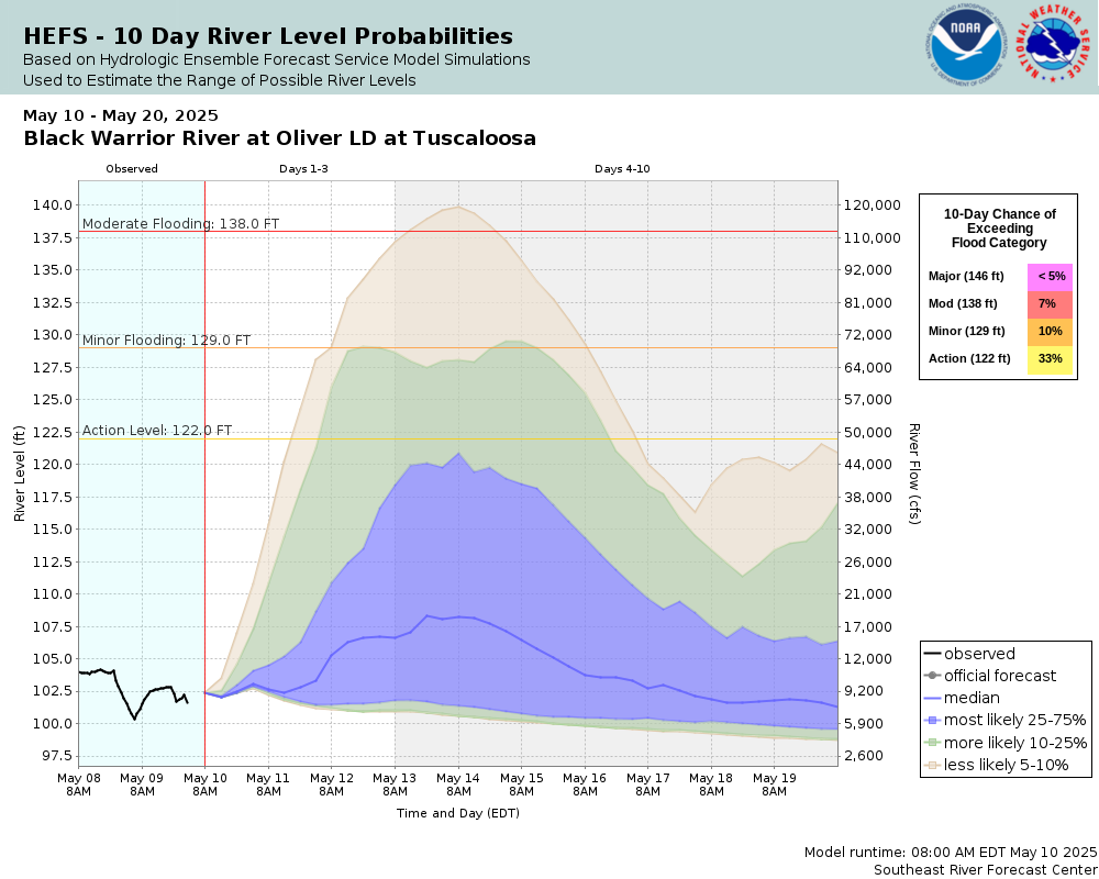
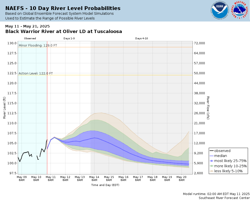
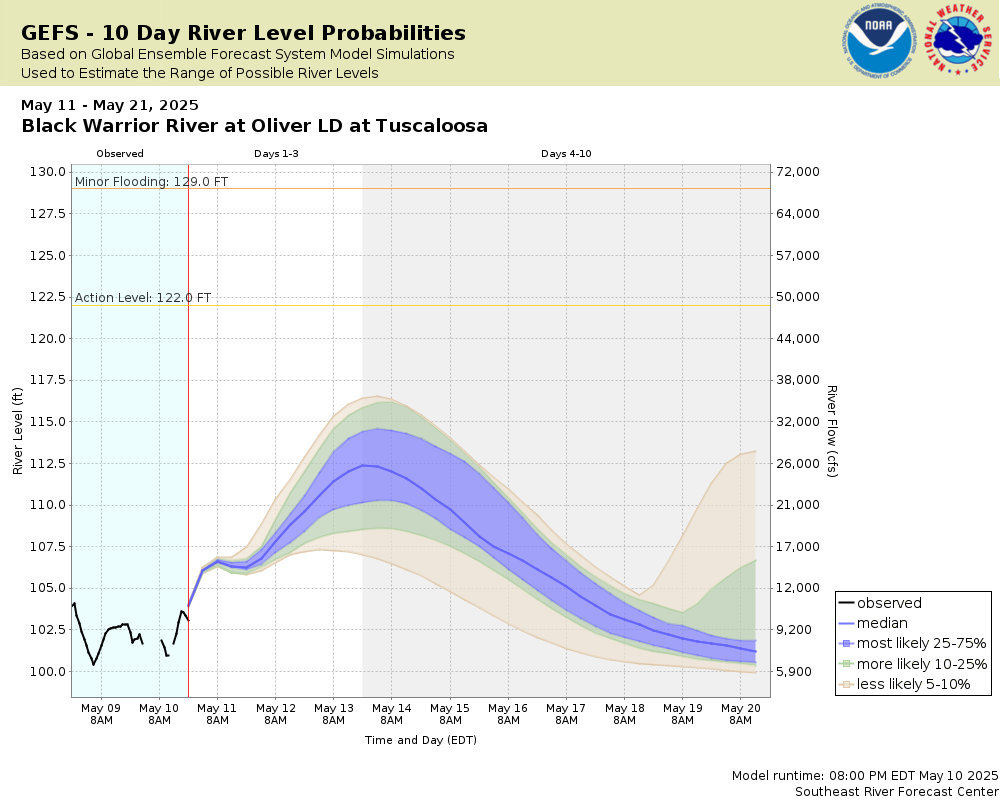
Latitude/Longitude Disclaimer: The gauge location shown in the above map is the approximate location based on the latitude/longitude coordinates provided to the NWS by the gauge owner.
Gauge Information
Flood Categories (in feet)
Major Flood Stage:
146
Moderate Flood Stage:
138
Flood Stage:
129
Action Stage:
122
Historical Crests (1) 149.00 ft on 02/22/1961 (2) 148.30 ft on 03/29/1951 (3) 148.00 ft on 04/13/1979 (4) 146.70 ft on 01/06/1949 (5) 145.80 ft on 02/11/1946 Show More Historical Crests
Low Water Records (1) 92.30 ft on 10/05/1953
Graphical representation of flood inundation for NWS flood categories are based on steady state hydraulic modeling of water surface elevations for incremented discharges. Map shows approximate inundation areas for given water surface elevations and should not be used for navigation or permitting or other legal purposes, but strictly as a planning reference tool.
Extended rating:
Rating Curve Extension - The Rating Curve Extension is calculated by using either a linear, logarithmic, or hydraulic technique to extend the rating curve above the currently established relationship between stage and flow.
Flood Impacts
153
WATER REACHES THE TOP OF THE LEVEE AT NORTHPORT. AT HIGHER STAGES FLOODING OF NORTHPORT CAN BE EXPECTED.
149
EXTENSIVE BUSINESS AND INDUSTRIAL FLOODING OCCURS ALONG JACK WARNER PARKWAY IN TUSCALOOSA.
147
WATER BEGINS TO ENTER THE TUSCALOOSA WATER WORKS PLANT. FLOODING ALONG JACK WARNER PARKWAY WORSENS. PARK AT ANDERSON LANDING FLOODS AT STAGES OF 148 FEET.
146
CONSIDERABLE FLOODING OF INDUSTRAIAL AND COMMERCIAL INTERESTS ALONG JACK WARNER PARKWAY OCCURS.
144
FLOODING OF RICE MINE ROAD IN NORTHPORT AND NORTHEAST TUSCALOOSA BEGINS.
140
FLOODING OF PORTIONS OF JACK WARNER PARKWAY CAN BE EXPECTED. SOME INDUSTRIAL PROPERTY MAY ALSO BEGIN TO FLOOD ALONG JACK WARNER PARKWAY. RESIDENTIAL FLOODING WILL COMMENCE IN AREAS SOUTHWEST OF TUSCALOOSA AT STAGES ABOVE 140 FEET.
135
NUMEROUS CAMPHOUSES AND SOME PERMANENT RESIDENCES SOUTHWEST OF TUSCALOOSA BECOME CUTOFF.
132
FLOODING OF RURAL ROADS SOUTHWEST OF TUSCALOOSA OCCURS.
129
FLOODING OF AGRICULTURAL LANDS IN AREAS SOUTHWEST OF TUSCALOOSA OCCURS.
125
FLOODING OF SOME ROADS LEADING INTO HOMES IN THE HEMPHILL BEND AREA SOUTHWEST OF TUSCALOOSA OCCURS.
122
CATTLE IN LOWLANDS BEGIN TO BE CUT OFF AND MAY NEED TO BE MOVED TO HIGHER GROUND.
The National Weather Service prepares its forecasts and other services in collaboration with agencies like the US Geological Survey, US Bureau of Reclamation, US Army Corps of Engineers, Natural Resource Conservation Service, National Park Service, ALERT Users Group, Bureau of Indian Affairs, and many state and local emergency managers across the country. For details, please click here.
Graphical representation of flood inundation for NWS flood categories are based on steady state hydraulic modeling of water surface elevations for incremented discharges. Map shows approximate inundation areas for given water surface elevations and should not be used for navigation or permitting or other legal purposes, but strictly as a planning reference tool.