Latitude/Longitude Disclaimer: The gauge location shown in the above map
is the approximate location based on the latitude/longitude coordinates
provided to the NWS by the gauge owner.
Flood Impacts & Photos
If you notice any errors in the below information, please contact our Webmaster
1436.8
Elevation of Top of Dam
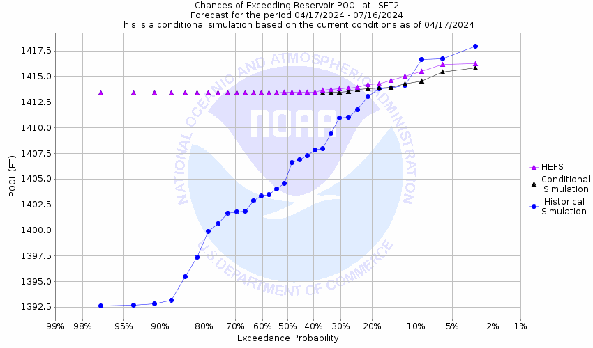
1425.8
Elevation of Emergency Spillway. Emergency Spillway is located on the right end (south) of dam. Spillway is a natural channel.
1419
Water begins to enter homes.
1418
Homes in the Vedas Camp area of the lake are threatened by water.
1417.8
About one foot above the principal spillway, homes in the Greens Camp area of the lake are threatened by water.
1416.8
Elevation of Service Spillway. Spillway is excavated channel 900 feet to left (north) of dam.
The National Weather Service prepares its forecasts and other services in collaboration with agencies like the US Geological Survey, US Bureau of Reclamation, US Army Corps of Engineers, Natural Resource Conservation Service, National Park Service, ALERT Users Group, Bureau of Indian Affairs, and many state and local emergency managers across the country. For details, please click here.
NWS Information
National Weather Service
San Angelo Weather Forecast Office
7654 Knickerbocker Road
San Angelo, TX 76904
(325) 944-9445 Ask Questions/Webmaster
Page last modified: 30-Oct-2020 4:09 PM