Skip Navigation Link weather.gov  
NOAA logo - Click to go to the NOAA homepage National Weather Service NWS logo - Click to go to the NWS homepage
Advanced Hydrologic Prediction Service
Image background of Navigation bar Left
Navigation Bar End Cap


This probabilistic forecast is issued by the West Gulf River Forecast Center.
tab left off Hydrograph tab right off tab left off River at a Glance tab right off tab left off Download tab right off tab left on tab right on
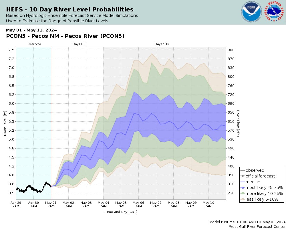
Experimental Short Range Forecast Uncertainty (AHPS) - External Links: Product Description Document | Customer Survey
About this graph
Graphical forecasts are not available for the Pecos River above Pecos. During times of high water, forecast crest information can be found in the text products.
Return to Area Map

Downstream Gauge Downstream Locations
Zoom Level:16
Flood Categories (in feet)
Major Flood Stage: 7.5
Moderate Flood Stage: 6
Flood Stage: 5
Action Stage: 4.5
Low Stage (in feet): -9999

Historic Crests
(1) 6.20 ft on 09/21/1929
(2) 5.12 ft on 05/21/1991
(3) 4.79 ft on 06/07/1997
(4) 4.73 ft on 06/08/1979
(5) 4.71 ft on 06/18/1995
Show More Historic Crests

(P): Preliminary values subject to further review.

Recent Crests
(1) 4.09 ft on 05/09/2009
(2) 4.19 ft on 05/22/2005
(3) 3.75 ft on 05/24/1999
(4) 3.77 ft on 07/14/1998
(5) 4.79 ft on 06/07/1997
Show More Recent Crests

(P): Preliminary values subject to further review.

Low Water Records
Currently none available.
KML Image
Gauge LocationGauge Map Marker
Disclaimer
Latitude/Longitude Disclaimer: The gauge location shown in the above map is the approximate location based on the latitude/longitude coordinates provided to the NWS by the gauge owner.
Flood Impacts & Photos Collapse
If you notice any errors in the below information, please contact our Webmaster
7.5 Widespread flooding is in progress or is imminent along the Upper Pecos River, mainly above the town of Pecos. Portions of state route 63 north of the fish hatchery are under water. Private bridges over the river may be washed away and homes along the river could experience significant flood damage.
6 Water threatens homes nearest the river along the Upper Pecos. The Pecos river has not been this high since 1929. Portions of state road 63 above the fish hatchery may become impassable due to water over the road. Private bridges on the Upper Pecos above the town of Pecos may become impassable or be washed away.
5 Fast flowing water may erode banks and approach homes near the river. Private bridges could drive localized flooding as debris accumulates along the upstream sides. Further rises may make bridges unsafe to cross and isolate residents.

Other Real-time and/or Archive Data Sources:

Collaborative Agencies Collapse
The National Weather Service prepares its forecasts and other services in collaboration with agencies like the US Geological Survey, US Bureau of Reclamation, US Army Corps of Engineers, Natural Resource Conservation Service, National Park Service, ALERT Users Group, Bureau of Indian Affairs, and many state and local emergency managers across the country. For details, please click here.
NWS Information
National Weather Service
Albuquerque Weather Forecast Office
2341 Clark Carr Loop SE
Albuquerque, NM 87106
(505) 243-0702
Ask Questions/Webmaster
Page last modified: 2-Nov-2020 7:28 PM
Disclaimer
Credits
Glossary
Privacy Policy
About Us
Career Opportunities