Skip Navigation Link weather.gov  
NOAA logo - Click to go to the NOAA homepage National Weather Service NWS logo - Click to go to the NWS homepage
Advanced Hydrologic Prediction Service
Image background of Navigation bar Left
Navigation Bar End Cap


This probabilistic forecast is issued by the Middle Atlantic River Forecast Center.
tab left off Hydrograph tab right off tab left off River at a Glance tab right off tab left off Download tab right off tab left off Inundation
Mapping
tab right off tab left on tab right on
About this graph
Forecasts for the Chemung River at Elmira are issued routinely year-round.
Return to Area Map

Upstream Gauge - at Corning Upstream Gauge Downstream Gauge Downstream Gauge - at Chemung
Zoom Level:16
Flood Categories (in feet)
Major Flood Stage: 19
Moderate Flood Stage: 15
Flood Stage: 12
Action Stage: 10
Low Stage (in feet): -9999

Historic Crests
(1) 25.20 ft on 06/23/1972
(2) 21.20 ft on 05/28/1946
(3) 19.70 ft on 09/26/1975
(4) 18.51 ft on 01/19/1996
(5) 18.30 ft on 07/09/1935
Show More Historic Crests

(P): Preliminary values subject to further review.

Recent Crests
(1) 13.40 ft on 10/30/2021
(2) 12.49 ft on 08/19/2021
(3) 12.16 ft on 05/16/2014
(4) 12.19 ft on 09/03/2006
(5) 12.47 ft on 11/30/2005
Show More Recent Crests

(P): Preliminary values subject to further review.

Low Water Records
(1) 0.79 ft on 10/16/2016
KML Image
Gauge LocationGauge Map Marker
Disclaimer
Latitude/Longitude Disclaimer: The gauge location shown in the above map is the approximate location based on the latitude/longitude coordinates provided to the NWS by the gauge owner.
Flood Impacts & Photos Collapse
If you notice any errors in the below information, please contact our Webmaster
25.2 Devastating flood damage occurs throughout the City of Elmira and surrounding areas. Public utilities, transportation, and communications are severely disrupted. This is the record flood from June 1972.
25 Water overtops the north bank of the levee system resulting in widespread flooding of downtown Elmira.
23 The Carriage Estates neighborhood and Farm Lane in Ashland flood. Flooding extends to 3rd Street in Wellsburg. The City of Elmira is protected by levees to 25 feet.
20 Neighborhoods south of Water Street in West Elmira experience extensive flooding. Properties along West Hudson Street at Morrowfield, Bonaview, and Homewood Avenues in the Town of Southport flood. The City of Elmira is protected by levees to 25 feet.
19 Most of Big Flats is inundated. Streets between York Avenue and Morningside Drive in West Elmira begin flooding. Homes at the lower end of Morningside and Country Club Drive are flooded to the first floor. Routes 225 and 352 are closed at Fitch's Bridge. Flooding worsens along Lower Maple Avenue from Southport to Wellsburg. The City of Elmira is protected by levees to 25 feet.
15 The Hamlet of Big Flats begins to flood. Water may also affect streets nearest the river from Golden Glow Heights through West Elmira. Flooding extends into the Town of Soutport affecting neighborhoods along Maple Avenue. Front Street in Wellsburg floods. The City of Elmira is protected by levees to 25 feet.
12 Minor flooding develops outside the area of levees and flood protection. Portions of Lower Maple Avenue (Route 427) in the Town of Ashland may be closed. The Lowman Crossover floods. Route 352 in Big Flats floods. The City of Elmira is protected by levees to 25 feet.
Photos
(1) looking upstream
(2) view of gagehouse
(3) looking downstream

Other Real-time and/or Archive Data Sources:

Additional Information Collapse
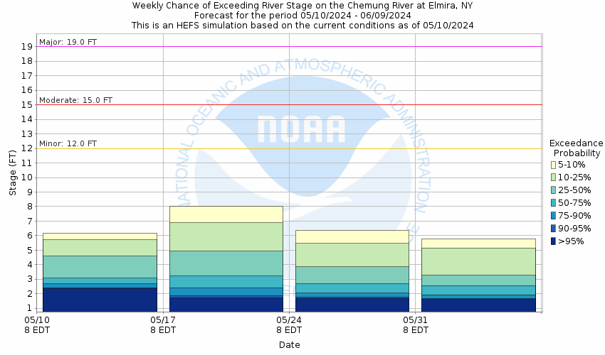
Potential River Levels - Used to
Potential River Levels
Used to Estimate the Chance of Flooding and the Range of Possible River Levels
10 Day (HEFS) 7 Day (NAEFS) 7 Day (GEFS)
HEFS Ensemble NAEFS Ensemble GEFS Ensemble

Note: Use the official hydrograph at the top of this web page for river levels within the next 72 hours.

Click individual graphics to enlarge.

Collaborative Agencies Collapse
The National Weather Service prepares its forecasts and other services in collaboration with agencies like the US Geological Survey, US Bureau of Reclamation, US Army Corps of Engineers, Natural Resource Conservation Service, National Park Service, ALERT Users Group, Bureau of Indian Affairs, and many state and local emergency managers across the country. For details, please click here.
NWS Information
National Weather Service
Binghamton Weather Forecast Office
32 Dawes Drive
Johnson City, NY 13790
(607) 729-1597
Ask Questions/Webmaster
Page last modified: 2-Nov-2020 7:30 PM
Disclaimer
Credits
Glossary
Privacy Policy
About Us
Career Opportunities