Skip Navigation Link weather.gov  
NOAA logo - Click to go to the NOAA homepage National Weather Service NWS logo - Click to go to the NWS homepage
Advanced Hydrologic Prediction Service
Image background of Navigation bar Left
Navigation Bar End Cap


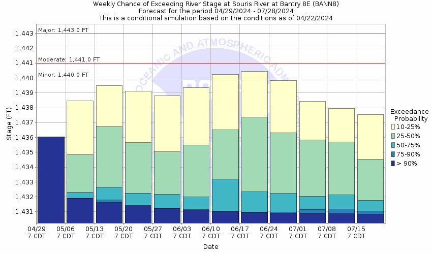
This probabilistic forecast is issued by the North Central River Forecast Center.
tab left off Hydrograph tab right off tab left off River at a Glance tab right off tab left off Download tab right off tab left on tab right on
About this graph
Forecasts for the Souris River near Bantry are issued as needed during times of high water, but are not routinely available.
Return to Area Map

Upstream Gauge - near Towner Upstream Gauge Downstream Gauge Downstream Gauge - near Westhope
Zoom Level:15
Flood Categories (in feet)
Major Flood Stage: 1443
Moderate Flood Stage: 1441
Flood Stage: 1440
Action Stage: 1439
Low Stage (in feet): -9999

Historic Crests
(1) 1,445.66 ft on 06/28/2011
(2) 1,444.48 ft on 06/23/2013 (P)
(3) 1,443.35 ft on 04/23/1976
(4) 1,443.08 ft on 06/11/2013
(5) 1,442.89 ft on 04/20/2009
Show More Historic Crests

(P): Preliminary values subject to further review.

Recent Crests
(1) 4.40 ft on 06/13/2021
(2) 9.81 ft on 04/04/2019
(3) 9.09 ft on 04/28/2018
(4) 1,441.55 ft on 04/09/2017
(5) 1,435.79 ft on 05/13/2016
Show More Recent Crests

(P): Preliminary values subject to further review.

Low Water Records
(1) 0.70 ft on 01/01/1980
KML Image
Gauge LocationGauge Map Marker
Disclaimer
Latitude/Longitude Disclaimer: The gauge location shown in the above map is the approximate location based on the latitude/longitude coordinates provided to the NWS by the gauge owner.
Flood Impacts & Photos Collapse
If you notice any errors in the below information, please contact our Webmaster
1440.2 Water begins crossing the road several hundred feet to the left of the bridge. No towns or major roads are flooded.
1439.7 Flood waters affect farmland or wooded areas in refuge. Due to relative flatness of the area within reach of the gage a rather large area becomes flooded. Damage is to crops and farm buildings.
1437.8 River flow no longer confined to one channel. Flow begins in channel 2 miles west and through various culverts that may be blocked in winter months.
1435.8 Right bank with heavy trees and brush subject to overflow.
Photos
(1) Souris River near Bantry-Downstream View
(2) Upstream view-with gage house.

Other Real-time and/or Archive Data Sources:

Additional Information Collapse
How low could the river get?
Collaborative Agencies Collapse
The National Weather Service prepares its forecasts and other services in collaboration with agencies like the US Geological Survey, US Bureau of Reclamation, US Army Corps of Engineers, Natural Resource Conservation Service, National Park Service, ALERT Users Group, Bureau of Indian Affairs, and many state and local emergency managers across the country. For details, please click here.
NWS Information
National Weather Service
Bismarck Weather Forecast Office
2301 University Drive, Building 27
Bismarck, ND 58502-1016
(701) 250-4224
Ask Questions/Webmaster
Page last modified: 2-Nov-2020 7:29 PM
Disclaimer
Credits
Glossary
Privacy Policy
About Us
Career Opportunities