Historic Crests
(1) 14.97 ft on 04/01/2010
(2) 14.51 ft on 03/17/2010
(3) 14.48 ft on 03/20/1968
(4) 13.02 ft on 08/21/1955
(5) 12.54 ft on 04/08/1987 Show More Historic Crests
(P): Preliminary values subject to further review.
Recent Crests
(1) 10.08 ft on 03/30/2024
(2) 8.00 ft on 03/27/2024
(3) 9.39 ft on 03/25/2024
(4) 9.03 ft on 03/11/2024
(5) 8.23 ft on 03/09/2024 Show More Recent Crests
(P): Preliminary values subject to further review.
Latitude/Longitude Disclaimer: The gauge location shown in the above map
is the approximate location based on the latitude/longitude coordinates
provided to the NWS by the gauge owner.
Flood Impacts & Photos
If you notice any errors in the below information, please contact our Webmaster
15
This is near the flood of record. Floodwaters force prolonged closures of Route 44 in Taunton. Floodwaters reach onto West Water and Ingell Streets in Taunton. Along the Bridgewater/Middleboro town line, lowest lying homes along Vernon and Green Streets are impacted. The river inundates Titicut, Plymouth and Summer Streets and Woloski Park, and floodwaters back up behind the railroad bridge. In Halifax, Cherry Street floods. Follow the advice of local officials, and evacuate if asked to do so.
14
Significant flooding will affect interests along the river. Prolonged closures occur along Route 44 in Taunton. Floodwaters reach onto West Water and Ingell Streets in Taunton, and Cherry Street in Halifax. Along the Bridgewater/Middleboro town line, lowest lying homes are impacted along Vernon and Green Streets. Titicut, Plymouth and Summer Streets and Woloski Park are inundated. Floodwaters back up behind the railroad bridge. Follow the advice of local officials and evacuate if asked to do so.
13
Flooding is likely in low lying areas along the river in Bridgewater, Middleboro, Raynham and Taunton. Flooding occurs along Route 44 in Taunton. Floodwaters spread into lowest lying businesses on Route 44 near the Taunton and Raynham line. The river encroaches on lowest lying homes on Vernon and Green Streets at the Middleboro/Bridgewater town line, and Summer Street is inundated. Woloski Park is flooded for an extended period of time. Heed the advice of local officials, and evacuate if asked to do so.
12
Flooding affects low lying areas in Bridgewater, Middleboro, and Taunton. Floodwaters encroach on portions of Route 44 in Taunton. Backwater flooding occurs on low lying properties near the intersections of Dean and Arlington streets in Taunton. Woloski Park in Middleboro is isolated for a long period of time due to flooding. Heed the advice of local officials, and evacuate if asked to do so.
11
Minor lowland and backyard flooding is likely along reaches of the river along Bridgewater and Middleboro. Backwater flooding from the Taunton River will cause prolonged flooding of lower Purchade Brook in Middleboro. This will cause Woloski Park to become impassable by vehicles for days. Beware of the dangers of crossing flooded roadways- the water may be deeper than you think. Floodwaters have the ability to damage roadways. Heed the advice of local officials, and evacuate if asked to do so.
9
Backwater flooding from the Taunton River will cause flooding of lower Purchade Brook in Middleboro. This will cause Woloski Park to become impassable by most vehicles for an extended period of time. Beware of the dangers of crossing flooded roadways. The water may be deeper than you think. Floodwaters have the ability to damage roadways. Heed the advice of local officials, and evacuate if asked to do so.
8
Backwater flooding from the Taunton River will cause flooding of lower Purchade Brook in Middleboro. This will cause Woloski Park to become impassable by most vehicles. Beware of the dangers of crossing flooded roadways.
7.5
Lower Purchade Brook in Middleboro often floods when the Taunton River at Bridgewater reaches this level. This can result in blockage or closure of the Woloski Park accessway.
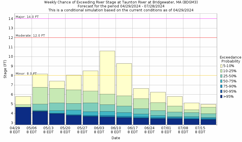
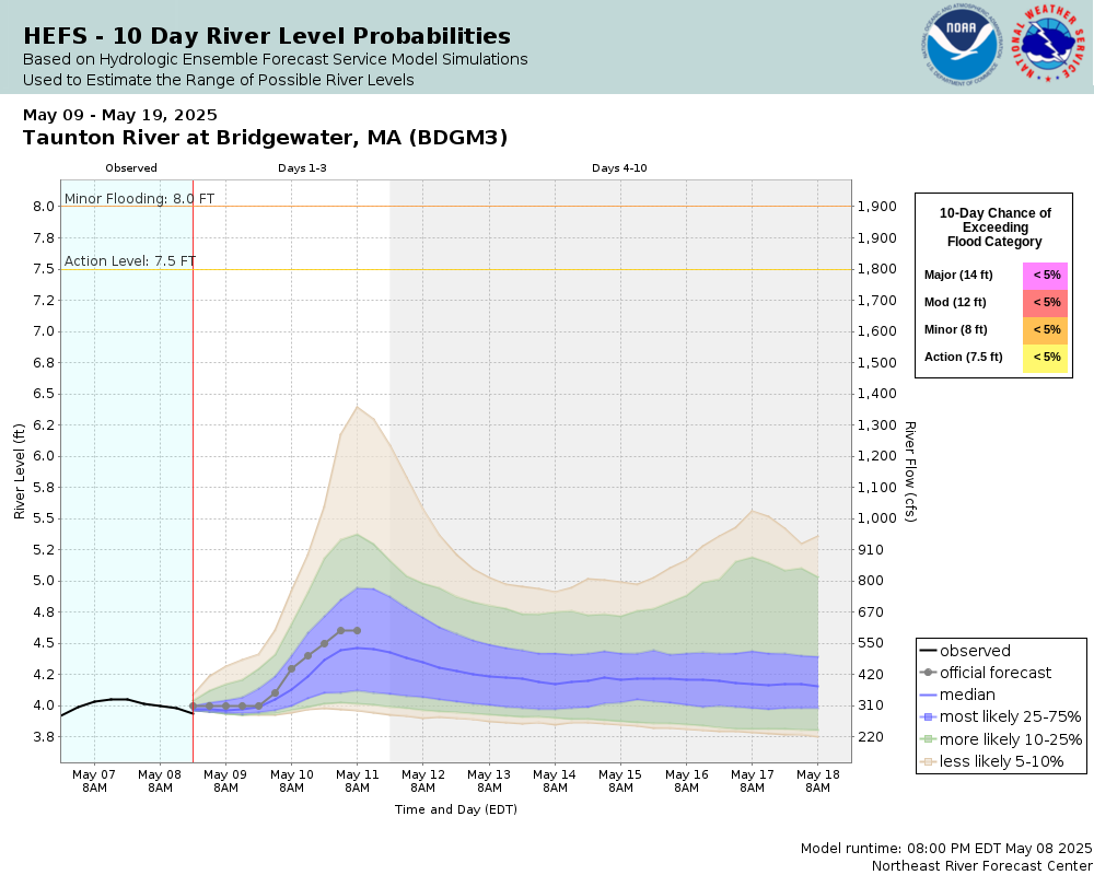
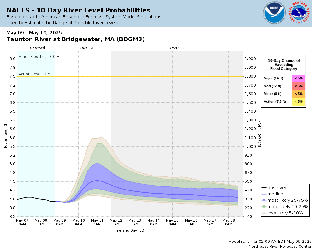
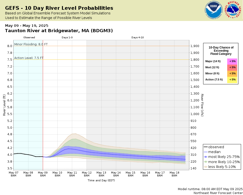
Potential River Levels Used to Estimate the Chance of Flooding and
the Range of Possible River Levels
10 Day (HEFS)
7 Day (NAEFS)
7 Day (GEFS)
Note: Use the official hydrograph at the top of this web page
for river levels within the next 72 Hours.
Click individual graphics to
enlarge.
Collaborative Agencies
The National Weather Service prepares its forecasts and other services in collaboration with agencies like the US Geological Survey, US Bureau of Reclamation, US Army Corps of Engineers, Natural Resource Conservation Service, National Park Service, ALERT Users Group, Bureau of Indian Affairs, and many state and local emergency managers across the country. For details, please click here.
NWS Information
National Weather Service
Boston / Norton Weather Forecast Office
46 Commerce Way
Norton, MA 02766
(508) 622-3250 Ask Questions/Webmaster
Page last modified: 2-Nov-2020 7:30 PM