Skip Navigation Link weather.gov  
NOAA logo - Click to go to the NOAA homepage National Weather Service NWS logo - Click to go to the NWS homepage
Advanced Hydrologic Prediction Service
Image background of Navigation bar Left
Navigation Bar End Cap


This probabilistic forecast is issued by the Northeast River Forecast Center.
tab left off Hydrograph tab right off tab left off River at a Glance tab right off tab left off Download tab right off tab left on tab right on
About this graph
Forecasts for the Westfield River at Westfield are issued routinely year-round.

Vertical datum height surveyed by the USGS

Return to Area Map

Zoom Level:16
Flood Categories (in feet)
Major Flood Stage: 20
Moderate Flood Stage: 16
Flood Stage: 13
Action Stage: 12
Low Stage (in feet): -9999

Historic Crests
(1) 34.20 ft on 08/19/1955
(2) 27.20 ft on 03/18/1936
(3) 25.41 ft on 11/04/1928
(4) 22.66 ft on 06/16/1933
(5) 22.13 ft on 04/07/1924
Show More Historic Crests

(P): Preliminary values subject to further review.

Recent Crests
(1) 15.39 ft on 12/18/2023
(2) 13.72 ft on 09/02/2021
(3) 13.88 ft on 07/19/2021
(4) 12.93 ft on 11/03/2018
(5) 13.59 ft on 01/13/2018
Show More Recent Crests

(P): Preliminary values subject to further review.

Low Water Records
Currently none available.
KML Image
Gauge LocationGauge Map Marker
Disclaimer
Latitude/Longitude Disclaimer: The gauge location shown in the above map is the approximate location based on the latitude/longitude coordinates provided to the NWS by the gauge owner.
Flood Impacts & Photos Collapse
If you notice any errors in the below information, please contact our Webmaster
28 Top of river gage instrument shelf. Gage can not report higher than this level. This is a major life threatening flood. Heed the advice of local officials and evacuate if asked to do so.
24 This is a major life threatening flood event from Montgomery and Russel through West Springfield and Agawam. Homes and businesses along the river will flood. Portions of Route 20 will be closed. Some residential areas and shopping centers will require evacuations. Backwater flooding on tributary streams is also anticipated. Follow the directions of emergency management officials and act quickly if you are told to evacuate.
22 This is a major life threatening flood event from Montgomery and Russel through West Springfield and Agawam. Low lying homes and businesses along the river will flood. Portions of Route 20 will be closed. Some residential areas and shopping centers will require evacuations. Backwater flooding on tributary streams is also anticiapted. Follow the directions of emergency management officials and act quickly if you are told to evacuate.
20 This is a major life threatening flood event. Significant flooding is likely along the Westfield River from Montgomery and Russel through West Springfield and Agawam. Portions of Route 20 will be closed. Shopping centers and some residential areas along the river will require evacuations. Follow the directions of your local police and fire officals to avoid flooded areas.
18 Significant flooding is likely along the Westfield River and many of its small tributaries. Portions of Route 20 will be closed and several shopping centers along the river may require evacuations. Follow the directions of your local police and fire officals to avoid flooded areas.
17 Interests along the Westfield River and its smaller tributaries including Powdermill Brook and the Little River should take action to protect property. Some small scale evacuations may be required as flood waters inundate areas along Route 20 from West Springfield upstream through Tecowa country club.
16 Interests along the Westfield River and its smaller tributaries including Powdermill Brook and the Little River should take action to protect property. Some small scale evacuations may be required as flood waters inundate areas along Route 20.
15 Interests along the Westfield River and its smaller tributaries including Powdermill Brook and the Little River should take action to protect property. Road closures are expected including portions of Route 20 through Westfield.
14.5 Road closures may be required along Route 20 and Union Avenue. Flooding is expected to spread into the Westgate Shopping Center parking area. Flooding will also develop where the Little River and Powdermill Brook join the Westfield. Other smaller tributaries will experience flooding.
14 Flooding of low lying sections along the river through Westfield is expected. The Westfield River will also backup the Little River and Powdermill Brook with flooding expected along these smaller tributaries. Road closures may be required along Route 20 and Union Avenue. Flooding is also expected in the Westgate Shopping Center parking area.
13.5 Businesses in low lying sections along the river through Westfield should take action to protect materials that are in flood prone areas at stages around 13.50 feet. Localized flooding in the Frogs Hole area is expected.
13 Flooding of low lying sections along the river through Westfield is expected. Business interests should take action to protect materials that are in flood prone areas. Flooding is also expected across a portion of Union Avenue in the Frogs Hole area.

Other Real-time and/or Archive Data Sources:

Additional Information Collapse
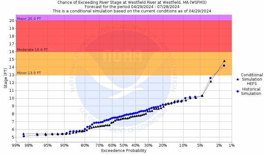
Potential River Levels - Used to
Potential River Levels
Used to Estimate the Chance of Flooding and the Range of Possible River Levels
10 Day (HEFS) 7 Day (NAEFS) 7 Day (GEFS)
HEFS Ensemble NAEFS Ensemble GEFS Ensemble

Note: Use the official hydrograph at the top of this web page for river levels within the next 72 hours.

Click individual graphics to enlarge.

Collaborative Agencies Collapse
The National Weather Service prepares its forecasts and other services in collaboration with agencies like the US Geological Survey, US Bureau of Reclamation, US Army Corps of Engineers, Natural Resource Conservation Service, National Park Service, ALERT Users Group, Bureau of Indian Affairs, and many state and local emergency managers across the country. For details, please click here.
NWS Information
National Weather Service
Boston / Norton Weather Forecast Office
46 Commerce Way
Norton, MA 02766
(508) 622-3250
Ask Questions/Webmaster
Page last modified: 2-Nov-2020 7:30 PM
Disclaimer
Credits
Glossary
Privacy Policy
About Us
Career Opportunities