Historic Crests
(1) 17.21 ft on 08/29/2011
(2) 16.36 ft on 07/11/2023 (P)
(3) 13.45 ft on 09/22/1938
(4) 13.25 ft on 06/30/1973
(5) 13.01 ft on 04/06/1987 Show More Historic Crests
(P): Preliminary values subject to further review.
Recent Crests
(1) 9.69 ft on 03/08/2024 (P)
(2) 11.10 ft on 12/19/2023 (P)
(3) 16.36 ft on 07/11/2023 (P)
(4) 9.71 ft on 12/26/2020
(5) 12.34 ft on 04/16/2019 Show More Recent Crests
(P): Preliminary values subject to further review.
Low Water Records (1) 0.99 ft on 09/07/2016 (2) 1.08 ft on 09/29/2020 (3) 1.14 ft on 09/06/2015
Latitude/Longitude Disclaimer: The gauge location shown in the above map
is the approximate location based on the latitude/longitude coordinates
provided to the NWS by the gauge owner.
Flood Impacts & Photos
If you notice any errors in the below information, please contact our Webmaster
17
Severe to devastating flooding of low lying areas along the Otter Creek will occur in Rutland County, from Rutland downstream through Brandon, Proctor and Pittsford. This includes portions of Routes 3, 4 and 7. Many homes will be impacted with evacuations likely needed in some areas. Several power, pump and hydro stations will also flood. Levels will be similar to those experienced during Tropical Storm Irene during August 2011.
16
Widespread, severe flooding of low lying areas along the Otter Creek in Rutland County from Rutland downstream through Brandon, Proctor and Pittsford will occur. In Rutland, this includes, but is not limited to, Ripley Rd., Dorr Dr., Clement Rd., Meadow St., and low lying areas on Route 3. Flooding may also affect the power station on Old Falls Rd. and the buildings at the College of St. Joseph. Levels will be similar to those seen in August 2011 from Tropical Storm Irene and during the floods of July 2023.
15
Widespread flooding of many low lying roads along the Otter Creek in Rutland County will occur. In Rutland, this includes, but is not limited to, Meadow Street, Clement Road, Park Street, Dorr Drive the Glen Hydro Station on Route 7, and near the juncture of Route 4 and West Proctor Road. Route 73 west of Brandon will be flooded. Downstream in Pittsford and Proctor, numerous low lying roads will be inundated, including, but not limited to, Elm Street, Willow Street and Depot Hill Road.
12
In Rutland, homes and businesses will be flooded along Dorr Drive and Park Street, and near the junction of Route 4 and West Proctor Road. High water will also impact Meadow Street, Clement Road and the Glen Hydro Station on Route 7. There will be widespread inundation of low lying roads from Clarendon downstream to Proctor and Pittsford, and Route 73 west of Brandon will flood. Other portions of Route 7 in Rutland County may be threatened by tributaries to Otter Creek.
11
Water will come near homes and businesses in Rutland along Otter Creek on Dorr Dr., Park St., Meadow St., Clement Rd., and along the confluence of Otter Creek and the Clarendon River at West Proctor Rd. and Rte 4. Low lying roads in Clarendon and Wallingford will flood. Downstream in Proctor and Pittsford, numerous roads will be inundated, including Elm St., Willow St. and Depot Hill Road. Route 73 west of Brandon will flood.
10
In Rutland, flooding will occur on low lying roads including Dorr Drive, Park Street and Clement Road. High water will also approach Meadow Street and the adjacent recreation fields will flood. Alfrecha Road in Clarendon will flood. Water will approach homes on West Proctor Road near Route 4 in Rutland. Downstream in Proctor and Pittsford, numerous roads will flood, along with Route 73 west of Brandon.
9
In Clarendon, low lying portions of South Creek Rd. will flood between Walker Mountain Rd. and Wallingford, and water will approach Alfrecha Rd. In Pittsford, Elm St. and Depot Hill Rd. will begin to flood. Field flooding will occur along Dorr Dr. in Rutland, along with lowland flooding upstream to Wallingford and downstream to Pittsford.
8
Low lying portions of South Creek Road will flood in Clarendon between Walker Mountain Road and Wallingford. In Pittsford, Elm Street and Depot Road will be under water. Field flooding will occur along Dorr Drive in Rutland, along with lowland flooding upstream to Wallingford and downstream to Pittsford.
7
There will be field flooding along Otter Creek from Clarendon downstream to Pittsford.
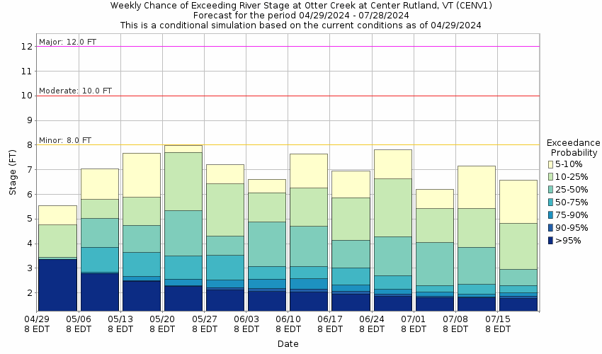
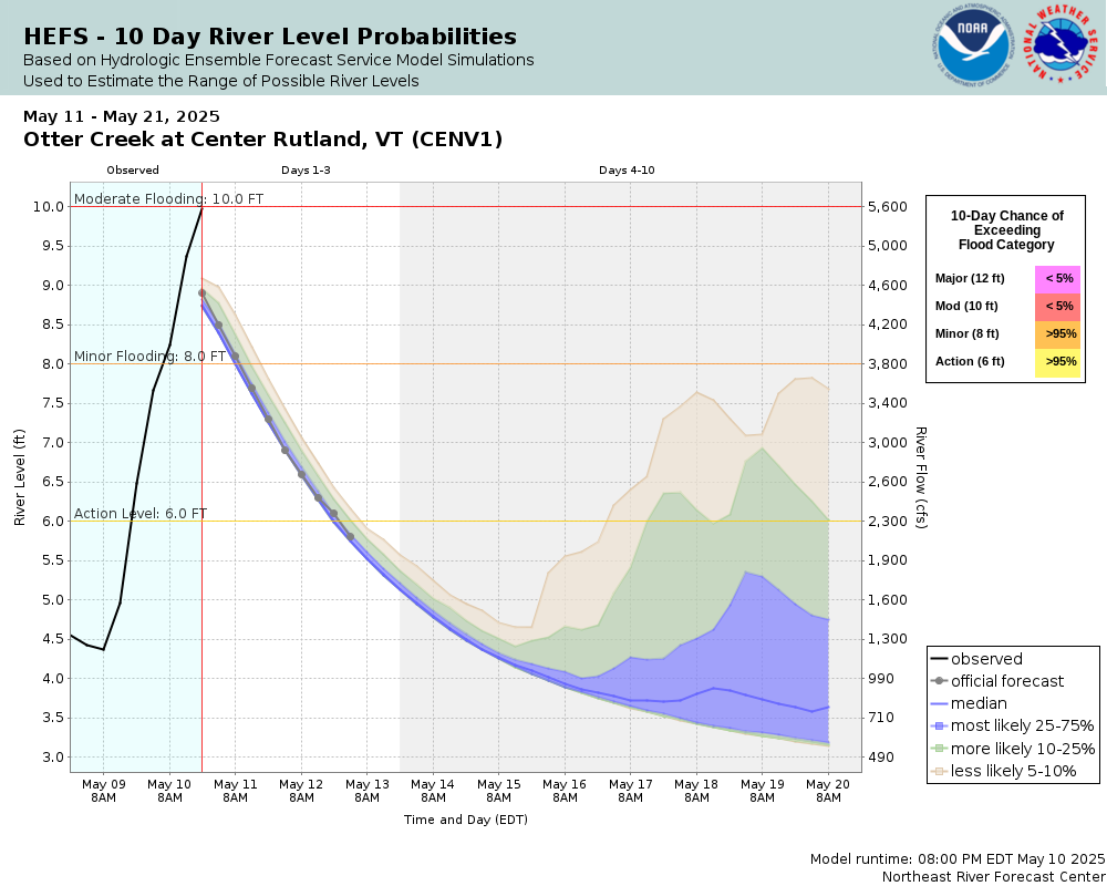
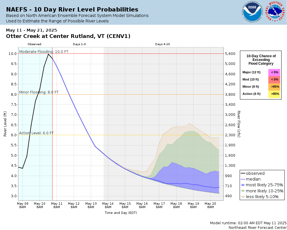
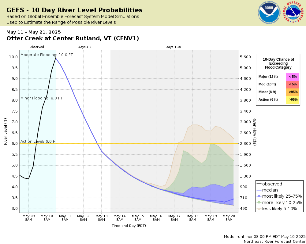
Potential River Levels Used to Estimate the Chance of Flooding and
the Range of Possible River Levels
10 Day (HEFS)
7 Day (NAEFS)
7 Day (GEFS)
Note: Use the official hydrograph at the top of this web page
for river levels within the next 72 hours.
Click individual graphics to
enlarge.
Collaborative Agencies
The National Weather Service prepares its forecasts and other services in collaboration with agencies like the US Geological Survey, US Bureau of Reclamation, US Army Corps of Engineers, Natural Resource Conservation Service, National Park Service, ALERT Users Group, Bureau of Indian Affairs, and many state and local emergency managers across the country. For details, please click here.
NWS Information
National Weather Service
Burlington Weather Forecast Office
1200 Airport Drive
South Burlington, VT 05403
(802) 862-2475 Ask Questions/Webmaster
Page last modified: 2-Nov-2020 7:30 PM