Skip Navigation Link weather.gov  
NOAA logo - Click to go to the NOAA homepage National Weather Service NWS logo - Click to go to the NWS homepage
Advanced Hydrologic Prediction Service
Image background of Navigation bar Left
Navigation Bar End Cap


This probabilistic forecast is issued by the Middle Atlantic River Forecast Center.
tab left off Hydrograph tab right off tab left off River at a Glance tab right off tab left off Download tab right off tab left off Inundation
Mapping
tab right off tab left on tab right on
About this graph
Forecasts for the Susquehanna River at Bloomsburg are issued routinely year-round.
Return to Area Map

Upstream Gauge - at Wilkes Barre Upstream Gauge Downstream Gauge Downstream Gauge - at Danville
Zoom Level:12
Flood Categories (in feet)
Major Flood Stage: 28
Moderate Flood Stage: 22
Flood Stage: 19
Action Stage: 16
Low Stage (in feet): 0

Historic Crests
(1) 32.75 ft on 09/09/2011
(2) 32.70 ft on 03/09/1904
(3) 31.20 ft on 06/25/1972
(4) 28.64 ft on 06/28/2006
(5) 28.20 ft on 03/18/1865
Show More Historic Crests

(P): Preliminary values subject to further review.

Recent Crests
(1) 20.39 ft on 12/27/2020 (P)
(2) 22.74 ft on 08/15/2018
(3) 32.75 ft on 09/09/2011
(4) 22.57 ft on 03/12/2011
(5) 28.64 ft on 06/28/2006
Show More Recent Crests

(P): Preliminary values subject to further review.

Low Water Records
Currently none available.
KML Image
Gauge LocationGauge Map Marker
Disclaimer
Latitude/Longitude Disclaimer: The gauge location shown in the above map is the approximate location based on the latitude/longitude coordinates provided to the NWS by the gauge owner.
Flood Impacts & Photos Collapse
If you notice any errors in the below information, please contact our Webmaster
39.5 Flood waters begin to reach the Rupert Drive Bridge in Catawissa.
36.5 FEMA 0.2% Annual Chance Flood Level (500-year flood).
32.8 Flood of record from Tropical Storm Lee in 2011.
32.3 Flood of record from Hurricane Agnes in 1972.
32 Bloomsburg high school is affected by flood waters.
30 Most areas south of 10th Street and west of Railroad Street are affected by high water. Flood waters inundate more than 25 percent of Bloomsburg.
29.5 FEMA 1% Annual Chance Flood Level (100-year flood).
28 A large part of Bloomsburg south of 10th Street and west of Railroad Street is affected by high water.
26 Much of the runway at the airport is inundated. High water begins to affect the sewage treatment plant and the race track at the fairgrounds.
24 Much of the fairgrounds, as well as adjacent areas, are affected by high water. High water also begins to affect the runway at the airport.
22.5 FEMA 10% Annual Chance Flood Level (10-year flood).
22 A number of homes located between the fairgrounds and the river are affected by high water. Several buildings at the airport are also affected.
20 High water affects the fairgrounds and the surrounding area.
19 High water affects homes along River Road.
Photos
(1) looking upstream
(2) view of the gagehouse
(3) looking downstream

Other Real-time and/or Archive Data Sources:

Additional Information Collapse
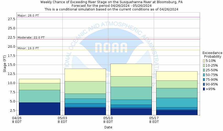
Potential River Levels - Used to
Potential River Levels
Used to Estimate the Chance of Flooding and the Range of Possible River Levels
10 Day (HEFS) 7 Day (NAEFS) 7 Day (GEFS)
HEFS Ensemble NAEFS Ensemble GEFS Ensemble

Note: Use the official hydrograph at the top of this web page for river levels within the next 72 hours.

Click individual graphics to enlarge.

Collaborative Agencies Collapse
The National Weather Service prepares its forecasts and other services in collaboration with agencies like the US Geological Survey, US Bureau of Reclamation, US Army Corps of Engineers, Natural Resource Conservation Service, National Park Service, ALERT Users Group, Bureau of Indian Affairs, and many state and local emergency managers across the country. For details, please click here.
NWS Information
National Weather Service
State College Weather Forecast Office
328 Innovation Boulevard, Suite 330
State College, PA 16803
(814) 954-6400
Ask Questions/Webmaster
Page last modified: 2-Nov-2020 7:30 PM
Disclaimer
Credits
Glossary
Privacy Policy
About Us
Career Opportunities