Latitude/Longitude Disclaimer: The gauge location shown in the above map
is the approximate location based on the latitude/longitude coordinates
provided to the NWS by the gauge owner.
Flood Impacts & Photos
If you notice any errors in the below information, please contact our Webmaster
16
Water reaches the bottom of the bridge at Road 755.
13
There will be significant flooding of rural areas near the river.
12
There will be widespread flooding of low land areas along the river including the Blue Heron Campground.
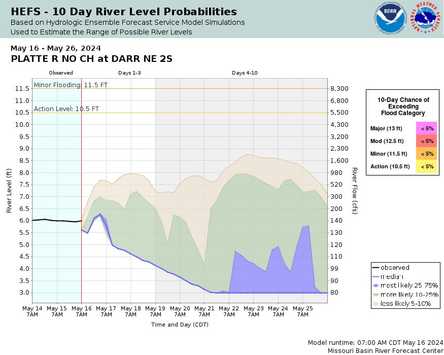
11.5
Water will begin to enter the Blue Heron campground upstream and south of Gothenburg.
The National Weather Service prepares its forecasts and other services in collaboration with agencies like the US Geological Survey, US Bureau of Reclamation, US Army Corps of Engineers, Natural Resource Conservation Service, National Park Service, ALERT Users Group, Bureau of Indian Affairs, and many state and local emergency managers across the country. For details, please click here.
NWS Information
National Weather Service
Hastings Weather Forecast Office
6365 Osborne Drive West
Hastings, NE 68901
(402) 462-2127 Ask Questions/Webmaster
Page last modified: 2-Nov-2020 7:29 PM


