Skip Navigation Link weather.gov  
NOAA logo - Click to go to the NOAA homepage National Weather Service NWS logo - Click to go to the NWS homepage
Advanced Hydrologic Prediction Service
Image background of Navigation bar Left
Navigation Bar End Cap


This probabilistic forecast is issued by the Ohio River Forecast Center.
tab left off Hydrograph tab right off tab left off River at a Glance tab right off tab left off Download tab right off tab left on tab right on
About this graph
Forecasts for the Olentangy River near Worthington are issued routinely year-round.

Vertical datum height surveyed by the USGS

Return to Area Map

Zoom Level:14
Flood Categories (in feet)
Major Flood Stage: 15
Moderate Flood Stage: 13
Flood Stage: 11
Action Stage: 8
Low Stage (in feet): -9999

Historic Crests
(1) 15.68 ft on 01/21/1959
(2) 15.30 ft on 01/10/1952
(3) 13.57 ft on 05/19/2020 (P)
(4) 12.66 ft on 03/10/1964
(5) 12.41 ft on 06/23/2016
(6) 11.68 ft on 03/04/1963
(7) 11.58 ft on 05/20/1957
(8) 11.55 ft on 06/20/1973
(9) 11.53 ft on 06/14/2004
(10) 11.45 ft on 09/14/1979
Show More Historic Crests

(P): Preliminary values subject to further review.

Recent Crests
(1) 13.57 ft on 05/19/2020 (P)
(2) 10.37 ft on 07/03/2019
(3) 9.62 ft on 11/19/2017
(4) 12.41 ft on 06/23/2016
(5) 7.49 ft on 06/26/2015
(6) 8.80 ft on 12/22/2013
(7) 10.21 ft on 12/05/2011
(8) 8.10 ft on 05/03/2011
(9) 9.10 ft on 02/28/2011
(10) 9.15 ft on 06/06/2010
Show More Recent Crests

(P): Preliminary values subject to further review.

Low Water Records
(1) 0.00 ft on 06/14/1996
KML Image
Gauge LocationGauge Map Marker
Disclaimer
Latitude/Longitude Disclaimer: The gauge location shown in the above map is the approximate location based on the latitude/longitude coordinates provided to the NWS by the gauge owner.
Flood Impacts & Photos Collapse
If you notice any errors in the below information, please contact our Webmaster
18.5 This would roughly equal the FEMA 500 year or 0.2 percent flood event. Significant flooding of homes on Plumtree and Edgecliff Drives in Mount Air occurs east of Route 315, with the Powell Waste Water Treatment Plant in southern Delaware County also flooded. Substantial flooding occurs along Rivers Edge Drive and Mount Air Place. Flooding would occur on The Ohio State campus, from along and north of Herrick Drive to Woody Hayes Drive, in areas west of Tuttle Park Place.
18 Widespread flooding occurs in sections of Worthington near the river, with homes flooded along Edgecliff and Plumtree Drives in Mount Air. Some flooding begins at the Powell Waste Water Treatment Plant.
17 This is above the FEMA 1 percent flood. Homes flood along Rosslyn and Kanawha Avenues and Tucker Drive in Worthington, with severe flooding along Edgecliff and Plumtree Drives in Mount Air, and along Olentangy River Road in Powell. Much of Olentangy Park and the bike trail are flooded. Flooding extends onto the back of properties along Masefield Street. The OhioHealth Primary Care facility also floods, with water also approaching the Powell Waste Water Treatment Plant. Whetstone High School may also flood.
15 Homes in Mt. Air are severely flooded along Edgecliff and Plumtree Drives close to the river, with Olentangy River Road flooded in areas from near Hyatts Road to Jewett Road. Flooding worsens near Worthington near Olentangy Park and along the bike trail.
13 Several homes along Edgecliff Drive in Mt. Air flood, and flooding worsens in low areas along the Olentangy River in Mount Air, and lowland areas near the river in Worthington experience flooding. Olentangy River Road near Powell also is flooded, with backwater flooding also affecting some side streets onto Olentangy River Road. Flooding in and near Worthington is confined to Olentangy Park and along the bike trail.
12 Homes along Edgecliff Drive in Mt. Air flood, as well as the playground of Olentangy Park. Olentangy River Road is flooded and impassible from near Powell Road to near Jewett Road.
11 Floodwater surrounds homes along Edgecliff Drive, as well as Plum Tree Drive in Worthington, cutting off residents.
10 Flood waters approach residences along the river in Mount Air, between Olentangy River Road and the river itself.
9 Flooding spreads further into yards of homes near the river in Mount Air, between Olentangy River Road and the river.
8 Flooding of yards begins along the Olentangy River near Mount Air in northern Franklin County, only in low-lying areas between Olentangy River Road and the river.

Other Real-time and/or Archive Data Sources:

Additional Information Collapse
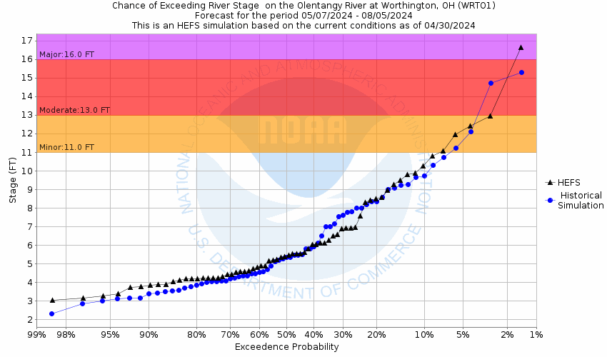
Potential River Levels - Used to
Potential River Levels
Used to Estimate the Chance of Flooding and the Range of Possible River Levels
10 Day (HEFS) 10 Day (NAEFS) River Forecast VS. River Potential
HEFS Ensemble NAEFS Ensemble Outlook vs. Forecast

Note: Use the official hydrograph at the top of this web page for river levels within the next 72 hours.

See the Product Description Document link for more details on the interpretation of the 10 day graphics.

Click individual graphics to enlarge.

Collaborative Agencies Collapse
The National Weather Service prepares its forecasts and other services in collaboration with agencies like the US Geological Survey, US Bureau of Reclamation, US Army Corps of Engineers, Natural Resource Conservation Service, National Park Service, ALERT Users Group, Bureau of Indian Affairs, and many state and local emergency managers across the country. For details, please click here.
NWS Information
National Weather Service
Wilmington Weather Forecast Office
1901 South State Route 134
Wilmington, OH 45177
(937) 383-0031
Ask Questions/Webmaster
Page last modified: 2-Nov-2020 7:30 PM
Disclaimer
Credits
Glossary
Privacy Policy
About Us
Career Opportunities