Skip Navigation Link weather.gov  
NOAA logo - Click to go to the NOAA homepage National Weather Service NWS logo - Click to go to the NWS homepage
Advanced Hydrologic Prediction Service
Image background of Navigation bar Left
Navigation Bar End Cap


This probabilistic forecast is issued by the Ohio River Forecast Center.
tab left off Hydrograph tab right off tab left off River at a Glance tab right off tab left off Download tab right off tab left on tab right on
About this graph
Forecasts for the Wabash River at Covington are issued as needed during times of high water, but are not routinely available.
Return to Area Map

Upstream Gauge - at Lafayette Upstream Gauge Downstream Gauge Downstream Gauge - at Montezuma
Zoom Level:15
Flood Categories (in feet)
Major Flood Stage: 29
Moderate Flood Stage: 24
Flood Stage: 16
Action Stage: 11
Low Flow (in KCFS): 1.04

Historic Crests
(1) 35.10 ft on 03/27/1913
(2) 32.44 ft on 05/20/1943
(3) 30.27 ft on 06/14/1958
(4) 28.92 ft on 04/21/2013
(5) 28.90 ft on 07/11/2003
(6) 28.90 ft on 02/29/1936
(7) 28.64 ft on 01/15/2005
(8) 28.50 ft on 01/07/1950
(9) 28.41 ft on 02/13/1959
(10) 28.39 ft on 02/25/1985
Show More Historic Crests

(P): Preliminary values subject to further review.

Recent Crests
(1) 22.13 ft on 01/29/2024 (P)
(2) 17.95 ft on 04/03/2023 (P)
(3) 23.18 ft on 03/07/2023 (P)
(4) 19.16 ft on 05/09/2022 (P)
(5) 20.08 ft on 03/26/2022 (P)
(6) 19.98 ft on 01/01/2022 (P)
(7) 21.01 ft on 10/28/2021 (P)
(8) 20.80 ft on 05/12/2021 (P)
(9) 18.33 ft on 03/30/2021 (P)
(10) 19.30 ft on 03/03/2021 (P)
Show More Recent Crests

(P): Preliminary values subject to further review.

Low Water Records
(1) 1.20 ft on 10/05/1928
(2) 1.80 ft on 07/31/1939
(3) 1.80 ft on 09/20/1941
(4) 2.30 ft on 08/27/1932
(5) 3.60 ft on 07/19/2012
KML Image
Gauge LocationGauge Map Marker
Disclaimer
Latitude/Longitude Disclaimer: The gauge location shown in the above map is the approximate location based on the latitude/longitude coordinates provided to the NWS by the gauge owner.
Flood Impacts & Photos Collapse
If you notice any errors in the below information, please contact our Webmaster
35.1 Record flood is in progress.
34.5 Water is at bottom of U.S. Highway 136 bridge. Near record flood is in progress.
32 Flood affects possibly as many as 250 families and causes major damage to as many as 40 homes.
30 Six or 7 homes downstream of gage in Covington begin to flood. Access road behind the cottages floods.
29 Major flood in progress. Extensive rural flooding in Warren, Fountain and Vermillion Counties. Many local roads are flooded. Several river communities are flooded. Water Street and lowest portion of Jefferson Street begin to flood in Covington.
28 At 28 feet River Road would flood.
27 Covington Lion's Club begins to flood. First floor flooding begins in some cottages across river in Warren County. Over topping of agricultural levees occurs. Crocket Street in Covington begins to flood as well as some rural residential property just north of Covington.
26.5 State Road 234 near Lodi begins to flood. Homes are affected along Warren CR South on opposite side of river.
26 The approach to the Independence Bridge floods.
25.6 The Wabash River is nearly 3 miles wide along SR 234 by backing up into Coal Creek on the west side of Lodi and the Vermillion River on the north side of Cayuga. Flood waters are at the edge of the north side of SR 234 but not on the road. North Sandhill Road and W CR 260 N on the northeast side of Covington extensively flooded in places. Silver Island Road just south of SR 32 is impassable.
25 Many local roads are impassable. High water backs up into Mud Run, cutting off some county roads just northwest of Covington. North Sandhill Road begins to flood from Mallory Branch. Mud Creek extensively floods W CR 260 N and Sandhill Road by backwater from the Wabash River.
24 Basement flooding begins in 10 to 12 cottages. The approach to new bridge downstream of SR 28 in Attica floods.
23 Flood water is at critical height for most agricultural levees.
21 Lanes to river residences west of South River Road south of Covington flooded. Sandhill Road at Mud Run just northeast of Covington begins to flood. Extensive lowland flooding in progress. Higher bottomlands flood.
20.5 Williamsport Road may begin to flood in Fountain County.
20 A few county roads begin to flood. Higher bottomlands begin to flood. The first cottage upstream from U.S. 136 bridge may become isolated by high water.
18 Five Crossings, a local county river park at old U.S. Highway 136 bridge site, begins to flood.
17.5 Some low agricultural fields flood. Backyard flood of cottages a short distance north of U.S. Highway 136. High water blocks land access to at least one residence.
16 Low agricultural lands begin to flood. Backyard flooding of cottages on right bank starts a short distance upstream of gage. Critical stage of Young-Neal Levee is reached.
Photos
(1) Silver Island and Liberty Church Roads Dec 31, 2008
(2) Silver Island Rd just south of SR 32 Dec 31, 2008
(3) Sand Hill Road Dec 31, 2008
(4) North of Williamsport Road Dec 31, 2008
(5) South of Williamsport Road Dec 31, 2008
(6) Williamsport Road Dec 31, 2008
(7) Fountain CR500 E will flood, but not on Dec 31, 2008
(8) Independence Road will flood, but not on Dec 31, 2008
(9) Potawatomi Park Dec 31, 2008
(10) Williamsport River Park Dec 31, 2008
(11) North of US 136 at Covington Dec 31, 2008
(12) South of US 136 at Covington Dec 31, 2008
(13) A low Wabash River at Covington looking south on March 27, 2003.
(14) A low Wabash River at Covington looking northwest on March 27, 2003.

Other Real-time and/or Archive Data Sources:

Additional Information Collapse
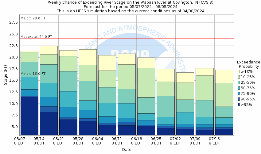
Potential River Levels - Used to
Potential River Levels
Used to Estimate the Chance of Flooding and the Range of Possible River Levels
10 Day (HEFS) 10 Day (NAEFS) 10 Day (GEFS)
HEFS Ensemble NAEFS Ensemble GEFS Ensemble

Note: Use the official hydrograph at the top of this web page for river levels within the next 72 hours.

Click individual graphics to enlarge.

Collaborative Agencies Collapse
The National Weather Service prepares its forecasts and other services in collaboration with agencies like the US Geological Survey, US Bureau of Reclamation, US Army Corps of Engineers, Natural Resource Conservation Service, National Park Service, ALERT Users Group, Bureau of Indian Affairs, and many state and local emergency managers across the country. For details, please click here.
NWS Information
National Weather Service
Indianapolis Weather Forecast Office
6900 West Hanna Ave.
Indianapolis, IN 46241
(317) 856-0360
Ask Questions/Webmaster
Page last modified: 2-Nov-2020 7:30 PM
Disclaimer
Credits
Glossary
Privacy Policy
About Us
Career Opportunities