Skip Navigation Link weather.gov  
NOAA logo - Click to go to the NOAA homepage National Weather Service NWS logo - Click to go to the NWS homepage
Advanced Hydrologic Prediction Service
Image background of Navigation bar Left
Navigation Bar End Cap


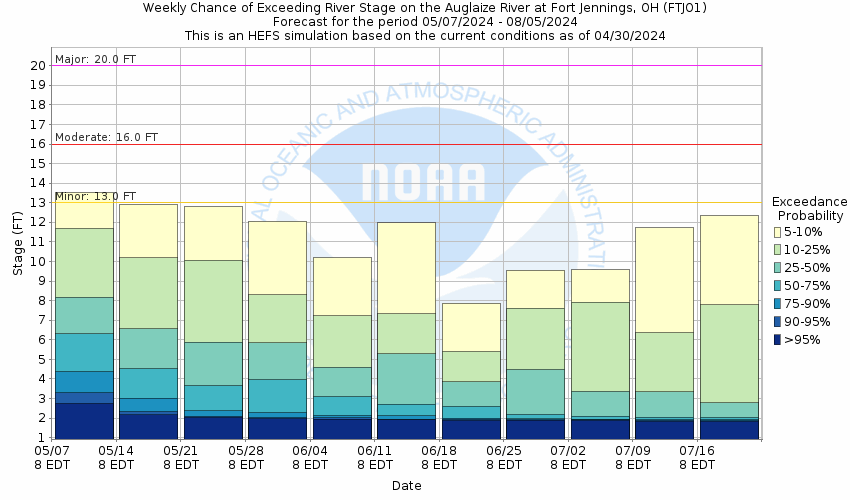
This probabilistic forecast is issued by the Ohio River Forecast Center.
tab left off Hydrograph tab right off tab left off River at a Glance tab right off tab left off Download tab right off tab left on tab right on
About this graph
Forecasts for the Auglaize River at Ft. Jennings are issued as needed during times of high water, but are not routinely available.
Return to Area Map

Downstream Gauge Downstream Gauge - near Defiance
Zoom Level:16
Flood Categories (in feet)
Major Flood Stage: 20
Moderate Flood Stage: 16
Flood Stage: 13
Action Stage: 11
Low Stage (in feet): -9999

Historic Crests
(1) 20.30 ft on 01/23/1959
(2) 19.76 ft on 07/15/1992
(3) 19.44 ft on 02/07/2008
(4) 19.41 ft on 02/07/2008
(5) 19.07 ft on 02/11/1959
Show More Historic Crests

(P): Preliminary values subject to further review.

Recent Crests
(1) 14.54 ft on 05/11/2021 (P)
(2) 13.73 ft on 05/20/2020
(3) 18.99 ft on 05/18/2019
(4) 14.28 ft on 11/03/2018
(5) 13.33 ft on 07/24/2017
Show More Recent Crests

(P): Preliminary values subject to further review.

Low Water Records
(1) 1.41 ft on 09/25/2008
(2) 1.50 ft on 06/21/2012
(3) 1.53 ft on 09/07/2020
Show More Low Water Records
KML Image
Gauge LocationGauge Map Marker
Disclaimer
Latitude/Longitude Disclaimer: The gauge location shown in the above map is the approximate location based on the latitude/longitude coordinates provided to the NWS by the gauge owner.
Flood Impacts & Photos Collapse
If you notice any errors in the below information, please contact our Webmaster
21.4 Flood water begins to hit the bottom of the bridge at the gage site.
20 A major flood is in progress. Extensive inundation and damage of property can be expected. Many primary roads and bridges will be closed and numerous evacuations will be necessary.
16 Moderate flooding begins along the Auglaize River with secondary roads and agricultural lands as well as homes nearest the river being affected by flood waters. Some evacuations of people and property may be necessary.
13 Minor flooding begins in the northwest Ohio counties of northwest Allen, northeast Van Wert, and southwest Putnam. Farm land nearest the Auglaize river will be affected by flood water.
Photos
(1) Looking Upstream
(2) Looking Downstream

Other Real-time and/or Archive Data Sources:

Additional Information Collapse
Potential River Levels - Used to
Potential River Levels
Used to Estimate the Chance of Flooding and the Range of Possible River Levels
10 Day (HEFS) 10 Day (NAEFS) River Forecast VS. River Potential
HEFS Ensemble NAEFS Ensemble Outlook vs. Forecast

Note: Use the official hydrograph at the top of this web page for river levels within the next 72 hours.

Click individual graphics to enlarge.


Gauge zero transitioned from 713.60 NGVD29 to 712.99 NAVD88 on Oct 1, 2011.


USGS River Gauge Camera Auglaize River near Fort Jennings
Collaborative Agencies Collapse
The National Weather Service prepares its forecasts and other services in collaboration with agencies like the US Geological Survey, US Bureau of Reclamation, US Army Corps of Engineers, Natural Resource Conservation Service, National Park Service, ALERT Users Group, Bureau of Indian Affairs, and many state and local emergency managers across the country. For details, please click here.
NWS Information
National Weather Service
Northern Indiana Weather Forecast Office
7506 E 850 N
Syracuse, IN 46567
(574) 834-1104
Ask Questions/Webmaster
Page last modified: 2-Nov-2020 7:30 PM
Disclaimer
Credits
Glossary
Privacy Policy
About Us
Career Opportunities