Skip Navigation Link weather.gov  
NOAA logo - Click to go to the NOAA homepage National Weather Service NWS logo - Click to go to the NWS homepage
Advanced Hydrologic Prediction Service
Image background of Navigation bar Left
Navigation Bar End Cap


This probabilistic forecast is issued by the Ohio River Forecast Center.
tab left off Hydrograph tab right off tab left off River at a Glance tab right off tab left off Download tab right off tab left on tab right on
About this graph
Forecasts for the Salamonie River near Warren are issued as needed during times of high water, but are not routinely available.
Return to Area Map

Upstream Gauge - at Portland Upstream Gauge
Zoom Level:16
Flood Categories (in feet)
Major Flood Stage: 17
Moderate Flood Stage: 15
Flood Stage: 12
Action Stage: 10
Low Stage (in feet): -9999

Historic Crests
(1) 16.94 ft on 03/06/1963
(2) 16.82 ft on 08/05/1998
(3) 16.21 ft on 03/18/1978
(4) 16.21 ft on 12/30/1990
Show More Historic Crests

(P): Preliminary values subject to further review.

Recent Crests
(1) 13.02 ft on 05/10/2021
(2) 13.38 ft on 01/12/2020
(3) 14.40 ft on 05/27/2019
(4) 11.78 ft on 04/04/2018
Show More Recent Crests

(P): Preliminary values subject to further review.

Low Water Records
Currently none available.
KML Image
Gauge LocationGauge Map Marker
Disclaimer
Latitude/Longitude Disclaimer: The gauge location shown in the above map is the approximate location based on the latitude/longitude coordinates provided to the NWS by the gauge owner.
Flood Impacts & Photos Collapse
If you notice any errors in the below information, please contact our Webmaster
17.2 Flood water begins to hit the bottom of the bridge at the gage site.
17 Major flooding is in progress with extensive inundation and damage. Many primary roads and bridges are closed. Evacuations from flood prone areas are necessary.
15 Moderate flooding can be expected. Secondary roads are blocked and the transfer of property to higher ground is necessary.
12 The river reaches flood stage with minor flooding of low agricultural land and roads nearest the river. Belleville Road and East Flowing Well Road northwest of Warren become impassable and isolated nearby residences.
Photos
(1) Upstream view from Warren Gauge
(2) Downstream view from Warren Gauge

Other Real-time and/or Archive Data Sources:

Additional Information Collapse
Gauge transitioned from 784.65 NGVD29 to 784.42 NAVD88 on May 7, 2019. Potential River Levels - Used to
Potential River Levels
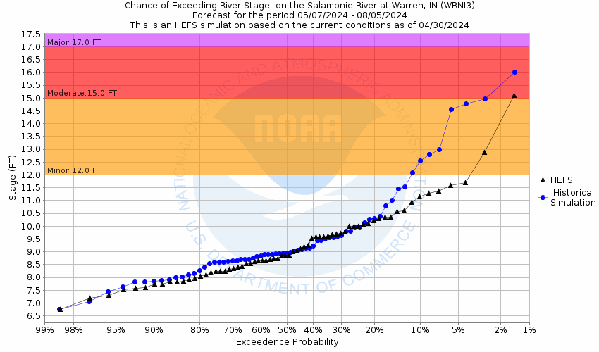
Used to Estimate the Chance of Flooding and the Range of Possible River Levels
10 Day (HEFS) 10 Day (NAEFS) River Forecast VS. River Potential
HEFS Ensemble NAEFS Ensemble Outlook vs. Forecast

Note: Use the official hydrograph at the top of this web page for river levels within the next 72 hours.

Click individual graphics to enlarge.

Collaborative Agencies Collapse
The National Weather Service prepares its forecasts and other services in collaboration with agencies like the US Geological Survey, US Bureau of Reclamation, US Army Corps of Engineers, Natural Resource Conservation Service, National Park Service, ALERT Users Group, Bureau of Indian Affairs, and many state and local emergency managers across the country. For details, please click here.
NWS Information
National Weather Service
Northern Indiana Weather Forecast Office
7506 E 850 N
Syracuse, IN 46567
(574) 834-1104
Ask Questions/Webmaster
Page last modified: 2-Nov-2020 7:30 PM
Disclaimer
Credits
Glossary
Privacy Policy
About Us
Career Opportunities