Skip Navigation Link weather.gov  
NOAA logo - Click to go to the NOAA homepage National Weather Service NWS logo - Click to go to the NWS homepage
Advanced Hydrologic Prediction Service
Image background of Navigation bar Left
Navigation Bar End Cap


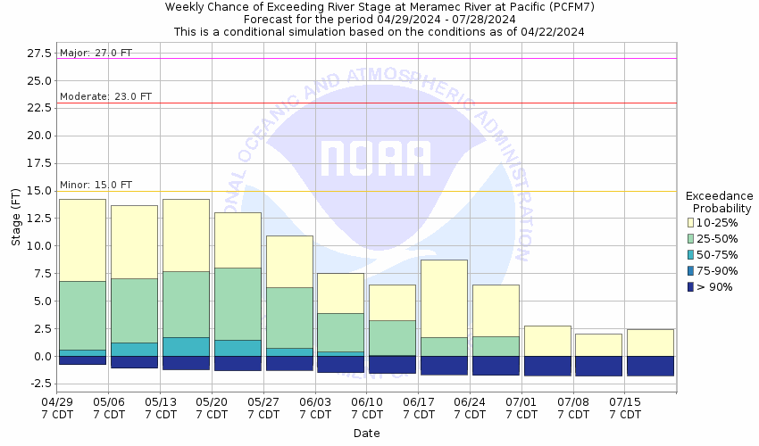
This probabilistic forecast is issued by the North Central River Forecast Center.
tab left off Hydrograph tab right off tab left off River at a Glance tab right off tab left off Download tab right off tab left on tab right on
About this graph
Forecasts for the Meramec River near Pacific are issued as needed during times of high water, but are not routinely available.
Return to Area Map

Upstream Gauge - near Sullivan Upstream Gauge Downstream Gauge Downstream Gauge - near Eureka
Zoom Level:14
Flood Categories (in feet)
Major Flood Stage: 27
Moderate Flood Stage: 23
Flood Stage: 15
Action Stage: 13
Low Stage (in feet): -9999

Historic Crests
(1) 33.42 ft on 12/30/2015
(2) 33.05 ft on 05/02/2017
(3) 32.71 ft on 12/06/1982
(4) 29.60 ft on 03/22/2008
(5) 28.91 ft on 04/14/1994
(6) 24.73 ft on 11/17/1993
(7) 23.50 ft on 11/22/1985
(8) 23.20 ft on 06/20/1985
(9) 22.30 ft on 05/20/1995
(10) 21.61 ft on 05/08/2000
Show More Historic Crests

(P): Preliminary values subject to further review.

Recent Crests
(1) 20.25 ft on 03/27/2023 (P)
(2) 17.08 ft on 03/06/2023 (P)
(3) 19.97 ft on 01/14/2020
(4) 15.42 ft on 03/30/2018
(5) 18.82 ft on 02/27/2018
(6) 33.05 ft on 05/02/2017
(7) 33.42 ft on 12/30/2015
(8) 16.59 ft on 04/21/2013
(9) 19.13 ft on 04/29/2011
(10) 21.14 ft on 11/02/2009
Show More Recent Crests

(P): Preliminary values subject to further review.

Low Water Records
(1) -2.50 ft on 08/04/1972
(2) -2.14 ft on 10/01/2014
(3) -2.00 ft on 07/29/2012
Show More Low Water Records
KML Image
Gauge LocationGauge Map Marker
Disclaimer
Latitude/Longitude Disclaimer: The gauge location shown in the above map is the approximate location based on the latitude/longitude coordinates provided to the NWS by the gauge owner.
Flood Impacts & Photos Collapse
If you notice any errors in the below information, please contact our Webmaster
33.8 Near this height, the Husky Corporation and the Pro Roller Company along Industrial Drive at Denton Road begin flooding.
33.5 The BNSF RR tracks act as a levee protecting the eastern two-thirds of Pacific. Near this height, these tracks may be overtopped.
32.8 Near this height, Interstate 44 may close in both directions east of mile marker 254.0. This occurred during the December 2015 flood.
32.7 Backwater from Calvey Creek will force the closure of Missouri State Route O east of Robertsville near this height.
31 Railroad tracks begin to flood. This did not happen in 2015 as water
29.7 The clubhouse at the St. Louis Skeet and Trap Club begins to flood.
29.5 Near this height, the Graphic Packaging International Company begins flooding at Denton Road and Jefferson Street.
28.9 The Olympic Shooting Facility at the St. Louis Skeet and Trap Club is flooded.
28.8 Route 66 (Missouri Route O) is closed in both directions from just east of Pacific to Six Flags Road in Allenton.
27.5 East Osage Street (Route 66) is closed.
27.2 Missouri State Route O west of Robertsville State Park begins flooding near this level.
27 20 to 30 residences become subject to flooding. Major flooding begins.
26 Highways F & O begin to flood, cutting off access to Pacific from the south.
25.5 Denton Road from the Industrial Park south is closed.
25 East Congress between Columbus and Olive are flooded in City of Pacific.
24.4 Highway F & O at Brush Creeks is flooded and closed.
23.5 Water begins flooding the grounds at the St. Louis Skeet and Trap Club east of Pacific.
23 The lift station property at East Congress and Elm Street begins flooding near this height.
22.6 Four houses near the gage begin to flood at this stage.
22 Jefferson Street extension is flooded and closed. Dogpound at the east end of East Congress Street begins to flood.
19.39 Private road under the Highway F bridge becomes flooded at this height.
18.6 Horneker Road begins to flood near this height.
18 The left bank begins to overflow.
17.5 Private road under the Highway F bridge begins flooding near this height.
17 State Highway AK begins flooding near the intersection with State Highway O near this height.
16.5 Opeechee Beach Road is flooded and closed.
16.2 Opeechee Beach Road begins flooding.
16 Route N begins to flood.
15.4 Hunters Ford Road is closed near this height.
15 Flood Stage. Farm and pasture land begins to flood. Minor flooding begins.
Photos
(1) Highway F is inundated just north of bridge during flood of May 2017.
(2) Areal view of southeast Pacific - March 2008
(3) Southeast Pacific - March 2008
(4) Farm property off of Highway N south of the Meramec River on March 21, 2008 near a stage of 29.5 ft.
(5) Looking west from the Highway N bridge on March 21, 2008 with a stage near 29.5 feet.
(6) Pacific Street looking east from 3rd Street on March 21, 2008 with a stage near 29.5 ft.
(7) Looking east along Meramec Street near 3rd Street on March 21, 2008 with a stage near 29.5 ft.
(8) Looking south along 4th Street near Watson Street on March 21, 2008 with a stage near 29.5 ft.
(9) Orleans St. at 2nd St. looking east on March 21, 2008 with a stage near 29.3 ft.
(10) 2nd Street at Orleans Street in Pacific on March 21, 2008 with a stage near 29.2 ft.
(11) Pacific Youth Association ball fields on March 21, 2008 with a stage near 29.2 feet.
(12) Looking south along Denton Rd. south of Industrial Ct. on March 22, 2008 with a stage near 26.3 ft.
(13) Clubhouses along the Meramec River just north of Hwy. F on March 20, 2008 near 22 ft..
(14) View of Pacific gauge on March 21, 2008
(15) Pacific Looking Upstream
(16) Pacific Looking Downstream

Other Real-time and/or Archive Data Sources:

Additional Information Collapse
How low could the river get?
Collaborative Agencies Collapse
The National Weather Service prepares its forecasts and other services in collaboration with agencies like the US Geological Survey, US Bureau of Reclamation, US Army Corps of Engineers, Natural Resource Conservation Service, National Park Service, ALERT Users Group, Bureau of Indian Affairs, and many state and local emergency managers across the country. For details, please click here.
NWS Information
National Weather Service
St. Louis Weather Forecast Office
12 Missouri Research Park Drive
St. Charles, MO 63304
(636) 441-8467
Ask Questions/Webmaster
Page last modified: 2-Nov-2020 7:29 PM
Disclaimer
Credits
Glossary
Privacy Policy
About Us
Career Opportunities