Historic Crests
(1) 33.23 ft on 05/02/2010
(2) 24.34 ft on 02/13/1948
(3) 24.27 ft on 03/13/1975
(4) 22.30 ft on 03/23/1929
(5) 22.18 ft on 03/22/1955 Show More Historic Crests
(P): Preliminary values subject to further review.
Recent Crests
(1) 16.04 ft on 04/23/2017
(2) 13.27 ft on 12/25/2015
(3) 15.42 ft on 02/22/2015
(4) 16.54 ft on 04/29/2014
(5) 17.73 ft on 04/29/2013 Show More Recent Crests
(P): Preliminary values subject to further review.
Latitude/Longitude Disclaimer: The gauge location shown in the above map
is the approximate location based on the latitude/longitude coordinates
provided to the NWS by the gauge owner.
Flood Impacts & Photos
If you notice any errors in the below information, please contact our Webmaster
34
Record flooding impacts many roads and properties along and near the river from the Grassland area north of Franklin, through Bellevue, to near Pegram. Water reaches I-40 between exit 192 and 196, reaches businesses in the Bellevue Place shopping center, and buildings at Ensworth High School. Water approaches Grassland Middle School, and McCrory Ln between I-40 and U.S. 70S and may be impassable at higher levels.
32
Major flooding continues to impact Hwy 100, Hwy 70, Old Harding Pike, Sneed Rd, and Coley Davis Rd. Businesses in the Harpeth Village shopping center are impacted, as well as the River Rest, Riverwalk, Horseshoe Bend, River Plantation, Riverside, Somerset Farms, The Meadows, and Avondale Park neighborhoods. Water approaches I-40 between exit 192 and 196, impacts a significant portion of the TVA substation on Coley Davis Rd, and approaches businesses in the Bellevue Place shopping center.
30
Widespread flooding continues to impact homes, properties, and roads including Hwy 100, Hwy 70, and Old Harding Pike, Sneed Rd, and Coley Davis Rd. Businesses in the Harpeth Village shopping center are impacted, as well as homes on and near Boxwood Dr and Blue Springs Rd in River Rest, and in the Riverwalk, Horseshoe Bend, River Plantation, Riverside, Somerset Farms, The Meadows, and Avondale Park neighborhoods.
28
Widespread flooding is impacting homes, properties, and roads including Hwy 100, Hwy 70, and Old Harding Pike, and covers Sneed Rd and Hunters Trail. Water reaches businesses in the Harpeth Village shopping center, and covers Collins Rd preventing access to the Bellevue YMCA center and BellePAC. Water approaches homes in the Riverwalk, Horseshoe Bend, River Plantation, Somerset Farms, The Meadows, and Avondale Park neighborhoods, and homes on Boxwood Dr. Water approaches Coley Davis Rd near Hwy 70S.
26
Significant flooding continues to impact roadways including portions of Hwy 100, Hwy 70, Old Harding Pike, and Newsome Station Rd. Some homes in neighborhoods impacted include Harpeth Valley Park, Temple Gate, Boone Trace, River Rest, Morton Mill Rd in Riverside, Sawyer Bend Rd, and near Harpeth Bend Dr and McPherson Dr. Water approaches Sneed Rd between Vaughan Rd and Old Natchez Trace, and Coley Davis Rd on Hutton Bend, and approaches businesses in the Harpeth Village shopping center.
24
Significant flooding impacts many roads including Hwy 100 at Temple Rd, Hwy 70 between Newsome Station Rd and McCrory Ln, and Old Harding Pike. Properties begin to be impacted on Harpeth Bend Dr and Beech Bend Dr in Harpeth Valley Park, on Harpeth Bend Dr and McPherson Dr, and in the Temple Gate neighborhood. Water approaches Hwy 100 near the river and near Trace Creek Dr, and Newsome Station Rd restricting access to the Merrymount Acres neighborhood at higher levels.
22
Flooding continues to impact roads including Old Harding Pike near Morton Mill Rd, Morton Mill Rd between Northridge Dr and Bay Cove Trl, Moran Rd, and Newsome Station Rd. Properties are also impacted in the 7800 block of Hwy 100, on Old Natchez Trace near Sneed Rd, on Temple Rd south of Hwy 100, and the Ensworth High School athletic facilities. Water approaches Hwy 70 between Newsome Station Rd and McCrory Ln, and Hwy 100 at Temple Rd which may be impassable at higher levels.
20
Flooding along the river impacts many roads including Old Harding Pike near Morton Mill Rd, Morton Mill Rd between Northridge Dr and Bay Cove Trl, Moran Rd, and Newsome Station Rd. Water also begins to impact properties adjacent to the river in the 7800 block of Hwy 100, on Old Natchez Trace near Sneed Rd, and reaches the Ensworth High School athletic structures and facilities. Water approaches properties on Temple Rd south of Hwy 100.
18
Areas along the river, including recreational facilities and the athletic fields at Ensworth High School, continue to be impacted by high water. Moran Rd and Newsome Station Rd are impassable, and water approaches Old Harding Pike near Morton Mill Rd which may be impassable at higher levels. Water also begins to impact properties adjacent to the river in the 7800 block of Hwy 100, and on Old Natchez Trace near Sneed Rd.
16
Water continues to inundate low lying areas along the river including portions of the Harpeth River Greenway, the Old Natchez Country Club golf course, Reese Smith Jr baseball fields, the Harpeth Valley Golf Center, and the HYSA soccer complex. Moran Rd and Newsome Station Rd near the river are impassable. Water approaches the Ensworth High School athletic fields and Old Harding Pike near Morton Mill Rd.
14
Low lying areas along the river begin to be inundated, including portions of the Harpeth River Greenway, Moran Rd, Old Natchez Country Club golf course, Reese Smith Jr baseball fields, the parking lot at the Harpeth Valley Golf Center, the HYSA soccer complex, and Newsome Station Rd near the river which is impassable at higher levels.
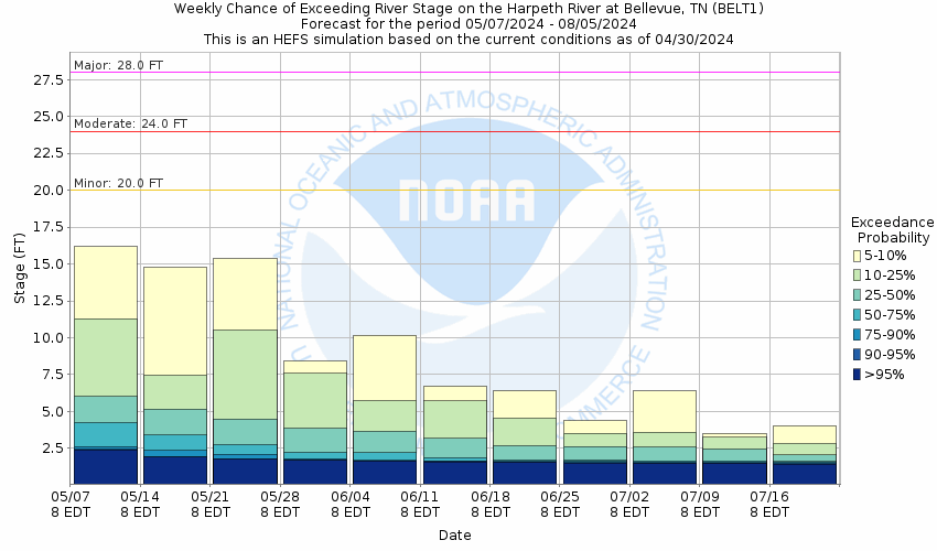
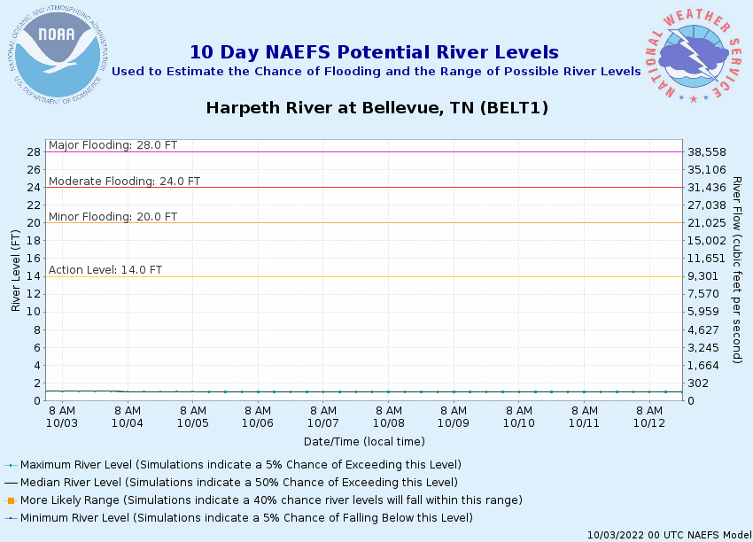
Potential River Levels Used to Estimate the Chance of Flooding and
the Range of Possible River Levels
10 Day (HEFS)
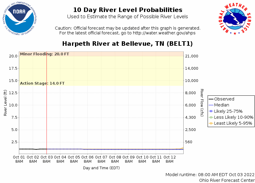
7 Day (NAEFS)
7 Day (GEFS)
Note: Use the official hydrograph at the top of this web page
for river levels within the next 72 hours.
Click individual graphics to
enlarge.
Collaborative Agencies
The National Weather Service prepares its forecasts and other services in collaboration with agencies like the US Geological Survey, US Bureau of Reclamation, US Army Corps of Engineers, Natural Resource Conservation Service, National Park Service, ALERT Users Group, Bureau of Indian Affairs, and many state and local emergency managers across the country. For details, please click here.
NWS Information
National Weather Service
Nashville Weather Forecast Office
500 Weather Station Road
Old Hickory, TN 37138
(615) 754-4633 Ask Questions/Webmaster
Page last modified: 2-Nov-2020 7:29 PM