Historic Crests
(1) 59.20 ft on 03/01/1826
(2) 57.30 ft on 02/01/1918
(3) 57.25 ft on 12/29/1926
(4) 54.80 ft on 03/27/1929
(5) 54.50 ft on 03/01/1902
(6) 54.09 ft on 01/12/1946
(7) 53.83 ft on 01/23/1937
(8) 52.46 ft on 02/05/1950
(9) 52.02 ft on 01/02/1943
(10) 52.01 ft on 02/17/1948 Show More Historic Crests
(P): Preliminary values subject to further review.
Recent Crests
(1) 22.35 ft on 05/06/2017
(2) 25.58 ft on 02/17/2016
(3) 26.17 ft on 04/16/2015
(4) 24.33 ft on 02/05/2014
(5) 25.50 ft on 04/28/2013
(6) 37.62 ft on 05/03/2010
(7) 19.66 ft on 01/23/2006
(8) 25.50 ft on 12/01/2004
(9) 23.80 ft on 05/07/2003
(10) 26.30 ft on 02/23/2003 Show More Recent Crests
(P): Preliminary values subject to further review.
Latitude/Longitude Disclaimer: The gauge location shown in the above map
is the approximate location based on the latitude/longitude coordinates
provided to the NWS by the gauge owner.
Flood Impacts & Photos
If you notice any errors in the below information, please contact our Webmaster
53
Significant flooding continues to impact the Cumberland River and the adjacent tributaries across Clay County. Numerous residential, commercial, and municipal properties and structures are impacted in and around Celina, and many primary roads are affected by flood waters. This includes Hwy 53 near Mill Creek, and Hwy 52 west of Celina. Water approaches portions of Hwy 53 east of Celina near the Moody Boat Ramp, and may impact travel at higher levels.
50
Significant flooding is occurring along the river and the adjacent tributaries, with numerous residential, commercial, and municipal properties and structures impacted across Clay County. Locations include areas north and east of Lake Ave and west of Williamson St in Celina, the Dale Hollow Dam Campground, Clay County High School, Induistrial Dr, Moss Arcot Rd, properties in Weaver Bottom, portions of Hwy 53 near Mill Creek, and farm structures on Old Watson Rd.
48
Widespread flooding continues to affect numerous properties and structures along the river and in areas around Celina. Impacted locations include areas north and east of Lake Ave, areas west of Mitchell St, the Dale Hollow Dam Campground, and homes on Inudstrial Dr. Floodwaters have reached the high school building, portions of Moss Arcot Rd, properties in Weaver Bottom, and are approaching portions of Hwy 53 near Mill Creek and farm structures on Old Watson Rd.
45
Widespread flooding along the river and the adjacent tributaries is occurring, with many agricultural, residential, commercial, and municipal properties and structures impacted. In Celina, locations north and east of Lake Ave, and west of Mitchell St are impacted, as well as most of the Dale Hollow Dam Campground, and properties and structures on Industrial Dr. Water approaches the high school building, portions of Moss Arcot Rd, and properties on River Bend Dr in Weaver Bottom.
43
Agricultural areas and other properties along the river, as well as the adjacent tributaries are flooded. In Celina, residential, commercial, and municipal properties and structures close to the Obey and Cumberland Rivers are impacted, espcially areas north and east of Lake Ave, and west of Mitchell St. Many roads that access these areas are impassable. Water approaches properties on Industrial Dr, and begins to impact the Dale Hollow Dam Campground.
40
Flooding begins in and around Celina, affecting homes and properties on West Lake Rd, Clark Cir, Breyer St, Cumberland Dr, Waterview Dr, Waterview Ln, Waste Water Rd, River Dr, Yale Dr, the Riverside neighborhood, River Rd, and Ross Boles Rd. Water approaches the County Circuit Court building, the County Road Commission office, and properties on Spring St and River Ave.
33
Water begins to impact low lying areas along the river and the adjacent tributaries, including Kettle Creek, Proctor Creek, Obey River, Knob Creek, and Mill Creek. Water approaches the atheltic fields at Clay County High School, the Clay County Park, and properties along Breyer St and Waste Water Rd.
30
Water begins to impact low lying areas along the river and the adjacent tributaries, including Kettle Creek, Proctor Creek, Obey River, Knob Creek, and Mill Creek. Water approaches the atheltic fields at Clay County High School, the Clay County Park, and properties along Breyer St and Waste Water Rd.
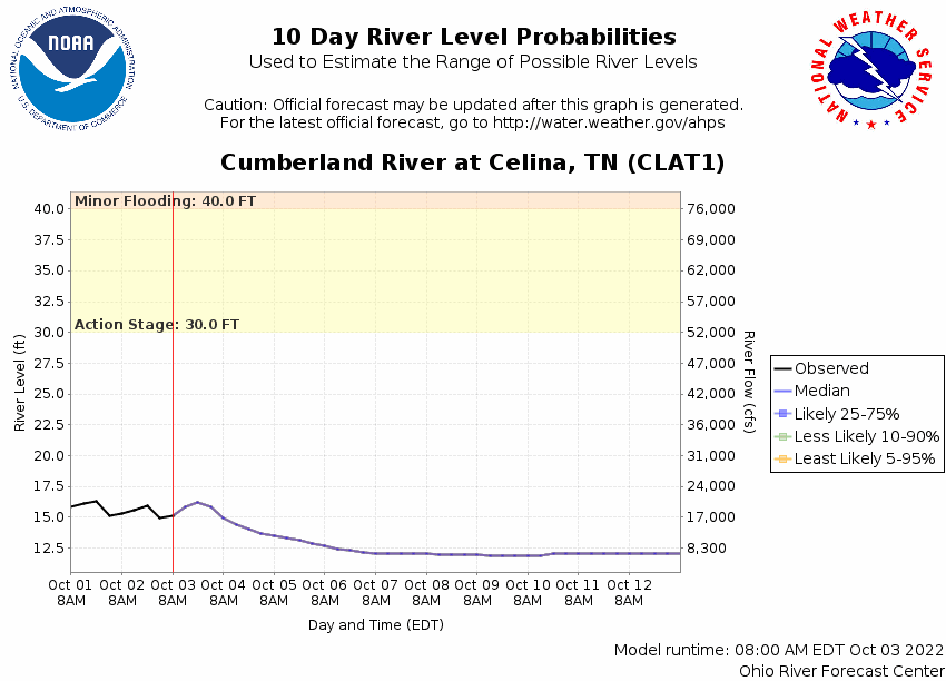
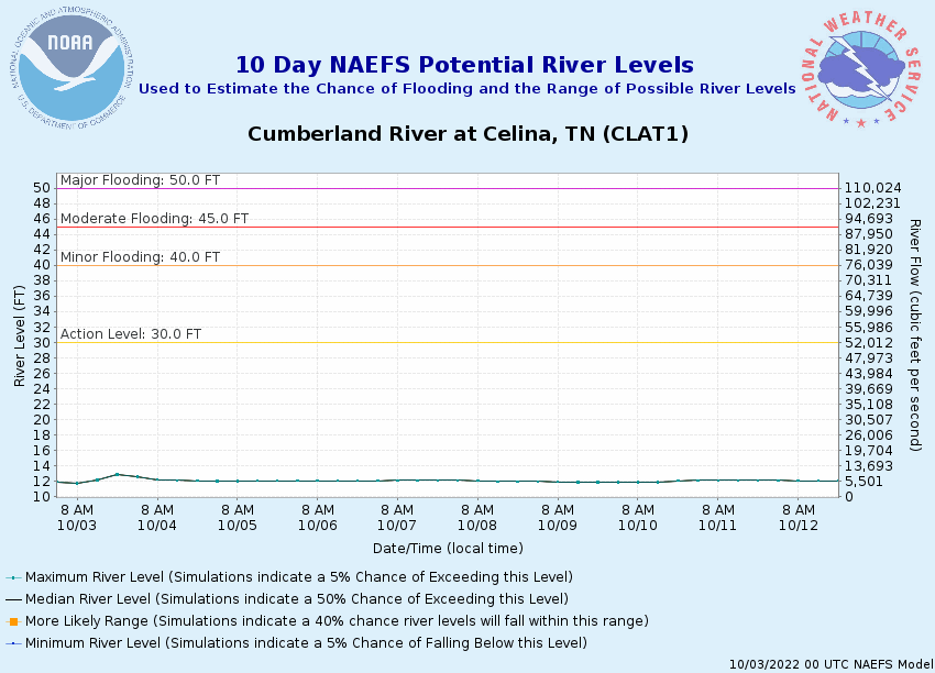
Potential River Levels Used to Estimate the Chance of Flooding and
the Range of Possible River Levels
10 Day (HEFS)
7 Day (NAEFS)
7 Day (GEFS)
Note: Use the official hydrograph at the top of this web page
for river levels within the next 72 hours.
Click individual graphics to
enlarge.
Collaborative Agencies
The National Weather Service prepares its forecasts and other services in collaboration with agencies like the US Geological Survey, US Bureau of Reclamation, US Army Corps of Engineers, Natural Resource Conservation Service, National Park Service, ALERT Users Group, Bureau of Indian Affairs, and many state and local emergency managers across the country. For details, please click here.
NWS Information
National Weather Service
Nashville Weather Forecast Office
500 Weather Station Road
Old Hickory, TN 37138
(615) 754-4633 Ask Questions/Webmaster
Page last modified: 2-Nov-2020 7:29 PM