Historic Crests
(1) 56.20 ft on 01/01/1927
(2) 53.90 ft on 01/26/1937
(3) 52.55 ft on 05/03/2010
(4) 51.00 ft on 03/30/1929
(5) 49.90 ft on 02/05/1918
(6) 49.70 ft on 02/18/1948
(7) 48.90 ft on 01/15/1946
(8) 48.80 ft on 02/11/1939
(9) 48.60 ft on 02/10/1950
(10) 48.40 ft on 01/14/1913 Show More Historic Crests
(P): Preliminary values subject to further review.
Recent Crests
(1) 40.93 ft on 02/24/2019
(2) 29.77 ft on 04/24/2017
(3) 30.60 ft on 02/22/2015
(4) 28.73 ft on 02/05/2014
(5) 32.56 ft on 04/30/2013
(6) 28.84 ft on 01/26/2012
(7) 29.55 ft on 03/02/2011
(8) 52.55 ft on 05/03/2010
(9) 34.98 ft on 05/10/2009
(10) 32.15 ft on 04/04/2008 Show More Recent Crests
(P): Preliminary values subject to further review.
Low Water Records (1) -0.10 ft on 09/13/1881 (2) -0.10 ft on 11/03/1894 (3) 0.00 ft on 07/14/1881 Show More Low Water Records
Latitude/Longitude Disclaimer: The gauge location shown in the above map
is the approximate location based on the latitude/longitude coordinates
provided to the NWS by the gauge owner.
Flood Impacts & Photos
If you notice any errors in the below information, please contact our Webmaster
52
Most areas along the river are flooded. Affected locations on the east side include property at Korean Veterans and I-24, Nissan Stadium and surrounding areas, and property from James Robertson Pkwy, to Jefferson St, to the I-65 bridge. On the west side, affected locations include Anthes Dr, First Ave from Korean Veterans to Church St, areas of South Broadway up to Fifth Ave, north of downtown between James Robertson Pkwy and Jefferson St, Hope Gardens, Germantown and East Germantown.
50
In addition to ongoing extensive flooding around downtown Nashville on both sides of the river from the I-24 bridge to the I-65 bridge, flooding is also occurring at the Music City Star train station, areas in South Broadway between First Ave and Fifth Ave north of Korean Veterans Blvd, roads and property around Nissan Stadium, and buildings on First Ave North between Broadway and Church St.
49
Extensive flooding is occurring on both sides of the river. Impacted areas include Anthes Dr, Cowan St, Cowan Ct, Crutcher St, Davidson St, James Robertson Pkwy, Oldham St, Rosa Parks Blvd and Hope Gardens, north of downtown between James Robertson Pkwy and Jefferson St, East Germantown, Spring St, Sylvan St, North and South First St, and South Second St. Water also begins to impact areas around Nissan Stadium, the Music City Star train station, and the South Broadway area.
47
Many industrial and commercial properties and structures are flooded, including those near Anthes Dr, Cement Plant Rd, Cowan St, Cowan Ct, Crutcher St, Davidson St, First Ave North, Oldham St, Spring St, North First St, South First St, and South Second St. Water also begins to impact areas near Bicentennial Mall, Nashville Farmers Market, properties near Rosa Parks Blvd in the Hope Gardens Area, East Germantown, and areas north of downtown between James Robertson Pkwy and Jefferson St.
45
Flood waters are impacting industrial and commercial properties and structures, and area roads along the river from the I-24 bridge to the I-65 bridge. Specific locations include Davidson St, Anthes Dr, North First St, Oldham St, Cowan St, Cowan Ct, and Cement Plant Rd. Most of the riverfront recreational areas near Nissan Stadium, and portions of the Cumberland River Greenway are also flooded. Water begins to approach properties and roads on South First St, South Second St, and Crutcher St.
44
Industrial properties and structures along the river are impacted, and Cowan St and Cowan Ct are flooded and likely impassable. Water begins to approach property at the end of Anthes Dr, and cover portions of Davidson St, Cement Plant Rd, North First St, and Oldham St. These roads may be impassable at higher levels.
42
Riverfront park is flooded to the fourth grassy area, as well as other recreational and greenway areas along the river. Portions of Cowan St and Cowan Ct are flooded and may be ipassable. Industrial properties on Davidson St, North First St, Cowan St and Cowan Ct are also flooded.
41
Further flooding of inudstrial areas on Cement Plant Rd, Cowan St, Cowan Ct, and Davidson St is occurring. Water also approaches Cowan St and Cowan Ct and these roads may be closed at higher levels.
40
Flooding of property along the river from the I-24 bridge to the I-65 bridge is occurring, including industrial areas on Adams St, Cement Plant Rd, Cowan St, Cowan Ct, and Davidson St.
38
Water reaches the third grassy area of the riverfront landing, and is inundating other recreational and greenway areas along the river. Water also begins to approach industrial properties along the river on Adams St, Cement Plant Rd, Cowan St, Cowan Ct, and Davidson St.
37
Further inundation of the riverfront recreation areas near Nissan Stadium is occurring, as well as access points along the river and portions of the Cumberland River Greenway.
35
Low lying areas along the river from the I-24 bridge to the I-65 bridge are significantly inundated, including riverfront recreation areas and access points near Nissan Stadium. Industrial properties along the river should monitor further increases in river levels.
34
Water reaches the second grassy area of the riverfront landing and covers most of the recreation areas on the east side of the river near Nissan Stadium.
32
Further inundation of low lying areas along the river is occurring including the riverfront landing and receation areas near Nissan Stadium.
30
Water reaches the first grassy area of the riverfront landing, and the access point on the east side of the river near Nissan Stadium.
25
The riverfront recreation areas on both sides of the river begin to be inundated.
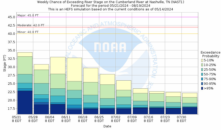
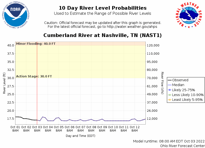
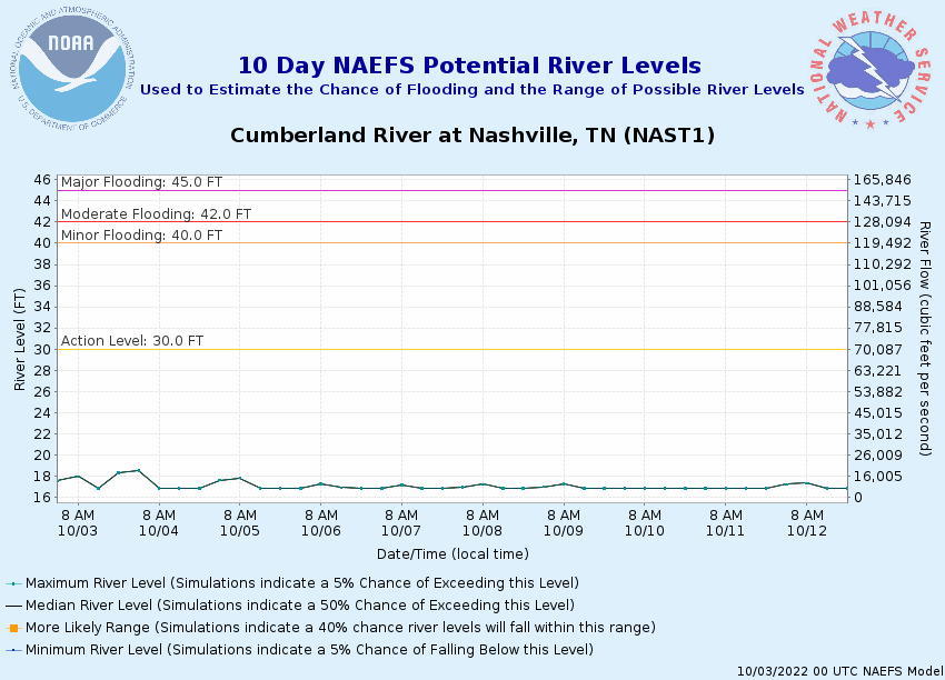
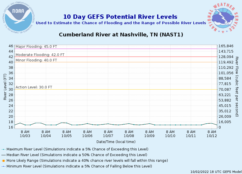
Potential River Levels Used to Estimate the Chance of Flooding and
the Range of Possible River Levels
10 Day (HEFS)
7 Day (NAEFS)
7 Day (GEFS)
Note: Use the official hydrograph at the top of this web page
for river levels within the next 72 hours.
Click individual graphics to
enlarge.
Collaborative Agencies
The National Weather Service prepares its forecasts and other services in collaboration with agencies like the US Geological Survey, US Bureau of Reclamation, US Army Corps of Engineers, Natural Resource Conservation Service, National Park Service, ALERT Users Group, Bureau of Indian Affairs, and many state and local emergency managers across the country. For details, please click here.
NWS Information
National Weather Service
Nashville Weather Forecast Office
500 Weather Station Road
Old Hickory, TN 37138
(615) 754-4633 Ask Questions/Webmaster
Page last modified: 2-Nov-2020 7:29 PM