Skip Navigation Link weather.gov  
NOAA logo - Click to go to the NOAA homepage National Weather Service NWS logo - Click to go to the NWS homepage
Advanced Hydrologic Prediction Service
Image background of Navigation bar Left
Navigation Bar End Cap


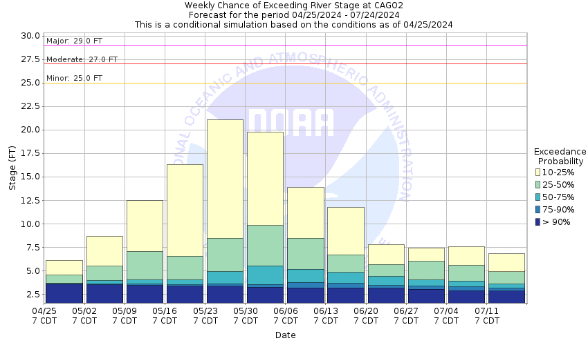
This probabilistic forecast is issued by the Arkansas Red-Basin River Forecast Center.
tab left off Hydrograph tab right off tab left off River at a Glance tab right off tab left off Download tab right off tab left on tab right on
About this graph
Forecasts for the Washita River near Carnegie are issued as needed during times of high water, but are not routinely available.
Return to Area Map

Upstream Gauge - near Clinton Upstream Gauge Downstream Gauge Downstream Gauge - at Anadarko
Zoom Level:16
Flood Categories (in feet)
Major Flood Stage: 29
Moderate Flood Stage: 27
Flood Stage: 25
Action Stage: 23
Low Stage (in feet): -9999

Historic Crests
(1) 31.70 ft on 10/20/1983
(2) 31.50 ft on 06/05/1995
(3) 31.21 ft on 05/18/1949
(4) 31.14 ft on 05/10/1993
(5) 30.81 ft on 08/19/2007
Show More Historic Crests

(P): Preliminary values subject to further review.

Recent Crests
(1) 16.07 ft on 06/10/2022 (P)
(2) 16.17 ft on 06/03/2022 (P)
(3) 14.01 ft on 06/27/2021
(4) 15.99 ft on 03/19/2020
(5) 29.87 ft on 05/27/2019
Show More Recent Crests

(P): Preliminary values subject to further review.

Low Water Records
Currently none available.
KML Image
Gauge LocationGauge Map Marker
Disclaimer
Latitude/Longitude Disclaimer: The gauge location shown in the above map is the approximate location based on the latitude/longitude coordinates provided to the NWS by the gauge owner.
Flood Impacts & Photos Collapse
If you notice any errors in the below information, please contact our Webmaster
33 Look for near-total flood plain coverage along the Washita River valley in eastern Washita and western Caddo counties. Some farm levees are overtopped several hours before the time of crest near Carnegie. More than sixty-five hundred acres of farm lands are covered by flood depths to about 8 feet... and will be the highest water levels since flood control began at Foss Dam. Local highways are blocked... isolating rural communities and many farmsteads.
32 Look for near-total flood plain coverage along the Washita River valley in eastern Washita and western Caddo counties. Some farm levees are overtopped several hours before the time of crest near Carnegie. Nearly sixty-five hundred acres of farm lands are covered by flood depths to about 7 feet... and will be the highest water levels since flood control began at Foss Dam. Local highways are blocked... isolating rural communities and many farmsteads.
31 Look for near-total flood plain coverage along the Washita River valley in eastern Washita and western Caddo counties. Some farm levees are overtopped several hours before the time of crest near Carnegie. About six thousand acres of farm lands are covered by flood depths to about 6 feet... and will be the highest water levels since flood control began at Foss Dam. Local highways are blocked... isolating rural communities and many farmsteads.
30 Look for wide flood plain coverage along the Washita River valley in eastern Washita and western Caddo counties. Some farm levees are overtopped hours before the time of crest near Carnegie. More than five thousand acres of farm lands are covered by flood depths to about 5 feet... and will be the highest water levels observed since flood control began at Foss Dam. local highways may be blocked... isolating some rural communities and many farmsteads.
29 Look for wide flood plain coverage along the Washita River valley in eastern Washita and western Caddo counties. Some farm levees are overtopped hours before the time of crest near Carnegie. More than four thousand acres of farm land are coveredby flood depths to about 4 feet. Local highways may be blocked... isolating some rural communities and many farmsteads.
28 Look for wide flooding along the Washita River valley in eastern Washita and western Caddo counties. Some farm levees are overtopped hours before the time of crest near Carnegie. About four thousand acres of farm land are covered by flood depths up to about 3 feet. Local highways may be blocked... isolating a few rural communities and farmsteads.
27 Look for flooding of croplands and pastures along the Washita River valley in eastern Washita and western Caddo counties. Some farm levees are overtopped hours before the time of crest near Carnegie. More than three thousand acres of farm land are covered by flood depths up to about 2 feet. Local roads may be overtopped... isolating a few farmsteads.
26 Flooding will cover nearly fifteen hundred acres of non-leveed farm lands along the Washita River valley in eastern Washita and western Caddo counties. Overflow depths average about a foot or more. Weaker portions of local levees may be breached. High water in cutoff channels and tributary streams will isolate some low-lying areas for several hours.
25 Shallow flooding will reach about a thousand acres of non-leveed farm lands along the Washita River valley in eastern Washita and western Caddo counties. Weaker portions of local levees may be overtopped. Deeper water in cutoff channels and tributary streams will isolate some low-lying fields for a few hours.
24 Near bankfull conditions occur along the Washita River in eastern Washita and western Caddo counties. High water in cutoff channels and tributary streams could isolate some low-lying fields for a few hours.
23 Near bankfull conditions occur along the Washita River in eastern Washita and western Caddo counties. High water in cutoff channels and tributary streams could isolate some low-lying fields for a few hours.

Other Real-time and/or Archive Data Sources:

Collaborative Agencies Collapse
The National Weather Service prepares its forecasts and other services in collaboration with agencies like the US Geological Survey, US Bureau of Reclamation, US Army Corps of Engineers, Natural Resource Conservation Service, National Park Service, ALERT Users Group, Bureau of Indian Affairs, and many state and local emergency managers across the country. For details, please click here.
NWS Information
National Weather Service
Norman Weather Forecast Office
National Weather Center
120 David L. Boren Blvd.
Suite 2400
Norman, OK 73072
(405) 325-3816
Ask Questions/Webmaster
Page last modified: 2-Nov-2020 7:29 PM
Disclaimer
Credits
Glossary
Privacy Policy
About Us
Career Opportunities