Skip Navigation Link weather.gov  
NOAA logo - Click to go to the NOAA homepage National Weather Service NWS logo - Click to go to the NWS homepage
Advanced Hydrologic Prediction Service
Image background of Navigation bar Left
Navigation Bar End Cap


This probabilistic forecast is issued by the Southeast River Forecast Center.
tab left off Hydrograph tab right off tab left off River at a Glance tab right off tab left off Download tab right off tab left off Inundation
Mapping
tab right off tab left on tab right on
About this graph
Forecasts for the Tar River at Louisburg are issued as needed during times of high water, but are not routinely available.

Vertical datum height surveyed by the USGS

Return to Area Map

Downstream Gauge Downstream Locations
Zoom Level:16
Flood Categories (in feet)
Major Flood Stage: 23
Moderate Flood Stage: 22
Flood Stage: 20
Action Stage: 20
Low Stage (in feet): -9999

Historic Crests
(1) 26.05 ft on 09/17/1999
(2) 25.34 ft on 09/07/1996
(3) 24.36 ft on 04/28/1978
(4) 23.25 ft on 10/10/2016
(5) 23.00 ft on 07/16/1975
Show More Historic Crests

(P): Preliminary values subject to further review.

Recent Crests
(1) 20.59 ft on 12/26/2020 (P)
(2) 22.03 ft on 11/14/2018
(3) 18.43 ft on 10/13/2018
(4) 20.98 ft on 09/19/2018
(5) 22.90 ft on 04/26/2017
Show More Recent Crests

(P): Preliminary values subject to further review.

Low Water Records
(1) 3.21 ft on 07/23/1986
(2) 3.45 ft on 09/20/1985
(3) 3.53 ft on 10/08/1986
(4) 3.69 ft on 10/11/1981
(5) 3.81 ft on 09/26/1980
Show More Low Water Records
KML Image
Gauge LocationGauge Map Marker
Disclaimer
Latitude/Longitude Disclaimer: The gauge location shown in the above map is the approximate location based on the latitude/longitude coordinates provided to the NWS by the gauge owner.
Flood Impacts & Photos Collapse
If you notice any errors in the below information, please contact our Webmaster
37 Water reaches the road surface of the US401 bridge.
34 South Main Street bridge is flooded to a depth of approximately 5 feet.
29 Water reaches the road level of the Main Street bridge. Flooding reaches businesses on Main and Nash Streets. The grounds of the Louisburg wastewater treatment plant (near the mouth of Fox swamp) is covered with water.
25 Significant flooding at businesses along Johnson, Court, Elm, and Short Streets.
23 Major flooding begins. Homes and businesses along Johnson Street flood.
22 Moderate flooding begins. Flooding begins in Pruitt and Shannon Villages on the east side of town.
20 Minor flooding begins. Banks overflow at Main Street. River Bend Park is flooded and storm drains are inundated along the river.
18 Bankfull in the vicinity of Main Street. Minor flooding begins in River Bend Park 0.1 miles upstream of Main Street.
Photos
(1) Main St. Bridge
(2) Louisburg Site
(3) LOUN7 Gage site about 0.2 miles downstream from the Main Street Bridge
(4) LOUN7 From the Main Street Bridge facing downstream towards the gage, which is about 0.2 miles downs

Other Real-time and/or Archive Data Sources:

Additional Information Collapse
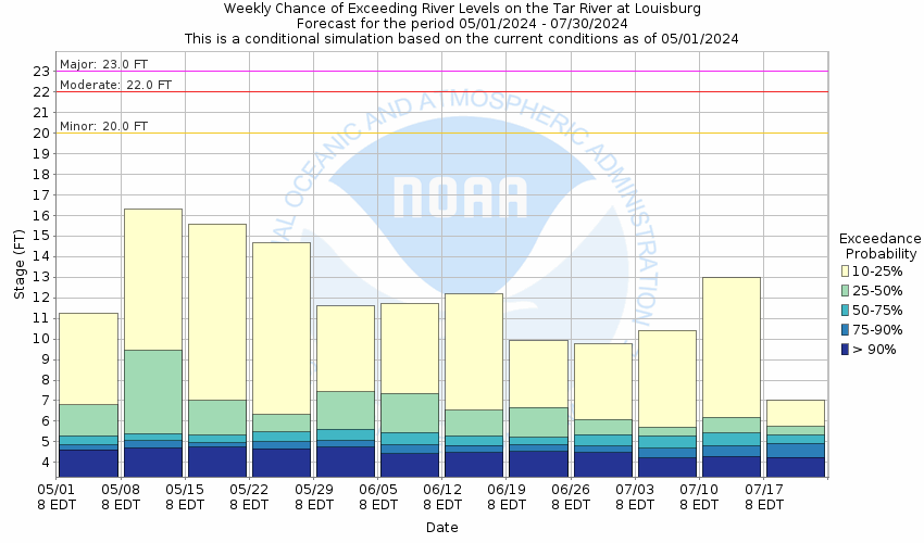
Potential River Levels - Used to
Potential River Levels
Used to Estimate the Chance of Flooding and the Range of Possible River Levels
10 day (HEFS) 7 Day (NAEFS) 7 Day (GEFS)
HEFS Ensemble NAEFS Ensemble GEFS Ensemble

Note: Use the official hydrograph at the top of this web page for river levels within the next 72 Hours.

Collaborative Agencies Collapse
The National Weather Service prepares its forecasts and other services in collaboration with agencies like the US Geological Survey, US Bureau of Reclamation, US Army Corps of Engineers, Natural Resource Conservation Service, National Park Service, ALERT Users Group, Bureau of Indian Affairs, and many state and local emergency managers across the country. For details, please click here.
NWS Information
National Weather Service
Raleigh Weather Forecast Office
1005 Capability Drive, Suite 300
Raleigh, NC 27606
(919) 326-1042
Ask Questions/Webmaster
Page last modified: 2-Nov-2020 7:30 PM
Disclaimer
Credits
Glossary
Privacy Policy
About Us
Career Opportunities