Skip Navigation Link weather.gov  
NOAA logo - Click to go to the NOAA homepage National Weather Service NWS logo - Click to go to the NWS homepage
Advanced Hydrologic Prediction Service
Image background of Navigation bar Left
Navigation Bar End Cap


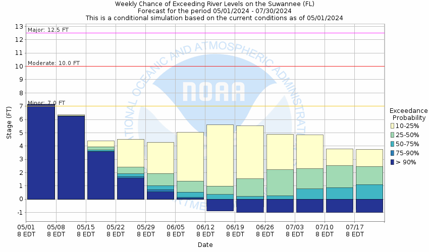
This probabilistic forecast is issued by the Southeast River Forecast Center.
tab left off Hydrograph tab right off tab left off River at a Glance tab right off tab left off Download tab right off tab left on tab right on
About this graph
Forecasts for the Suwannee River at Manatee Springs (in NAVD88) are issued as needed during times of high water, but are not routinely available.
Return to Area Map

Upstream Locations Upstream Gauge Downstream Gauge Downstream Gauge - at Fowlers Bluff (in NAVD88)
Zoom Level:14
Flood Categories (in feet)
Major Flood Stage: 12.5
Moderate Flood Stage: 10
Flood Stage: 7
Action Stage: 5
Low Stage (in feet): 0.2

Historic Crests
(1) 16.00 ft on 04/14/1948
(2) 13.00 ft on 04/21/1973
(3) 12.65 ft on 04/16/1984
(4) 11.00 ft on 01/28/1987
(5) 11.00 ft on 04/02/1959
Show More Historic Crests

(P): Preliminary values subject to further review.

Recent Crests
(1) 7.21 ft on 08/17/2021
(2) 8.10 ft on 01/05/2019
(3) 6.46 ft on 09/02/2016
(4) 8.82 ft on 03/26/2003
(5) 10.91 ft on 03/21/1991
Show More Recent Crests

(P): Preliminary values subject to further review.

Low Water Records
(1) 2.07 ft on 06/03/2003
(2) 2.26 ft on 07/26/2003
KML Image
Gauge LocationGauge Map Marker
Disclaimer
Latitude/Longitude Disclaimer: The gauge location shown in the above map is the approximate location based on the latitude/longitude coordinates provided to the NWS by the gauge owner.
Flood Impacts & Photos Collapse
If you notice any errors in the below information, please contact our Webmaster
16 Record flooding throughout the Lower Suwannee River Basin. In Dixie County, water begins to flood portions of SE Highway 349 near the entrances to New Pine Landing and Yellow Jacket. In Levy County, most residences between the river and NW 90th street are flooded. Several residences between NW 110th Avenue and NW 117th Avenue are flooded.
14 New Pine Landing flooding continues to drastically worsen. Most areas east of SE Highway 349 are flooded. Near Yellow Jacket, water approaches SE Highway 349. All structures and land areas in Yellow Jacket are flooded. In Levy County, flooding expands affecting numerous residences between the river at NW 90th street.
12.5 In Dixie County, catastrophic flooding in New Pine Landing. Access to areas nears the river is impossible. Yellow Jacket is isolated as SE 477 Avenue is flooded near Highway 349. Structures in the area experience considerable damage. In Levy County, water spreads into areas beyond NW 92nd Street to NW 90th Street. NW 102nd place floods in numerous locations. Flooding expands through Manatee Springs State Park. Water floods NW 129th Place, affecting access to homes nearer the river.
11 In Dixie County, significant flooding continues in New Pine Landing. Access into much of the area is impossible. Flooding expands to include portions of SW 295th Avenue near the river. Flooding expands in Yellow Jacket. Water begins to cross SE 477th Avenue near the entrance just east of Highway 349. In Levy County, water approaches homes on NW 92nd Street and on NW 93rd Lane. Water Begins to affect parking and RV areas at Manatee Springs State Park. Water nears some residences on NW 117th Avenue.
10 In Dixie County, significant flooding occurs in New Pine Landing. Structures not elevated experience considerable damage. Flooding worsens in Yellow Jacket with many areas flooding in the recreational area. Significatn damage occurs to non-elevated structures along the river in Yellow Jacket. In Levy County, flooding occurs near residences along NW 132nd Court and NW Camp Azalea Road. Water reaches the intersection of NW 130th Street and NW 117th Avenue.
9 In Dixie County, flooding worsens in New Pine Landing. SE 311st Avenue floods at this level. Access to homes on SE 851st street is impossible above this level. Flooding expands from the Yellow Jacket boat landing to include areas between SE 477th avenue and the river. In Levy County water begins to affect areas along NW 132nd court.
8 In Dixie County, flooding continues to expand at New Pine Landing. Most of SE 851st street is flooded and SE 837th street begins to flood. Water spreads out through the woods and approaches SE 311st avenue. Flooding worsens near Yellow Jacket with many areas east of SE 793rd street flooded. In Levy County, Minor flooding affects areas along the Manatee Spring run in the state Park.
7 In Dixie County, water floods portion of New Pine Landing along SE 851st street. Lancaster Landing floods. SE 477th Avenue in Yellow Jacket floods at this level.
Photos
(1) Suwannee River at Manatee Spring - KML

Other Real-time and/or Archive Data Sources:

Additional Information Collapse
HEFS Ensemble NAEFS Ensemble GEFS Ensemble
Collaborative Agencies Collapse
The National Weather Service prepares its forecasts and other services in collaboration with agencies like the US Geological Survey, US Bureau of Reclamation, US Army Corps of Engineers, Natural Resource Conservation Service, National Park Service, ALERT Users Group, Bureau of Indian Affairs, and many state and local emergency managers across the country. For details, please click here.
NWS Information
National Weather Service
Tallahassee Weather Forecast Office
Love Building FL State University
Tallahassee, FL 32306-4509
(850) 942-8833
Ask Questions/Webmaster
Page last modified: 2-Nov-2020 7:30 PM
Disclaimer
Credits
Glossary
Privacy Policy
About Us
Career Opportunities