Flood ImpactsIf you notice any errors in the below information, please contact our Webmaster
46.2
Flood of Record on August 14, 2016. At this level, widespread flooding will occur with most roads, including Interstate 12 and LA Hwy 190, inundated. Approximately 90 percent of the homes will be flooded, along with businesses and other buildings.
41.5
Widespread flooding of the area between Range Avenue in Denham Springs, west to Airline Highway in Baton Rouge, is expected. Significant flood reached this level in April 1983.
39
Widespread major flooding can be expected in subdivisions along Tiger Bend Road, Antioch Road, Eliot Road, and in Woodcrest and Stevendale Estates in Old Jefferson.
38.2
Tropical Storm Allison - June 2001
35
There will be moderate flooding of areas around Clay Cut Bayou, Jones Creek, and Honey Cut Bayou. In Denham Springs the area west of Florida Avenue will be subject to flooding.
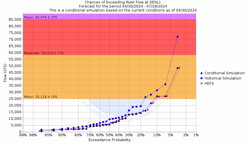
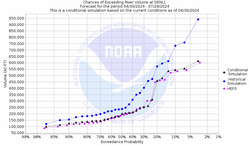
30
Flooding will begin in the westernmost parts of Denham Springs. River Road at the foot of Benton Lane will flood.
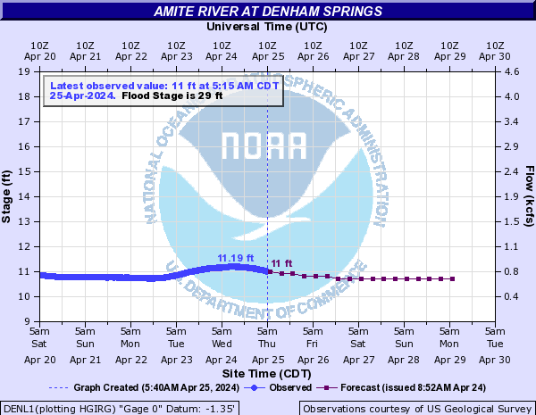
29
Flooding will begin in the westernmost parts of Denham Springs.
Flood Categories (in feet)
| Major Flood Stage: |
39 |
| Moderate Flood Stage: |
35 |
| Flood Stage: |
29 |
| Action Stage: |
26 |
| Low Stage (in feet): |
-9999 |
Historic Crests
(1) 46.20 ft on 08/14/2016
(2) 41.50 ft on 04/08/1983
(3) 41.08 ft on 04/23/1977
(4) 39.88 ft on 01/27/1990
(5) 39.27 ft on 03/15/1921
Show More Historic Crests
(P): Preliminary values subject to further review.
Recent Crests
(1) 29.35 ft on 01/27/2024
(2) 30.35 ft on 05/22/2021
(3) 31.47 ft on 04/17/2021
(4) 29.67 ft on 04/12/2021
(5) 31.37 ft on 02/13/2021
Show More Recent Crests
(P): Preliminary values subject to further review.
Low Water Records (1) 8.43 ft on 11/18/1938
(2) 9.30 ft on 10/31/2000
(3) 9.41 ft on 10/21/1972
(4) 9.65 ft on 10/08/1970
(5) 9.65 ft on 11/20/2023
Show More Low Water Records