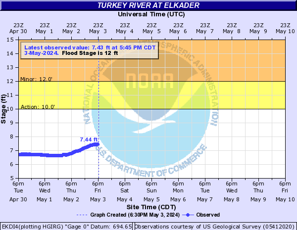
NOTE: River forecasts for this location take into account past precipitation and the precipitation amounts expected approximately 24 hours into the future from the forecast issuance time.
Flood Stage: 12 Feet
Latest Stage: 6.18
Current Warnings/Statements/Advisories:None currently.
Vertical Datum updated from NGVD29 to NAVD88 by gauge owner.
Flood ImpactsIf you notice any errors in the below information, please contact our Webmaster
12
Minor flooding occurs in areas near the river.
Flood Categories (in feet)
| Major Flood Stage: |
20 |
| Moderate Flood Stage: |
16 |
| Flood Stage: |
12 |
| Action Stage: |
10 |
| Low Stage (in feet): |
-9999 |
Historic Crests
(1) 27.77 ft on 06/10/2008
(2) 27.32 ft on 06/15/1991
(3) 25.57 ft on 05/23/2004
(4) 22.87 ft on 08/30/2021
(5) 22.57 ft on 08/26/2016
Show More Historic Crests
(P): Preliminary values subject to further review.
Recent Crests
(1) 13.77 ft on 02/27/2023
(2) 9.17 ft on 03/06/2022
(3) 22.87 ft on 08/30/2021
(4) 15.21 ft on 06/11/2020
(5) 12.23 ft on 05/20/2019
Show More Recent Crests
(P): Preliminary values subject to further review.
Low Water Records
Currently none available.
NOTE: River forecasts for this location take into account past precipitation and the precipitation amounts expected approximately 24 hours into the future from the forecast issuance time.
Flood Stage: 17 Feet
Latest Stage: 7.6
Current Warnings/Statements/Advisories:None currently.
Vertical Datum updated from NGVD29 to NAVD88 by gauge owner.
Flood ImpactsIf you notice any errors in the below information, please contact our Webmaster
31.5
The earthen levee at Elkport is overtopped.
26
The earthen levee at Elkport is threatened, just upstream of Garber.
19
County Road X3C at the south end of Garber becomes inundated.
17
Minor flooding begins in the communities of Garber, Osterdock, and Millville.
Flood Categories (in feet)
| Major Flood Stage: |
23 |
| Moderate Flood Stage: |
20 |
| Flood Stage: |
17 |
| Action Stage: |
14 |
| Low Stage (in feet): |
-9999 |
Historic Crests
(1) 32.80 ft on 05/23/2004
(2) 30.91 ft on 05/17/1999
(3) 30.10 ft on 06/15/1991
(4) 29.13 ft on 06/10/2008
(5) 28.06 ft on 02/23/1922
Show More Historic Crests
(P): Preliminary values subject to further review.
Recent Crests
(1) 18.35 ft on 02/27/2023
(2) 12.87 ft on 03/06/2022
(3) 23.39 ft on 08/30/2021
(4) 20.71 ft on 06/11/2020
(5) 20.24 ft on 10/02/2019
Show More Recent Crests
(P): Preliminary values subject to further review.
Low Water Records
(1) 4.80 ft on 01/28/1940
(2) 5.60 ft on 08/30/1989