Flood ImpactsIf you notice any errors in the below information, please contact our Webmaster
26
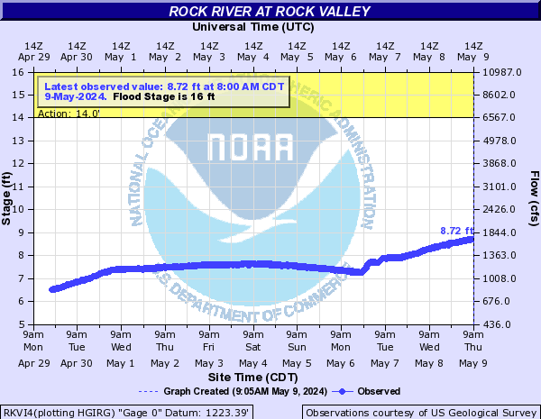
County Highway K30 north of Rock Valley is flooded.
22
the driveway and yard of the house near the gage are flooded.
20
major agricultural flooding begins throughout the flood plain.
19
Rock Valley begins to experience flood problems and sandbagging of storm sewers in the city begins.
16
significant amounts of agricultural lands are flooded, and some rural roads are also threatened by high water.
13
the lowest lying pasture and farm land will experience some minor flooding.
Flood Categories (in feet)
| Major Flood Stage: |
19 |
| Moderate Flood Stage: |
17 |
| Flood Stage: |
16 |
| Action Stage: |
14 |
| Low Stage (in feet): |
-9999 |
Historic Crests
(1) 22.72 ft on 06/17/2014
(2) 21.20 ft on 06/22/2018
(3) 20.61 ft on 03/15/2019
(4) 19.97 ft on 05/09/1993
(5) 19.89 ft on 09/25/2010
Show More Historic Crests
(P): Preliminary values subject to further review.
Recent Crests
(1) 11.25 ft on 04/13/2023
(2) 9.56 ft on 06/01/2022
(3) 6.72 ft on 04/10/2021
(4) 11.63 ft on 07/08/2020
(5) 20.61 ft on 03/15/2019
Show More Recent Crests
(P): Preliminary values subject to further review.
Low Water Records
Currently none available.