Flood ImpactsIf you notice any errors in the below information, please contact our Webmaster
20.5
Water overtops the floodwall at the water treatment plant...located at 13th St NE.
17.4
Water reaches bottom of railroad bridge east of Kentucky Avenue bridge.
15
This is the approximate top of levee protection. Levees run from the 12th Street Northeast bridge to 9th Street along the east bank and also from 8th Street to 6th and Hampshire Streets.
14
Water may flow over the city dikes.
12
Widespread flooding occurs along the river. Some backwater effects are possible along Willow Creek between downtown Mason City and the confluence with the Winnebago river.
11
Sandbagging occurs on the dike from 12th Street Northeast to Carolina Street.
10
There is widespread flooding of city parks and water reaches the underside of the 12th Street Northeast bridge at the piers.
8
East and west city parks are affected in the 12th Street Northeast area.
7
Low lying areas along the river are affected.
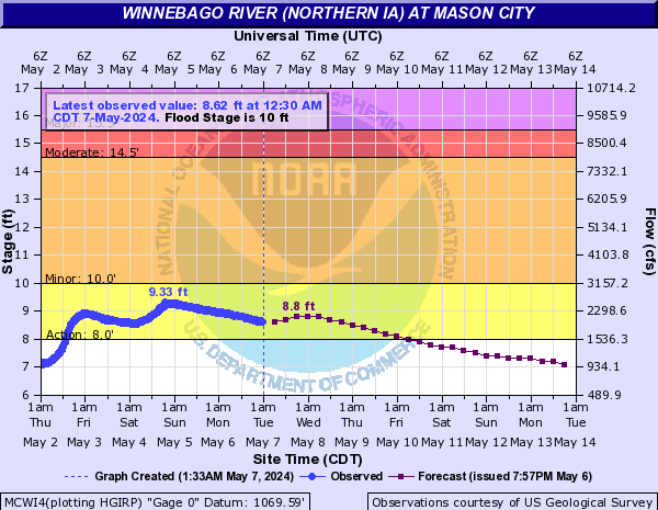
Flood Categories (in feet)
| Major Flood Stage: |
15.5 |
| Moderate Flood Stage: |
14.5 |
| Flood Stage: |
10 |
| Action Stage: |
8 |
| Low Stage (in feet): |
-9999 |
Historic Crests
(1) 18.74 ft on 06/08/2008
(2) 15.70 ft on 03/30/1933
(3) 14.80 ft on 03/27/1961
(4) 14.67 ft on 05/22/2004
(5) 14.27 ft on 04/11/1965
(6) 14.07 ft on 09/22/2016
(7) 13.06 ft on 08/31/1962
(8) 12.59 ft on 04/01/1993
(9) 12.44 ft on 04/07/1951
(10) 12.25 ft on 07/08/1969
Show More Historic Crests
(P): Preliminary values subject to further review.
Recent Crests
(1) 11.24 ft on 02/27/2023
(2) 10.91 ft on 04/13/2022
(3) 5.78 ft on 08/28/2021
(4) 7.34 ft on 03/05/2020
(5) 7.27 ft on 10/06/2019
(6) 10.42 ft on 03/20/2019
(7) 10.54 ft on 03/17/2019
(8) 12.17 ft on 09/21/2018
(9) 7.14 ft on 02/21/2017
(10) 14.07 ft on 09/22/2016
Show More Recent Crests
(P): Preliminary values subject to further review.
Low Water Records
Currently none available.