NOTE:
Forecasts are not available for the North Raccoon River near Sac City. Only observed stages are available for this point.
Flood Impacts
9999.9
** NOTE ** If you notice any errors in the below information please contact our Webmaster at w-dmx.webmaster@noaa.gov .
Flood Categories (in feet)
Major Flood Stage:
0
Moderate Flood Stage:
0
Flood Stage:
13
Action Stage:
12
Historical Crests (1) 20.14 ft on 06/17/1990 (2) 19.41 ft on 06/09/2008 (3) 19.03 ft on 06/26/2005 (4) 18.38 ft on 07/10/2003 (5) 18.12 ft on 09/01/1962 (6) 18.04 ft on 05/07/2007 (7) 18.02 ft on 03/23/1979 (8) 17.65 ft on 06/21/1996 (9) 17.55 ft on 07/11/1993 (10) 17.32 ft on 06/28/2011 Show More Historical Crests
NOTE:
Forecasts are not available for the North Raccoon River near Lanesboro. Only observed stages are available for this point.
Flood Impacts
9999.9
** NOTE ** If you notice any errors in the below information please contact our Webmaster at w-dmx.webmaster@noaa.gov .
Flood Categories (in feet)
Major Flood Stage:
0
Moderate Flood Stage:
0
Flood Stage:
15
Action Stage:
12
Historical Crests (1) 20.46 ft on 06/23/1996 (2) 18.50 ft on 07/11/2003 (3) 18.21 ft on 06/25/1998 (4) 17.51 ft on 08/24/2007 (5) 16.90 ft on 04/24/1999 (6) 15.17 ft on 05/29/1995 (7) 14.17 ft on 08/24/2002 (8) 13.58 ft on 04/07/1997 (9) 10.87 ft on 08/20/2000
NOTE:
Forecasts for the North Raccoon River near Jefferson are issued as needed during times of high water, but are not routinely available.
Flood Impacts
9999.9
** NOTE ** If you notice any errors in the below information please contact our Webmaster at w-dmx.webmaster@noaa.gov .
21
Water affects buildings at the Raccoon River Bible Camp north of Scranton. Residences along the river may experience flooding.
20
Water affects the Raccoon River Bible Camp north of Scranton. 3500 acres of agricultural land floods in Greene County.
19
Water affects the low areas of the Raccoon River Bible Camp north of Scranton. Water affects yards of residences along the river.
Flood Categories (in feet)
Major Flood Stage:
23
Moderate Flood Stage:
21
Flood Stage:
19
Action Stage:
17
Historical Crests (1) 22.30 ft on 06/23/1947 (2) 19.52 ft on 06/22/1954 (3) 19.43 ft on 03/31/1960 (4) 19.20 ft on 07/10/1993 (5) 18.61 ft on 06/19/1990 (6) 18.41 ft on 06/09/2008 (7) 18.16 ft on 03/18/2010 (8) 17.94 ft on 02/12/2009 (9) 17.86 ft on 06/21/1984 (10) 17.84 ft on 03/25/1979 Show More Historical Crests
NOTE:
Forecasts for the North Raccoon River near Perry are issued as needed during times of high water, but are not routinely available.
Flood Impacts
9999.9
** NOTE ** If you notice any errors in the below information please contact our Webmaster at w-dmx.webmaster@noaa.gov .
21.6
Water covers a 2 block area of Grove Street in Adel east of US 169. Water is 2 to 3 feet deep over the south entrance to the Dallas county fairgrounds off of US 169. Water covers businesses north of Adel on west side of US 169. The entrance to Island Park campground and soccer complex in Adel is covered.
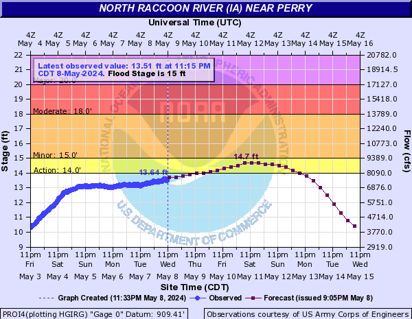
20
Limited evacuations may begin in residential areas of Adel...along with extensive sandbagging.
19
Approaches to the US 169 bridge over the river north of Adel are impassable.
18
Parts of US 169 north of Adel are overtopped. Many rural roads are affected.
17
Water approaches the bottom of the US 169 bridge on the north side of Adel. Farmland northeast of Adel floods.
16.5
125th Trail north of Dawson and west of Highway P46 is affected.
16
180th Lane west of Minburn is affected by flood waters.
15
In Perry...farmland floods and the waste water treatment facility is affected. Near Adel...the fairgrounds and golf course are affected. Northwest of Adel...Sportsman Club Road and Midland Trail flood.
13
Water affects agricultural land.
Flood Categories (in feet)
Major Flood Stage:
20
Moderate Flood Stage:
18
Flood Stage:
15
Action Stage:
14
Historical Crests (1) 23.00 ft on 07/10/1993 (2) 22.70 ft on 03/20/1979 (3) 21.67 ft on 06/10/2008 (4) 20.29 ft on 04/27/2007 (5) 20.00 ft on 06/19/1990 (6) 18.78 ft on 07/12/2003 (7) 18.60 ft on 06/07/1991 (8) 18.50 ft on 07/03/1983 (9) 18.00 ft on 06/22/1984 (10) 17.92 ft on 05/04/2001 Show More Historical Crests
The National Weather Service prepares its forecasts and other services in collaboration with agencies like the US Geological Survey, US Bureau of Reclamation, US Army Corps of Engineers, Natural Resource Conservation Service, National Park Service, ALERT Users Group, Bureau of Indian Affairs, and many state and local emergency managers across the country. For details, please click here.
NWS Information
National Weather Service
Des Moines Weather Forecast Office
9607 NW Beaver Dr.
Des Moines, IA 50131
(515) 270-2614 Ask Questions/Webmaster
Page last modified: 3-Aug-2012 12:12 AM