Little Sioux River Above Spencer (LSSI4)
Return to TopNOTE: River forecasts for this location take into account past precipitation and the precipitation amounts expected approximately 48 hours into the future from the forecast issuance time.
Flood Stage: 0 KCFS
Latest Flow: n/a
NOTE:Forecasts are not available for the Little Sioux River above Spencer. Only observed stages are available for this point.
Flood Categories (in feet)
| Major Flood Stage: |
15 |
| Moderate Flood Stage: |
13 |
| Flood Stage: |
10 |
| Action Stage: |
9 |
| Low Stage (in feet): |
-9999 |
Historic Crests
(1) 14.45 ft on 07/15/2011
(2) 13.49 ft on 06/20/2014
(3) 13.20 ft on 03/18/2010
(4) 10.99 ft on 03/10/2013
(5) 9.95 ft on 06/01/2012
(P): Preliminary values subject to further review.
Recent Crests
(1) 13.49 ft on 06/20/2014
(2) 10.99 ft on 03/10/2013
(3) 9.95 ft on 06/01/2012
(4) 14.45 ft on 07/15/2011
(5) 13.20 ft on 03/18/2010
(P): Preliminary values subject to further review.
Low Water Records
Currently none available.
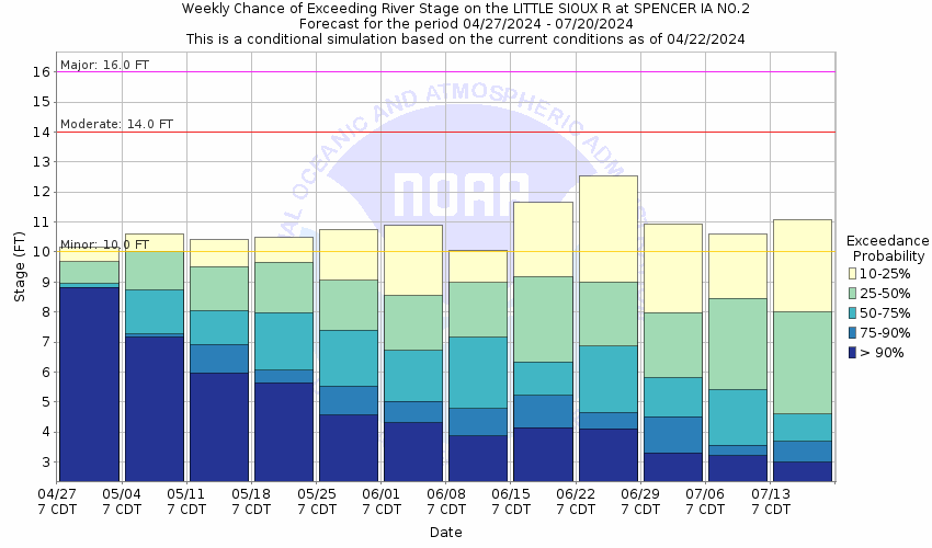
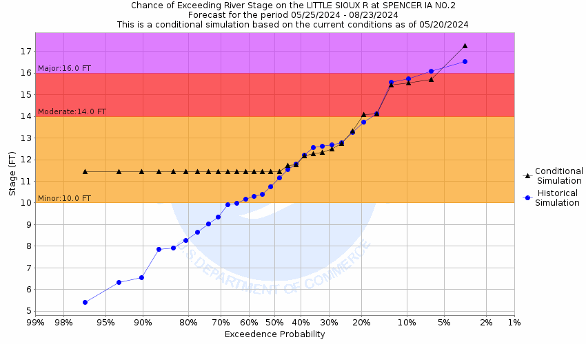
Little Sioux River At Spencer (SPWI4)
Return to TopNOTE: River forecasts for this location take into account past precipitation and the precipitation amounts expected approximately 48 hours into the future from the forecast issuance time.
Flood Stage: 10 Feet
Latest Stage: 13.18
NOTE:Forecasts for the Little Sioux River at Spencer are issued as needed during times of high water, but are not routinely available.
Flood Categories (in feet)
| Major Flood Stage: |
16 |
| Moderate Flood Stage: |
14 |
| Flood Stage: |
10 |
| Action Stage: |
9 |
| Low Stage (in feet): |
-9999 |
Historic Crests
(1) 20.20 ft on 06/08/1953
(2) 17.60 ft on 06/21/1954
(3) 17.45 ft on 03/15/2019
(4) 17.40 ft on 06/26/2018
(5) 17.37 ft on 04/06/1965
Show More Historic Crests
(P): Preliminary values subject to further review.
Recent Crests
(1) 10.89 ft on 05/16/2023
(2) 11.70 ft on 03/10/2020
(3) 17.45 ft on 03/15/2019
(4) 17.40 ft on 06/26/2018
(5) 12.20 ft on 05/23/2017
Show More Recent Crests
(P): Preliminary values subject to further review.
Low Water Records
Currently none available.
Probabilistic Stage Forecast for Spencer
Stage Exceedance Forecast for Spencer
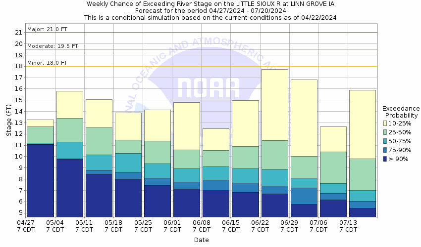
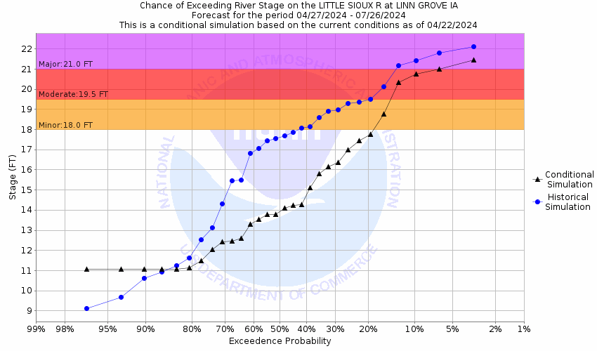
Little Sioux River At Linn Grove (LNNI4)
Return to TopNOTE: River forecasts for this location take into account past precipitation and the precipitation amounts expected approximately 48 hours into the future from the forecast issuance time.
Flood Stage: 18 Feet
Latest Stage: 17.92
NOTE:Forecasts for the Little Sioux River at Linn Grove are issued as needed during times of high water, but are not routinely available.
Flood Categories (in feet)
| Major Flood Stage: |
21 |
| Moderate Flood Stage: |
19.5 |
| Flood Stage: |
18 |
| Action Stage: |
17 |
| Low Stage (in feet): |
-9999 |
Historic Crests
(1) 24.13 ft on 03/16/2019
(2) 23.91 ft on 09/22/2018
(3) 22.91 ft on 06/18/2014
(4) 22.85 ft on 03/17/2010
(5) 22.57 ft on 07/17/2011
Show More Historic Crests
(P): Preliminary values subject to further review.
Recent Crests
(1) 13.90 ft on 05/18/2023
(2) 7.76 ft on 03/09/2021
(3) 15.72 ft on 05/29/2020
(4) 24.13 ft on 03/16/2019
(5) 23.91 ft on 09/22/2018
Show More Recent Crests
(P): Preliminary values subject to further review.
Low Water Records
Currently none available.
Probabilistic Stage Forecast for Linn Grove
Stage Exceedance Forecast for Linn Grove
Little Sioux River At Cherokee (CHKI4)
Return to TopNOTE: River forecasts for this location take into account past precipitation and the precipitation amounts expected approximately 48 hours into the future from the forecast issuance time.
Flood Stage: 17 Feet
Latest Stage: 20.32
NOTE:Forecasts for the Little Sioux River at Cherokee are issued as needed during times of high water, but are not routinely available.
Flood Categories (in feet)
| Major Flood Stage: |
24 |
| Moderate Flood Stage: |
21 |
| Flood Stage: |
17 |
| Action Stage: |
15 |
| Low Stage (in feet): |
-9999 |
Historic Crests
(1) 28.40 ft on 03/14/2019
(2) 27.90 ft on 05/27/2013
(3) 27.30 ft on 06/27/2010
(4) 27.20 ft on 04/07/1965
(5) 27.08 ft on 07/18/1993
Show More Historic Crests
(P): Preliminary values subject to further review.
Recent Crests
(1) 12.71 ft on 05/18/2023
(2) 16.38 ft on 05/28/2020
(3) 28.40 ft on 03/14/2019
(4) 27.00 ft on 09/21/2018
(5) 19.83 ft on 05/04/2016
Show More Recent Crests
(P): Preliminary values subject to further review.
Low Water Records
Currently none available.
Probabilistic Stage Forecast for Cherokee
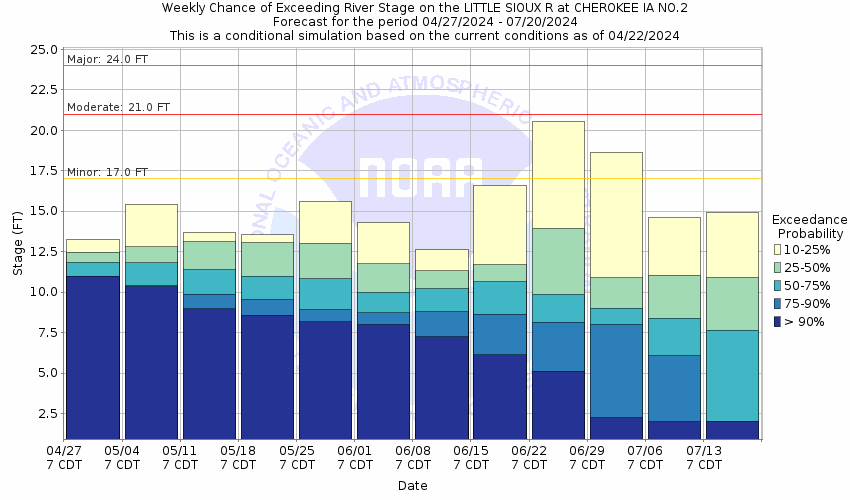
Stage Exceedance Forecast for Cherokee

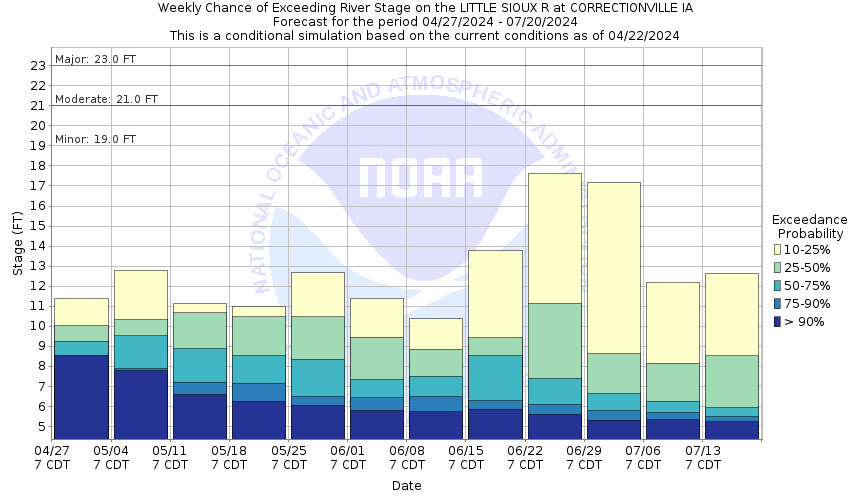
Little Sioux River At Correctionville (CRRI4)
Return to TopNOTE: River forecasts for this location take into account past precipitation and the precipitation amounts expected approximately 48 hours into the future from the forecast issuance time.
Flood Stage: 19 Feet
Latest Stage: 18.14
Current Warnings/Statements/Advisories:None currently.
NOTE:Forecasts for the Little Sioux River at Correctionville are issued as needed during times of high water, but are not routinely available.
Flood Categories (in feet)
| Major Flood Stage: |
23 |
| Moderate Flood Stage: |
21 |
| Flood Stage: |
19 |
| Action Stage: |
17 |
| Low Stage (in feet): |
-9999 |
Historic Crests
(1) 29.34 ft on 06/23/1891
(2) 26.45 ft on 03/15/2019
(3) 25.86 ft on 04/07/1965
(4) 25.35 ft on 05/28/2013
(5) 24.39 ft on 06/20/2014
Show More Historic Crests
(P): Preliminary values subject to further review.
Recent Crests
(1) 12.91 ft on 02/28/2023
(2) 13.64 ft on 05/28/2020
(3) 26.45 ft on 03/15/2019
(4) 24.30 ft on 09/24/2018
(5) 13.66 ft on 05/27/2017
Show More Recent Crests
(P): Preliminary values subject to further review.
Low Water Records
Currently none available.
Probabilistic Stage Forecast for Correctionville
Stage Exceedance Forecast for Correctionville

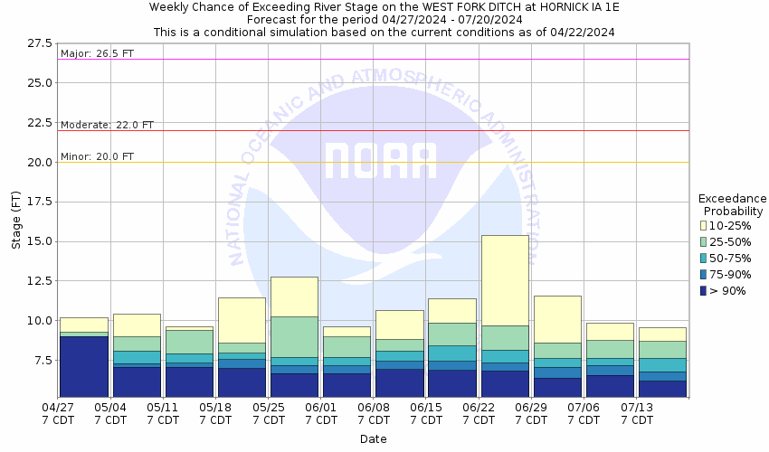
West Fork Ditch Near Hornick (HOKI4)
Return to TopNOTE: River forecasts for this location take into account past precipitation and the precipitation amounts expected approximately 48 hours into the future from the forecast issuance time.
Flood Stage: 20 Feet
Latest Stage: 9.66
Current Warnings/Statements/Advisories:None currently.
NOTE:Forecasts for the West Fork Ditch near Hornick are issued as needed during times of high water, but are not routinely available.
Flood Categories (in feet)
| Major Flood Stage: |
26.5 |
| Moderate Flood Stage: |
22 |
| Flood Stage: |
20 |
| Action Stage: |
18 |
| Low Stage (in feet): |
-9999 |
Historic Crests
(1) 26.52 ft on 03/14/2019
(2) 25.87 ft on 06/22/1996
(3) 25.20 ft on 03/30/1960
(4) 23.70 ft on 08/18/2015
(5) 23.59 ft on 06/17/2014
Show More Historic Crests
(P): Preliminary values subject to further review.
Recent Crests
(1) 18.74 ft on 02/27/2023
(2) 7.82 ft on 03/25/2021
(3) 13.77 ft on 12/29/2019
(4) 26.52 ft on 03/14/2019
(5) 0.00 ft on 02/12/2017
Show More Recent Crests
(P): Preliminary values subject to further review.
Low Water Records
Currently none available.
Probabilistic Stage Forecast for Hornick
Stage Exceedance Forecast for Hornick

Little Sioux River Near Turin (TURI4)
Return to TopNOTE: River forecasts for this location take into account past precipitation and the precipitation amounts expected approximately 24 hours into the future from the forecast issuance time.
Flood Stage: 25 Feet
Latest Stage: 18.96
Current Warnings/Statements/Advisories:None currently.
NOTE:Forecasts for the Little Sioux River near Turin are issued as needed during times of high water, but are not routinely available.
Flood Categories (in feet)
| Major Flood Stage: |
34.5 |
| Moderate Flood Stage: |
28 |
| Flood Stage: |
25 |
| Action Stage: |
22 |
| Low Stage (in feet): |
-9999 |
Historic Crests
(1) 29.57 ft on 03/15/2019
(2) 27.44 ft on 02/19/1971
(3) 26.99 ft on 06/22/1996
(4) 26.54 ft on 06/21/1983
(5) 26.47 ft on 03/19/1978
Show More Historic Crests
(P): Preliminary values subject to further review.
Recent Crests
(1) 10.25 ft on 06/05/2022
(2) 9.07 ft on 03/04/2021
(3) 16.02 ft on 02/24/2020
(4) 29.57 ft on 03/15/2019
(5) 23.86 ft on 09/25/2018
Show More Recent Crests
(P): Preliminary values subject to further review.
Low Water Records
Currently none available.
Probabilistic Stage Forecast for Turin

Stage Exceedance Forecast for Turin


