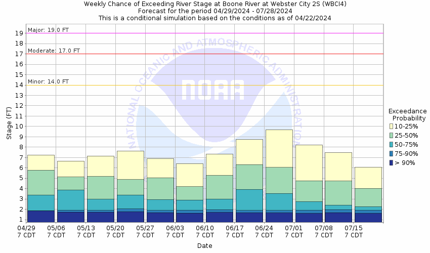
Flood Categories (in feet)
| Major Flood Stage: |
19 |
| Moderate Flood Stage: |
17 |
| Flood Stage: |
14 |
| Action Stage: |
9 |
| Low Stage (in feet): |
-9999 |
Historic Crests
(1) 19.10 ft on 06/10/1918
(2) 18.55 ft on 06/22/1954
(3) 18.17 ft on 06/28/2010
(4) 17.74 ft on 06/10/2008
(5) 16.00 ft on 06/18/1932
(6) 15.91 ft on 04/06/1965
(7) 15.63 ft on 06/05/1991
(8) 15.55 ft on 05/25/2004
(9) 15.32 ft on 04/01/1993
(10) 14.40 ft on 09/23/2018
Show More Historic Crests
(P): Preliminary values subject to further review.
Recent Crests
(1) 8.44 ft on 02/27/2023
(2) 6.04 ft on 06/17/2022
(3) 4.37 ft on 05/23/2021
(4) 8.91 ft on 10/10/2019
(5) 11.36 ft on 03/18/2019
(6) 11.49 ft on 03/15/2019
(7) 14.40 ft on 09/23/2018
(8) 7.05 ft on 05/21/2017
(9) 7.30 ft on 01/21/2017
(10) 14.03 ft on 09/25/2016
Show More Recent Crests
(P): Preliminary values subject to further review.
Low Water Records
Currently none available.