Flood ImpactsIf you notice any errors in the below information, please contact our Webmaster
26.3
Water impacts I-35 south of US 30.
26
The US 30 bridge over the South Skunk River is overtopped. Widespread flooding also occurs along Dayton Avenue.
25.5
Widespread flooding of US 30 occurs.
25
I-35 south of US 30...as well as US 30 between Dayton and Duff Avenues...flood. Hotels and industries along Dayton Avenue flood as well.
24
US 30 floods between Dayton and Duff Avenues. Basements also flood in Cambridge. Hotels on Southeast 16th Street have water in their parking lots. SE 16th may be closed due to water over the road.
23
The Shady Grove Trailer Park...located at 1006 South Dayton Avenue...floods. The railroad just northeast of Cambridge floods as well.
21
Water affects South 16th Street. Water also affects the sports complex along the river south of US 30.
20.5
Gravel roads just upstream from US 30 flood. Agricultural flooding also occurs from Ames downstream to northeast Polk County.
20
Water affects agricultural land from Ames to Cambridge.
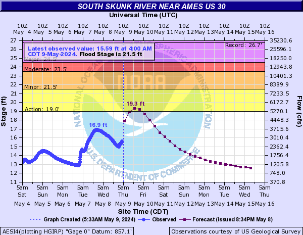
Flood Categories (in feet)
| Major Flood Stage: |
24.5 |
| Moderate Flood Stage: |
23.5 |
| Flood Stage: |
21.5 |
| Action Stage: |
19 |
| Low Stage (in feet): |
-9999 |
Historic Crests
(1) 26.72 ft on 08/11/2010
(2) 25.57 ft on 06/27/1975
(3) 25.53 ft on 07/09/1993
(4) 25.40 ft on 06/17/1990
(5) 25.13 ft on 06/17/1996
(6) 24.70 ft on 05/30/2008
(7) 23.98 ft on 08/30/2015
(8) 23.79 ft on 07/01/2014
(9) 23.68 ft on 03/19/1979
(10) 23.20 ft on 04/26/2007
Show More Historic Crests
(P): Preliminary values subject to further review.
Recent Crests
(1) 19.53 ft on 02/27/2023
(2) 22.10 ft on 06/15/2022
(3) 12.46 ft on 03/05/2021
(4) 17.89 ft on 05/27/2020
(5) 23.09 ft on 03/14/2019
(6) 22.77 ft on 06/15/2018
(7) 16.95 ft on 05/01/2017
(8) 18.19 ft on 01/21/2017
(9) 22.84 ft on 12/15/2015
(10) 23.98 ft on 08/30/2015
Show More Recent Crests
(P): Preliminary values subject to further review.
Low Water Records
Currently none available.