Flood ImpactsIf you notice any errors in the below information, please contact our Webmaster
25
Much of Highway 48 east of the bridge is flooded and the remaining levees in Akron are overtopped.
23.25
Levee gates at Riverside in Sioux City will be closed.
23
The higher levees on the Iowa side of the river are in danger of being overtopped, Highway 50 near Westfield will be flooded, and the bridge east of Jefferson will be overtopped.
22
Highway 48 begins to flood where the railroad tracks cross, and Iowa Highway 3 begins to flood on the east side of the river.
21.5
Highway 48 near the intersection with Iowa Highway 12 north of Akron begins to flood.
20
Highway 48 near Akron is flooded and the parking lot at the boat ramp in Akron begins to flood.
19.5
Several farm houses are flooded.
17
About 6500 acres of farm land are flooded.
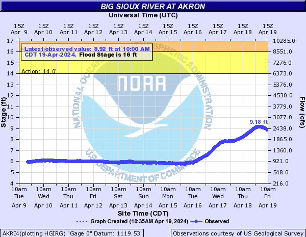
16
Several farm levees are overtopped with significant flooding of agricultural lands.
15
Some rural roads on the South Dakota side of the river begin to flood.
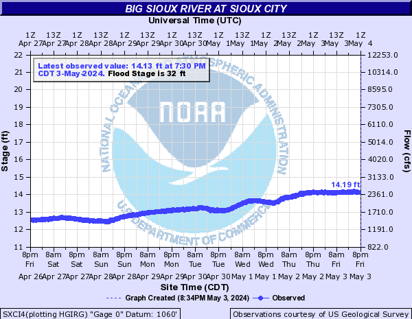
12
Some very minor flooding of the lowest lying areas along the river begins.
Flood Categories (in feet)
| Major Flood Stage: |
20 |
| Moderate Flood Stage: |
18 |
| Flood Stage: |
16 |
| Action Stage: |
14 |
| Low Stage (in feet): |
-9999 |
Historic Crests
(1) 25.46 ft on 06/18/2014
(2) 23.94 ft on 03/16/2019
(3) 23.45 ft on 06/23/2018
(4) 23.38 ft on 04/26/2001
(5) 23.05 ft on 05/10/1993
Show More Historic Crests
(P): Preliminary values subject to further review.
Recent Crests
(1) 17.97 ft on 04/14/2023
(2) 14.03 ft on 06/01/2022
(3) 11.45 ft on 08/30/2021
(4) 17.67 ft on 04/01/2020
(5) 23.94 ft on 03/16/2019
Show More Recent Crests
(P): Preliminary values subject to further review.
Low Water Records
Currently none available.