Mississippi River Below Lock and Dam 8 - Genoa (GENW3)
Return to TopNOTE: River forecasts for this location take into account past precipitation and the precipitation amounts expected approximately 24 hours into the future from the forecast issuance time.
Flood Stage: 631 Feet
Latest Stage: 625.42
Vertical Datum is the USACE 1912 datum
NOTE:Forecasts for the Mississippi River below Lock and Dam 8 - Genoa are issued routinely during the navigation season, and as needed at other times of the year.
Vertical Datum is the USACE 1912 datum
Flood Categories (in feet)
| Major Flood Stage: |
636 |
| Moderate Flood Stage: |
634 |
| Flood Stage: |
631 |
| Action Stage: |
625.2 |
| Low Stage (in feet): |
-9999 |
Historic Crests
(1) 638.40 ft on 04/22/1965
(2) 636.45 ft on 04/12/1997
(3) 636.21 ft on 04/18/2001
(4) 635.72 ft on 04/27/2023
(P)
(5) 635.24 ft on 04/20/1969
Show More Historic Crests
(P): Preliminary values subject to further review.
Recent Crests
(1) 635.72 ft on 04/27/2023
(P)
(2) 631.97 ft on 05/25/2019
(3) 631.00 ft on 05/07/2019
(4) 633.84 ft on 04/04/2019
(5) 631.74 ft on 03/28/2019
Show More Recent Crests
(P): Preliminary values subject to further review.
Probabilistic Stage Forecast for Lock and Dam 8 - Genoa
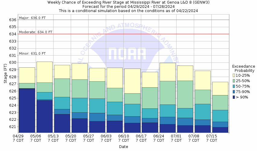
Stage Exceedance Forecast for Lock and Dam 8 - Genoa

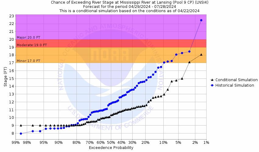
Mississippi River At Lansing - Pool 9 (LNSI4)
Return to TopNOTE: River forecasts for this location take into account past precipitation and the precipitation amounts expected approximately 24 hours into the future from the forecast issuance time.
Flood Stage: 17 Feet
Latest Stage: 8.87
Vertical Datum is the USACE 1912 datum
NOTE:Forecasts for the Mississippi River at Lansing - Pool 9 are issued routinely during the navigation season, and as needed at other times of the year.
Vertical Datum is the USACE 1912 datum
Flood Categories (in feet)
| Major Flood Stage: |
20 |
| Moderate Flood Stage: |
19 |
| Flood Stage: |
17 |
| Action Stage: |
12 |
| Low Stage (in feet): |
-9999 |
Historic Crests
(1) 22.50 ft on 04/24/1965
(2) 19.93 ft on 04/21/2001
(3) 19.90 ft on 06/20/1880
(4) 19.61 ft on 04/28/2023
(P)
(5) 18.88 ft on 04/22/1969
Show More Historic Crests
(P): Preliminary values subject to further review.
Recent Crests
(1) 19.61 ft on 04/28/2023
(P)
(2) 17.03 ft on 05/01/2019
(3) 17.83 ft on 04/26/2019
(4) 17.89 ft on 04/04/2019
(5) 17.61 ft on 04/18/2011
Show More Recent Crests
(P): Preliminary values subject to further review.
Probabilistic Stage Forecast for Lansing - Pool 9

Stage Exceedance Forecast for Lansing - Pool 9
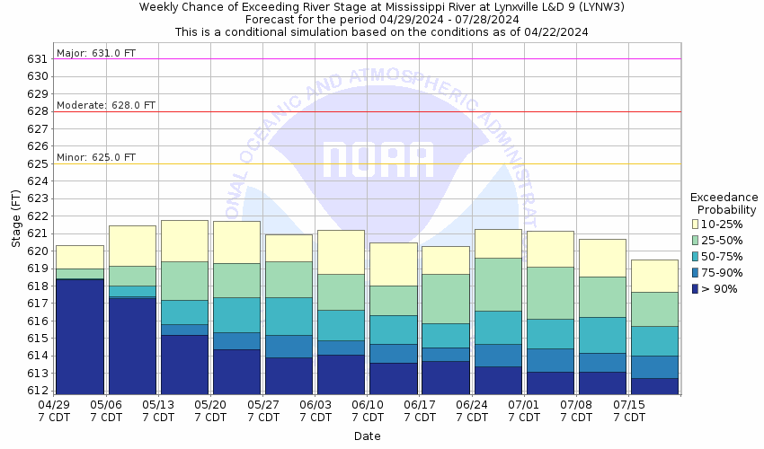
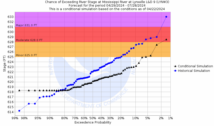
Mississippi River Below Lock and Dam 9 - Lynxville (LYNW3)
Return to TopNOTE: River forecasts for this location take into account past precipitation and the precipitation amounts expected approximately 24 hours into the future from the forecast issuance time.
Flood Stage: 625 Feet
Latest Stage: 617.71
Vertical Datum is the USACE 1912 datum
NOTE:Forecasts for the Mississippi River below Lock and Dam 9 - Lynxville are issued routinely during the navigation season, and as needed at other times of the year.
Vertical Datum is the USACE 1912 datum
Flood Categories (in feet)
| Major Flood Stage: |
631 |
| Moderate Flood Stage: |
628 |
| Flood Stage: |
625 |
| Action Stage: |
619 |
| Low Stage (in feet): |
-9999 |
Historic Crests
(1) 633.16 ft on 04/24/1965
(2) 631.22 ft on 04/21/2001
(3) 631.05 ft on 04/14/1997
(4) 630.26 ft on 04/28/2023
(P)
(5) 629.42 ft on 04/22/1969
Show More Historic Crests
(P): Preliminary values subject to further review.
Recent Crests
(1) 630.26 ft on 04/28/2023
(P)
(2) 626.39 ft on 06/02/2019
(3) 628.74 ft on 04/26/2019
(4) 628.37 ft on 04/17/2011
(5) 626.33 ft on 10/02/2010
Show More Recent Crests
(P): Preliminary values subject to further review.
Probabilistic Stage Forecast for Lock and Dam 9 - Lynxville
Stage Exceedance Forecast for Lock and Dam 9 - Lynxville
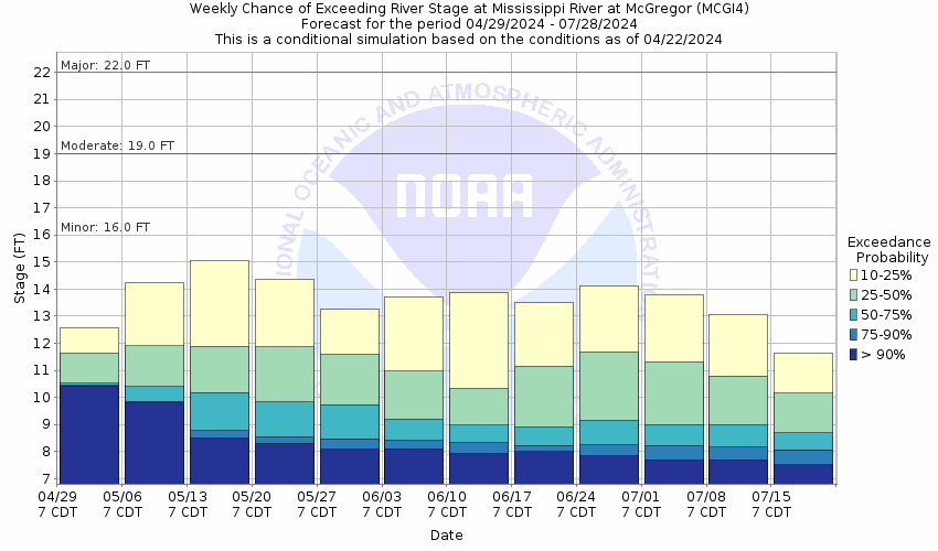
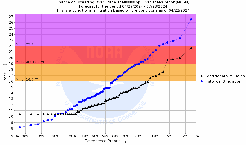
Mississippi River At McGregor (MCGI4)
Return to TopNOTE: River forecasts for this location take into account past precipitation and the precipitation amounts expected approximately 24 hours into the future from the forecast issuance time.
Flood Stage: 16 Feet
Latest Stage: 10.33
NOTE:Forecasts for the Mississippi River at McGregor are issued routinely during the navigation season, and as needed at other times of the year.
Flood Categories (in feet)
| Major Flood Stage: |
22 |
| Moderate Flood Stage: |
19 |
| Flood Stage: |
16 |
| Action Stage: |
13 |
| Low Stage (in feet): |
-9999 |
Historic Crests
(1) 25.38 ft on 04/24/1965
(2) 23.75 ft on 04/20/2001
(3) 22.91 ft on 04/28/2023
(P)
(4) 21.98 ft on 06/29/1993
(5) 21.75 ft on 04/26/2019
Show More Historic Crests
(P): Preliminary values subject to further review.
Recent Crests
(1) 22.91 ft on 04/28/2023
(P)
(2) 16.77 ft on 10/12/2019
(P)
(3) 19.09 ft on 06/02/2019
(4) 21.75 ft on 04/26/2019
(5) 16.87 ft on 09/29/2016
Show More Recent Crests
(P): Preliminary values subject to further review.
Probabilistic Stage Forecast for McGregor
Stage Exceedance Forecast for McGregor
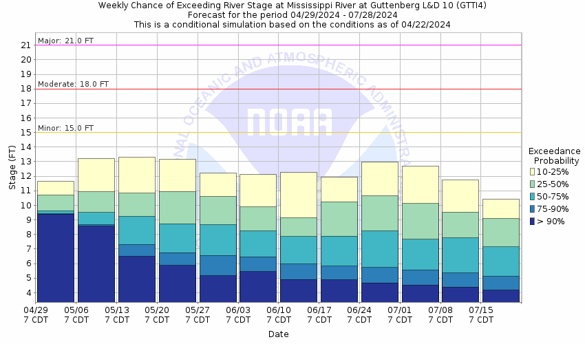
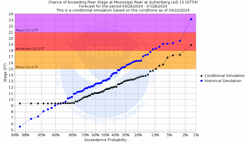
Mississippi River Below Lock and Dam 10 - Guttenberg (GTTI4)
Return to TopNOTE: River forecasts for this location take into account past precipitation and the precipitation amounts expected approximately 24 hours into the future from the forecast issuance time.
Flood Stage: 15 Feet
Latest Stage: 9.12
Vertical Datum is the USACE 1912 datum
NOTE:Forecasts for the Mississippi River below Lock and Dam 10 - Guttenberg are issued routinely during the navigation season, and as needed at other times of the year.
Vertical Datum is the USACE 1912 datum
Flood Categories (in feet)
| Major Flood Stage: |
21 |
| Moderate Flood Stage: |
18 |
| Flood Stage: |
15 |
| Action Stage: |
12 |
| Low Stage (in feet): |
-9999 |
Historic Crests
(1) 23.65 ft on 04/24/1965
(2) 21.68 ft on 04/21/2001
(3) 20.98 ft on 04/28/2023
(P)
(4) 20.15 ft on 06/30/1993
(5) 19.98 ft on 04/27/2019
Show More Historic Crests
(P): Preliminary values subject to further review.
Recent Crests
(1) 20.98 ft on 04/28/2023
(P)
(2) 15.26 ft on 10/13/2019
(P)
(3) 17.59 ft on 05/31/2019
(4) 19.98 ft on 04/27/2019
(5) 16.14 ft on 05/28/2017
Show More Recent Crests
(P): Preliminary values subject to further review.
Probabilistic Stage Forecast for Lock and Dam 10 - Guttenberg
Stage Exceedance Forecast for Lock and Dam 10 - Guttenberg
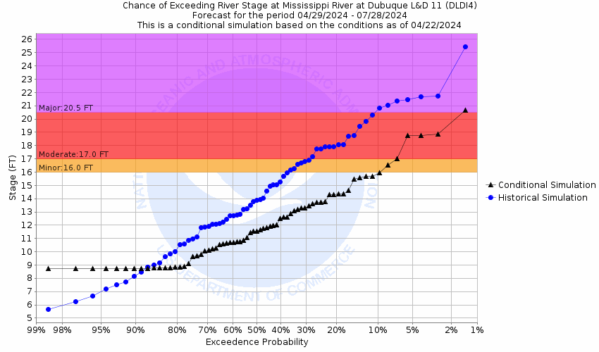
Mississippi River At Dubuque (LD11) (DLDI4)
Return to TopNOTE: River forecasts for this location take into account past precipitation and the precipitation amounts expected approximately 24 hours into the future from the forecast issuance time.
Flood Stage: 16 Feet
Latest Stage: 8.35
NOTE:Forecasts for the Mississippi River at Dubuque (LD11) are issued routinely year-round.
Flood Categories (in feet)
| Major Flood Stage: |
20.5 |
| Moderate Flood Stage: |
17 |
| Flood Stage: |
16 |
| Action Stage: |
15 |
| Low Stage (in feet): |
-9999 |
Historic Crests
(1) 25.69 ft on 04/26/1965
(2) 23.91 ft on 04/21/2001
(3) 23.03 ft on 04/29/2023
(P)
(4) 22.32 ft on 07/01/1993
(5) 21.77 ft on 04/27/2019
(6) 21.74 ft on 04/23/1969
(7) 21.64 ft on 04/22/1951
(8) 21.57 ft on 04/25/1952
(9) 21.32 ft on 05/06/1975
(10) 21.24 ft on 04/19/2011
Show More Historic Crests
(P): Preliminary values subject to further review.
Recent Crests
(1) 23.03 ft on 04/29/2023
(P)
(2) 19.19 ft on 05/31/2019
(P)
(3) 21.77 ft on 04/27/2019
(4) 21.22 ft on 04/06/2019
(P)
(5) 17.87 ft on 05/07/2018
(6) 17.04 ft on 05/29/2017
(7) 15.91 ft on 09/30/2016
(8) 11.23 ft on 06/06/2015
(9) 18.46 ft on 07/04/2014
(10) 16.30 ft on 06/26/2013
Show More Recent Crests
(P): Preliminary values subject to further review.
Low Water Records
Currently none available.
Probabilistic Stage Forecast for Dubuque (LD11)
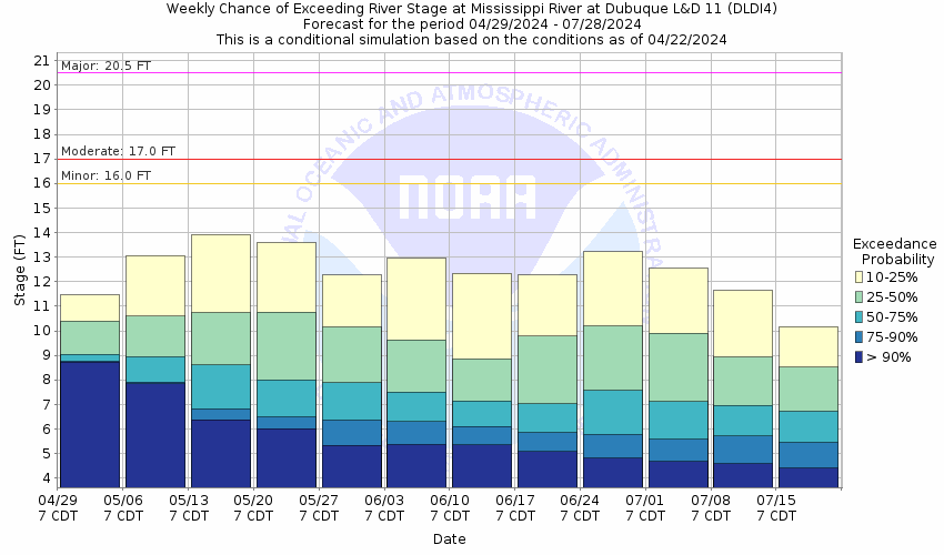
Stage Exceedance Forecast for Dubuque (LD11)
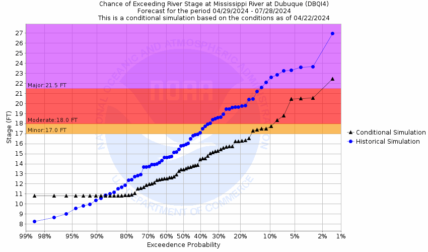
Mississippi River At Dubuque (Railroad Bridge) (DBQI4)
Return to TopNOTE: River forecasts for this location take into account past precipitation and the precipitation amounts expected approximately 24 hours into the future from the forecast issuance time.
Flood Stage: 17 Feet
Latest Stage: 10.6
NOTE:Forecasts for the Mississippi River at Dubuque (Railroad Bridge) are issued routinely year-round.
Flood Categories (in feet)
| Major Flood Stage: |
21.5 |
| Moderate Flood Stage: |
18 |
| Flood Stage: |
17 |
| Action Stage: |
15 |
| Low Stage (in feet): |
-9999 |
Historic Crests
(1) 26.81 ft on 04/26/1965
(2) 25.40 ft on 04/21/2001
(3) 24.30 ft on 04/29/2023
(P)
(4) 23.84 ft on 07/01/1993
(5) 23.18 ft on 04/27/2019
(6) 23.11 ft on 04/23/1969
(7) 22.82 ft on 04/19/2011
(8) 22.80 ft on 04/16/1997
(9) 22.78 ft on 05/06/1975
(10) 22.70 ft on 04/25/1952
Show More Historic Crests
(P): Preliminary values subject to further review.
Recent Crests
(1) 24.30 ft on 04/29/2023
(P)
(2) 20.75 ft on 05/31/2019
(P)
(3) 23.18 ft on 04/27/2019
(4) 22.65 ft on 04/06/2019
(P)
(5) 19.66 ft on 05/08/2018
(6) 18.80 ft on 05/29/2017
(7) 17.78 ft on 09/30/2016
(8) 17.23 ft on 03/26/2016
(9) 13.31 ft on 06/06/2015
(10) 20.24 ft on 07/03/2014
Show More Recent Crests
(P): Preliminary values subject to further review.
Low Water Records
Currently none available.
Probabilistic Stage Forecast for Dubuque (Railroad Bridge)
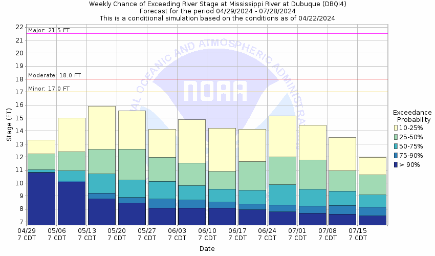
Stage Exceedance Forecast for Dubuque (Railroad Bridge)
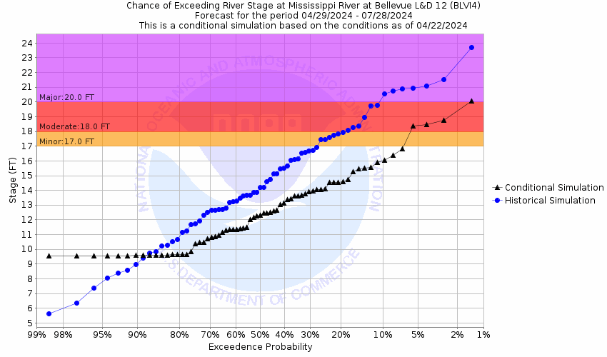
Mississippi River At Bellevue (BLVI4)
Return to TopNOTE: River forecasts for this location take into account past precipitation and the precipitation amounts expected approximately 24 hours into the future from the forecast issuance time.
Flood Stage: 17 Feet
Latest Stage: 9.15
NOTE:Forecasts for the Mississippi River at Bellevue are issued routinely year-round.
Flood Categories (in feet)
| Major Flood Stage: |
20 |
| Moderate Flood Stage: |
18 |
| Flood Stage: |
17 |
| Action Stage: |
16 |
| Low Stage (in feet): |
-9999 |
Historic Crests
(1) 23.51 ft on 04/26/1965
(2) 22.58 ft on 04/22/2001
(3) 21.78 ft on 04/29/2023
(P)
(4) 21.50 ft on 07/01/1993
(5) 20.87 ft on 04/29/2019
(6) 20.58 ft on 04/20/2011
(7) 20.16 ft on 04/17/1997
(8) 20.11 ft on 04/26/1952
(9) 20.06 ft on 04/24/1969
(10) 20.00 ft on 04/23/1951
Show More Historic Crests
(P): Preliminary values subject to further review.
Recent Crests
(1) 21.78 ft on 04/29/2023
(P)
(2) 20.87 ft on 04/29/2019
(3) 17.56 ft on 05/08/2018
(4) 16.89 ft on 05/29/2017
(5) 16.13 ft on 09/30/2016
(6) 12.22 ft on 06/07/2015
(7) 18.68 ft on 07/03/2014
(8) 16.70 ft on 06/26/2013
(9) 20.58 ft on 04/20/2011
(10) 18.70 ft on 06/14/2008
Show More Recent Crests
(P): Preliminary values subject to further review.
Low Water Records
Currently none available.
Probabilistic Stage Forecast for Bellevue

Stage Exceedance Forecast for Bellevue
Mississippi River At Fulton (FLTI2)
Return to TopNOTE: River forecasts for this location take into account past precipitation and the precipitation amounts expected approximately 24 hours into the future from the forecast issuance time.
Flood Stage: 16 Feet
Latest Stage: 8.52
NOTE:Forecasts for the Mississippi River at Fulton are issued routinely year-round.
Flood Categories (in feet)
| Major Flood Stage: |
20 |
| Moderate Flood Stage: |
18 |
| Flood Stage: |
16 |
| Action Stage: |
15 |
| Low Stage (in feet): |
-9999 |
Historic Crests
(1) 24.75 ft on 04/28/1965
(2) 23.31 ft on 04/24/2001
(3) 22.17 ft on 07/08/1993
(4) 22.06 ft on 04/30/2023
(P)
(5) 21.77 ft on 04/30/2019
(6) 21.37 ft on 04/26/1969
(7) 21.23 ft on 04/27/1952
(8) 21.06 ft on 04/21/2011
(9) 21.00 ft on 04/26/1951
(10) 20.91 ft on 04/08/2019
(P)
Show More Historic Crests
(P): Preliminary values subject to further review.
Recent Crests
(1) 22.06 ft on 04/30/2023
(P)
(2) 19.83 ft on 06/05/2019
(P)
(3) 21.77 ft on 04/30/2019
(4) 20.91 ft on 04/08/2019
(P)
(5) 17.61 ft on 05/10/2018
(6) 16.69 ft on 05/31/2017
(7) 15.93 ft on 09/30/2016
(8) 12.03 ft on 06/16/2015
(9) 19.27 ft on 07/03/2014
(10) 16.92 ft on 04/20/2013
Show More Recent Crests
(P): Preliminary values subject to further review.
Low Water Records
Currently none available.
Probabilistic Stage Forecast for Fulton
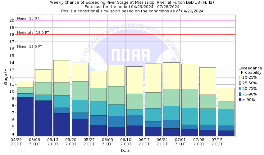
Stage Exceedance Forecast for Fulton

Mississippi River At Camanche (CMMI4)
Return to TopNOTE: River forecasts for this location take into account past precipitation and the precipitation amounts expected approximately 24 hours into the future from the forecast issuance time.
Flood Stage: 17 Feet
Latest Stage: 11.78
NOTE:Forecasts for the Mississippi River at Camanche are issued routinely year-round.
Flood Categories (in feet)
| Major Flood Stage: |
20.5 |
| Moderate Flood Stage: |
18.5 |
| Flood Stage: |
17 |
| Action Stage: |
16 |
| Low Stage (in feet): |
-9999 |
Historic Crests
(1) 24.65 ft on 04/28/1965
(2) 23.62 ft on 04/24/2001
(3) 23.55 ft on 04/23/2001
(4) 22.98 ft on 07/08/1993
(5) 22.87 ft on 07/07/1993
(6) 22.86 ft on 04/30/2023
(P)
(7) 22.77 ft on 05/01/2019
(8) 22.65 ft on 04/30/2019
(9) 21.93 ft on 04/21/2011
(10) 21.91 ft on 04/08/2019
Show More Historic Crests
(P): Preliminary values subject to further review.
Recent Crests
(1) 22.86 ft on 04/30/2023
(P)
(2) 19.13 ft on 04/10/2020
(P)
(3) 21.23 ft on 06/01/2019
(4) 22.77 ft on 05/01/2019
(5) 22.65 ft on 04/30/2019
(6) 21.91 ft on 04/08/2019
(7) 18.97 ft on 05/10/2018
(8) 18.86 ft on 05/09/2018
(9) 18.23 ft on 05/31/2017
(10) 18.15 ft on 05/30/2017
Show More Recent Crests
(P): Preliminary values subject to further review.
Low Water Records
Currently none available.
Probabilistic Stage Forecast for Camanche

Stage Exceedance Forecast for Camanche

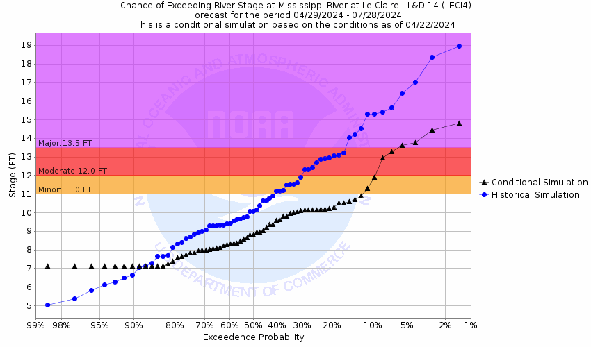
Mississippi River At LeClaire (LECI4)
Return to TopNOTE: River forecasts for this location take into account past precipitation and the precipitation amounts expected approximately 24 hours into the future from the forecast issuance time.
Flood Stage: 11 Feet
Latest Stage: 6.54
Current Warnings/Statements/Advisories:None currently.
NOTE:Forecasts for the Mississippi River at LeClaire are issued routinely year-round.
Flood Categories (in feet)
| Major Flood Stage: |
13.5 |
| Moderate Flood Stage: |
12 |
| Flood Stage: |
11 |
| Action Stage: |
10 |
| Low Stage (in feet): |
-9999 |
Historic Crests
(1) 17.75 ft on 04/28/1965
(2) 16.93 ft on 04/24/2001
(3) 16.56 ft on 07/08/1993
(4) 16.50 ft on 05/02/2019
(5) 16.18 ft on 05/01/2023
(P)
(6) 14.97 ft on 04/22/2011
(7) 14.84 ft on 06/16/2008
(8) 14.61 ft on 04/19/1997
(9) 14.60 ft on 04/26/1969
(10) 14.45 ft on 07/03/2014
Show More Historic Crests
(P): Preliminary values subject to further review.
Recent Crests
(1) 16.18 ft on 05/01/2023
(P)
(2) 16.50 ft on 05/02/2019
(3) 12.25 ft on 05/10/2018
(4) 11.47 ft on 06/01/2017
(5) 10.76 ft on 09/30/2016
(6) 8.96 ft on 06/16/2015
(7) 14.45 ft on 07/03/2014
(8) 12.57 ft on 04/20/2013
(9) 14.97 ft on 04/22/2011
(10) 11.05 ft on 04/04/2011
Show More Recent Crests
(P): Preliminary values subject to further review.
Low Water Records
Currently none available.
Probabilistic Stage Forecast for LeClaire
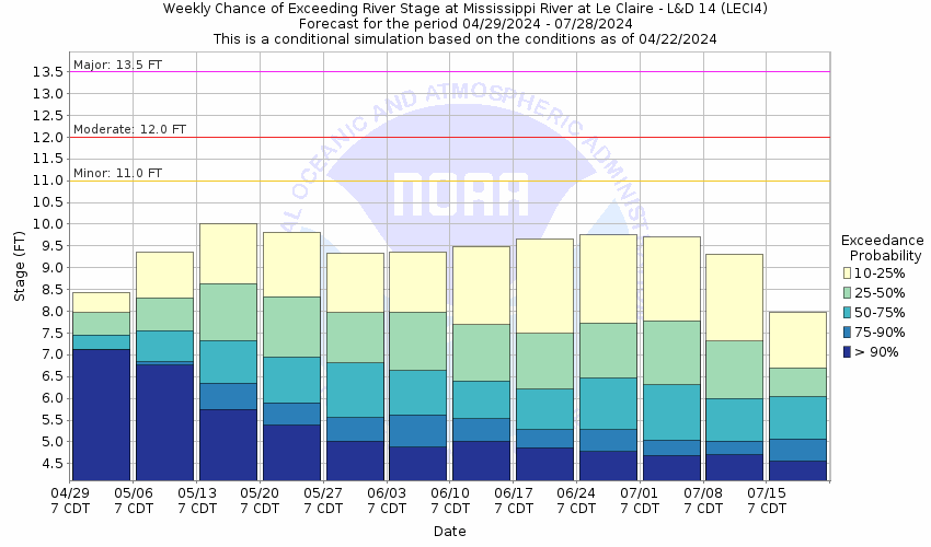
Stage Exceedance Forecast for LeClaire
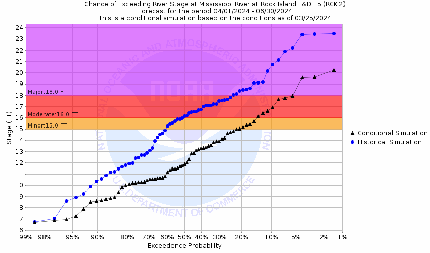
Mississippi River At Rock Island (RCKI2)
Return to TopNOTE: River forecasts for this location take into account past precipitation and the precipitation amounts expected approximately 24 hours into the future from the forecast issuance time.
Flood Stage: 15 Feet
Latest Stage: 9.51
Current Warnings/Statements/Advisories:None currently.
NOTE:Forecasts for the Mississippi River at Rock Island are issued routinely year-round.
Flood Categories (in feet)
| Major Flood Stage: |
18 |
| Moderate Flood Stage: |
16 |
| Flood Stage: |
15 |
| Action Stage: |
13 |
| Low Stage (in feet): |
-9999 |
Historic Crests
(1) 22.70 ft on 05/02/2019
(2) 22.63 ft on 07/09/1993
(3) 22.48 ft on 04/28/1965
(4) 22.33 ft on 04/25/2001
(5) 22.00 ft on 03/10/1868
(6) 21.68 ft on 06/01/2019
(7) 21.51 ft on 05/01/2023
(P)
(8) 21.49 ft on 06/16/2008
(9) 20.90 ft on 07/04/2014
(10) 20.71 ft on 04/22/2011
Show More Historic Crests
(P): Preliminary values subject to further review.
Recent Crests
(1) 21.51 ft on 05/01/2023
(P)
(2) 21.68 ft on 06/01/2019
(3) 22.70 ft on 05/02/2019
(4) 20.68 ft on 04/08/2019
(5) 17.41 ft on 05/11/2018
(6) 17.07 ft on 05/31/2017
(7) 15.82 ft on 09/30/2016
(8) 13.75 ft on 06/17/2015
(9) 20.90 ft on 07/04/2014
(10) 19.12 ft on 04/21/2013
Show More Recent Crests
(P): Preliminary values subject to further review.
Low Water Records
Currently none available.
Probabilistic Stage Forecast for Rock Island

Stage Exceedance Forecast for Rock Island
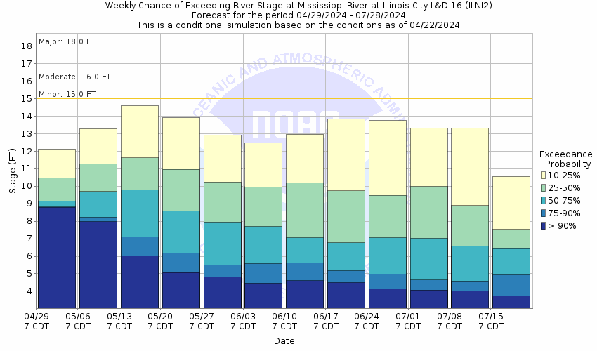
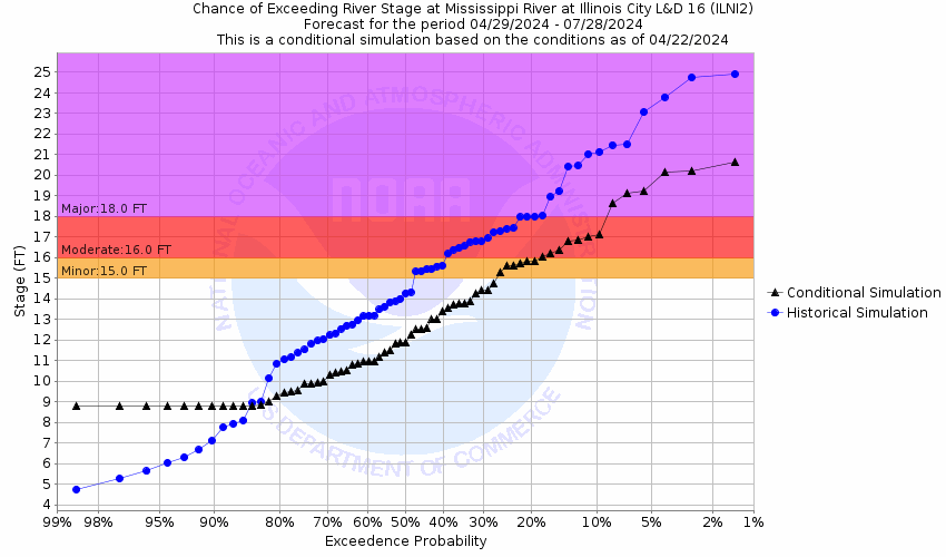
Mississippi River At Illinois City (ILNI2)
Return to TopNOTE: River forecasts for this location take into account past precipitation and the precipitation amounts expected approximately 24 hours into the future from the forecast issuance time.
Flood Stage: 15 Feet
Latest Stage: 8.17
Current Warnings/Statements/Advisories:None currently.
NOTE:Forecasts for the Mississippi River at Illinois City are issued routinely year-round.
Flood Categories (in feet)
| Major Flood Stage: |
18 |
| Moderate Flood Stage: |
16 |
| Flood Stage: |
15 |
| Action Stage: |
14 |
| Low Stage (in feet): |
-9999 |
Historic Crests
(1) 24.10 ft on 07/09/1993
(2) 23.27 ft on 04/28/1965
(3) 23.23 ft on 05/03/2019
(4) 22.96 ft on 06/17/2008
(5) 22.81 ft on 06/02/2019
(6) 22.41 ft on 04/25/2001
(7) 22.23 ft on 07/05/2014
(8) 21.22 ft on 05/02/2023
(P)
(9) 20.83 ft on 04/10/2019
(10) 20.74 ft on 04/23/2011
Show More Historic Crests
(P): Preliminary values subject to further review.
Recent Crests
(1) 21.22 ft on 05/02/2023
(P)
(2) 22.81 ft on 06/02/2019
(3) 23.23 ft on 05/03/2019
(4) 20.83 ft on 04/10/2019
(5) 19.39 ft on 10/13/2018
(6) 17.22 ft on 05/12/2018
(7) 16.76 ft on 06/01/2017
(8) 15.87 ft on 09/30/2016
(9) 15.11 ft on 03/29/2016
(10) 13.52 ft on 06/18/2015
Show More Recent Crests
(P): Preliminary values subject to further review.
Low Water Records
Currently none available.
Probabilistic Stage Forecast for Illinois City
Stage Exceedance Forecast for Illinois City
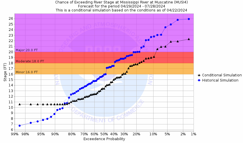
Mississippi River At Muscatine (MUSI4)
Return to TopNOTE: River forecasts for this location take into account past precipitation and the precipitation amounts expected approximately 24 hours into the future from the forecast issuance time.
Flood Stage: 16 Feet
Latest Stage: 9.85
Current Warnings/Statements/Advisories:None currently.
NOTE:Forecasts for the Mississippi River at Muscatine are issued routinely year-round.
Flood Categories (in feet)
| Major Flood Stage: |
20 |
| Moderate Flood Stage: |
18 |
| Flood Stage: |
16 |
| Action Stage: |
15 |
| Low Stage (in feet): |
-9999 |
Historic Crests
(1) 25.61 ft on 07/09/1993
(2) 24.81 ft on 04/29/1965
(3) 24.52 ft on 06/02/2019
(4) 24.42 ft on 06/17/2008
(5) 24.33 ft on 05/03/2019
(P)
(6) 23.75 ft on 07/05/2014
(7) 23.50 ft on 04/25/2001
(8) 22.31 ft on 05/02/2023
(P)
(9) 21.95 ft on 04/10/2019
(P)
(10) 21.87 ft on 04/23/2011
Show More Historic Crests
(P): Preliminary values subject to further review.
Recent Crests
(1) 22.31 ft on 05/02/2023
(P)
(2) 24.52 ft on 06/02/2019
(3) 24.33 ft on 05/03/2019
(P)
(4) 21.95 ft on 04/10/2019
(P)
(5) 18.80 ft on 05/12/2018
(6) 18.20 ft on 06/01/2017
(7) 17.67 ft on 09/30/2016
(8) 15.31 ft on 06/18/2015
(9) 23.75 ft on 07/05/2014
(10) 21.86 ft on 04/22/2013
Show More Recent Crests
(P): Preliminary values subject to further review.
Low Water Records
Currently none available.
Probabilistic Stage Forecast for Muscatine

Stage Exceedance Forecast for Muscatine
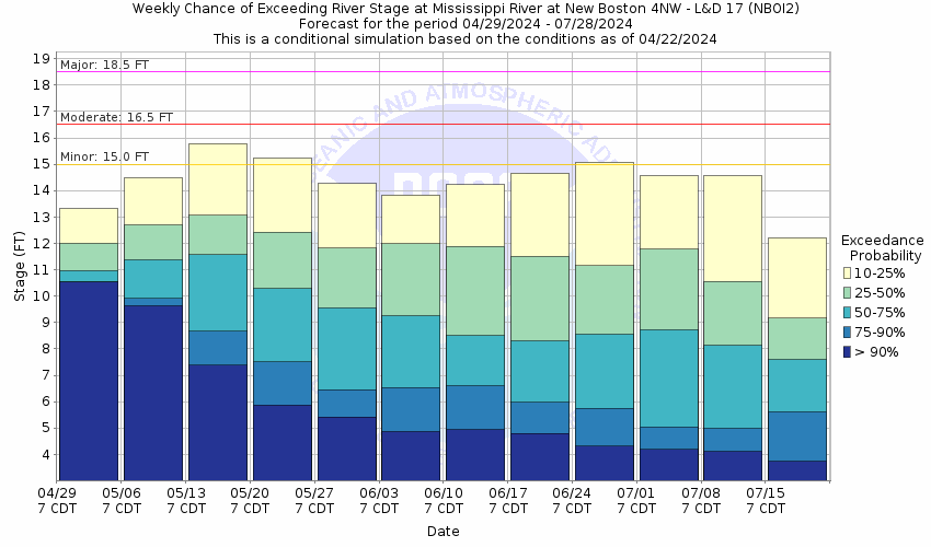
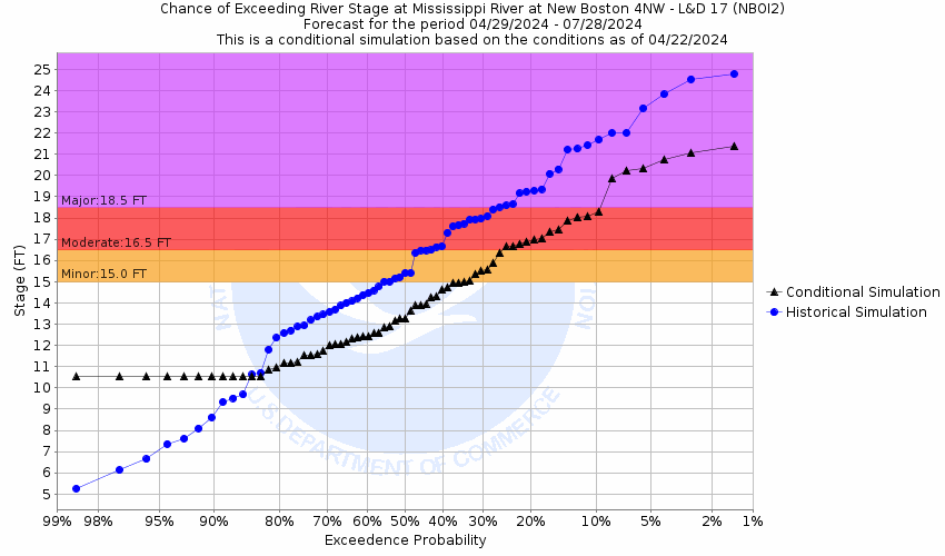
Mississippi River At New Boston (NBOI2)
Return to TopNOTE: River forecasts for this location take into account past precipitation and the precipitation amounts expected approximately 24 hours into the future from the forecast issuance time.
Flood Stage: 15 Feet
Latest Stage: 9.43
Current Warnings/Statements/Advisories:None currently.
NOTE:Forecasts for the Mississippi River at New Boston are issued routinely year-round.
Flood Categories (in feet)
| Major Flood Stage: |
18.5 |
| Moderate Flood Stage: |
16.5 |
| Flood Stage: |
15 |
| Action Stage: |
14 |
| Low Stage (in feet): |
-9999 |
Historic Crests
(1) 25.90 ft on 07/09/1993
(2) 25.20 ft on 06/17/2008
(3) 24.42 ft on 06/01/2019
(4) 23.59 ft on 05/03/2019
(5) 23.14 ft on 04/28/1965
(6) 22.46 ft on 04/25/2001
(7) 21.83 ft on 05/01/2008
(8) 21.73 ft on 04/25/1973
(9) 21.04 ft on 04/10/2019
(10) 20.96 ft on 04/24/2011
Show More Historic Crests
(P): Preliminary values subject to further review.
Recent Crests
(1) 20.85 ft on 05/03/2023
(P)
(2) 24.42 ft on 06/01/2019
(3) 23.59 ft on 05/03/2019
(4) 21.04 ft on 04/10/2019
(5) 18.47 ft on 05/12/2018
(6) 17.79 ft on 06/01/2017
(7) 18.70 ft on 09/30/2016
(8) 16.24 ft on 03/29/2016
(9) 15.54 ft on 06/19/2015
(10) 20.96 ft on 04/24/2011
Show More Recent Crests
(P): Preliminary values subject to further review.
Low Water Records
Currently none available.
Probabilistic Stage Forecast for New Boston
Stage Exceedance Forecast for New Boston
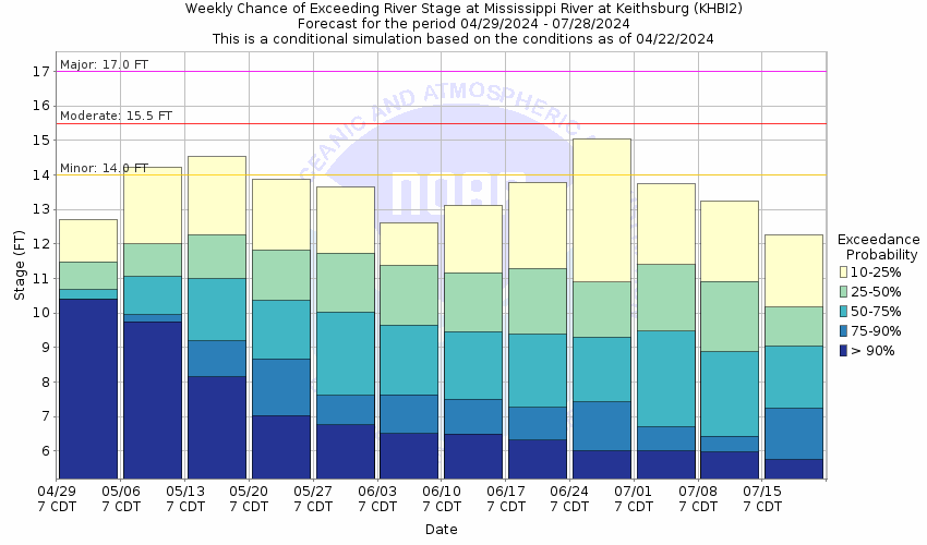
Mississippi River At Keithsburg (KHBI2)
Return to TopNOTE: River forecasts for this location take into account past precipitation and the precipitation amounts expected approximately 24 hours into the future from the forecast issuance time.
Flood Stage: 14 Feet
Latest Stage: 9.84
Current Warnings/Statements/Advisories:None currently.
NOTE:Forecasts for the Mississippi River at Keithsburg are issued routinely year-round.
Flood Categories (in feet)
| Major Flood Stage: |
17 |
| Moderate Flood Stage: |
15.5 |
| Flood Stage: |
14 |
| Action Stage: |
13 |
| Low Stage (in feet): |
-9999 |
Historic Crests
(1) 24.49 ft on 06/17/2008
(2) 24.15 ft on 07/09/1993
(3) 22.95 ft on 06/02/2019
(4) 22.62 ft on 07/05/2014
(5) 21.97 ft on 05/03/2019
(6) 20.72 ft on 05/12/2001
(7) 20.60 ft on 04/22/2013
(8) 20.46 ft on 04/28/1965
(9) 20.35 ft on 05/02/2008
(10) 19.35 ft on 04/25/1973
Show More Historic Crests
(P): Preliminary values subject to further review.
Recent Crests
(1) 19.12 ft on 05/03/2023
(P)
(2) 14.29 ft on 06/07/2020
(3) 22.95 ft on 06/02/2019
(4) 21.97 ft on 05/03/2019
(5) 19.17 ft on 04/10/2019
(6) 14.24 ft on 02/08/2019
(7) 17.27 ft on 09/09/2018
(8) 16.57 ft on 06/01/2017
(9) 17.30 ft on 09/30/2016
(10) 15.03 ft on 03/30/2016
Show More Recent Crests
(P): Preliminary values subject to further review.
Low Water Records
Currently none available.
Probabilistic Stage Forecast for Keithsburg
Stage Exceedance Forecast for Keithsburg

Mississippi River At Gladstone (GLDI2)
Return to TopNOTE: River forecasts for this location take into account past precipitation and the precipitation amounts expected approximately 24 hours into the future from the forecast issuance time.
Flood Stage: 10 Feet
Latest Stage: 6.08
Current Warnings/Statements/Advisories:None currently.
NOTE:Forecasts for the Mississippi River at Gladstone are issued routinely year-round.
Flood Categories (in feet)
| Major Flood Stage: |
14 |
| Moderate Flood Stage: |
12 |
| Flood Stage: |
10 |
| Action Stage: |
9 |
| Low Stage (in feet): |
-9999 |
Historic Crests
(1) 22.46 ft on 06/17/2008
(2) 21.54 ft on 07/10/1993
(3) 20.59 ft on 06/02/2019
(4) 19.77 ft on 07/05/2014
(5) 19.67 ft on 05/03/2019
(6) 18.00 ft on 04/22/2013
(7) 17.65 ft on 05/12/2001
(8) 17.40 ft on 04/25/1973
(9) 17.10 ft on 04/27/1965
(10) 17.04 ft on 05/02/2008
Show More Historic Crests
(P): Preliminary values subject to further review.
Recent Crests
(1) 15.93 ft on 05/04/2023
(P)
(2) 10.63 ft on 06/30/2020
(3) 11.06 ft on 06/07/2020
(4) 20.59 ft on 06/02/2019
(5) 19.67 ft on 05/03/2019
(6) 16.30 ft on 04/10/2019
(7) 14.23 ft on 09/10/2018
(8) 13.32 ft on 06/01/2017
(9) 13.74 ft on 09/30/2016
(10) 11.55 ft on 03/29/2016
Show More Recent Crests
(P): Preliminary values subject to further review.
Low Water Records
Currently none available.
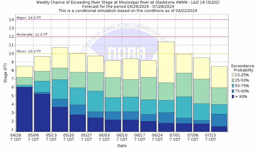
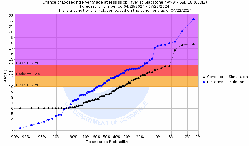
Probabilistic Stage Forecast for Gladstone
Stage Exceedance Forecast for Gladstone
Mississippi River At Burlington (BRLI4)
Return to TopNOTE: River forecasts for this location take into account past precipitation and the precipitation amounts expected approximately 24 hours into the future from the forecast issuance time.
Flood Stage: 15 Feet
Latest Stage: 11.44
Current Warnings/Statements/Advisories:None currently.
NOTE:Forecasts for the Mississippi River at Burlington are issued routinely year-round.
Flood Categories (in feet)
| Major Flood Stage: |
18 |
| Moderate Flood Stage: |
16.5 |
| Flood Stage: |
15 |
| Action Stage: |
14 |
| Low Stage (in feet): |
-9999 |
Historic Crests
(1) 25.73 ft on 06/17/2008
(2) 25.10 ft on 07/10/1993
(3) 24.47 ft on 06/02/2019
(4) 23.65 ft on 07/06/2014
(5) 23.54 ft on 05/03/2019
(6) 21.82 ft on 05/14/2001
(7) 21.50 ft on 04/25/1973
(8) 21.18 ft on 05/02/2008
(9) 21.00 ft on 04/30/1965
(10) 20.51 ft on 03/25/2019
Show More Historic Crests
(P): Preliminary values subject to further review.
Recent Crests
(1) 20.00 ft on 05/04/2023
(P)
(2) 18.21 ft on 04/13/2020
(3) 18.36 ft on 10/15/2019
(4) 24.47 ft on 06/02/2019
(5) 23.54 ft on 05/03/2019
(6) 20.41 ft on 04/10/2019
(7) 20.51 ft on 03/25/2019
(8) 18.65 ft on 09/11/2018
(9) 17.73 ft on 07/03/2018
(10) 18.14 ft on 05/13/2018
Show More Recent Crests
(P): Preliminary values subject to further review.
Low Water Records
Currently none available.
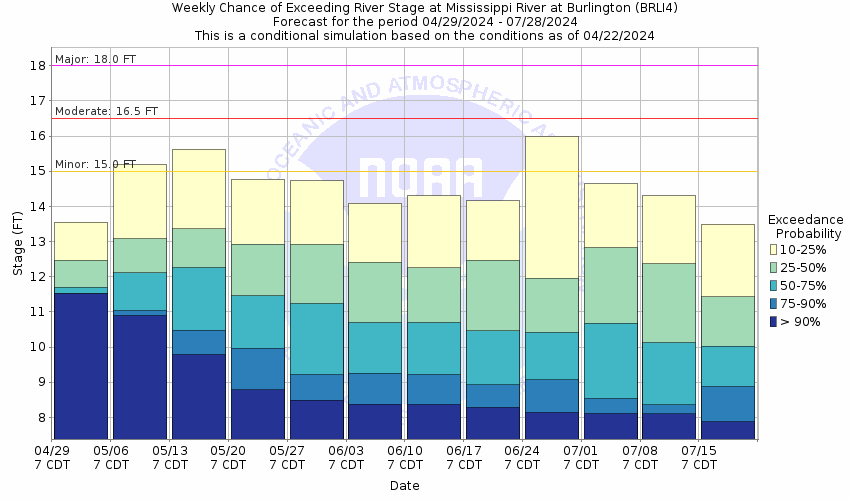
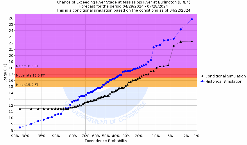
Probabilistic Stage Forecast for Burlington
Stage Exceedance Forecast for Burlington
Mississippi River At Keokuk (EOKI4)
Return to TopNOTE: River forecasts for this location take into account past precipitation and the precipitation amounts expected approximately 24 hours into the future from the forecast issuance time.
Flood Stage: 16 Feet
Latest Stage: 7.04
Current Warnings/Statements/Advisories:None currently.
NOTE:Forecasts for the Mississippi River at Keokuk are issued routinely year-round.
Flood Categories (in feet)
| Major Flood Stage: |
19 |
| Moderate Flood Stage: |
17.5 |
| Flood Stage: |
16 |
| Action Stage: |
14 |
| Low Stage (in feet): |
-9999 |
Historic Crests
(1) 27.58 ft on 07/10/1993
(2) 26.95 ft on 06/17/2008
(3) 25.60 ft on 05/30/2019
(4) 23.50 ft on 05/02/2019
(5) 23.50 ft on 04/23/1973
(6) 23.38 ft on 07/07/2014
(7) 22.94 ft on 05/14/2001
(8) 22.20 ft on 04/20/2013
(9) 22.14 ft on 05/01/1965
(10) 21.83 ft on 04/04/1960
Show More Historic Crests
(P): Preliminary values subject to further review.
Recent Crests
(1) 17.71 ft on 05/05/2023
(P)
(2) 25.60 ft on 05/30/2019
(3) 23.50 ft on 05/02/2019
(4) 19.78 ft on 04/11/2019
(5) 16.91 ft on 09/11/2018
(6) 16.19 ft on 06/02/2017
(7) 16.84 ft on 12/28/2015
(8) 16.50 ft on 06/27/2015
(9) 23.38 ft on 07/07/2014
(10) 22.20 ft on 04/20/2013
Show More Recent Crests
(P): Preliminary values subject to further review.
Low Water Records
Currently none available.
Probabilistic Stage Forecast for Keokuk
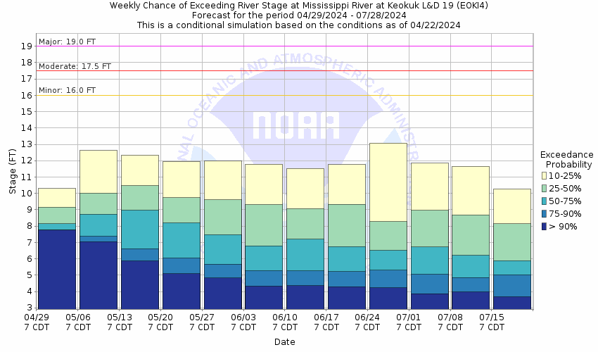
Stage Exceedance Forecast for Keokuk

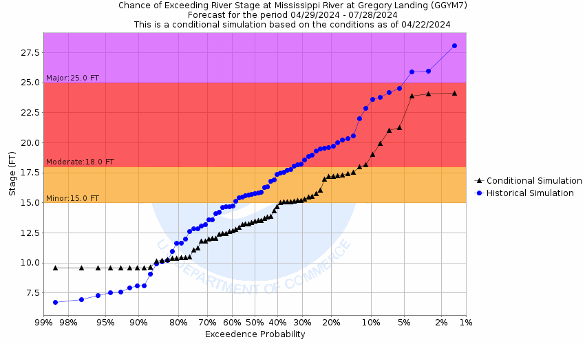
Mississippi River At Gregory Landing (GGYM7)
Return to TopNOTE: River forecasts for this location take into account past precipitation and the precipitation amounts expected approximately 24 hours into the future from the forecast issuance time.
Flood Stage: 15 Feet
Latest Stage: 8.03
Current Warnings/Statements/Advisories:None currently.
NOTE:Forecasts for the Mississippi River at Gregory Landing are issued routinely year-round.
Flood Categories (in feet)
| Major Flood Stage: |
25 |
| Moderate Flood Stage: |
18 |
| Flood Stage: |
15 |
| Action Stage: |
14 |
| Low Stage (in feet): |
-9999 |
Historic Crests
(1) 28.49 ft on 07/09/1993
(2) 27.60 ft on 06/18/2008
(3) 26.97 ft on 06/02/2019
(4) 25.16 ft on 05/03/2019
(5) 24.60 ft on 04/24/1973
(6) 24.42 ft on 07/07/2014
(7) 24.04 ft on 05/15/2001
(8) 23.55 ft on 04/20/2013
(9) 22.70 ft on 05/01/1965
(10) 21.50 ft on 04/03/1960
Show More Historic Crests
(P): Preliminary values subject to further review.
Recent Crests
(1) 18.79 ft on 05/05/2023
(P)
(2) 15.40 ft on 06/11/2020
(3) 26.97 ft on 06/02/2019
(4) 25.16 ft on 05/03/2019
(5) 20.92 ft on 04/11/2019
(6) 15.60 ft on 03/11/2019
(7) 18.81 ft on 02/13/2019
(8) 18.02 ft on 09/10/2018
(9) 17.26 ft on 06/02/2017
(10) 17.71 ft on 10/06/2016
Show More Recent Crests
(P): Preliminary values subject to further review.
Low Water Records
Currently none available.
Probabilistic Stage Forecast for Gregory Landing
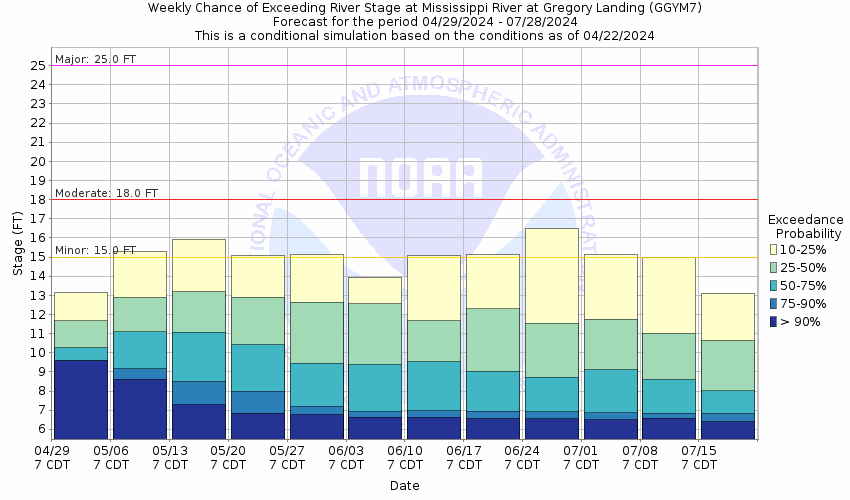
Stage Exceedance Forecast for Gregory Landing