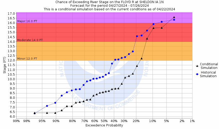
Floyd River At Sheldon (SHLI4)
Return to TopNOTE: River forecasts for this location take into account past precipitation and the precipitation amounts expected approximately 48 hours into the future from the forecast issuance time.
Flood Stage: 12 Feet
Latest Stage: 4.7
Current Warnings/Statements/Advisories:None currently.
NOTE:Forecasts for the Floyd River at Sheldon are issued as needed during times of high water, but are not routinely available.
Flood Categories (in feet)
| Major Flood Stage: |
16 |
| Moderate Flood Stage: |
14 |
| Flood Stage: |
12 |
| Action Stage: |
10 |
| Low Stage (in feet): |
-9999 |
Historic Crests
(1) 19.96 ft on 06/07/1953
(2) 15.50 ft on 06/21/2018
(3) 14.10 ft on 07/22/2010
(4) 13.70 ft on 03/14/2019
(5) 13.00 ft on 03/28/1962
Show More Historic Crests
(P): Preliminary values subject to further review.
Recent Crests
(1) 7.81 ft on 09/28/2023
(2) 7.79 ft on 05/26/2020
(3) 13.70 ft on 03/14/2019
(4) 15.50 ft on 06/21/2018
(5) 12.65 ft on 06/18/2014
Show More Recent Crests
(P): Preliminary values subject to further review.
Low Water Records
Currently none available.
Probabilistic Stage Forecast for Sheldon
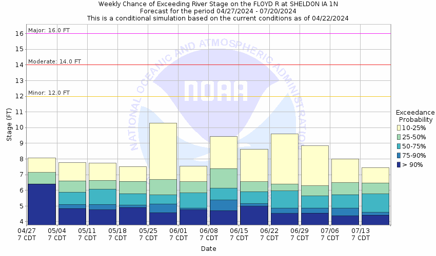
Stage Exceedance Forecast for Sheldon
Floyd River At Alton (ALTI4)
Return to TopNOTE: River forecasts for this location take into account past precipitation and the precipitation amounts expected approximately 48 hours into the future from the forecast issuance time.
Flood Stage: 12 Feet
Latest Stage: 6.35
Current Warnings/Statements/Advisories:None currently.
NOTE:Forecasts for the Floyd River at Alton are issued as needed during times of high water, but are not routinely available.
Flood Categories (in feet)
| Major Flood Stage: |
18 |
| Moderate Flood Stage: |
16 |
| Flood Stage: |
12 |
| Action Stage: |
10 |
| Low Stage (in feet): |
-9999 |
Historic Crests
(1) 21.96 ft on 09/20/2018
(2) 20.87 ft on 03/14/2019
(3) 20.50 ft on 06/21/2018
(4) 19.19 ft on 05/27/2013
(5) 18.54 ft on 06/20/1983
Show More Historic Crests
(P): Preliminary values subject to further review.
Recent Crests
(1) 9.09 ft on 05/13/2023
(2) 6.43 ft on 06/25/2022
(3) 6.16 ft on 07/14/2021
(4) 8.82 ft on 05/27/2020
(5) 20.87 ft on 03/14/2019
Show More Recent Crests
(P): Preliminary values subject to further review.
Low Water Records
Currently none available.
Probabilistic Stage Forecast for Alton
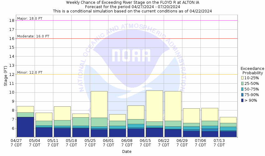
Stage Exceedance Forecast for Alton

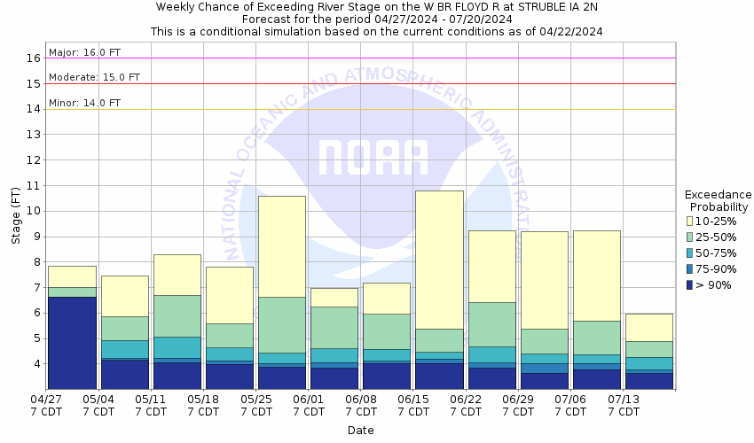
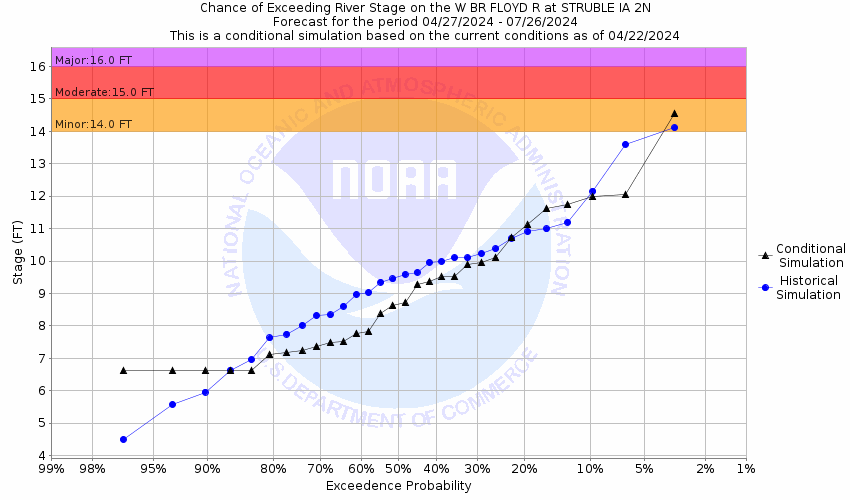
Floyd River Near Struble (STUI4)
Return to TopNOTE: River forecasts for this location take into account past precipitation and the precipitation amounts expected approximately 48 hours into the future from the forecast issuance time.
Flood Stage: 14 Feet
Latest Stage: 5.09
Current Warnings/Statements/Advisories:None currently.
NOTE:Forecasts for the Floyd River near Struble are issued as needed during times of high water, but are not routinely available.
Flood Categories (in feet)
| Major Flood Stage: |
16 |
| Moderate Flood Stage: |
15 |
| Flood Stage: |
14 |
| Action Stage: |
12 |
| Low Stage (in feet): |
-9999 |
Historic Crests
(1) 16.41 ft on 03/14/2019
(2) 16.24 ft on 09/21/2018
(3) 15.86 ft on 07/30/2010
(4) 15.86 ft on 03/04/1994
(5) 15.86 ft on 06/20/1983
Show More Historic Crests
(P): Preliminary values subject to further review.
Recent Crests
(1) 10.66 ft on 08/06/2023
(2) 6.14 ft on 04/01/2020
(3) 9.16 ft on 10/02/2019
(4) 16.41 ft on 03/14/2019
(5) 16.24 ft on 09/21/2018
Show More Recent Crests
(P): Preliminary values subject to further review.
Low Water Records
Currently none available.
Probabilistic Stage Forecast for Struble
Stage Exceedance Forecast for Struble
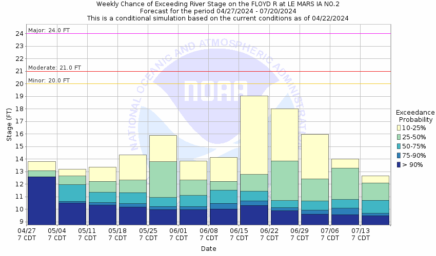
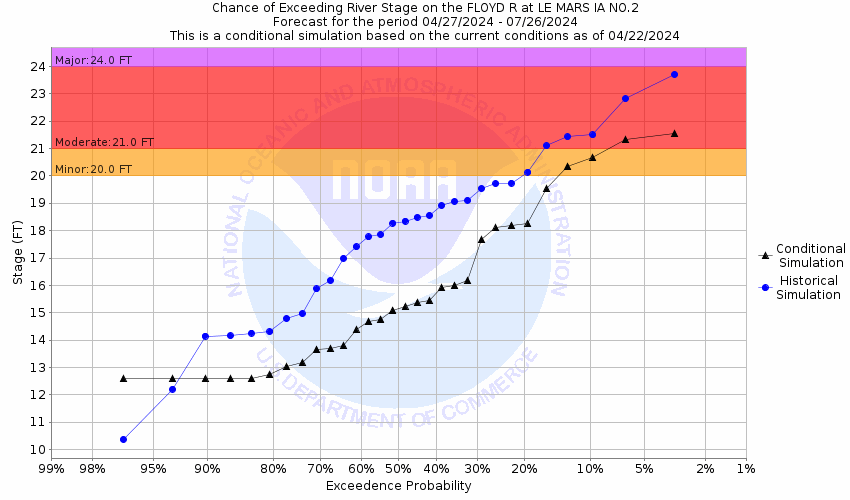
Floyd River At Le Mars (LMRI4)
Return to TopNOTE: River forecasts for this location take into account past precipitation and the precipitation amounts expected approximately 48 hours into the future from the forecast issuance time.
Flood Stage: 20 Feet
Latest Stage: 11.03
Current Warnings/Statements/Advisories:None currently.
NOTE:Forecasts for the Floyd River at Le Mars are issued as needed during times of high water, but are not routinely available.
Flood Categories (in feet)
| Major Flood Stage: |
24 |
| Moderate Flood Stage: |
21 |
| Flood Stage: |
20 |
| Action Stage: |
18 |
| Low Stage (in feet): |
-9999 |
Historic Crests
(1) 26.40 ft on 06/08/1953
(2) 26.40 ft on 09/21/2018
(3) 25.84 ft on 03/14/2019
(4) 24.50 ft on 06/21/1996
(5) 24.40 ft on 04/03/1973
Show More Historic Crests
(P): Preliminary values subject to further review.
Recent Crests
(1) 12.64 ft on 03/23/2023
(2) 13.55 ft on 05/27/2020
(3) 25.84 ft on 03/14/2019
(4) 26.40 ft on 09/21/2018
(5) 20.50 ft on 06/20/2014
Show More Recent Crests
(P): Preliminary values subject to further review.
Low Water Records
Currently none available.
Probabilistic Stage Forecast for Le Mars
Stage Exceedance Forecast for Le Mars
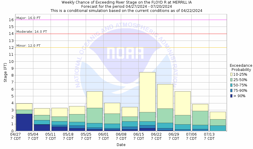
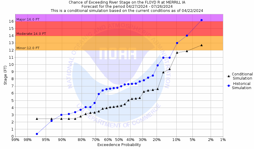
Floyd River At Merrill (MRLI4)
Return to TopNOTE: River forecasts for this location take into account past precipitation and the precipitation amounts expected approximately 48 hours into the future from the forecast issuance time.
Flood Stage: 12 Feet
Latest Stage: 1.99
Current Warnings/Statements/Advisories:None currently.
NOTE:Forecasts for the Floyd River at Merrill are issued as needed during times of high water, but are not routinely available.
Flood Categories (in feet)
| Major Flood Stage: |
16 |
| Moderate Flood Stage: |
14 |
| Flood Stage: |
12 |
| Action Stage: |
10 |
| Low Stage (in feet): |
-9999 |
Historic Crests
(1) 20.00 ft on 09/18/1926
(2) 18.40 ft on 06/07/1934
(3) 18.00 ft on 06/08/1953
(4) 17.60 ft on 03/15/2019
(5) 17.00 ft on 03/24/1979
Show More Historic Crests
(P): Preliminary values subject to further review.
Recent Crests
(1) 3.75 ft on 08/07/2023
(2) 2.19 ft on 06/24/2020
(3) 17.60 ft on 03/15/2019
(4) 17.00 ft on 09/21/2018
(5) 12.20 ft on 07/31/2010
Show More Recent Crests
(P): Preliminary values subject to further review.
Low Water Records
Currently none available.
Probabilistic Stage Forecast for Merrill
Stage Exceedance Forecast for Merrill
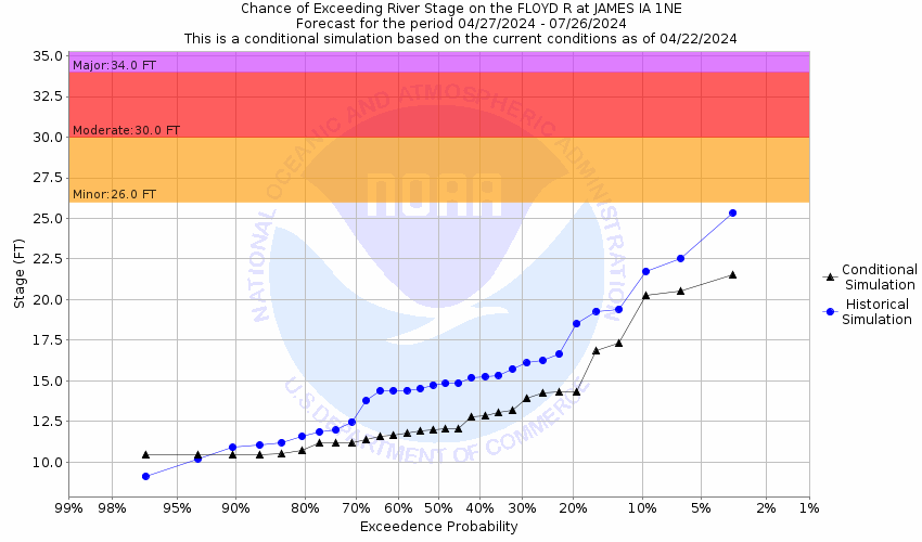
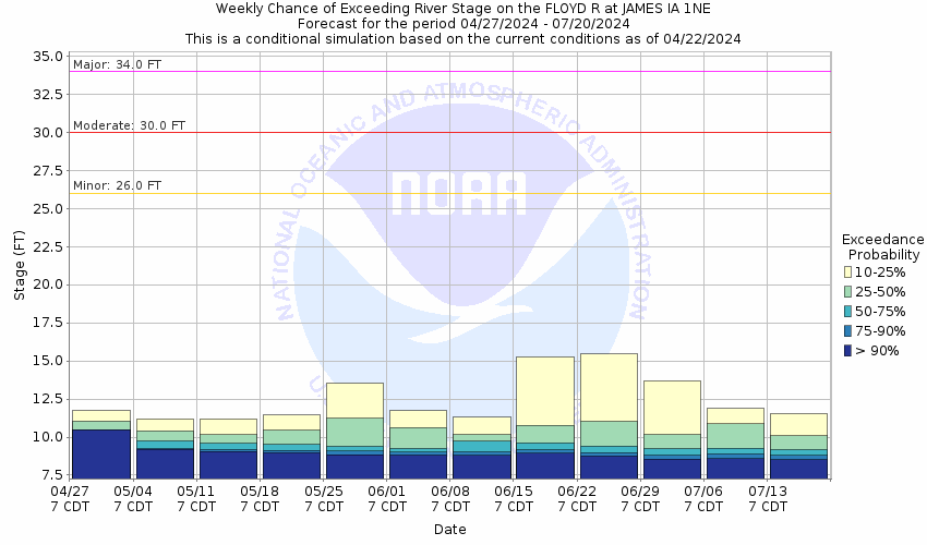
Floyd River At James (JMEI4)
Return to TopNOTE: River forecasts for this location take into account past precipitation and the precipitation amounts expected approximately 48 hours into the future from the forecast issuance time.
Flood Stage: 26 Feet
Latest Stage: 10.19
Current Warnings/Statements/Advisories:None currently.
NOTE:Forecasts for the Floyd River at James are issued as needed during times of high water, but are not routinely available.
Flood Categories (in feet)
| Major Flood Stage: |
34 |
| Moderate Flood Stage: |
30 |
| Flood Stage: |
26 |
| Action Stage: |
24 |
| Low Stage (in feet): |
-9999 |
Historic Crests
(1) 31.48 ft on 03/15/2019
(2) 28.85 ft on 06/21/1983
(3) 28.19 ft on 03/23/1979
(4) 28.13 ft on 02/19/1971
(5) 27.70 ft on 09/22/2018
Show More Historic Crests
(P): Preliminary values subject to further review.
Recent Crests
(1) 13.73 ft on 02/27/2023
(2) 9.13 ft on 04/10/2021
(3) 13.18 ft on 12/30/2019
(4) 31.48 ft on 03/15/2019
(5) 27.70 ft on 09/22/2018
Show More Recent Crests
(P): Preliminary values subject to further review.
Low Water Records
Currently none available.
Probabilistic Stage Forecast for James
Stage Exceedance Forecast for James