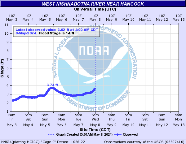
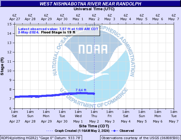
Flood ImpactsIf you notice any errors in the below information, please contact our Webmaster
29
Water reaches the bottom of the bridge deck at the gage site.
24
The top of the berm protecting the lagoons for the city of Hancock are overtopped.
23
Widespread flooding occurs along the reach of the river but Hancock is still safe from the flood waters.
22
The lowland areas of Avoca begin to flood. The degree of flooding also depends on how high the water is on the West Branch which flows along the east side of town.
21
G30 road begins to flood west of Hancock.
19
The lowland areas in Oakland, generally west of Highway 59, begin to flood.
18
Though low-lying areas of the park have already flooded, at this level the majority of the park is underwater.
17
The paved road leading from G30 to Botna Bend Park is flooded.
15.5
The bathroom facility at Botna Bend Park floods.
14
Low-lying areas of Botna Bend Park in Hancock begin to flood. In addition, lowland flooding along the river begins.
Flood Categories (in feet)
| Major Flood Stage: |
23 |
| Moderate Flood Stage: |
19 |
| Flood Stage: |
14 |
| Action Stage: |
12 |
| Low Stage (in feet): |
-9999 |
Historic Crests
(1) 23.52 ft on 07/10/1993
(2) 22.36 ft on 03/14/2019
(3) 22.12 ft on 09/13/1972
(4) 20.53 ft on 05/06/2007
(5) 20.44 ft on 03/01/1965
Show More Historic Crests
(P): Preliminary values subject to further review.
Recent Crests
(1) 5.46 ft on 06/16/2022
(2) 4.42 ft on 03/04/2021
(3) 7.74 ft on 02/18/2020
(4) 22.36 ft on 03/14/2019
(5) 9.12 ft on 08/20/2018
Show More Recent Crests
(P): Preliminary values subject to further review.
Low Water Records
Currently none available.