Flood ImpactsIf you notice any errors in the below information, please contact our Webmaster
26
Water affects the south approach to the Highway 149 bridge.
18
Water affects most agricultural land near Sigourney.
16
Water affects agricultural land, some county roads, and farm houses.
14
Water affects some lower agricultural land along the river.
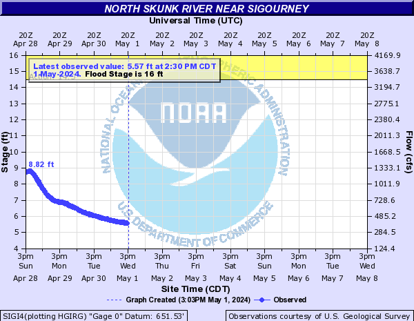
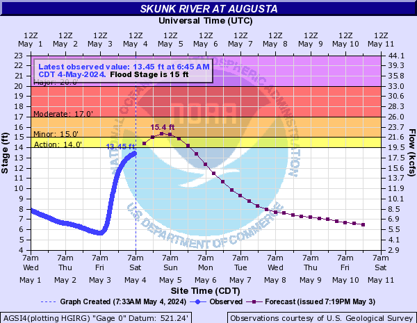
Flood Categories (in feet)
| Major Flood Stage: |
21 |
| Moderate Flood Stage: |
18 |
| Flood Stage: |
16 |
| Action Stage: |
14.5 |
| Low Stage (in feet): |
-9999 |
Historic Crests
(1) 25.93 ft on 05/28/2013
(2) 25.33 ft on 03/31/1960
(3) 25.18 ft on 06/20/1990
(4) 24.68 ft on 07/06/1993
(5) 23.85 ft on 06/14/1966
(6) 23.65 ft on 08/12/2010
(7) 23.27 ft on 04/19/2013
(8) 23.12 ft on 07/03/2014
(P)
(9) 23.01 ft on 03/16/2019
(P)
(10) 22.80 ft on 05/01/1944
Show More Historic Crests
(P): Preliminary values subject to further review.
Recent Crests
(1) 22.76 ft on 05/19/2019
(P)
(2) 23.01 ft on 03/16/2019
(P)
(3) 16.07 ft on 02/24/2019
(P)
(4) 18.50 ft on 11/28/2015
(P)
(5) 18.37 ft on 06/30/2015
(P)
(6) 16.96 ft on 10/15/2014
(P)
(7) 18.93 ft on 09/11/2014
(P)
(8) 23.12 ft on 07/03/2014
(P)
(9) 16.28 ft on 02/21/2014
(P)
(10) 25.93 ft on 05/28/2013
Show More Recent Crests
(P): Preliminary values subject to further review.
Low Water Records
Currently none available.