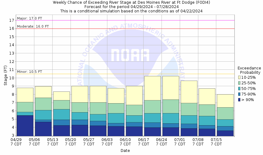
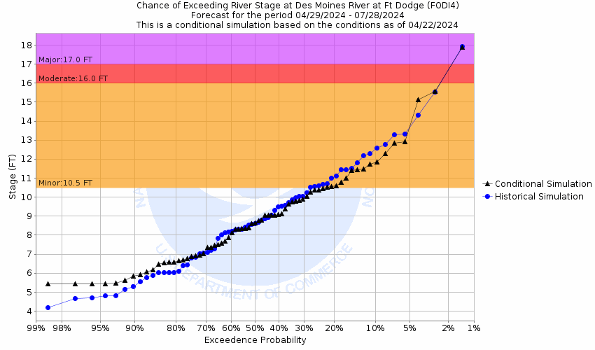
Des Moines River At Fort Dodge (FODI4)
Return to TopNOTE: River forecasts for this location take into account past precipitation and the precipitation amounts expected approximately 24 hours into the future from the forecast issuance time.
Flood Stage: 10.5 Feet
Latest Stage: 4.9
More information on datums is available at
www.ngs.noaa.gov/faq.shtmlNOTE:Forecasts for the Des Moines River at Fort Dodge are issued as needed during times of high water, but are not routinely available.
Flood Categories (in feet)
| Major Flood Stage: |
17 |
| Moderate Flood Stage: |
16 |
| Flood Stage: |
10.5 |
| Action Stage: |
9 |
| Low Stage (in feet): |
-9999 |
Historic Crests
(1) 19.62 ft on 06/23/1947
(2) 19.28 ft on 06/21/1954
(3) 17.79 ft on 04/08/1965
(4) 16.83 ft on 06/27/2010
(5) 15.81 ft on 04/01/1993
(6) 15.73 ft on 06/08/2008
(7) 15.31 ft on 06/19/2014
(8) 15.27 ft on 03/14/2019
(9) 15.04 ft on 03/20/2019
(10) 14.94 ft on 06/19/1984
Show More Historic Crests
(P): Preliminary values subject to further review.
Recent Crests
(1) 8.73 ft on 05/15/2023
(2) 8.58 ft on 06/16/2022
(3) 0.00 ft on 03/29/2021
(4) 0.00 ft on 03/21/2020
(5) 15.04 ft on 03/20/2019
(6) 15.27 ft on 03/14/2019
(7) 14.14 ft on 09/23/2018
(8) 14.61 ft on 03/05/2018
(9) 9.68 ft on 05/22/2017
(10) 10.21 ft on 12/18/2016
Show More Recent Crests
(P): Preliminary values subject to further review.
Low Water Records
Currently none available.
Probabilistic Stage Forecast for Fort Dodge
Stage Exceedance Forecast for Fort Dodge
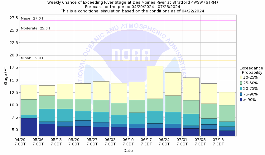
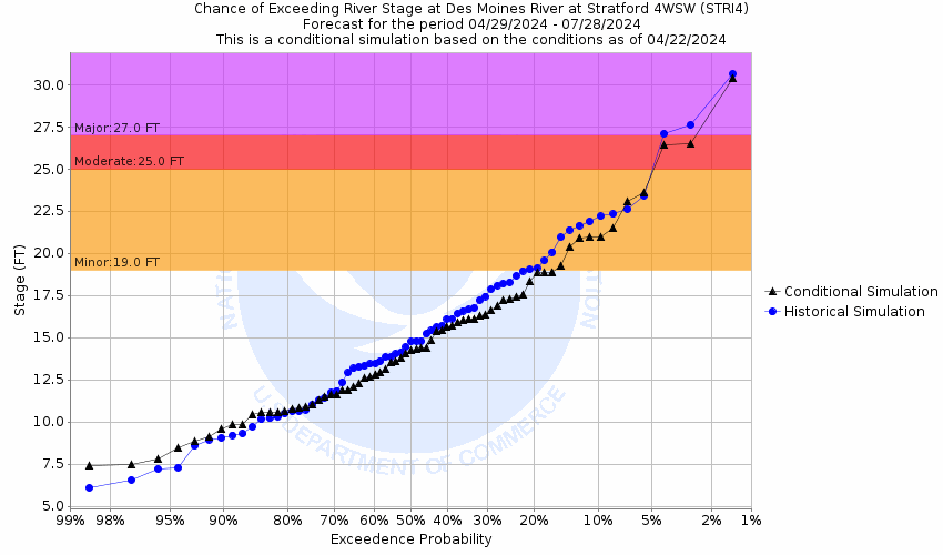
Des Moines River Near Stratford (STRI4)
Return to TopNOTE: River forecasts for this location take into account past precipitation and the precipitation amounts expected approximately 24 hours into the future from the forecast issuance time.
Flood Stage: 19 Feet
Latest Stage: 6.81
More information on datums is available at
www.ngs.noaa.gov/faq.shtmlNOTE:Forecasts for the Des Moines River near Stratford are issued as needed during times of high water, but are not routinely available.
Flood Categories (in feet)
| Major Flood Stage: |
27 |
| Moderate Flood Stage: |
25 |
| Flood Stage: |
19 |
| Action Stage: |
14 |
| Low Stage (in feet): |
-9999 |
Historic Crests
(1) 28.42 ft on 06/28/2010
(2) 27.32 ft on 06/09/2008
(3) 25.68 ft on 04/02/1993
(4) 24.08 ft on 06/19/1984
(5) 23.31 ft on 06/05/1991
(6) 23.22 ft on 08/26/1979
(7) 23.08 ft on 09/24/2018
(8) 22.89 ft on 08/23/2007
(9) 22.57 ft on 06/20/2014
(10) 22.26 ft on 03/18/2019
Show More Historic Crests
(P): Preliminary values subject to further review.
Recent Crests
(1) 13.94 ft on 05/16/2023
(2) 10.78 ft on 06/17/2022
(3) 0.00 ft on 05/23/2021
(4) 15.90 ft on 03/21/2020
(5) 22.12 ft on 03/21/2019
(6) 22.26 ft on 03/18/2019
(7) 23.08 ft on 09/24/2018
(8) 19.02 ft on 12/16/2015
(9) 17.52 ft on 08/28/2015
(10) 22.57 ft on 06/20/2014
Show More Recent Crests
(P): Preliminary values subject to further review.
Low Water Records
Currently none available.
Probabilistic Stage Forecast for Stratford
Stage Exceedance Forecast for Stratford
Des Moines River At Saylorville Reservoir (SAYI4)
Return to TopFlood Stage: 884 Feet
Latest Stage: 836.78
More information on datums is available at
www.ngs.noaa.gov/faq.shtmlNOTE:Forecasts are not available for the Des Moines River at Saylorville Reservoir. Only observed stages are available for this point.
Flood Categories (in feet)
| Major Flood Stage: |
0 |
| Moderate Flood Stage: |
0 |
| Flood Stage: |
884 |
| Action Stage: |
0 |
| Low Stage (in feet): |
-9999 |
Historic Crests
(1) 892.03 ft on 07/11/1993
(2) 891.03 ft on 06/12/2008
(3) 889.25 ft on 06/22/1984
(4) 889.15 ft on 07/01/2010
(5) 888.99 ft on 06/11/1991
(6) 886.19 ft on 07/09/2018
(7) 883.59 ft on 04/06/1979
(P)
(8) 881.20 ft on 04/22/1983
(9) 880.52 ft on 03/30/2019
(10) 878.91 ft on 05/14/2001
(P)
Show More Historic Crests
(P): Preliminary values subject to further review.
Recent Crests
(1) 837.66 ft on 03/02/2023
(P)
(2) 839.17 ft on 12/26/2021
(P)
(3) 838.59 ft on 12/24/2020
(P)
(4) 844.39 ft on 06/01/2020
(P)
(5) 880.52 ft on 03/30/2019
(6) 886.19 ft on 07/09/2018
(7) 850.39 ft on 10/01/2016
(P)
(8) 865.83 ft on 12/22/2015
(P)
(9) 845.47 ft on 06/29/2015
(P)
(10) 877.57 ft on 07/06/2014
(P)
Show More Recent Crests
(P): Preliminary values subject to further review.
Low Water Records (1) 829.27 ft on 03/08/2013
(2) 831.57 ft on 01/02/2023
(3) 832.23 ft on 03/09/1989
(4) 832.41 ft on 03/03/1979
(5) 832.53 ft on 03/09/2014
Show More Low Water Records Des Moines River At Saylorville Tail (SDTI4)
Return to TopFlood Stage: Not available
Latest Stage: 5
More information on datums is available at
www.ngs.noaa.gov/faq.shtmlNOTE:Forecasts are not available for the Des Moines River at Saylorville Tail. Only observed stages are available for this point.
Flood Categories (in feet)
Historic Crests
(1) 24.50 ft on 06/24/1954
(2) 24.22 ft on 07/11/1993
(3) 24.03 ft on 06/13/2008
(4) 24.02 ft on 04/10/1965
(5) 22.90 ft on 07/21/1993
(6) 21.10 ft on 04/03/1962
(7) 20.88 ft on 07/02/2010
(8) 20.72 ft on 06/22/1984
(9) 20.65 ft on 07/01/2010
(10) 20.15 ft on 04/18/1969
Show More Historic Crests
(P): Preliminary values subject to further review.
Recent Crests
(1) 11.60 ft on 05/18/2023
(2) 11.87 ft on 03/01/2023
(3) 10.39 ft on 06/17/2022
(4) 5.68 ft on 03/27/2021
(5) 0.00 ft on 10/13/2019
(6) 15.47 ft on 03/30/2019
(7) 17.20 ft on 07/01/2018
(8) 15.51 ft on 10/01/2016
(9) 15.64 ft on 09/28/2016
(10) 13.31 ft on 12/23/2015
Show More Recent Crests
(P): Preliminary values subject to further review.
Low Water Records
Currently none available.
Des Moines River At Des Moines 2nd Ave (DMOI4)
Return to TopNOTE: River forecasts for this location take into account past precipitation and the precipitation amounts expected approximately 24 hours into the future from the forecast issuance time.
Flood Stage: 23 Feet
Latest Stage: 16.27
More information on datums is available at
www.ngs.noaa.gov/faq.shtmlNOTE:Forecasts for the Des Moines River at Des Moines 2nd Ave are issued as needed during times of high water, but are not routinely available.
Flood Categories (in feet)
| Major Flood Stage: |
30 |
| Moderate Flood Stage: |
26 |
| Flood Stage: |
23 |
| Action Stage: |
19 |
| Low Stage (in feet): |
-9999 |
Historic Crests
(1) 31.57 ft on 06/13/2008
(2) 30.16 ft on 06/24/1954
(3) 27.30 ft on 05/31/1903
(4) 26.50 ft on 06/26/1947
(5) 26.08 ft on 07/02/2010
(6) 25.25 ft on 04/01/1960
(7) 24.40 ft on 05/23/1944
(8) 24.00 ft on 07/01/2018
(9) 23.80 ft on 03/31/1951
(10) 22.55 ft on 03/31/1961
Show More Historic Crests
(P): Preliminary values subject to further review.
Recent Crests
(1) 19.88 ft on 03/01/2023
(2) 18.23 ft on 06/17/2022
(3) 14.41 ft on 03/27/2021
(4) 16.40 ft on 03/23/2021
(5) 19.37 ft on 05/28/2020
(6) 20.49 ft on 10/12/2019
(7) 21.61 ft on 03/22/2019
(8) 21.20 ft on 10/12/2018
(9) 24.00 ft on 07/01/2018
(10) 20.29 ft on 10/01/2016
Show More Recent Crests
(P): Preliminary values subject to further review.
Low Water Records
Currently none available.
Probabilistic Stage Forecast for Des Moines 2nd Ave
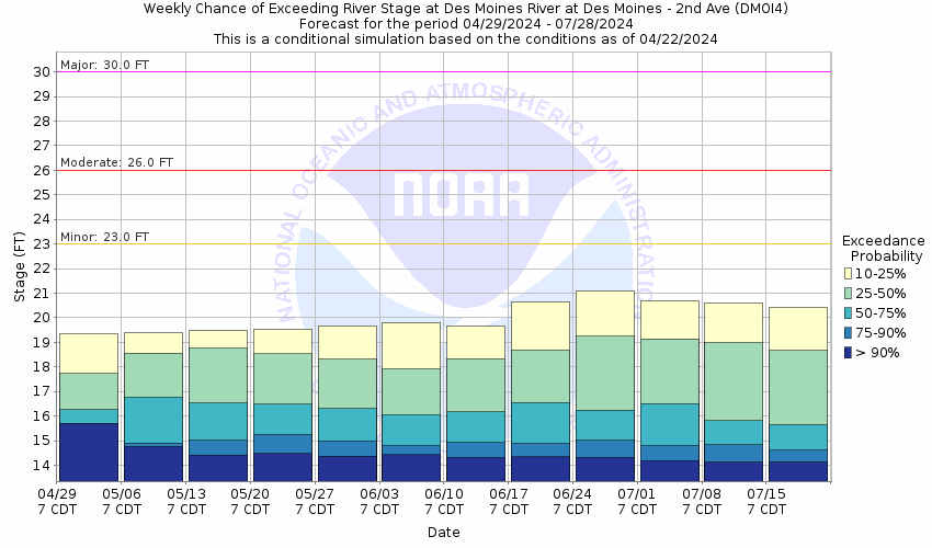
Stage Exceedance Forecast for Des Moines 2nd Ave

Des Moines River At Des Moines SE 6th St (DESI4)
Return to TopNOTE: River forecasts for this location take into account past precipitation and the precipitation amounts expected approximately 24 hours into the future from the forecast issuance time.
Flood Stage: 24 Feet
Latest Stage: 12.27
More information on datums is available at
www.ngs.noaa.gov/faq.shtmlNOTE:Forecasts for the Des Moines River at Des Moines SE 6th St are issued as needed during times of high water, but are not routinely available.
Flood Categories (in feet)
| Major Flood Stage: |
30 |
| Moderate Flood Stage: |
26 |
| Flood Stage: |
24 |
| Action Stage: |
20 |
| Low Stage (in feet): |
-9999 |
Historic Crests
(1) 35.55 ft on 06/13/2008
(2) 34.29 ft on 07/11/1993
(3) 30.14 ft on 06/26/2015
(4) 29.83 ft on 07/02/2010
(5) 29.78 ft on 04/11/1965
(6) 29.16 ft on 03/16/2019
(7) 28.87 ft on 07/01/2018
(8) 28.86 ft on 04/02/1960
(9) 28.65 ft on 06/16/1998
(10) 28.46 ft on 06/19/1984
Show More Historic Crests
(P): Preliminary values subject to further review.
Recent Crests
(1) 21.70 ft on 03/01/2023
(2) 22.42 ft on 06/07/2022
(3) 13.54 ft on 03/27/2021
(4) 23.58 ft on 10/12/2019
(5) 29.16 ft on 03/16/2019
(6) 28.87 ft on 07/01/2018
(7) 24.15 ft on 05/24/2017
(8) 26.93 ft on 12/15/2015
(9) 30.14 ft on 06/26/2015
(10) 25.97 ft on 07/01/2014
Show More Recent Crests
(P): Preliminary values subject to further review.
Low Water Records
Currently none available.
Probabilistic Stage Forecast for Des Moines SE 6th St
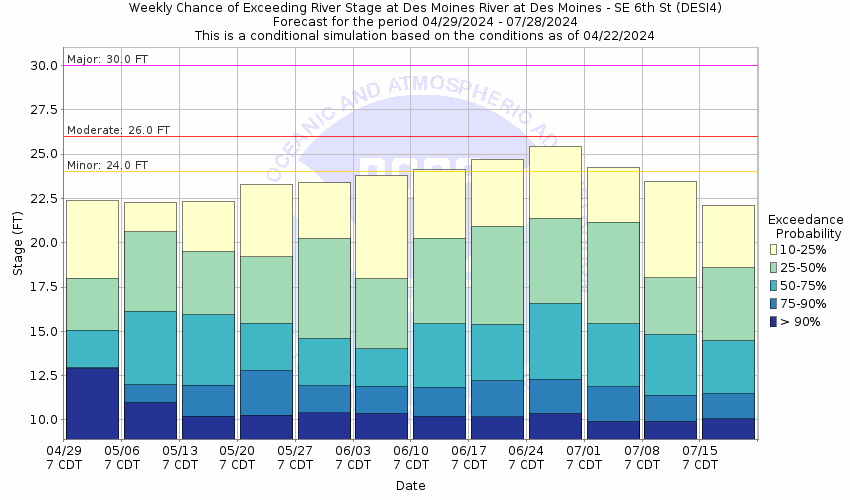
Stage Exceedance Forecast for Des Moines SE 6th St

Des Moines River Near Swan (SWNI4)
Return to TopFlood Stage: Not available
Latest Stage: 44.65
More information on datums is available at
www.ngs.noaa.gov/faq.shtmlNOTE:Forecasts are not available for the Des Moines River near Swan. Only observed stages are available for this point.
Flood Categories (in feet)
Historic Crests
(1) 79.26 ft on 07/05/2010
(2) 76.39 ft on 06/28/2011
(3) 75.72 ft on 05/31/2019
(4) 70.57 ft on 07/01/2015
(5) 67.76 ft on 06/27/2015
(6) 67.27 ft on 06/20/2013
(7) 67.18 ft on 07/10/2014
(8) 66.73 ft on 07/19/2018
(9) 63.61 ft on 12/26/2015
(10) 62.56 ft on 07/03/2018
Show More Historic Crests
(P): Preliminary values subject to further review.
Recent Crests
(1) 51.14 ft on 03/02/2023
(2) 52.52 ft on 06/09/2022
(3) 0.00 ft on 07/11/2021
(4) 54.17 ft on 10/14/2019
(5) 75.72 ft on 05/31/2019
(6) 66.73 ft on 07/19/2018
(7) 62.56 ft on 07/03/2018
(8) 53.36 ft on 05/25/2017
(9) 52.74 ft on 04/06/2017
(10) 63.61 ft on 12/26/2015
Show More Recent Crests
(P): Preliminary values subject to further review.
Low Water Records
Currently none available.
Des Moines River At Red Rock Reservoir (PELI4)
Return to TopFlood Stage: 780 Feet
Latest Stage: 742.16
More information on datums is available at
www.ngs.noaa.gov/faq.shtmlNOTE:Forecasts are not available for the Des Moines River at Red Rock Reservoir. Only observed stages are available for this point.
Flood Categories (in feet)
| Major Flood Stage: |
0 |
| Moderate Flood Stage: |
0 |
| Flood Stage: |
780 |
| Action Stage: |
0 |
| Low Stage (in feet): |
-9999 |
Historic Crests
(1) 782.67 ft on 07/13/1993
(2) 779.61 ft on 06/25/1984
(P)
(3) 779.32 ft on 06/21/1991
(4) 779.10 ft on 06/14/2008
(5) 778.81 ft on 07/05/2010
(P)
(6) 777.95 ft on 05/14/1973
(7) 775.84 ft on 06/29/2011
(P)
(8) 774.92 ft on 05/31/2019
(P)
(9) 774.00 ft on 05/29/1983
(P)
(10) 769.96 ft on 07/02/2015
(P)
Show More Historic Crests
(P): Preliminary values subject to further review.
Recent Crests
(1) 744.37 ft on 12/15/2022
(P)
(2) 747.28 ft on 12/30/2021
(P)
(3) 745.81 ft on 12/24/2020
(P)
(4) 752.79 ft on 10/16/2019
(P)
(5) 774.92 ft on 05/31/2019
(P)
(6) 766.21 ft on 07/20/2018
(P)
(7) 751.37 ft on 05/31/2017
(P)
(8) 762.46 ft on 12/27/2015
(P)
(9) 769.96 ft on 07/02/2015
(P)
(10) 766.66 ft on 07/11/2014
(P)
Show More Recent Crests
(P): Preliminary values subject to further review.
Low Water Records (1) 719.68 ft on 02/18/1977
(2) 721.92 ft on 01/01/1974
(3) 722.73 ft on 01/15/1975
(4) 722.81 ft on 12/28/1972
(5) 724.57 ft on 11/19/1970
Show More Low Water Records Des Moines River At Red Rock Tail (RRDI4)
Return to TopFlood Stage: Not available
Latest Stage: 85.99
More information on datums is available at
www.ngs.noaa.gov/faq.shtmlNOTE:Forecasts are not available for the Des Moines River at Red Rock Tail. Only observed stages are available for this point.
Flood Categories (in feet)
Historic Crests
(1) 109.71 ft on 07/12/1993
(2) 108.96 ft on 06/14/2008
(3) 101.24 ft on 07/06/2010
(4) 99.43 ft on 06/06/2019
(5) 97.64 ft on 10/01/1993
(6) 97.31 ft on 04/20/1999
(7) 96.92 ft on 04/20/1998
(8) 96.44 ft on 03/19/2007
(9) 96.39 ft on 07/20/2011
(10) 96.37 ft on 04/14/2001
Show More Historic Crests
(P): Preliminary values subject to further review.
Recent Crests
(1) 94.47 ft on 03/02/2023
(2) 92.49 ft on 06/09/2022
(3) 90.93 ft on 07/12/2021
(4) 94.71 ft on 03/26/2020
(5) 99.43 ft on 06/06/2019
(6) 93.68 ft on 08/10/2018
(7) 94.90 ft on 04/01/2017
(8) 96.37 ft on 01/10/2016
(9) 93.86 ft on 06/29/2015
(10) 93.77 ft on 07/13/2014
Show More Recent Crests
(P): Preliminary values subject to further review.
Low Water Records
Currently none available.
Des Moines River Near Tracy (TRCI4)
Return to TopFlood Stage: 14 Feet
Latest Stage: 3.81
More information on datums is available at
www.ngs.noaa.gov/faq.shtmlNOTE:Forecasts are not available for the Des Moines River near Tracy. Only observed stages are available for this point.
Flood Categories (in feet)
| Major Flood Stage: |
23 |
| Moderate Flood Stage: |
20 |
| Flood Stage: |
14 |
| Action Stage: |
13 |
| Low Stage (in feet): |
-9999 |
Historic Crests
(1) 26.50 ft on 06/14/1947
(2) 25.00 ft on 05/31/1903
(3) 24.16 ft on 07/12/1993
(4) 23.70 ft on 06/14/2008
(5) 23.17 ft on 04/11/1965
(6) 23.00 ft on 04/04/1960
(7) 22.14 ft on 06/27/1954
(8) 21.60 ft on 05/23/1944
(9) 20.69 ft on 04/05/1962
(10) 20.38 ft on 06/17/1967
Show More Historic Crests
(P): Preliminary values subject to further review.
Recent Crests
(1) 10.35 ft on 03/02/2023
(2) 8.73 ft on 06/08/2022
(3) 7.39 ft on 07/11/2021
(4) 10.66 ft on 03/25/2020
(5) 15.18 ft on 06/06/2019
(6) 9.76 ft on 05/22/2018
(7) 11.27 ft on 04/05/2017
(8) 13.01 ft on 12/24/2015
(9) 13.20 ft on 06/26/2015
(10) 10.23 ft on 07/13/2014
Show More Recent Crests
(P): Preliminary values subject to further review.
Low Water Records
Currently none available.
Des Moines River Near Eddyville (EDYI4)
Return to TopNOTE: River forecasts for this location take into account past precipitation and the precipitation amounts expected approximately 24 hours into the future from the forecast issuance time.
Flood Stage: 63 Feet
Latest Stage: 49.75
More information on datums is available at
www.ngs.noaa.gov/faq.shtmlNOTE:Forecasts for the Des Moines River near Eddyville are issued as needed during times of high water, but are not routinely available.
Flood Categories (in feet)
| Major Flood Stage: |
70 |
| Moderate Flood Stage: |
68 |
| Flood Stage: |
63 |
| Action Stage: |
60 |
| Low Stage (in feet): |
-9999 |
Historic Crests
(1) 71.99 ft on 07/12/1993
(P)
(2) 71.87 ft on 06/16/2008
(P)
(3) 68.92 ft on 02/23/2015
(P)
(4) 68.68 ft on 08/11/2010
(P)
(5) 66.64 ft on 06/26/1984
(6) 65.94 ft on 05/02/1999
(P)
(7) 65.49 ft on 05/30/2019
(P)
(8) 64.90 ft on 04/19/1991
(P)
(9) 64.24 ft on 04/19/2013
(P)
(10) 63.93 ft on 04/04/1998
(P)
Show More Historic Crests
(P): Preliminary values subject to further review.
Recent Crests
(1) 59.58 ft on 03/02/2023
(2) 57.40 ft on 06/09/2022
(3) 56.03 ft on 07/12/2021
(P)
(4) 60.07 ft on 03/28/2020
(P)
(5) 65.49 ft on 05/30/2019
(P)
(6) 58.60 ft on 05/03/2018
(P)
(7) 61.58 ft on 04/06/2017
(P)
(8) 62.67 ft on 12/14/2015
(P)
(9) 68.92 ft on 02/23/2015
(P)
(10) 60.50 ft on 09/10/2014
(P)
Show More Recent Crests
(P): Preliminary values subject to further review.
Low Water Records (1) 46.43 ft on 02/17/2021
(2) 46.54 ft on 07/08/2015
(3) 46.95 ft on 05/20/2020
(4) 46.96 ft on 01/31/2019
(5) 47.17 ft on 12/25/2012
Show More Low Water Records
Probabilistic Stage Forecast for Eddyville
Stage Exceedance Forecast for Eddyville

Des Moines River At Ottumwa (OTMI4)
Return to TopNOTE: River forecasts for this location take into account past precipitation and the precipitation amounts expected approximately 24 hours into the future from the forecast issuance time.
Flood Stage: 11.5 Feet
Latest Stage: 2.74
More information on datums is available at
www.ngs.noaa.gov/faq.shtmlNOTE:Forecasts for the Des Moines River at Ottumwa are issued as needed during times of high water, but are not routinely available.
Flood Categories (in feet)
| Major Flood Stage: |
19 |
| Moderate Flood Stage: |
15 |
| Flood Stage: |
11.5 |
| Action Stage: |
9 |
| Low Stage (in feet): |
-9999 |
Historic Crests
(1) 22.15 ft on 07/12/1993
(2) 20.60 ft on 06/17/2008
(3) 20.20 ft on 06/07/1947
(4) 20.04 ft on 08/11/2010
(5) 19.40 ft on 05/31/1903
(6) 18.33 ft on 04/11/1965
(7) 17.50 ft on 05/24/1944
(8) 17.49 ft on 04/01/1960
(9) 16.89 ft on 06/28/1954
(10) 16.80 ft on 06/10/1917
Show More Historic Crests
(P): Preliminary values subject to further review.
Recent Crests
(1) 10.00 ft on 03/02/2023
(2) 8.86 ft on 06/09/2022
(3) 9.04 ft on 02/28/2021
(4) 11.30 ft on 03/28/2020
(5) 16.28 ft on 05/29/2019
(6) 8.96 ft on 09/06/2018
(7) 12.03 ft on 04/05/2017
(8) 12.61 ft on 12/14/2015
(9) 13.74 ft on 06/26/2015
(10) 12.17 ft on 09/10/2014
Show More Recent Crests
(P): Preliminary values subject to further review.
Low Water Records
Currently none available.
Probabilistic Stage Forecast for Ottumwa
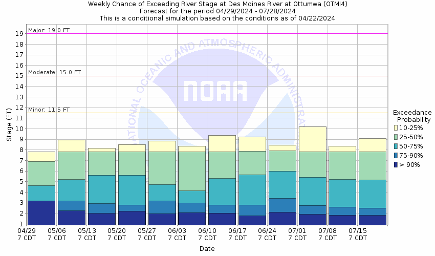
Stage Exceedance Forecast for Ottumwa

Des Moines River At Keosauqua (KEQI4)
Return to TopNOTE: River forecasts for this location take into account past precipitation and the precipitation amounts expected approximately 24 hours into the future from the forecast issuance time.
Flood Stage: 22 Feet
Latest Stage: 11.57
Current Warnings/Statements/Advisories:None currently.
NOTE:Forecasts for the Des Moines River at Keosauqua are issued routinely during the warm season, and as needed at other times of the year.
Flood Categories (in feet)
| Major Flood Stage: |
27 |
| Moderate Flood Stage: |
25 |
| Flood Stage: |
22 |
| Action Stage: |
21 |
| Low Stage (in feet): |
-9999 |
Historic Crests
(1) 32.66 ft on 07/13/1993
(2) 30.49 ft on 06/16/2008
(3) 28.18 ft on 08/12/2010
(4) 28.02 ft on 04/21/1973
(5) 27.88 ft on 05/29/2019
(6) 27.85 ft on 06/01/1903
(7) 27.23 ft on 04/24/1976
(8) 27.14 ft on 07/17/1982
(9) 27.12 ft on 04/18/2013
(10) 26.39 ft on 05/17/1986
Show More Historic Crests
(P): Preliminary values subject to further review.
Recent Crests
(1) 19.63 ft on 06/10/2020
(2) 27.88 ft on 05/29/2019
(3) 19.11 ft on 09/06/2018
(4) 21.29 ft on 04/06/2017
(5) 22.81 ft on 12/14/2015
(6) 23.22 ft on 06/26/2015
(7) 21.60 ft on 09/10/2014
(8) 27.12 ft on 04/18/2013
(9) 16.48 ft on 04/19/2012
(10) 25.11 ft on 06/15/2011
Show More Recent Crests
(P): Preliminary values subject to further review.
Low Water Records
Currently none available.
Probabilistic Stage Forecast for Keosauqua
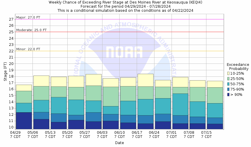
Stage Exceedance Forecast for Keosauqua

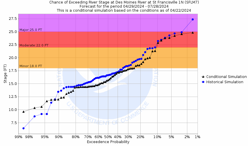
Des Moines River At St. Francisville (SFLM7)
Return to TopNOTE: River forecasts for this location take into account past precipitation and the precipitation amounts expected approximately 24 hours into the future from the forecast issuance time.
Flood Stage: 18 Feet
Latest Stage: 8.71
Current Warnings/Statements/Advisories:None currently.
NOTE:Forecasts for the Des Moines River at St. Francisville are issued as needed during times of high water, but are not routinely available.
Flood Categories (in feet)
| Major Flood Stage: |
25 |
| Moderate Flood Stage: |
22 |
| Flood Stage: |
18 |
| Action Stage: |
17 |
| Low Stage (in feet): |
-9999 |
Historic Crests
(1) 32.02 ft on 07/15/1993
(2) 30.15 ft on 03/14/1979
(3) 28.22 ft on 01/19/1973
(4) 28.21 ft on 06/17/2008
(5) 27.86 ft on 05/29/2019
(P)
(6) 27.55 ft on 06/09/1947
(7) 26.55 ft on 04/19/2013
(P)
(8) 26.30 ft on 05/18/1986
(9) 26.27 ft on 04/24/1976
(10) 26.15 ft on 04/12/1965
Show More Historic Crests
(P): Preliminary values subject to further review.
Recent Crests
(1) 18.55 ft on 06/10/2020
(P)
(2) 27.86 ft on 05/29/2019
(P)
(3) 19.22 ft on 05/23/2019
(P)
(4) 20.39 ft on 05/20/2019
(P)
(5) 18.50 ft on 03/14/2019
(P)
(6) 21.95 ft on 02/04/2019
(P)
(7) 19.29 ft on 01/09/2016
(P)
(8) 18.06 ft on 12/28/2015
(P)
(9) 19.11 ft on 12/25/2015
(P)
(10) 18.64 ft on 12/22/2015
(P)
Show More Recent Crests
(P): Preliminary values subject to further review.
Low Water Records
Currently none available.
Probabilistic Stage Forecast for St. Francisville
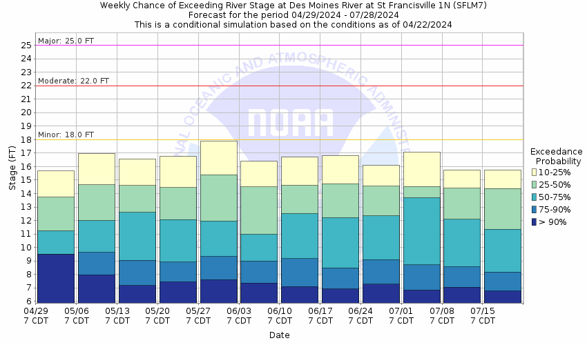
Stage Exceedance Forecast for St. Francisville