Mississippi River Below Lock and Dam 10 - Guttenberg (GTTI4)
Return to TopNOTE: River forecasts for this location take into account past precipitation and the precipitation amounts expected approximately 24 hours into the future from the forecast issuance time.
Flood Stage: 15 Feet
Latest Stage: 8.07
Current Warnings/Statements/Advisories:None currently.
Vertical Datum is the USACE 1912 datum
Flood Categories (in feet)
| Major Flood Stage: |
21 |
| Moderate Flood Stage: |
18 |
| Flood Stage: |
15 |
| Action Stage: |
12 |
| Low Stage (in feet): |
-9999 |
Historic Crests
(1) 23.65 ft on 04/24/1965
(2) 21.68 ft on 04/21/2001
(3) 20.98 ft on 04/28/2023
(P)
(4) 20.15 ft on 06/30/1993
(5) 19.98 ft on 04/27/2019
Show More Historic Crests
(P): Preliminary values subject to further review.
Recent Crests
(1) 20.98 ft on 04/28/2023
(P)
(2) 15.26 ft on 10/13/2019
(P)
(3) 17.59 ft on 05/31/2019
(4) 19.98 ft on 04/27/2019
(5) 16.14 ft on 05/28/2017
Show More Recent Crests
(P): Preliminary values subject to further review.
Mississippi River At Dubuque (LD11) (DLDI4)
Return to TopNOTE: River forecasts for this location take into account past precipitation and the precipitation amounts expected approximately 24 hours into the future from the forecast issuance time.
Flood Stage: 16 Feet
Latest Stage: 7.68
Current Warnings/Statements/Advisories:None currently.
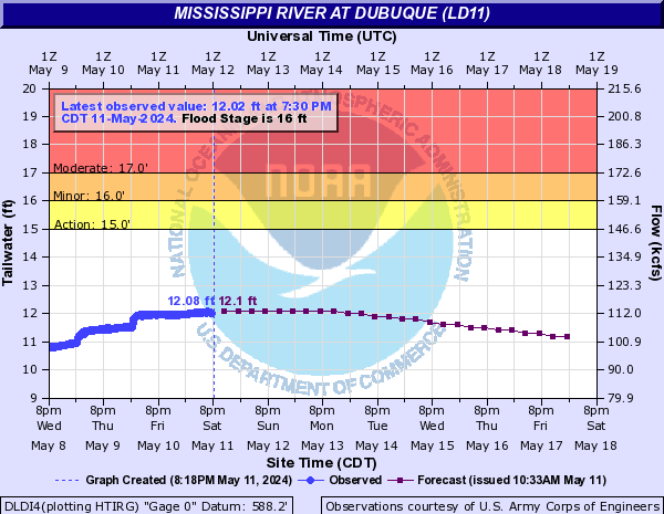
Flood Categories (in feet)
| Major Flood Stage: |
20.5 |
| Moderate Flood Stage: |
17 |
| Flood Stage: |
16 |
| Action Stage: |
15 |
| Low Stage (in feet): |
-9999 |
Historic Crests
(1) 25.69 ft on 04/26/1965
(2) 23.91 ft on 04/21/2001
(3) 23.03 ft on 04/29/2023
(P)
(4) 22.32 ft on 07/01/1993
(5) 21.77 ft on 04/27/2019
(6) 21.74 ft on 04/23/1969
(7) 21.64 ft on 04/22/1951
(8) 21.57 ft on 04/25/1952
(9) 21.32 ft on 05/06/1975
(10) 21.24 ft on 04/19/2011
Show More Historic Crests
(P): Preliminary values subject to further review.
Recent Crests
(1) 23.03 ft on 04/29/2023
(P)
(2) 19.19 ft on 05/31/2019
(P)
(3) 21.77 ft on 04/27/2019
(4) 21.22 ft on 04/06/2019
(P)
(5) 17.87 ft on 05/07/2018
(6) 17.04 ft on 05/29/2017
(7) 15.91 ft on 09/30/2016
(8) 11.23 ft on 06/06/2015
(9) 18.46 ft on 07/04/2014
(10) 16.30 ft on 06/26/2013
Show More Recent Crests
(P): Preliminary values subject to further review.
Low Water Records
Currently none available.
Mississippi River At Dubuque (Railroad Bridge) (DBQI4)
Return to TopNOTE: River forecasts for this location take into account past precipitation and the precipitation amounts expected approximately 24 hours into the future from the forecast issuance time.
Flood Stage: 17 Feet
Latest Stage: 9.99
Current Warnings/Statements/Advisories:None currently.
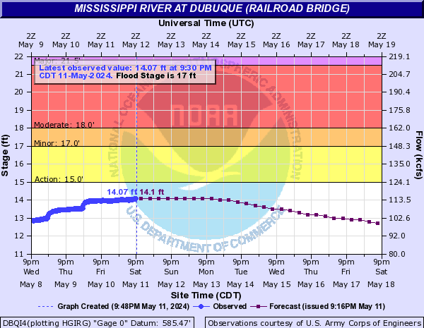
Flood Categories (in feet)
| Major Flood Stage: |
21.5 |
| Moderate Flood Stage: |
18 |
| Flood Stage: |
17 |
| Action Stage: |
15 |
| Low Stage (in feet): |
-9999 |
Historic Crests
(1) 26.81 ft on 04/26/1965
(2) 25.40 ft on 04/21/2001
(3) 24.30 ft on 04/29/2023
(P)
(4) 23.84 ft on 07/01/1993
(5) 23.18 ft on 04/27/2019
(6) 23.11 ft on 04/23/1969
(7) 22.82 ft on 04/19/2011
(8) 22.80 ft on 04/16/1997
(9) 22.78 ft on 05/06/1975
(10) 22.70 ft on 04/25/1952
Show More Historic Crests
(P): Preliminary values subject to further review.
Recent Crests
(1) 24.30 ft on 04/29/2023
(P)
(2) 20.75 ft on 05/31/2019
(P)
(3) 23.18 ft on 04/27/2019
(4) 22.65 ft on 04/06/2019
(P)
(5) 19.66 ft on 05/08/2018
(6) 18.80 ft on 05/29/2017
(7) 17.78 ft on 09/30/2016
(8) 17.23 ft on 03/26/2016
(9) 13.31 ft on 06/06/2015
(10) 20.24 ft on 07/03/2014
Show More Recent Crests
(P): Preliminary values subject to further review.
Low Water Records
Currently none available.
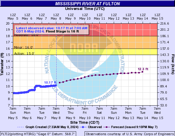
Mississippi River At Fulton (FLTI2)
Return to TopNOTE: River forecasts for this location take into account past precipitation and the precipitation amounts expected approximately 24 hours into the future from the forecast issuance time.
Flood Stage: 16 Feet
Latest Stage: 7.6
Current Warnings/Statements/Advisories:None currently.
Flood Categories (in feet)
| Major Flood Stage: |
20 |
| Moderate Flood Stage: |
18 |
| Flood Stage: |
16 |
| Action Stage: |
15 |
| Low Stage (in feet): |
-9999 |
Historic Crests
(1) 24.75 ft on 04/28/1965
(2) 23.31 ft on 04/24/2001
(3) 22.17 ft on 07/08/1993
(4) 22.06 ft on 04/30/2023
(P)
(5) 21.77 ft on 04/30/2019
(6) 21.37 ft on 04/26/1969
(7) 21.23 ft on 04/27/1952
(8) 21.06 ft on 04/21/2011
(9) 21.00 ft on 04/26/1951
(10) 20.91 ft on 04/08/2019
(P)
Show More Historic Crests
(P): Preliminary values subject to further review.
Recent Crests
(1) 22.06 ft on 04/30/2023
(P)
(2) 19.83 ft on 06/05/2019
(P)
(3) 21.77 ft on 04/30/2019
(4) 20.91 ft on 04/08/2019
(P)
(5) 17.61 ft on 05/10/2018
(6) 16.69 ft on 05/31/2017
(7) 15.93 ft on 09/30/2016
(8) 12.03 ft on 06/16/2015
(9) 19.27 ft on 07/03/2014
(10) 16.92 ft on 04/20/2013
Show More Recent Crests
(P): Preliminary values subject to further review.
Low Water Records
Currently none available.
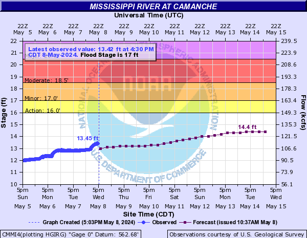
Mississippi River At Camanche (CMMI4)
Return to TopNOTE: River forecasts for this location take into account past precipitation and the precipitation amounts expected approximately 24 hours into the future from the forecast issuance time.
Flood Stage: 17 Feet
Latest Stage: 11.15
Current Warnings/Statements/Advisories:None currently.
Flood Categories (in feet)
| Major Flood Stage: |
20.5 |
| Moderate Flood Stage: |
18.5 |
| Flood Stage: |
17 |
| Action Stage: |
16 |
| Low Stage (in feet): |
-9999 |
Historic Crests
(1) 24.65 ft on 04/28/1965
(2) 23.62 ft on 04/24/2001
(3) 23.55 ft on 04/23/2001
(4) 22.98 ft on 07/08/1993
(5) 22.87 ft on 07/07/1993
(6) 22.86 ft on 04/30/2023
(P)
(7) 22.77 ft on 05/01/2019
(8) 22.65 ft on 04/30/2019
(9) 21.93 ft on 04/21/2011
(10) 21.91 ft on 04/08/2019
Show More Historic Crests
(P): Preliminary values subject to further review.
Recent Crests
(1) 22.86 ft on 04/30/2023
(P)
(2) 19.13 ft on 04/10/2020
(P)
(3) 21.23 ft on 06/01/2019
(4) 22.77 ft on 05/01/2019
(5) 22.65 ft on 04/30/2019
(6) 21.91 ft on 04/08/2019
(7) 18.97 ft on 05/10/2018
(8) 18.86 ft on 05/09/2018
(9) 18.23 ft on 05/31/2017
(10) 18.15 ft on 05/30/2017
Show More Recent Crests
(P): Preliminary values subject to further review.
Low Water Records
Currently none available.
Mississippi River At LeClaire (LECI4)
Return to TopNOTE: River forecasts for this location take into account past precipitation and the precipitation amounts expected approximately 24 hours into the future from the forecast issuance time.
Flood Stage: 11 Feet
Latest Stage: 5.99
Current Warnings/Statements/Advisories:None currently.

Flood Categories (in feet)
| Major Flood Stage: |
13.5 |
| Moderate Flood Stage: |
12 |
| Flood Stage: |
11 |
| Action Stage: |
10 |
| Low Stage (in feet): |
-9999 |
Historic Crests
(1) 17.75 ft on 04/28/1965
(2) 16.93 ft on 04/24/2001
(3) 16.56 ft on 07/08/1993
(4) 16.50 ft on 05/02/2019
(5) 16.18 ft on 05/01/2023
(P)
(6) 14.97 ft on 04/22/2011
(7) 14.84 ft on 06/16/2008
(8) 14.61 ft on 04/19/1997
(9) 14.60 ft on 04/26/1969
(10) 14.45 ft on 07/03/2014
Show More Historic Crests
(P): Preliminary values subject to further review.
Recent Crests
(1) 16.18 ft on 05/01/2023
(P)
(2) 16.50 ft on 05/02/2019
(3) 12.25 ft on 05/10/2018
(4) 11.47 ft on 06/01/2017
(5) 10.76 ft on 09/30/2016
(6) 8.96 ft on 06/16/2015
(7) 14.45 ft on 07/03/2014
(8) 12.57 ft on 04/20/2013
(9) 14.97 ft on 04/22/2011
(10) 11.05 ft on 04/04/2011
Show More Recent Crests
(P): Preliminary values subject to further review.
Low Water Records
Currently none available.
Mississippi River At Rock Island (RCKI2)
Return to TopNOTE: River forecasts for this location take into account past precipitation and the precipitation amounts expected approximately 24 hours into the future from the forecast issuance time.
Flood Stage: 15 Feet
Latest Stage: 8.78
Current Warnings/Statements/Advisories:None currently.

Flood Categories (in feet)
| Major Flood Stage: |
18 |
| Moderate Flood Stage: |
16 |
| Flood Stage: |
15 |
| Action Stage: |
13 |
| Low Stage (in feet): |
-9999 |
Historic Crests
(1) 22.70 ft on 05/02/2019
(2) 22.63 ft on 07/09/1993
(3) 22.48 ft on 04/28/1965
(4) 22.33 ft on 04/25/2001
(5) 22.00 ft on 03/10/1868
(6) 21.68 ft on 06/01/2019
(7) 21.51 ft on 05/01/2023
(P)
(8) 21.49 ft on 06/16/2008
(9) 20.90 ft on 07/04/2014
(10) 20.71 ft on 04/22/2011
Show More Historic Crests
(P): Preliminary values subject to further review.
Recent Crests
(1) 21.51 ft on 05/01/2023
(P)
(2) 21.68 ft on 06/01/2019
(3) 22.70 ft on 05/02/2019
(4) 20.68 ft on 04/08/2019
(5) 17.41 ft on 05/11/2018
(6) 17.07 ft on 05/31/2017
(7) 15.82 ft on 09/30/2016
(8) 13.75 ft on 06/17/2015
(9) 20.90 ft on 07/04/2014
(10) 19.12 ft on 04/21/2013
Show More Recent Crests
(P): Preliminary values subject to further review.
Low Water Records
Currently none available.
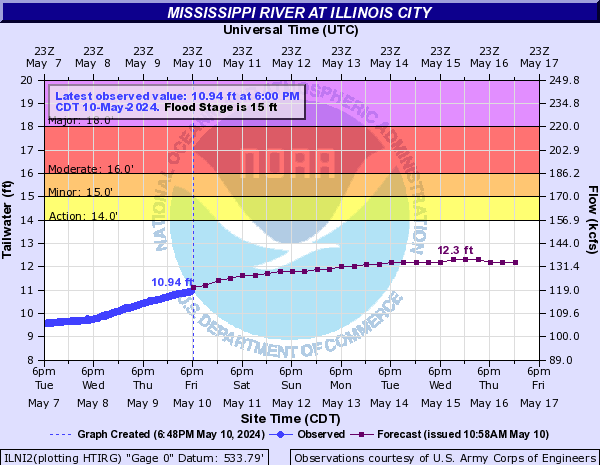
Mississippi River At Illinois City (ILNI2)
Return to TopNOTE: River forecasts for this location take into account past precipitation and the precipitation amounts expected approximately 24 hours into the future from the forecast issuance time.
Flood Stage: 15 Feet
Latest Stage: 7.51
Current Warnings/Statements/Advisories:None currently.
Flood Categories (in feet)
| Major Flood Stage: |
18 |
| Moderate Flood Stage: |
16 |
| Flood Stage: |
15 |
| Action Stage: |
14 |
| Low Stage (in feet): |
-9999 |
Historic Crests
(1) 24.10 ft on 07/09/1993
(2) 23.27 ft on 04/28/1965
(3) 23.23 ft on 05/03/2019
(4) 22.96 ft on 06/17/2008
(5) 22.81 ft on 06/02/2019
(6) 22.41 ft on 04/25/2001
(7) 22.23 ft on 07/05/2014
(8) 21.22 ft on 05/02/2023
(P)
(9) 20.83 ft on 04/10/2019
(10) 20.74 ft on 04/23/2011
Show More Historic Crests
(P): Preliminary values subject to further review.
Recent Crests
(1) 21.22 ft on 05/02/2023
(P)
(2) 22.81 ft on 06/02/2019
(3) 23.23 ft on 05/03/2019
(4) 20.83 ft on 04/10/2019
(5) 19.39 ft on 10/13/2018
(6) 17.22 ft on 05/12/2018
(7) 16.76 ft on 06/01/2017
(8) 15.87 ft on 09/30/2016
(9) 15.11 ft on 03/29/2016
(10) 13.52 ft on 06/18/2015
Show More Recent Crests
(P): Preliminary values subject to further review.
Low Water Records
Currently none available.
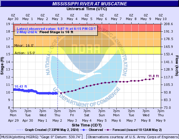
Mississippi River At Muscatine (MUSI4)
Return to TopNOTE: River forecasts for this location take into account past precipitation and the precipitation amounts expected approximately 24 hours into the future from the forecast issuance time.
Flood Stage: 16 Feet
Latest Stage: 9.27
Current Warnings/Statements/Advisories:None currently.
Flood Categories (in feet)
| Major Flood Stage: |
20 |
| Moderate Flood Stage: |
18 |
| Flood Stage: |
16 |
| Action Stage: |
15 |
| Low Stage (in feet): |
-9999 |
Historic Crests
(1) 25.61 ft on 07/09/1993
(2) 24.81 ft on 04/29/1965
(3) 24.52 ft on 06/02/2019
(4) 24.42 ft on 06/17/2008
(5) 24.33 ft on 05/03/2019
(P)
(6) 23.75 ft on 07/05/2014
(7) 23.50 ft on 04/25/2001
(8) 22.31 ft on 05/02/2023
(P)
(9) 21.95 ft on 04/10/2019
(P)
(10) 21.87 ft on 04/23/2011
Show More Historic Crests
(P): Preliminary values subject to further review.
Recent Crests
(1) 22.31 ft on 05/02/2023
(P)
(2) 24.52 ft on 06/02/2019
(3) 24.33 ft on 05/03/2019
(P)
(4) 21.95 ft on 04/10/2019
(P)
(5) 18.80 ft on 05/12/2018
(6) 18.20 ft on 06/01/2017
(7) 17.67 ft on 09/30/2016
(8) 15.31 ft on 06/18/2015
(9) 23.75 ft on 07/05/2014
(10) 21.86 ft on 04/22/2013
Show More Recent Crests
(P): Preliminary values subject to further review.
Low Water Records
Currently none available.
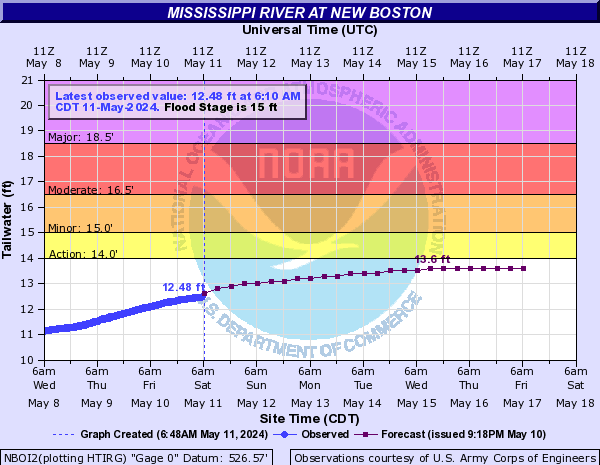
Mississippi River At New Boston (NBOI2)
Return to TopNOTE: River forecasts for this location take into account past precipitation and the precipitation amounts expected approximately 24 hours into the future from the forecast issuance time.
Flood Stage: 15 Feet
Latest Stage: 8.88
Current Warnings/Statements/Advisories:None currently.
Flood Categories (in feet)
| Major Flood Stage: |
18.5 |
| Moderate Flood Stage: |
16.5 |
| Flood Stage: |
15 |
| Action Stage: |
14 |
| Low Stage (in feet): |
-9999 |
Historic Crests
(1) 25.90 ft on 07/09/1993
(2) 25.20 ft on 06/17/2008
(3) 24.42 ft on 06/01/2019
(4) 23.59 ft on 05/03/2019
(5) 23.14 ft on 04/28/1965
(6) 22.46 ft on 04/25/2001
(7) 21.83 ft on 05/01/2008
(8) 21.73 ft on 04/25/1973
(9) 21.04 ft on 04/10/2019
(10) 20.96 ft on 04/24/2011
Show More Historic Crests
(P): Preliminary values subject to further review.
Recent Crests
(1) 20.85 ft on 05/03/2023
(P)
(2) 24.42 ft on 06/01/2019
(3) 23.59 ft on 05/03/2019
(4) 21.04 ft on 04/10/2019
(5) 18.47 ft on 05/12/2018
(6) 17.79 ft on 06/01/2017
(7) 18.70 ft on 09/30/2016
(8) 16.24 ft on 03/29/2016
(9) 15.54 ft on 06/19/2015
(10) 20.96 ft on 04/24/2011
Show More Recent Crests
(P): Preliminary values subject to further review.
Low Water Records
Currently none available.
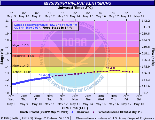
Mississippi River At Keithsburg (KHBI2)
Return to TopNOTE: River forecasts for this location take into account past precipitation and the precipitation amounts expected approximately 24 hours into the future from the forecast issuance time.
Flood Stage: 14 Feet
Latest Stage: 9.48
Current Warnings/Statements/Advisories:None currently.
Flood Categories (in feet)
| Major Flood Stage: |
17 |
| Moderate Flood Stage: |
15.5 |
| Flood Stage: |
14 |
| Action Stage: |
13 |
| Low Stage (in feet): |
-9999 |
Historic Crests
(1) 24.49 ft on 06/17/2008
(2) 24.15 ft on 07/09/1993
(3) 22.95 ft on 06/02/2019
(4) 22.62 ft on 07/05/2014
(5) 21.97 ft on 05/03/2019
(6) 20.72 ft on 05/12/2001
(7) 20.60 ft on 04/22/2013
(8) 20.46 ft on 04/28/1965
(9) 20.35 ft on 05/02/2008
(10) 19.35 ft on 04/25/1973
Show More Historic Crests
(P): Preliminary values subject to further review.
Recent Crests
(1) 19.12 ft on 05/03/2023
(P)
(2) 14.29 ft on 06/07/2020
(3) 22.95 ft on 06/02/2019
(4) 21.97 ft on 05/03/2019
(5) 19.17 ft on 04/10/2019
(6) 14.24 ft on 02/08/2019
(7) 17.27 ft on 09/09/2018
(8) 16.57 ft on 06/01/2017
(9) 17.30 ft on 09/30/2016
(10) 15.03 ft on 03/30/2016
Show More Recent Crests
(P): Preliminary values subject to further review.
Low Water Records
Currently none available.
Mississippi River At Gladstone (GLDI2)
Return to TopNOTE: River forecasts for this location take into account past precipitation and the precipitation amounts expected approximately 24 hours into the future from the forecast issuance time.
Flood Stage: 10 Feet
Latest Stage: 5.75
Current Warnings/Statements/Advisories:None currently.
Flood Categories (in feet)
| Major Flood Stage: |
14 |
| Moderate Flood Stage: |
12 |
| Flood Stage: |
10 |
| Action Stage: |
9 |
| Low Stage (in feet): |
-9999 |
Historic Crests
(1) 22.46 ft on 06/17/2008
(2) 21.54 ft on 07/10/1993
(3) 20.59 ft on 06/02/2019
(4) 19.77 ft on 07/05/2014
(5) 19.67 ft on 05/03/2019
(6) 18.00 ft on 04/22/2013
(7) 17.65 ft on 05/12/2001
(8) 17.40 ft on 04/25/1973
(9) 17.10 ft on 04/27/1965
(10) 17.04 ft on 05/02/2008
Show More Historic Crests
(P): Preliminary values subject to further review.
Recent Crests
(1) 15.93 ft on 05/04/2023
(P)
(2) 10.63 ft on 06/30/2020
(3) 11.06 ft on 06/07/2020
(4) 20.59 ft on 06/02/2019
(5) 19.67 ft on 05/03/2019
(6) 16.30 ft on 04/10/2019
(7) 14.23 ft on 09/10/2018
(8) 13.32 ft on 06/01/2017
(9) 13.74 ft on 09/30/2016
(10) 11.55 ft on 03/29/2016
Show More Recent Crests
(P): Preliminary values subject to further review.
Low Water Records
Currently none available.
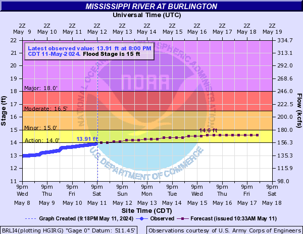
Mississippi River At Burlington (BRLI4)
Return to TopNOTE: River forecasts for this location take into account past precipitation and the precipitation amounts expected approximately 24 hours into the future from the forecast issuance time.
Flood Stage: 15 Feet
Latest Stage: 11.23
Current Warnings/Statements/Advisories:None currently.
Flood Categories (in feet)
| Major Flood Stage: |
18 |
| Moderate Flood Stage: |
16.5 |
| Flood Stage: |
15 |
| Action Stage: |
14 |
| Low Stage (in feet): |
-9999 |
Historic Crests
(1) 25.73 ft on 06/17/2008
(2) 25.10 ft on 07/10/1993
(3) 24.47 ft on 06/02/2019
(4) 23.65 ft on 07/06/2014
(5) 23.54 ft on 05/03/2019
(6) 21.82 ft on 05/14/2001
(7) 21.50 ft on 04/25/1973
(8) 21.18 ft on 05/02/2008
(9) 21.00 ft on 04/30/1965
(10) 20.51 ft on 03/25/2019
Show More Historic Crests
(P): Preliminary values subject to further review.
Recent Crests
(1) 20.00 ft on 05/04/2023
(P)
(2) 18.21 ft on 04/13/2020
(3) 18.36 ft on 10/15/2019
(4) 24.47 ft on 06/02/2019
(5) 23.54 ft on 05/03/2019
(6) 20.41 ft on 04/10/2019
(7) 20.51 ft on 03/25/2019
(8) 18.65 ft on 09/11/2018
(9) 17.73 ft on 07/03/2018
(10) 18.14 ft on 05/13/2018
Show More Recent Crests
(P): Preliminary values subject to further review.
Low Water Records
Currently none available.
Mississippi River At Keokuk (EOKI4)
Return to TopNOTE: River forecasts for this location take into account past precipitation and the precipitation amounts expected approximately 24 hours into the future from the forecast issuance time.
Flood Stage: 16 Feet
Latest Stage: 7.11
Current Warnings/Statements/Advisories:None currently.
Flood Categories (in feet)
| Major Flood Stage: |
19 |
| Moderate Flood Stage: |
17.5 |
| Flood Stage: |
16 |
| Action Stage: |
14 |
| Low Stage (in feet): |
-9999 |
Historic Crests
(1) 27.58 ft on 07/10/1993
(2) 26.95 ft on 06/17/2008
(3) 25.60 ft on 05/30/2019
(4) 23.50 ft on 04/23/1973
(5) 23.50 ft on 05/02/2019
(6) 23.38 ft on 07/07/2014
(7) 22.94 ft on 05/14/2001
(8) 22.20 ft on 04/20/2013
(9) 22.14 ft on 05/01/1965
(10) 21.83 ft on 04/04/1960
Show More Historic Crests
(P): Preliminary values subject to further review.
Recent Crests
(1) 17.71 ft on 05/05/2023
(P)
(2) 25.60 ft on 05/30/2019
(3) 23.50 ft on 05/02/2019
(4) 19.78 ft on 04/11/2019
(5) 16.91 ft on 09/11/2018
(6) 16.19 ft on 06/02/2017
(7) 16.84 ft on 12/28/2015
(8) 16.50 ft on 06/27/2015
(9) 23.38 ft on 07/07/2014
(10) 22.20 ft on 04/20/2013
Show More Recent Crests
(P): Preliminary values subject to further review.
Low Water Records
Currently none available.
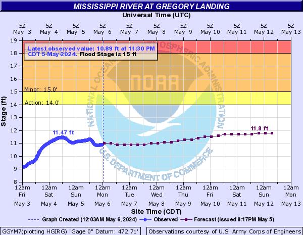
Mississippi River At Gregory Landing (GGYM7)
Return to TopNOTE: River forecasts for this location take into account past precipitation and the precipitation amounts expected approximately 24 hours into the future from the forecast issuance time.
Flood Stage: 15 Feet
Latest Stage: 8.47
Current Warnings/Statements/Advisories:None currently.
Flood Categories (in feet)
| Major Flood Stage: |
25 |
| Moderate Flood Stage: |
18 |
| Flood Stage: |
15 |
| Action Stage: |
14 |
| Low Stage (in feet): |
-9999 |
Historic Crests
(1) 28.49 ft on 07/09/1993
(2) 27.60 ft on 06/18/2008
(3) 26.97 ft on 06/02/2019
(4) 25.16 ft on 05/03/2019
(5) 24.60 ft on 04/24/1973
(6) 24.42 ft on 07/07/2014
(7) 24.04 ft on 05/15/2001
(8) 23.55 ft on 04/20/2013
(9) 22.70 ft on 05/01/1965
(10) 21.50 ft on 04/03/1960
Show More Historic Crests
(P): Preliminary values subject to further review.
Recent Crests
(1) 18.79 ft on 05/05/2023
(P)
(2) 15.40 ft on 06/11/2020
(3) 26.97 ft on 06/02/2019
(4) 25.16 ft on 05/03/2019
(5) 20.92 ft on 04/11/2019
(6) 15.60 ft on 03/11/2019
(7) 18.81 ft on 02/13/2019
(8) 18.02 ft on 09/10/2018
(9) 17.26 ft on 06/02/2017
(10) 17.71 ft on 10/06/2016
Show More Recent Crests
(P): Preliminary values subject to further review.
Low Water Records
Currently none available.
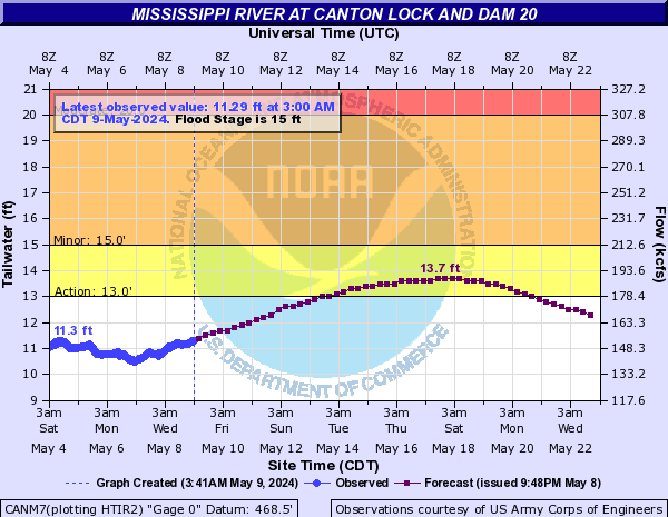
Mississippi River At Canton Lock and Dam 20 (CANM7)
Return to TopNOTE: River forecasts for this location take into account past precipitation and the precipitation amounts expected approximately 24 hours into the future from the forecast issuance time.
NOTE: For the latest navigation status update from the U.S. Army Corps of Engineers-St. Louis District,
click here. Flood Stage: 15 Feet
Latest Stage: 8.12
Current Warnings/Statements/Advisories:None currently.
Flood Categories (in feet)
| Major Flood Stage: |
25 |
| Moderate Flood Stage: |
20 |
| Flood Stage: |
15 |
| Action Stage: |
13 |
| Low Stage (in feet): |
-9999 |
Historic Crests
(1) 27.88 ft on 07/09/1993
(2) 27.73 ft on 06/18/2008
(3) 27.11 ft on 06/02/2019
(4) 24.50 ft on 04/24/1973
(5) 23.43 ft on 07/07/2014
(6) 23.20 ft on 05/15/2001
(7) 23.19 ft on 04/21/2013
(8) 21.42 ft on 05/01/1965
(9) 21.21 ft on 10/12/2018
(10) 20.92 ft on 10/04/1986
Show More Historic Crests
(P): Preliminary values subject to further review.
Recent Crests
(1) 18.28 ft on 05/05/2023
(2) 14.22 ft on 07/01/2022
(3) 14.06 ft on 06/08/2020
(4) 17.01 ft on 04/01/2020
(5) 17.57 ft on 10/17/2019
(6) 27.11 ft on 06/02/2019
(7) 21.21 ft on 10/12/2018
(8) 17.45 ft on 09/10/2018
(9) 16.68 ft on 07/03/2018
(10) 17.04 ft on 05/15/2018
Show More Recent Crests
(P): Preliminary values subject to further review.
Low Water Records (1) -4.00 ft on 12/26/1933
(2) -3.80 ft on 01/02/1934
(3) -3.60 ft on 12/14/1936
(4) -2.90 ft on 12/13/1937
(5) -2.80 ft on 01/17/1938
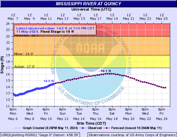
Show More Low Water Records Mississippi River At Quincy (UINI2)
Return to TopNOTE: River forecasts for this location take into account past precipitation and the precipitation amounts expected approximately 24 hours into the future from the forecast issuance time.
NOTE: For the latest navigation status update from the U.S. Army Corps of Engineers-St. Louis District,
click here. Flood Stage: 19 Feet
Latest Stage: 12.21
Current Warnings/Statements/Advisories:None currently.
Flood Categories (in feet)
| Major Flood Stage: |
26 |
| Moderate Flood Stage: |
22 |
| Flood Stage: |
19 |
| Action Stage: |
17 |
| Low Stage (in feet): |
-9999 |
Historic Crests
(1) 32.13 ft on 07/13/1993
(2) 31.16 ft on 05/03/2019
(3) 30.80 ft on 06/18/2008
(4) 28.90 ft on 04/25/1973
(5) 27.75 ft on 04/21/2013
(6) 27.31 ft on 05/16/2001
(7) 26.75 ft on 07/08/2014
(8) 25.30 ft on 10/04/1986
(9) 25.16 ft on 06/01/2013
(10) 24.81 ft on 10/12/2018
Show More Historic Crests
(P): Preliminary values subject to further review.
Recent Crests
(1) 21.18 ft on 05/05/2023
(2) 19.58 ft on 04/02/2020
(3) 20.05 ft on 10/17/2019
(4) 18.03 ft on 10/01/2019
(5) 17.33 ft on 07/09/2019
(6) 31.16 ft on 05/03/2019
(7) 24.81 ft on 10/12/2018
(8) 20.31 ft on 09/09/2018
(9) 19.15 ft on 07/05/2018
(10) 19.61 ft on 05/15/2018
Show More Recent Crests
(P): Preliminary values subject to further review.
Low Water Records (1) -3.40 ft on 12/14/1936
(2) -3.00 ft on 12/26/1933
(3) -2.20 ft on 01/17/1938
(4) -1.90 ft on 12/10/1910
(5) -1.60 ft on 12/23/1914
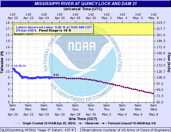
Show More Low Water Records Mississippi River At Quincy Lock and Dam 21 (QLDI2)
Return to TopNOTE: River forecasts for this location take into account past precipitation and the precipitation amounts expected approximately 24 hours into the future from the forecast issuance time.
NOTE: For the latest navigation status update from the U.S. Army Corps of Engineers-St. Louis District,
click here. Flood Stage: 18 Feet
Latest Stage: 8.57
Current Warnings/Statements/Advisories:None currently.
Flood Categories (in feet)
| Major Flood Stage: |
25 |
| Moderate Flood Stage: |
21 |
| Flood Stage: |
18 |
| Action Stage: |
16 |
| Low Stage (in feet): |
-9999 |
Historic Crests
(1) 31.30 ft on 07/13/1993
(2) 30.15 ft on 06/01/2019
(3) 29.58 ft on 06/18/2008
(4) 27.70 ft on 04/25/1973
(5) 27.24 ft on 04/21/2013
(6) 26.55 ft on 05/16/2001
(7) 26.15 ft on 07/08/2014
(8) 24.86 ft on 10/04/1986
(9) 24.74 ft on 06/01/2013
(10) 24.05 ft on 05/29/1996
Show More Historic Crests
(P): Preliminary values subject to further review.
Recent Crests
(1) 20.37 ft on 05/05/2023
(2) 18.86 ft on 04/02/2020
(3) 19.16 ft on 10/17/2019
(4) 17.29 ft on 10/02/2019
(5) 30.15 ft on 06/01/2019
(6) 23.96 ft on 10/12/2018
(7) 19.62 ft on 09/09/2018
(8) 18.47 ft on 07/05/2018
(9) 18.90 ft on 05/16/2018
(10) 18.52 ft on 06/03/2017
Show More Recent Crests
(P): Preliminary values subject to further review.
Low Water Records (1) -3.40 ft on 12/14/1936
(2) -3.00 ft on 12/26/1933
(3) -2.30 ft on 12/10/1910
(4) -2.20 ft on 01/17/1938
(5) -1.60 ft on 12/18/1922
Show More Low Water Records Mississippi River At Hannibal (HNNM7)
Return to TopNOTE: River forecasts for this location take into account past precipitation and the precipitation amounts expected approximately 24 hours into the future from the forecast issuance time.
NOTE: For the latest navigation status update from the U.S. Army Corps of Engineers-St. Louis District,
click here. Flood Stage: 17 Feet
Latest Stage: 12.57
Current Warnings/Statements/Advisories:None currently.
Flood Categories (in feet)
| Major Flood Stage: |
24 |
| Moderate Flood Stage: |
22 |
| Flood Stage: |
17 |
| Action Stage: |
15 |
| Low Stage (in feet): |
-9999 |
Historic Crests
(1) 31.80 ft on 07/15/1993
(2) 30.16 ft on 06/02/2019
(3) 29.54 ft on 06/18/2008
(4) 28.59 ft on 04/25/1973
(5) 27.63 ft on 04/21/2013
(6) 26.91 ft on 05/16/2001
(7) 26.68 ft on 07/08/2014
(8) 25.53 ft on 06/01/2013
(9) 25.30 ft on 10/04/1986
(10) 24.80 ft on 10/12/2018
Show More Historic Crests
(P): Preliminary values subject to further review.
Recent Crests
(1) 21.89 ft on 05/06/2023
(2) 17.40 ft on 04/28/2023
(3) 17.25 ft on 06/02/2022
(4) 17.03 ft on 05/07/2022
(5) 19.03 ft on 04/12/2021
(6) 18.35 ft on 03/19/2021
(7) 18.15 ft on 07/02/2020
(8) 18.79 ft on 06/11/2020
(9) 16.05 ft on 05/18/2020
(10) 20.34 ft on 04/02/2020
Show More Recent Crests
(P): Preliminary values subject to further review.
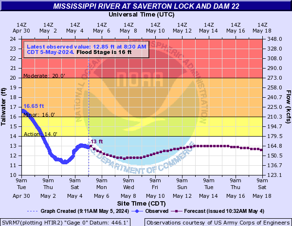
Mississippi River At Saverton Lock and Dam 22 (SVRM7)
Return to TopNOTE: River forecasts for this location take into account past precipitation and the precipitation amounts expected approximately 24 hours into the future from the forecast issuance time.
NOTE: For the latest navigation status update from the U.S. Army Corps of Engineers-St. Louis District,
click here. Flood Stage: 16 Feet
Latest Stage: 8.59
Current Warnings/Statements/Advisories:None currently.
Flood Categories (in feet)
| Major Flood Stage: |
24 |
| Moderate Flood Stage: |
20 |
| Flood Stage: |
16 |
| Action Stage: |
14 |
| Low Stage (in feet): |
-9999 |
Historic Crests
(1) 29.58 ft on 07/25/1993
(2) 28.48 ft on 06/02/2019
(3) 28.47 ft on 06/02/2019
(4) 28.00 ft on 06/18/2008
(5) 26.80 ft on 04/25/1973
(6) 26.42 ft on 04/21/2013
(7) 26.12 ft on 05/16/2001
(8) 25.78 ft on 07/08/2014
(9) 24.62 ft on 06/01/2013
(10) 24.10 ft on 10/05/1986
Show More Historic Crests
(P): Preliminary values subject to further review.
Recent Crests
(1) 20.38 ft on 05/06/2023
(2) 17.25 ft on 04/12/2021
(3) 16.36 ft on 03/19/2021
(4) 16.65 ft on 07/02/2020
(5) 17.30 ft on 06/12/2020
(6) 18.98 ft on 04/02/2020
(7) 19.32 ft on 10/17/2019
(8) 28.47 ft on 06/02/2019
(9) 28.48 ft on 06/02/2019
(10) 16.35 ft on 11/06/2018
Show More Recent Crests
(P): Preliminary values subject to further review.
Mississippi River At Louisiana (LUSM7)
Return to TopNOTE: River forecasts for this location take into account past precipitation and the precipitation amounts expected approximately 24 hours into the future from the forecast issuance time.
NOTE: For the latest navigation status update from the U.S. Army Corps of Engineers-St. Louis District,
click here. Flood Stage: 15 Feet
Latest Stage: 11.95
Current Warnings/Statements/Advisories:None currently.

Flood Categories (in feet)
| Major Flood Stage: |
25 |
| Moderate Flood Stage: |
20 |
| Flood Stage: |
15 |
| Action Stage: |
13 |
| Low Stage (in feet): |
-9999 |
Historic Crests
(1) 28.40 ft on 07/28/1993
(2) 27.72 ft on 06/02/2019
(3) 27.05 ft on 04/24/1973
(4) 26.96 ft on 06/23/2008
(5) 24.99 ft on 04/22/2013
(6) 24.43 ft on 05/16/2001
(7) 24.33 ft on 07/08/2014
(8) 22.79 ft on 10/13/2018
(9) 22.70 ft on 04/05/1983
(10) 22.70 ft on 10/05/1986
Show More Historic Crests
(P): Preliminary values subject to further review.
Recent Crests
(1) 19.98 ft on 05/06/2023
(2) 17.49 ft on 04/13/2021
(3) 16.98 ft on 03/19/2021
(4) 16.92 ft on 07/02/2020
(5) 17.31 ft on 06/11/2020
(6) 15.18 ft on 05/18/2020
(7) 18.91 ft on 04/03/2020
(8) 19.07 ft on 10/18/2019
(9) 27.72 ft on 06/02/2019
(10) 15.05 ft on 11/12/2018
Show More Recent Crests
(P): Preliminary values subject to further review.
Low Water Records (1) -3.20 ft on 12/07/1897
(2) -3.20 ft on 12/28/1933
(3) -0.20 ft on 10/21/1932
(4) 0.10 ft on 07/27/1911
(5) 0.80 ft on 10/20/1918
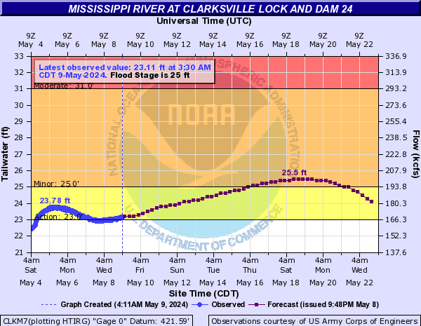
Show More Low Water Records Mississippi River At Clarksville Lock and Dam 24 (CLKM7)
Return to TopNOTE: River forecasts for this location take into account past precipitation and the precipitation amounts expected approximately 24 hours into the future from the forecast issuance time.
NOTE: For the latest navigation status update from the U.S. Army Corps of Engineers-St. Louis District,
click here. Flood Stage: 25 Feet
Latest Stage: 18.55
Current Warnings/Statements/Advisories:None currently.
Flood Categories (in feet)
| Major Flood Stage: |
33 |
| Moderate Flood Stage: |
31 |
| Flood Stage: |
25 |
| Action Stage: |
23 |
| Low Stage (in feet): |
-9999 |
Historic Crests
(1) 37.73 ft on 07/29/1993
(2) 37.11 ft on 06/02/2019
(3) 36.76 ft on 04/24/1973
(4) 36.70 ft on 06/24/2008
(5) 35.30 ft on 04/22/2013
(6) 34.78 ft on 07/09/2014
(7) 34.70 ft on 05/16/2001
(8) 33.70 ft on 10/05/1986
(9) 33.24 ft on 04/06/1983
(10) 33.13 ft on 10/13/2018
Show More Historic Crests
(P): Preliminary values subject to further review.
Recent Crests
(1) 30.26 ft on 05/06/2023
(2) 27.78 ft on 04/13/2021
(3) 27.22 ft on 03/19/2021
(4) 27.29 ft on 07/01/2020
(5) 27.57 ft on 06/12/2020
(6) 25.43 ft on 05/18/2020
(7) 29.12 ft on 04/03/2020
(8) 29.29 ft on 10/19/2019
(9) 37.11 ft on 06/02/2019
(10) 25.07 ft on 12/05/2018
Show More Recent Crests
(P): Preliminary values subject to further review.
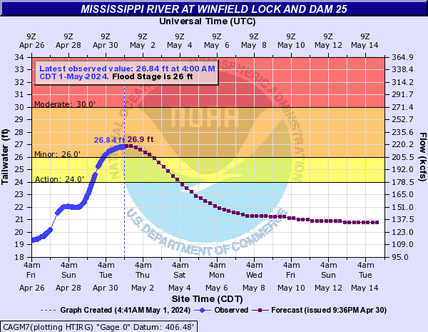
Mississippi River At Winfield Lock and Dam 25 (CAGM7)
Return to TopNOTE: River forecasts for this location take into account past precipitation and the precipitation amounts expected approximately 24 hours into the future from the forecast issuance time.
NOTE: For the latest navigation status update from the U.S. Army Corps of Engineers-St. Louis District,
click here. Flood Stage: 26 Feet
Latest Stage: 18.12
Current Warnings/Statements/Advisories:None currently.
Flood Categories (in feet)
| Major Flood Stage: |
34 |
| Moderate Flood Stage: |
30 |
| Flood Stage: |
26 |
| Action Stage: |
24 |
| Low Stage (in feet): |
-9999 |
Historic Crests
(1) 39.62 ft on 08/01/1993
(2) 38.59 ft on 06/04/2019
(3) 37.08 ft on 06/27/2008
(4) 36.93 ft on 04/27/1973
(5) 35.40 ft on 04/23/2013
(6) 34.70 ft on 07/10/2014
(7) 34.68 ft on 05/18/2001
(8) 34.39 ft on 12/30/2015
(9) 34.20 ft on 04/14/1979
(10) 33.98 ft on 04/07/1983
Show More Historic Crests
(P): Preliminary values subject to further review.
Recent Crests
(1) 30.24 ft on 05/07/2023
(2) 27.70 ft on 04/14/2021
(3) 27.83 ft on 03/20/2021
(4) 27.23 ft on 07/03/2020
(5) 27.79 ft on 06/13/2020
(6) 26.21 ft on 05/18/2020
(7) 29.49 ft on 04/01/2020
(8) 29.61 ft on 10/19/2019
(9) 38.59 ft on 06/04/2019
(10) 26.34 ft on 11/06/2018
Show More Recent Crests
(P): Preliminary values subject to further review.
Mississippi River At Grafton (GRFI2)
Return to TopNOTE: River forecasts for this location take into account past precipitation and the precipitation amounts expected approximately 24 hours into the future from the forecast issuance time.
NOTE: For the latest navigation status update from the U.S. Army Corps of Engineers-St. Louis District,
click here. Flood Stage: 20 Feet
Latest Stage: 15.41
Current Warnings/Statements/Advisories:None currently.
Flood Categories (in feet)
| Major Flood Stage: |
29 |
| Moderate Flood Stage: |
24 |
| Flood Stage: |
20 |
| Action Stage: |
18 |
| Low Stage (in feet): |
-9999 |
Historic Crests
(1) 38.17 ft on 08/01/1993
(2) 35.17 ft on 06/07/2019
(3) 33.12 ft on 04/28/1973
(4) 32.13 ft on 06/18/1844
(5) 32.10 ft on 05/07/2019
(6) 30.94 ft on 06/04/2013
(7) 30.91 ft on 12/31/2015
(8) 30.80 ft on 06/29/2008
(9) 30.70 ft on 06/15/1858
(10) 30.40 ft on 05/29/1995
Show More Historic Crests
(P): Preliminary values subject to further review.
Recent Crests
(1) 20.80 ft on 05/10/2023
(2) 21.28 ft on 05/07/2022
(3) 20.66 ft on 04/14/2021
(4) 21.86 ft on 03/20/2021
(5) 19.48 ft on 07/03/2020
(6) 22.54 ft on 06/01/2020
(7) 22.38 ft on 03/31/2020
(8) 20.12 ft on 01/13/2020
(9) 20.25 ft on 11/02/2019
(10) 22.67 ft on 10/13/2019
Show More Recent Crests
(P): Preliminary values subject to further review.
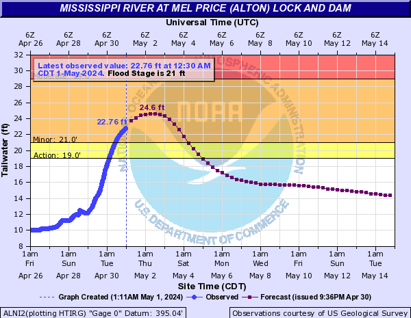
Mississippi River At Mel Price (Alton) Lock and Dam (ALNI2)
Return to TopNOTE: River forecasts for this location take into account past precipitation and the precipitation amounts expected approximately 24 hours into the future from the forecast issuance time.
NOTE: For the latest navigation status update from the U.S. Army Corps of Engineers-St. Louis District,
click here. Flood Stage: 21 Feet
Latest Stage: 9.11
Current Warnings/Statements/Advisories:None currently.
Flood Categories (in feet)
| Major Flood Stage: |
34 |
| Moderate Flood Stage: |
29 |
| Flood Stage: |
21 |
| Action Stage: |
19 |
| Low Stage (in feet): |
-9999 |
Historic Crests
(1) 42.72 ft on 08/01/1993
(2) 39.01 ft on 06/09/2019
(3) 36.90 ft on 06/18/1844
(4) 36.89 ft on 04/28/1973
(5) 35.80 ft on 01/01/2016
(6) 35.10 ft on 05/22/1995
(7) 34.86 ft on 05/06/2017
(8) 34.38 ft on 06/04/2013
(9) 34.20 ft on 10/09/1986
(10) 33.21 ft on 05/01/1983
Show More Historic Crests
(P): Preliminary values subject to further review.
Recent Crests
(1) 23.17 ft on 06/28/2021
(2) 22.90 ft on 04/14/2021
(3) 25.04 ft on 03/20/2021
(4) 25.14 ft on 06/01/2020
(5) 22.16 ft on 05/19/2020
(6) 22.32 ft on 04/30/2020
(7) 23.72 ft on 03/25/2020
(8) 23.33 ft on 01/13/2020
(9) 21.55 ft on 11/02/2019
(10) 21.17 ft on 11/01/2019
Show More Recent Crests
(P): Preliminary values subject to further review.
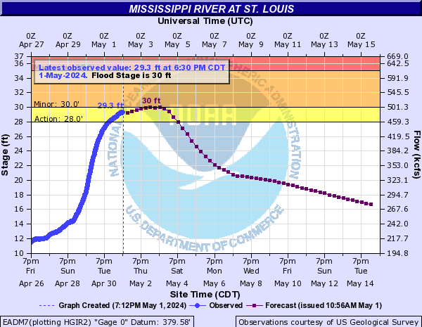
Mississippi River At St. Louis (EADM7)
Return to TopNOTE: River forecasts for this location take into account past precipitation and the precipitation amounts expected approximately 24 hours into the future from the forecast issuance time.
NOTE: For the latest navigation status update from the U.S. Army Corps of Engineers-St. Louis District,
click here. Flood Stage: 30 Feet
Latest Stage: 9.91
Current Warnings/Statements/Advisories:None currently.
Flood Categories (in feet)
| Major Flood Stage: |
40 |
| Moderate Flood Stage: |
35 |
| Flood Stage: |
30 |
| Action Stage: |
28 |
| Low Stage (in feet): |
-9999 |
Historic Crests
(1) 49.58 ft on 08/01/1993
(2) 46.02 ft on 06/09/2019
(3) 43.23 ft on 04/28/1973
(4) 42.52 ft on 01/01/2016
(5) 42.00 ft on 04/01/1785
(6) 41.89 ft on 05/22/1995
(7) 41.70 ft on 05/06/2017
(8) 41.32 ft on 06/27/1844
(9) 40.52 ft on 06/04/2013
(10) 40.30 ft on 07/02/1947
Show More Historic Crests
(P): Preliminary values subject to further review.
Recent Crests
(1) 31.46 ft on 03/21/2021
(P)
(2) 31.94 ft on 06/01/2020
(3) 30.34 ft on 03/25/2020
(4) 30.41 ft on 03/22/2020
(5) 30.59 ft on 01/13/2020
(6) 32.15 ft on 10/13/2019
(7) 46.02 ft on 06/09/2019
(8) 32.63 ft on 10/16/2018
(9) 31.76 ft on 05/25/2017
(10) 41.70 ft on 05/06/2017
Show More Recent Crests
(P): Preliminary values subject to further review.
Low Water Records (1) -6.20 ft on 01/16/1940
(2) -5.80 ft on 01/26/1963
(3) -5.60 ft on 01/01/1964
(4) -5.50 ft on 12/12/1937
(5) -5.32 ft on 12/26/1989
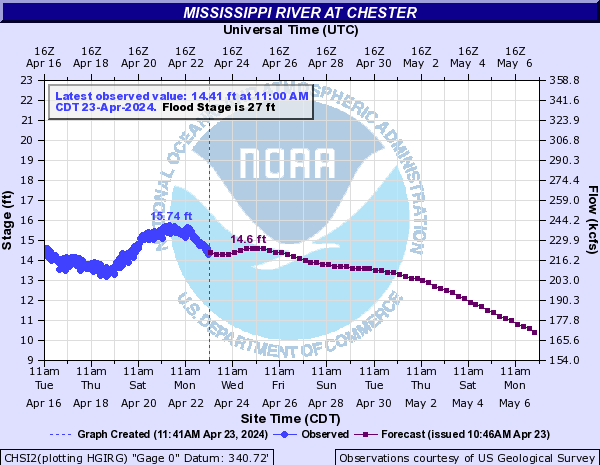
Show More Low Water Records Mississippi River At Chester (CHSI2)
Return to TopNOTE: River forecasts for this location take into account past precipitation and the precipitation amounts expected approximately 24 hours into the future from the forecast issuance time.
NOTE: For the latest navigation status update from the U.S. Army Corps of Engineers-St. Louis District,
click here. Flood Stage: 27 Feet
Latest Stage: 13.69
Current Warnings/Statements/Advisories:None currently.
Vertical Datum updated from NGVD29 to NAVD88 by gauge owner.
Flood Categories (in feet)
| Major Flood Stage: |
40 |
| Moderate Flood Stage: |
35 |
| Flood Stage: |
27 |
| Action Stage: |
25 |
| Low Stage (in feet): |
-9999 |
Historic Crests
(1) 49.74 ft on 08/07/1993
(2) 46.52 ft on 06/10/2019
(3) 45.99 ft on 01/02/2016
(4) 44.66 ft on 05/06/2017
(5) 44.00 ft on 05/23/1995
(6) 43.32 ft on 04/30/1973
(7) 42.41 ft on 06/05/2013
(8) 41.02 ft on 05/05/1983
(9) 40.58 ft on 05/17/2002
(10) 39.83 ft on 06/30/1844
Show More Historic Crests
(P): Preliminary values subject to further review.
Recent Crests
(1) 31.04 ft on 07/02/2021
(P)
(2) 30.76 ft on 04/14/2021
(P)
(3) 33.88 ft on 03/21/2021
(P)
(4) 33.46 ft on 06/02/2020
(5) 31.71 ft on 04/20/2020
(6) 33.32 ft on 03/25/2020
(7) 27.06 ft on 03/15/2020
(8) 33.07 ft on 01/14/2020
(9) 29.33 ft on 11/03/2019
(10) 33.04 ft on 10/13/2019
Show More Recent Crests
(P): Preliminary values subject to further review.
Low Water Records (1) -4.30 ft on 01/02/1964
(2) -4.20 ft on 12/20/1963
(3) -4.00 ft on 01/03/1900
(4) -3.71 ft on 12/27/1989
(5) -2.60 ft on 01/04/1940
Show More Low Water Records Mississippi River At Cape Girardeau (CPGM7)
Return to TopNOTE: River forecasts for this location take into account past precipitation and the precipitation amounts expected approximately 48 hours into the future from the forecast issuance time.
NOTE: For the latest navigation status update from the U.S. Army Corps of Engineers-St. Louis District,
click here. Flood Stage: 32 Feet
Latest Stage: 19.77
Current Warnings/Statements/Advisories:None currently.
Flood Categories (in feet)
| Major Flood Stage: |
42 |
| Moderate Flood Stage: |
37 |
| Flood Stage: |
32 |
| Action Stage: |
29 |
| Low Stage (in feet): |
5.4 |
Historic Crests
(1) 48.86 ft on 01/02/2016
(2) 48.49 ft on 08/08/1993
(3) 47.00 ft on 05/24/1995
(4) 46.90 ft on 08/03/1993
(5) 46.36 ft on 06/11/2019
Show More Historic Crests
(P): Preliminary values subject to further review.
Recent Crests
(1) 37.83 ft on 03/22/2021
(2) 37.49 ft on 01/15/2020
(3) 46.36 ft on 06/11/2019
(4) 36.82 ft on 10/18/2018
(5) 45.99 ft on 05/07/2017
Show More Recent Crests
(P): Preliminary values subject to further review.
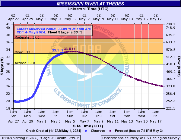
Mississippi River At Thebes (THBI2)
Return to TopNOTE: River forecasts for this location take into account past precipitation and the precipitation amounts expected approximately 48 hours into the future from the forecast issuance time.
NOTE: For the latest navigation status update from the U.S. Army Corps of Engineers-St. Louis District,
click here. Flood Stage: 33 Feet
Latest Stage: 19.97
Current Warnings/Statements/Advisories:None currently.
Flood Categories (in feet)
| Major Flood Stage: |
42 |
| Moderate Flood Stage: |
37 |
| Flood Stage: |
33 |
| Action Stage: |
30 |
| Low Stage (in feet): |
4 |
Historic Crests
(1) 47.74 ft on 01/02/2016
(2) 45.91 ft on 05/23/1995
(3) 45.52 ft on 05/03/2011
(4) 45.51 ft on 08/07/1993
(5) 45.15 ft on 07/04/1844
Show More Historic Crests
(P): Preliminary values subject to further review.
Recent Crests
(1) 36.47 ft on 03/22/2021
(2) 36.32 ft on 03/27/2020
(3) 43.66 ft on 06/11/2019
(4) 35.84 ft on 10/18/2018
(5) 43.18 ft on 05/06/2017
Show More Recent Crests
(P): Preliminary values subject to further review.
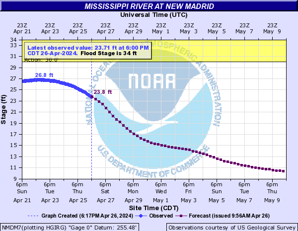
Mississippi River At New Madrid (NMDM7)
Return to TopNOTE: River forecasts for this location take into account past precipitation and the precipitation amounts expected approximately 48 hours into the future from the forecast issuance time.
Flood Stage: 34 Feet
Latest Stage: 26.13
Current Warnings/Statements/Advisories:None currently.
Flood Categories (in feet)
| Major Flood Stage: |
44 |
| Moderate Flood Stage: |
40 |
| Flood Stage: |
34 |
| Action Stage: |
30 |
| Low Stage (in feet): |
-1.2 |
Historic Crests
(1) 48.35 ft on 05/06/2011
(2) 48.00 ft on 02/03/1937
(3) 45.27 ft on 04/29/2011
(4) 44.60 ft on 04/09/1913
(5) 43.60 ft on 04/04/1975
Show More Historic Crests
(P): Preliminary values subject to further review.
Recent Crests
(1) 35.20 ft on 03/09/2022
(2) 35.09 ft on 04/04/2021
(3) 40.17 ft on 04/01/2020
(4) 42.99 ft on 03/02/2019
(5) 41.41 ft on 03/05/2018
Show More Recent Crests
(P): Preliminary values subject to further review.