Flood ImpactsIf you notice any errors in the below information, please contact our Webmaster
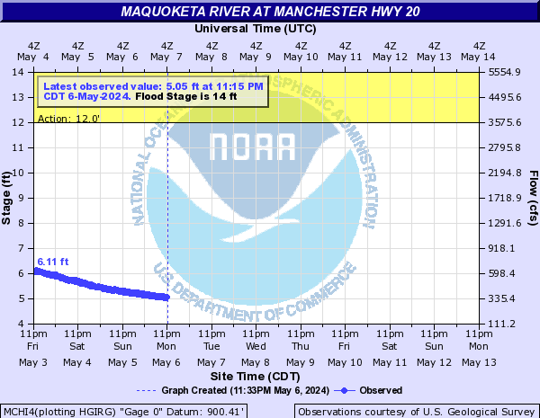
28
Water reaches the bottom of the U.S. Highway 20 bridges.
19
Water affects businesses along W Main Street.
17
West Main Street and State Highway 13 is closed in Manchester.
16.5
Water is on River Street and Main Street in Manchester.
15.7
Water is on Schram Drive leading to Schram Park in Manchester.
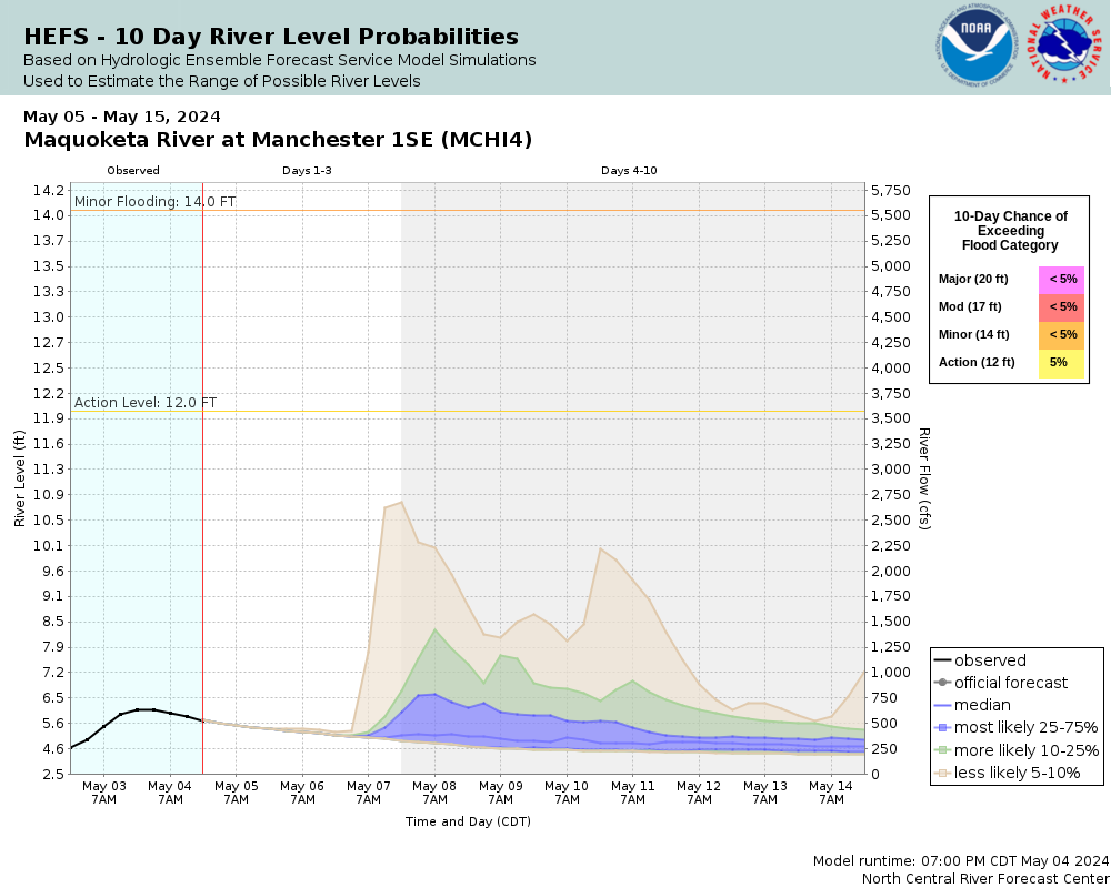
14
Water affects West Main Street. Water also affects residences on the south side of town.
12.5
Water affects the campgrounds at lower Bailey's Ford Park.
Flood Categories (in feet)
| Major Flood Stage: |
20 |
| Moderate Flood Stage: |
17 |
| Flood Stage: |
14 |
| Action Stage: |
12 |
| Low Stage (in feet): |
-9999 |
Historic Crests
(1) 24.48 ft on 07/24/2010
(2) 21.66 ft on 05/23/2004
(3) 20.80 ft on 05/26/2008
(4) 20.50 ft on 06/09/2008
(5) 20.34 ft on 09/23/2016
(6) 20.10 ft on 05/30/2008
(7) 19.31 ft on 05/30/2013
(8) 18.95 ft on 04/25/2008
(9) 18.35 ft on 06/04/2002
(10) 17.71 ft on 03/15/2019
(P)
Show More Historic Crests
(P): Preliminary values subject to further review.
Recent Crests
(1) 17.71 ft on 03/15/2019
(P)
(2) 20.34 ft on 09/23/2016
(3) 16.14 ft on 06/20/2014
(P)
(4) 19.31 ft on 05/30/2013
(5) 24.48 ft on 07/24/2010
(6) 14.37 ft on 04/27/2009
(7) 20.50 ft on 06/09/2008
(8) 20.10 ft on 05/30/2008
(9) 20.80 ft on 05/26/2008
(10) 18.95 ft on 04/25/2008
Show More Recent Crests
(P): Preliminary values subject to further review.
Low Water Records
Currently none available.