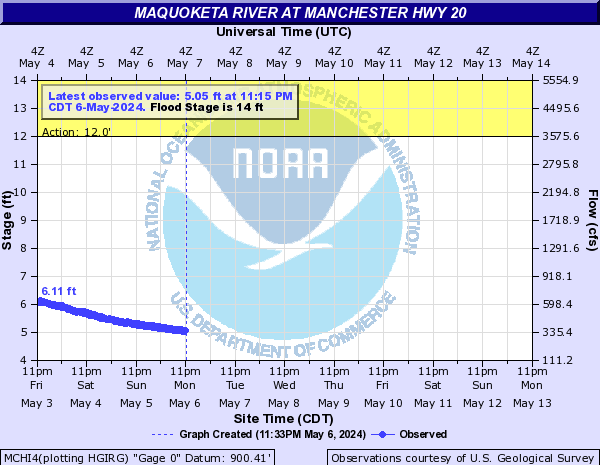
Flood ImpactsIf you notice any errors in the below information, please contact our Webmaster
39
Water reaches the bottom of the Iowa Highway 62 bridge deck at Maquoketa.
37
Water is at the floor level of the Maquoketa Municipal Light Plant.
35
Water reaches the top of the levee which protects the industrial section at the north end of Maquoketa. Water reaches the bottom of the bridge deck at Main Street in Maquoketa.
30
Water affects the Maquoketa Municipal Light Plant facilities and affects Highway 113.
28.5
Major Flood Stage. Water is affecting the north side of the city of Maquoketa and widespread agricultural flooding.
27
Water affects industries on the north end of Maquoketa.
26
Moderate Flood Stage. Significant agricultural flooding and increasing impacts on the city of Maquoketa.
24
Minor Flood Stage. Water affects agricultural land in the Maquoketa area and causes backups of storm sewers in town.
Flood Categories (in feet)
| Major Flood Stage: |
28.5 |
| Moderate Flood Stage: |
26 |
| Flood Stage: |
24 |
| Action Stage: |
23 |
| Low Stage (in feet): |
-9999 |
Historic Crests
(1) 35.26 ft on 07/26/2010
(2) 34.09 ft on 06/05/2002
(3) 32.86 ft on 07/06/1993
(4) 32.41 ft on 03/15/2019
(5) 31.23 ft on 06/14/2008
(6) 30.96 ft on 07/01/2014
(7) 30.63 ft on 03/22/1975
(8) 29.73 ft on 02/21/1997
(9) 29.65 ft on 03/11/2013
(10) 29.60 ft on 08/31/1981
Show More Historic Crests
(P): Preliminary values subject to further review.
Recent Crests
(1) 26.04 ft on 10/04/2019
(2) 32.41 ft on 03/15/2019
(3) 24.86 ft on 02/05/2019
(4) 28.29 ft on 02/20/2018
(5) 22.31 ft on 07/22/2017
(6) 24.37 ft on 09/25/2016
(7) 19.92 ft on 06/12/2015
(8) 30.96 ft on 07/01/2014
(9) 29.65 ft on 03/11/2013
(10) 14.11 ft on 03/01/2012
Show More Recent Crests
(P): Preliminary values subject to further review.
Low Water Records
Currently none available.