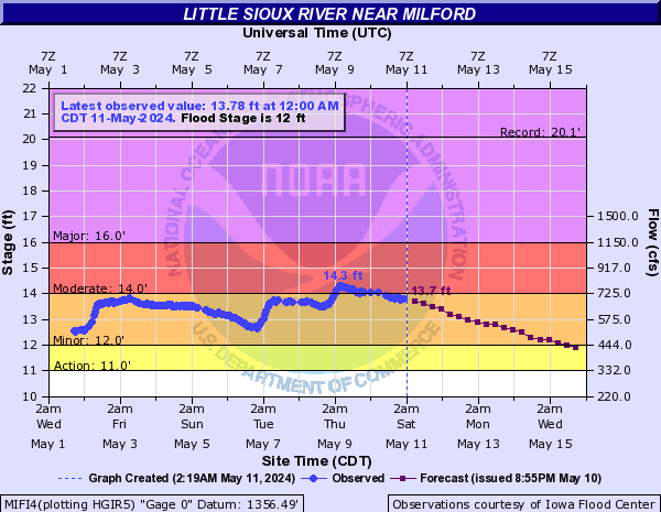
Little Sioux River Near Milford (MIFI4)
Return to TopNOTE: River forecasts for this location take into account past precipitation and the precipitation amounts expected approximately 48 hours into the future from the forecast issuance time.
Flood Stage: 12 Feet
Latest Stage: 9.83
Flood Categories (in feet)
| Major Flood Stage: |
16 |
| Moderate Flood Stage: |
14 |
| Flood Stage: |
12 |
| Action Stage: |
11 |
| Low Stage (in feet): |
-9999 |
Historic Crests
(1) 20.10 ft on 06/25/2018
(2) 18.02 ft on 03/18/2019
(3) 17.50 ft on 07/15/2011
(4) 17.37 ft on 06/19/2014
(5) 16.84 ft on 08/23/2007
Show More Historic Crests
(P): Preliminary values subject to further review.
Recent Crests
(1) 13.59 ft on 04/05/2023
(2) 15.19 ft on 03/09/2020
(3) 18.02 ft on 03/18/2019
(4) 20.10 ft on 06/25/2018
(5) 12.50 ft on 05/24/2017
Show More Recent Crests
(P): Preliminary values subject to further review.
Low Water Records
Currently none available.
Little Sioux River Above Spencer (LSSI4)
Return to TopNOTE: River forecasts for this location take into account past precipitation and the precipitation amounts expected approximately 48 hours into the future from the forecast issuance time.
Flood Stage: 0 KCFS
Latest Flow: n/a
Current Warnings/Statements/Advisories:None currently.
Flood Categories (in feet)
| Major Flood Stage: |
15 |
| Moderate Flood Stage: |
13 |
| Flood Stage: |
10 |
| Action Stage: |
9 |
| Low Stage (in feet): |
-9999 |
Historic Crests
(1) 14.45 ft on 07/15/2011
(2) 13.49 ft on 06/20/2014
(3) 13.20 ft on 03/18/2010
(4) 10.99 ft on 03/10/2013
(5) 9.95 ft on 06/01/2012
(P): Preliminary values subject to further review.
Recent Crests
(1) 13.49 ft on 06/20/2014
(2) 10.99 ft on 03/10/2013
(3) 9.95 ft on 06/01/2012
(4) 14.45 ft on 07/15/2011
(5) 13.20 ft on 03/18/2010
(P): Preliminary values subject to further review.
Low Water Records
Currently none available.
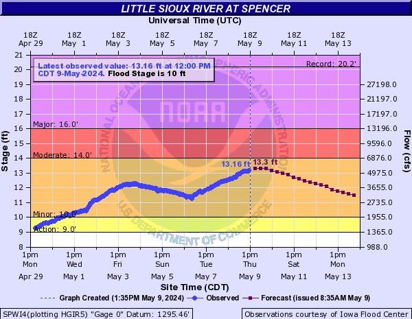
Little Sioux River At Spencer (SPWI4)
Return to TopNOTE: River forecasts for this location take into account past precipitation and the precipitation amounts expected approximately 48 hours into the future from the forecast issuance time.
Flood Stage: 10 Feet
Latest Stage: 8.08
Flood Categories (in feet)
| Major Flood Stage: |
16 |
| Moderate Flood Stage: |
14 |
| Flood Stage: |
10 |
| Action Stage: |
9 |
| Low Stage (in feet): |
-9999 |
Historic Crests
(1) 20.20 ft on 06/08/1953
(2) 17.60 ft on 06/21/1954
(3) 17.45 ft on 03/15/2019
(4) 17.40 ft on 06/26/2018
(5) 17.37 ft on 04/06/1965
Show More Historic Crests
(P): Preliminary values subject to further review.
Recent Crests
(1) 10.89 ft on 05/16/2023
(2) 11.70 ft on 03/10/2020
(3) 17.45 ft on 03/15/2019
(4) 17.40 ft on 06/26/2018
(5) 12.20 ft on 05/23/2017
Show More Recent Crests
(P): Preliminary values subject to further review.
Low Water Records
Currently none available.
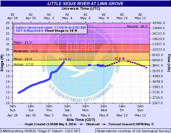
Little Sioux River At Linn Grove (LNNI4)
Return to TopNOTE: River forecasts for this location take into account past precipitation and the precipitation amounts expected approximately 48 hours into the future from the forecast issuance time.
Flood Stage: 18 Feet
Latest Stage: 11.06
Flood Categories (in feet)
| Major Flood Stage: |
21 |
| Moderate Flood Stage: |
19.5 |
| Flood Stage: |
18 |
| Action Stage: |
17 |
| Low Stage (in feet): |
-9999 |
Historic Crests
(1) 24.13 ft on 03/16/2019
(2) 23.91 ft on 09/22/2018
(3) 22.91 ft on 06/18/2014
(4) 22.85 ft on 03/17/2010
(5) 22.57 ft on 07/17/2011
Show More Historic Crests
(P): Preliminary values subject to further review.
Recent Crests
(1) 13.90 ft on 05/18/2023
(2) 7.76 ft on 03/09/2021
(3) 15.72 ft on 05/29/2020
(4) 24.13 ft on 03/16/2019
(5) 23.91 ft on 09/22/2018
Show More Recent Crests
(P): Preliminary values subject to further review.
Low Water Records
Currently none available.
Little Sioux River At Cherokee (CHKI4)
Return to TopNOTE: River forecasts for this location take into account past precipitation and the precipitation amounts expected approximately 48 hours into the future from the forecast issuance time.
Flood Stage: 17 Feet
Latest Stage: 11.16
Flood Categories (in feet)
| Major Flood Stage: |
24 |
| Moderate Flood Stage: |
21 |
| Flood Stage: |
17 |
| Action Stage: |
15 |
| Low Stage (in feet): |
-9999 |
Historic Crests
(1) 28.40 ft on 03/14/2019
(2) 27.90 ft on 05/27/2013
(3) 27.30 ft on 06/27/2010
(4) 27.20 ft on 04/07/1965
(5) 27.08 ft on 07/18/1993
Show More Historic Crests
(P): Preliminary values subject to further review.
Recent Crests
(1) 12.71 ft on 05/18/2023
(2) 16.38 ft on 05/28/2020
(3) 28.40 ft on 03/14/2019
(4) 27.00 ft on 09/21/2018
(5) 19.83 ft on 05/04/2016
Show More Recent Crests
(P): Preliminary values subject to further review.
Low Water Records
Currently none available.
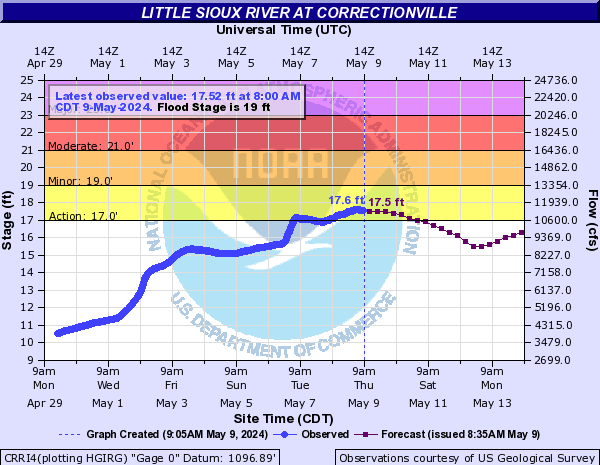
Little Sioux River At Correctionville (CRRI4)
Return to TopNOTE: River forecasts for this location take into account past precipitation and the precipitation amounts expected approximately 48 hours into the future from the forecast issuance time.
Flood Stage: 19 Feet
Latest Stage: 8.04
Flood Categories (in feet)
| Major Flood Stage: |
23 |
| Moderate Flood Stage: |
21 |
| Flood Stage: |
19 |
| Action Stage: |
17 |
| Low Stage (in feet): |
-9999 |
Historic Crests
(1) 29.34 ft on 06/23/1891
(2) 26.45 ft on 03/15/2019
(3) 25.86 ft on 04/07/1965
(4) 25.35 ft on 05/28/2013
(5) 24.39 ft on 06/20/2014
Show More Historic Crests
(P): Preliminary values subject to further review.
Recent Crests
(1) 12.91 ft on 02/28/2023
(2) 13.64 ft on 05/28/2020
(3) 26.45 ft on 03/15/2019
(4) 24.30 ft on 09/24/2018
(5) 13.66 ft on 05/27/2017
Show More Recent Crests
(P): Preliminary values subject to further review.
Low Water Records
Currently none available.
West Fork Ditch Near Hornick (HOKI4)
Return to TopNOTE: River forecasts for this location take into account past precipitation and the precipitation amounts expected approximately 48 hours into the future from the forecast issuance time.
Flood Stage: 20 Feet
Latest Stage: 7.55
Flood Categories (in feet)
| Major Flood Stage: |
26.5 |
| Moderate Flood Stage: |
22 |
| Flood Stage: |
20 |
| Action Stage: |
18 |
| Low Stage (in feet): |
-9999 |
Historic Crests
(1) 26.52 ft on 03/14/2019
(2) 25.87 ft on 06/22/1996
(3) 25.20 ft on 03/30/1960
(4) 23.70 ft on 08/18/2015
(5) 23.59 ft on 06/17/2014
Show More Historic Crests
(P): Preliminary values subject to further review.
Recent Crests
(1) 18.74 ft on 02/27/2023
(2) 7.82 ft on 03/25/2021
(3) 13.77 ft on 12/29/2019
(4) 26.52 ft on 03/14/2019
(5) 0.00 ft on 02/12/2017
Show More Recent Crests
(P): Preliminary values subject to further review.
Low Water Records
Currently none available.
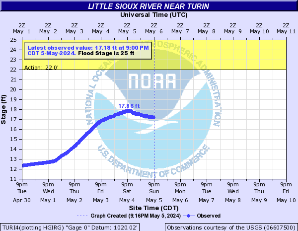
Little Sioux River Near Turin (TURI4)
Return to TopNOTE: River forecasts for this location take into account past precipitation and the precipitation amounts expected approximately 24 hours into the future from the forecast issuance time.
Flood Stage: 25 Feet
Latest Stage: 9.37
Flood Categories (in feet)
| Major Flood Stage: |
34.5 |
| Moderate Flood Stage: |
28 |
| Flood Stage: |
25 |
| Action Stage: |
22 |
| Low Stage (in feet): |
-9999 |
Historic Crests
(1) 29.57 ft on 03/15/2019
(2) 27.44 ft on 02/19/1971
(3) 26.99 ft on 06/22/1996
(4) 26.54 ft on 06/21/1983
(5) 26.47 ft on 03/19/1978
Show More Historic Crests
(P): Preliminary values subject to further review.
Recent Crests
(1) 10.25 ft on 06/05/2022
(2) 9.07 ft on 03/04/2021
(3) 16.02 ft on 02/24/2020
(4) 29.57 ft on 03/15/2019
(5) 23.86 ft on 09/25/2018
Show More Recent Crests
(P): Preliminary values subject to further review.
Low Water Records
Currently none available.
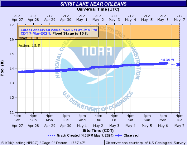
Spirit Lake Near Orleans (SLKI4)
Return to TopNOTE: No forecasts are available for this location
Flood Stage: 16 Feet
Latest Stage: 13.56
Flood Categories (in feet)
| Major Flood Stage: |
19 |
| Moderate Flood Stage: |
17 |
| Flood Stage: |
16 |
| Action Stage: |
15.5 |
| Low Stage (in feet): |
-9999 |
Historic Crests
(1) 18.79 ft on 07/18/1993
(2) 15.94 ft on 07/05/2018
(3) 15.76 ft on 04/12/1995
(4) 15.72 ft on 07/10/1969
(5) 15.68 ft on 03/31/2007
Show More Historic Crests
(P): Preliminary values subject to further review.
Recent Crests
(1) 14.70 ft on 05/14/2023
(2) 15.03 ft on 04/01/2020
(3) 15.58 ft on 03/26/2019
(4) 15.94 ft on 07/05/2018
(5) 15.05 ft on 05/24/2017
Show More Recent Crests
(P): Preliminary values subject to further review.
Low Water Records
Currently none available.
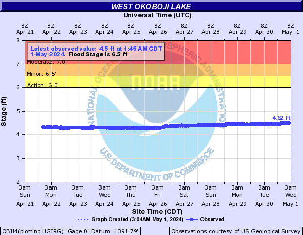
Milford Creek Near Milford (OBJI4)
Return to TopNOTE: No forecasts are available for this location
Flood Stage: 6.5 Feet
Latest Stage: 4.32
Flood Categories (in feet)
| Major Flood Stage: |
9 |
| Moderate Flood Stage: |
7 |
| Flood Stage: |
6.5 |
| Action Stage: |
6 |
| Low Stage (in feet): |
-9999 |
Historic Crests
(1) 8.66 ft on 07/17/1993
(2) 6.60 ft on 07/05/2018
(3) 6.25 ft on 07/16/2011
(4) 6.23 ft on 06/24/1984
(5) 6.14 ft on 07/08/1962
Show More Historic Crests
(P): Preliminary values subject to further review.
Recent Crests
(1) 4.69 ft on 05/15/2023
(2) 5.24 ft on 06/05/2020
(3) 5.98 ft on 05/31/2019
(4) 6.60 ft on 07/05/2018
(5) 5.15 ft on 05/27/2017
Show More Recent Crests
(P): Preliminary values subject to further review.
Low Water Records
Currently none available.
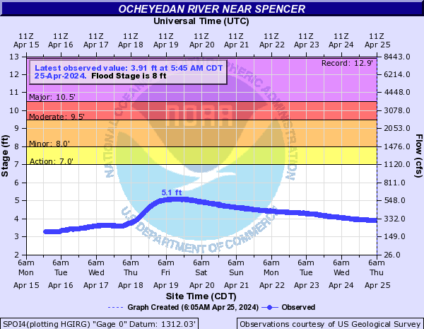
Ocheyedan River Near Spencer (SPOI4)
Return to TopNOTE: River forecasts for this location take into account past precipitation and the precipitation amounts expected approximately 48 hours into the future from the forecast issuance time.
Flood Stage: 8 Feet
Latest Stage: 5.06
Flood Categories (in feet)
| Major Flood Stage: |
10.5 |
| Moderate Flood Stage: |
9.5 |
| Flood Stage: |
8 |
| Action Stage: |
7 |
| Low Stage (in feet): |
-9999 |
Historic Crests
(1) 12.89 ft on 06/18/1953
(2) 12.77 ft on 09/21/2018
(3) 12.73 ft on 03/15/2019
(4) 12.70 ft on 06/21/2018
(5) 11.72 ft on 08/11/2010
Show More Historic Crests
(P): Preliminary values subject to further review.
Recent Crests
(1) 6.70 ft on 04/03/2023
(2) 6.46 ft on 05/31/2022
(3) 3.05 ft on 04/09/2021
(4) 8.57 ft on 05/27/2020
(5) 12.73 ft on 03/15/2019
Show More Recent Crests
(P): Preliminary values subject to further review.
Low Water Records
Currently none available.