Little Vermillion River Near Salem (LVSS2)
Return to TopNOTE: No forecasts are available for this location
Flood Stage: 0 KCFS
Latest Flow: n/a
Current Warnings/Statements/Advisories:None currently.
Flood Categories (in feet)
| Major Flood Stage: |
9 |
| Moderate Flood Stage: |
8 |
| Flood Stage: |
7 |
| Action Stage: |
6 |
| Low Stage (in feet): |
-9999 |
Historic Crests
(1) 11.95 ft on 07/04/1993
(2) 10.01 ft on 03/28/1997
(3) 9.88 ft on 06/20/1984
(4) 9.28 ft on 03/14/2010
(5) 9.21 ft on 03/17/2011
Show More Historic Crests
(P): Preliminary values subject to further review.
Recent Crests
(1) 9.21 ft on 03/17/2011
(2) 9.28 ft on 03/14/2010
(3) 6.57 ft on 07/13/2009
(4) 9.17 ft on 06/07/2008
(5) 8.42 ft on 03/12/2007
Show More Recent Crests
(P): Preliminary values subject to further review.
Low Water Records
Currently none available.
()
Return to TopFlood Flow: Not available
Latest Flow: n/a
Current Warnings/Statements/Advisories:None currently.
Flood Categories (in feet)
| Major Flood Stage: |
|
| Moderate Flood Stage: |
|
| Flood Stage: |
|
| Action Stage: |
|
| Low Stage (in feet): |
0 |
Historic Crests
Currently none available.
Recent Crests
Currently none available.
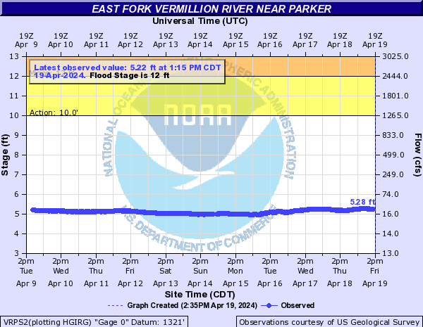
East Fork Vermillion River Near Parker (VRPS2)
Return to TopNOTE: River forecasts for this location take into account past precipitation and the precipitation amounts expected approximately 48 hours into the future from the forecast issuance time.
Flood Stage: 12 Feet
Latest Stage: 5.1
Current Warnings/Statements/Advisories:None currently.
Flood Categories (in feet)
| Major Flood Stage: |
16.5 |
| Moderate Flood Stage: |
14 |
| Flood Stage: |
12 |
| Action Stage: |
10 |
| Low Stage (in feet): |
-9999 |
Historic Crests
(1) 17.60 ft on 09/13/2019
(2) 16.09 ft on 03/14/2019
(3) 14.92 ft on 03/13/2010
(4) 12.73 ft on 03/22/1997
(5) 12.18 ft on 06/25/2003
Show More Historic Crests
(P): Preliminary values subject to further review.
Recent Crests
(1) 9.39 ft on 04/10/2023
(2) 5.14 ft on 07/08/2022
(3) 5.04 ft on 04/12/2021
(4) 9.62 ft on 03/09/2020
(5) 17.60 ft on 09/13/2019
Show More Recent Crests
(P): Preliminary values subject to further review.
Low Water Records
Currently none available.
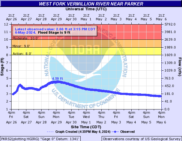
West Fork Vermillion River Near Parker (PKRS2)
Return to TopNOTE: River forecasts for this location take into account past precipitation and the precipitation amounts expected approximately 48 hours into the future from the forecast issuance time.
Flood Stage: 9 Feet
Latest Stage: 1.72
Current Warnings/Statements/Advisories:None currently.
Flood Categories (in feet)
| Major Flood Stage: |
12 |
| Moderate Flood Stage: |
10 |
| Flood Stage: |
9 |
| Action Stage: |
8 |
| Low Stage (in feet): |
-9999 |
Historic Crests
(1) 13.14 ft on 05/08/1993
(2) 13.08 ft on 09/13/2019
(3) 12.57 ft on 06/16/1984
(4) 12.35 ft on 04/19/1995
(5) 12.33 ft on 03/28/1962
Show More Historic Crests
(P): Preliminary values subject to further review.
Recent Crests
(1) 6.05 ft on 04/02/2023
(2) 2.32 ft on 05/13/2022
(3) 1.35 ft on 03/25/2021
(4) 6.54 ft on 03/05/2020
(5) 13.08 ft on 09/13/2019
Show More Recent Crests
(P): Preliminary values subject to further review.
Low Water Records
Currently none available.
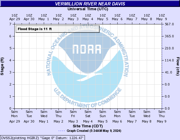
Vermillion River Near Davis (DVSS2)
Return to TopNOTE: River forecasts for this location take into account past precipitation and the precipitation amounts expected approximately 48 hours into the future from the forecast issuance time.
NOTE: Gauge readings not routinely updated during non-flooding situations.
Flood Stage: 0 KCFS
Latest Flow: n/a
Current Warnings/Statements/Advisories:None currently.
Flood Categories (in feet)
| Major Flood Stage: |
15 |
| Moderate Flood Stage: |
13 |
| Flood Stage: |
11 |
| Action Stage: |
10 |
| Low Stage (in feet): |
-9999 |
Historic Crests
(1) 16.40 ft on 03/15/2010
(2) 16.20 ft on 03/15/2019
(3) 15.75 ft on 04/07/1969
(4) 15.60 ft on 07/05/1993
(5) 15.10 ft on 06/22/1984
Show More Historic Crests
(P): Preliminary values subject to further review.
Recent Crests
(1) 9.59 ft on 04/03/2023
(2) 12.20 ft on 03/07/2020
(3) 16.20 ft on 03/15/2019
(4) 14.40 ft on 06/23/2018
(5) 12.60 ft on 06/18/2014
Show More Recent Crests
(P): Preliminary values subject to further review.
Low Water Records
Currently none available.
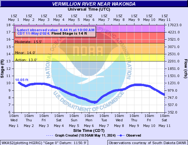
Vermillion River Near Wakonda (WKAS2)
Return to TopNOTE: River forecasts for this location take into account past precipitation and the precipitation amounts expected approximately 48 hours into the future from the forecast issuance time.
Flood Stage: 14 Feet
Latest Stage: 3.7
Current Warnings/Statements/Advisories:None currently.
Flood Categories (in feet)
| Major Flood Stage: |
17 |
| Moderate Flood Stage: |
15.5 |
| Flood Stage: |
14 |
| Action Stage: |
13 |
| Low Stage (in feet): |
-9999 |
Historic Crests
(1) 18.11 ft on 03/15/2019
(2) 17.62 ft on 06/23/1984
(3) 17.60 ft on 03/17/2010
(4) 17.50 ft on 06/25/2018
(5) 17.38 ft on 03/20/2011
Show More Historic Crests
(P): Preliminary values subject to further review.
Recent Crests
(1) 10.46 ft on 04/05/2023
(2) 15.10 ft on 03/09/2020
(3) 18.11 ft on 03/15/2019
(4) 17.50 ft on 06/25/2018
(5) 12.64 ft on 05/01/2017
Show More Recent Crests
(P): Preliminary values subject to further review.
Low Water Records
Currently none available.
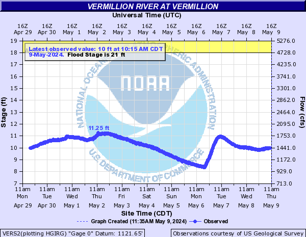
Vermillion River At Vermillion (VERS2)
Return to TopNOTE: River forecasts for this location take into account past precipitation and the precipitation amounts expected approximately 48 hours into the future from the forecast issuance time.
Flood Stage: 21 Feet
Latest Stage: 4.4
Current Warnings/Statements/Advisories:None currently.
Vertical datum height surveyed by the USGS
Flood Categories (in feet)
| Major Flood Stage: |
30 |
| Moderate Flood Stage: |
22 |
| Flood Stage: |
21 |
| Action Stage: |
18 |
| Low Stage (in feet): |
-9999 |
Historic Crests
(1) 31.77 ft on 06/23/1984
(2) 29.87 ft on 03/16/2019
(3) 26.68 ft on 07/08/1993
(4) 26.09 ft on 03/19/2010
(5) 23.80 ft on 06/28/2018
Show More Historic Crests
(P): Preliminary values subject to further review.
Recent Crests
(1) 9.81 ft on 04/05/2023
(2) 9.05 ft on 06/02/2022
(3) 4.34 ft on 03/26/2021
(4) 13.58 ft on 03/29/2020
(5) 29.87 ft on 03/16/2019
Show More Recent Crests
(P): Preliminary values subject to further review.
Low Water Records
Currently none available.
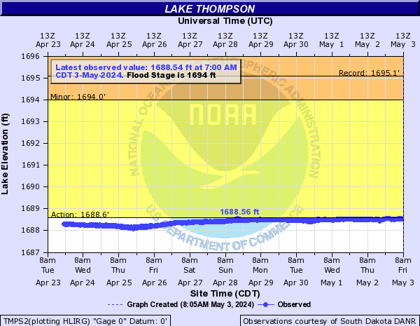
Vermillion River At Lake Thompson (TMPS2)
Return to TopNOTE: No forecasts are available for this location
Flood Stage: 1694 Feet
Latest Stage: 1688.14
Current Warnings/Statements/Advisories:None currently.
Flood Categories (in feet)
| Major Flood Stage: |
0 |
| Moderate Flood Stage: |
0 |
| Flood Stage: |
1694 |
| Action Stage: |
1688.6 |
| Low Stage (in feet): |
-9999 |
Historic Crests
(1) 1,695.08 ft on 10/08/2019
(2) 1,695.05 ft on 04/25/2011
(3) 1,694.06 ft on 04/13/2020
(4) 1,693.75 ft on 04/22/1997
(5) 1,692.95 ft on 10/17/1995
Show More Historic Crests
(P): Preliminary values subject to further review.
Recent Crests
(1) 1,688.65 ft on 04/22/2023
(2) 1,694.06 ft on 04/13/2020
(3) 1,695.08 ft on 10/08/2019
(4) 1,689.20 ft on 06/05/2018
(5) 1,687.52 ft on 05/01/2017
Show More Recent Crests
(P): Preliminary values subject to further review.
Low Water Records
Currently none available.