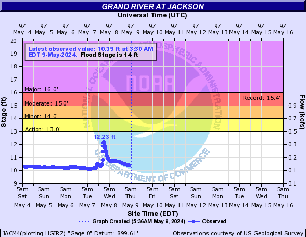
Grand River At Jackson (JACM4)
Return to TopNOTE: River forecasts for this location take into account past precipitation and the precipitation amounts expected approximately 24 hours into the future from the forecast issuance time.
NOTE: Stage may be affected by ice during winter months.
Flood Stage: 14 Feet
Latest Stage: 11.02
Current Warnings/Statements/Advisories:None currently.
Flood ImpactsIf you notice any errors in the below information, please contact our Webmaster
16.5
Expect widespread street flooding, impassable roads and flooded basements. Expect major flooding of the industrial area downtown and businesses and residences along West Trail Street in an area east of Grand River Bridge, Lewis Street, High Street, and Losey Street.
16
Expect major flooding of residences along West Trail Street, Lewis Street, High Street, Losey Street and in areas east of Grand River Bridge. Railroad tracks inundated in low lying areas along river.
15
Expect moderate flooding of residences along High Street, Lewis Street, and Losey Street. High water would disrupt traffic and damage residences.
14
Expect minor flooding of low lying areas.
13
River is bankfull. River begins to flow into low lying areas.
Flood Categories (in feet)
| Major Flood Stage: |
16 |
| Moderate Flood Stage: |
15 |
| Flood Stage: |
14 |
| Action Stage: |
13 |
| Low Flow (in CFS): |
-9999 |
Historic Crests
(1) 15.44 ft on 06/25/1968
(2) 15.20 ft on 08/17/1995
(3) 15.12 ft on 08/16/2016
(4) 14.81 ft on 08/12/2021
(5) 14.77 ft on 10/09/2021
(P)
Show More Historic Crests
(P): Preliminary values subject to further review.
Recent Crests
(1) 14.77 ft on 10/09/2021
(P)
(2) 14.81 ft on 08/12/2021
(3) 14.35 ft on 05/18/2020
(4) 13.25 ft on 06/05/2019
(5) 14.59 ft on 09/01/2018
Show More Recent Crests
(P): Preliminary values subject to further review.
Low Water Records
(1) 8.00 ft on 08/22/1936
Grand River At Eaton Rapids (ETNM4)
Return to TopNOTE: River forecasts for this location take into account past precipitation and the precipitation amounts expected approximately 24 hours into the future from the forecast issuance time.
NOTE: Stage may be affected by ice during winter months.
Flood Stage: 0 KCFS
Latest Flow: n/a
Current Warnings/Statements/Advisories:None currently.
Flood ImpactsIf you notice any errors in the below information, please contact our Webmaster
9
Expect major flooding of structures on Hall Street, west of Hamlin Street, and West Knight Street. Water is curb deep on Main Street.
7
Expect minor flooding of the business district in Eaton Rapids. Island Park in the City of Eaton Rapids is flooded.
6
Expect minor flooding of low lying areas and basements along River Street in Eaton Rapids. Island Park in the City of Eaton Rapids begins to flood.
5
River is bankfull. Expect minor overflow into low lying areas.
Flood Categories (in feet)
| Major Flood Stage: |
9 |
| Moderate Flood Stage: |
8 |
| Flood Stage: |
6 |
| Action Stage: |
5 |
| Low Stage (in feet): |
-9999 |
Historic Crests
(1) 9.10 ft on 04/06/1947
(2) 7.10 ft on 05/27/1937
(3) 7.00 ft on 04/05/1950
(4) 6.50 ft on 03/20/1948
(5) 6.20 ft on 05/01/1956
Show More Historic Crests
(P): Preliminary values subject to further review.
Recent Crests
(1) 4.95 ft on 05/15/2018
(2) 6.20 ft on 02/23/2018
(3) 4.60 ft on 04/21/2013
(4) 4.75 ft on 12/06/2011
(5) 5.60 ft on 05/27/2011
Show More Recent Crests
(P): Preliminary values subject to further review.
Low Water Records
Currently none available.
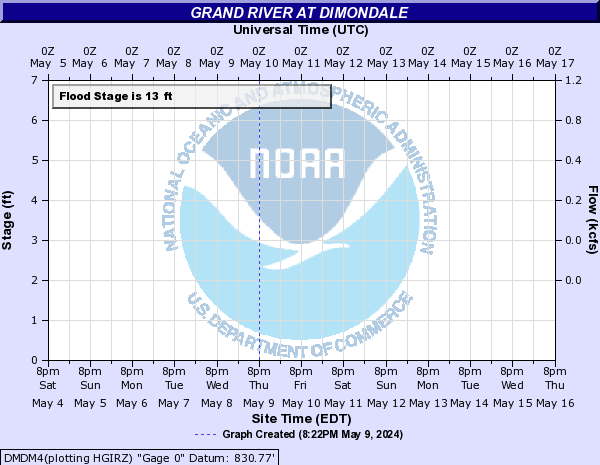
Grand River At Dimondale (DMDM4)
Return to TopNOTE: River forecasts for this location take into account past precipitation and the precipitation amounts expected approximately 24 hours into the future from the forecast issuance time.
NOTE: Stage may be affected by ice during winter months.
Flood Stage: 13 Feet
Latest Stage: 5.25
Current Warnings/Statements/Advisories:None currently.
Flood ImpactsIf you notice any errors in the below information, please contact our Webmaster
16
Expect major flooding of low lying areas and homes downstream of Dimondale and in the Grande Pointe subdivision downstream of Dimondale. Subdivision is connected to the Grand River by a series of canals and contains 83 homes.
14
Expect moderate flooding of low lying areas and homes downstream of Dimondale and in the Grande Pointe subdivision downstream of Dimondale. Subdivision is connected to the Grand River by a series of canals and contains 83 homes.
13
Expect minor flooding of low lying areas and homes downstream of Dimondale and in the Grande Pointe subdivision downstream of Dimondale. Subdivision is connected to the Grand River by a series of canals and contains 83 homes.
11
River is bankfull. Expect minor flooding of low lying areas.
Flood Categories (in feet)
| Major Flood Stage: |
16 |
| Moderate Flood Stage: |
14 |
| Flood Stage: |
13 |
| Action Stage: |
11 |
| Low Stage (in feet): |
-9999 |
Historic Crests
(1) 13.60 ft on 04/06/1947
(2) 13.30 ft on 04/19/1975
(3) 12.92 ft on 02/26/1985
(4) 12.50 ft on 03/10/1950
(5) 11.90 ft on 04/01/1960
Show More Historic Crests
(P): Preliminary values subject to further review.
Recent Crests
(1) 6.40 ft on 10/28/2021
(2) 7.70 ft on 05/22/2020
(3) 8.11 ft on 01/13/2020
(4) 7.81 ft on 06/21/2019
(5) 7.36 ft on 03/05/2019
Show More Recent Crests
(P): Preliminary values subject to further review.
Low Water Records
(1) 2.49 ft on 08/14/2008
Grand River At Lansing (LNSM4)
Return to TopNOTE: River forecasts for this location take into account past precipitation and the precipitation amounts expected approximately 24 hours into the future from the forecast issuance time.
NOTE: Stage may be affected by ice during winter months.
Flood Stage: 11 Feet
Latest Stage: 5.41
Current Warnings/Statements/Advisories:None currently.

Flood ImpactsIf you notice any errors in the below information, please contact our Webmaster
17
Expect widespread major flooding of industries, businesses, and residences in the Lansing area.
15.5
Expect road closures and major flooding of residences and businesses in North Lansing, in the Cherry Hill neighborhood, Tecumseh River Drive, Willow Street and in Edmore Park area.
15
Expect major flooding of homes and businesses in low lying areas adjacent to the river. High water also begins to affect the railroad switch yard.
14
Expect moderate flooding of homes along Willow Street, Roosevelt Street and in the Cherry Hill neighborhood along the river.
13.5
Expect moderate flooding of residences and businesses along Pennsylvania Avenue at Lindbergh drive and the Potter Creek area.
12
Expect minor flooding of basements of businesses in North Lansing.
11
Expect minor flooding of low lying areas and parks.
10
River is bankfull.
Flood Categories (in feet)
| Major Flood Stage: |
15 |
| Moderate Flood Stage: |
13 |
| Flood Stage: |
11 |
| Action Stage: |
10 |
| Low Stage (in feet): |
-9999 |
Historic Crests
(1) 15.43 ft on 04/20/1975
(2) 14.62 ft on 02/23/2018
(3) 14.12 ft on 02/26/1985
(4) 13.40 ft on 03/17/1982
(5) 13.40 ft on 03/21/1948
Show More Historic Crests
(P): Preliminary values subject to further review.
Recent Crests
(1) 11.72 ft on 05/20/2020
(2) 11.09 ft on 01/14/2020
(3) 9.33 ft on 06/21/2019
(4) 14.62 ft on 02/23/2018
(5) 12.25 ft on 04/08/2017
Show More Recent Crests
(P): Preliminary values subject to further review.
Low Water Records
(1) 0.85 ft on 09/09/1963
(2) 1.20 ft on 07/20/1965
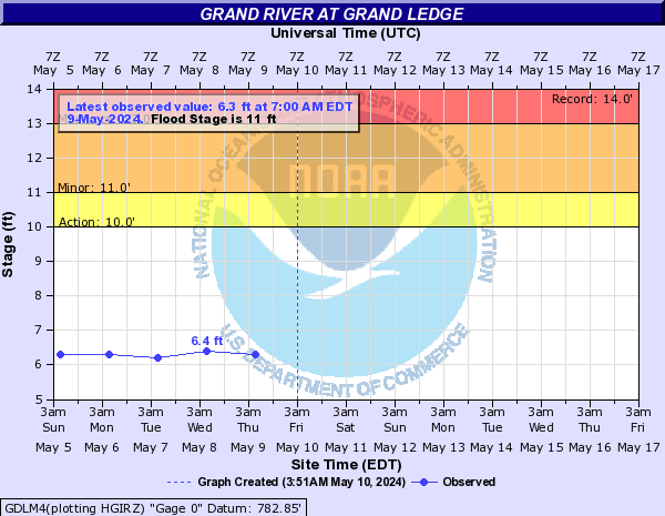
Grand River At Grand Ledge (GDLM4)
Return to TopNOTE: River forecasts for this location take into account past precipitation and the precipitation amounts expected approximately 24 hours into the future from the forecast issuance time.
NOTE: Stage may be affected by ice during winter months.
Flood Stage: 11 Feet
Latest Stage: 6.7
Current Warnings/Statements/Advisories:None currently.
Flood ImpactsIf you notice any errors in the below information, please contact our Webmaster
15
High water affects the Water and Sewage Plant in Grand Ledge. Expect major flooding in the area.
11
Expect minor flooding in low lying areas and farmland along the river.
10
River is bankfull.
8
Expect minor flooding of islands located near the gage.
Flood Categories (in feet)
| Major Flood Stage: |
15 |
| Moderate Flood Stage: |
13 |
| Flood Stage: |
11 |
| Action Stage: |
10 |
| Low Stage (in feet): |
-9999 |
Historic Crests
(1) 14.00 ft on 03/26/1904
(2) 12.00 ft on 04/07/1947
(3) 11.90 ft on 02/16/1918
(4) 11.51 ft on 03/19/1982
(5) 11.40 ft on 03/14/1920
Show More Historic Crests
(P): Preliminary values subject to further review.
Recent Crests
(1) 8.00 ft on 08/12/2021
(2) 9.00 ft on 05/21/2020
(3) 8.00 ft on 06/21/2019
(4) 8.00 ft on 05/16/2018
(5) 8.40 ft on 04/20/2013
Show More Recent Crests
(P): Preliminary values subject to further review.
Low Water Records
Currently none available.
Grand River At Portland (PORM4)
Return to TopNOTE: River forecasts for this location take into account past precipitation and the precipitation amounts expected approximately 24 hours into the future from the forecast issuance time.
NOTE: Stage may be affected by ice during winter months.
Flood Stage: 12 Feet
Latest Stage: 7.11
Current Warnings/Statements/Advisories:None currently.
Flood ImpactsIf you notice any errors in the below information, please contact our Webmaster
16
Expect major flooding of the business district and residential areas in the Village of Lyons and basement flooding of residences on the west side of Kent Street in Portland.
14
Expect moderate flooding of the first floor of residences and businesses in the south section of the Village of Lyons. Elizabeth, Superior, and Railroad Streets in the Village of Lyons closed due to flooding.
12
Expect minor flooding in the Village of Lyons and low lying areas adjacent to the river. Two Rivers Park in Portland flooded.
11
River is bankfull. Expect minor flooding of low areas along the river upstream and downstream of Portland.
Flood Categories (in feet)
| Major Flood Stage: |
16 |
| Moderate Flood Stage: |
14 |
| Flood Stage: |
12 |
| Action Stage: |
11 |
| Low Stage (in feet): |
-9999 |
Historic Crests
(1) 12.98 ft on 04/21/1975
(2) 12.84 ft on 05/24/2004
(3) 12.62 ft on 02/23/2018
(4) 12.45 ft on 02/27/2019
(5) 12.05 ft on 03/17/1982
Show More Historic Crests
(P): Preliminary values subject to further review.
Recent Crests
(1) 10.59 ft on 06/27/2021
(2) 11.32 ft on 05/19/2020
(3) 10.90 ft on 06/20/2019
(4) 12.45 ft on 02/27/2019
(5) 12.62 ft on 02/23/2018
Show More Recent Crests
(P): Preliminary values subject to further review.
Low Water Records
(1) 3.84 ft on 10/10/1963
(2) 4.00 ft on 09/13/1963
(3) 4.04 ft on 08/23/1965
Grand River At Ionia (IONM4)
Return to TopNOTE: River forecasts for this location take into account past precipitation and the precipitation amounts expected approximately 24 hours into the future from the forecast issuance time.
NOTE: Stage may be affected by ice during winter months.
Flood Stage: 21 Feet
Latest Stage: 12.39
Current Warnings/Statements/Advisories:None currently.

Flood ImpactsIf you notice any errors in the below information, please contact our Webmaster
25
Expect major flooding of Ionia Fairgrounds and businesses and residences in low lying areas near the river. Railroad tracks and several additional businesses flooded in vicinity of Fairgrounds along Steele Street. Homes along Quarry Road flooded.
23
Expect moderate flooding of several roads, businesses, and residences, in the Ionia area and of structures located in the Ionia Fairgrounds. Water halfway up windows on automobile building at Ionia Fairgrounds. Water begins to flood parking lot of Dollar General store, Save-a-Lot, and the Ionia Secretary of State office. Homes along Quarry Road begin to flood.
21
Expect minor flooding of several buildings in the Ionia Fairgrounds, a shopping mall near the Fairgrounds, and several businesses and residences in the southern portion of Ionia.
18
Water surrounds automobile building at Ionia Fairgrounds.
16
Expect extensive lowland overflow to occur.
15
High water affects North Drive on Ionia Fairgrounds.
13.5
River is bankfull. Minor overflow begins in low lying areas along the river near and across from the Ionia Fairground.
Flood Categories (in feet)
| Major Flood Stage: |
25 |
| Moderate Flood Stage: |
23 |
| Flood Stage: |
21 |
| Action Stage: |
13.5 |
| Low Stage (in feet): |
-9999 |
Historic Crests
(1) 24.69 ft on 04/20/2013
(2) 24.40 ft on 02/23/2018
(3) 24.30 ft on 03/21/1948
(4) 23.60 ft on 04/07/1947
(5) 23.43 ft on 04/01/1960
Show More Historic Crests
(P): Preliminary values subject to further review.
Recent Crests
(1) 19.93 ft on 06/29/2021
(2) 23.20 ft on 05/20/2020
(3) 19.89 ft on 03/16/2019
(4) 24.40 ft on 02/23/2018
(5) 22.12 ft on 04/08/2017
Show More Recent Crests
(P): Preliminary values subject to further review.
Low Water Records
(1) 5.61 ft on 07/16/1977
(2) 6.20 ft on 09/08/1954
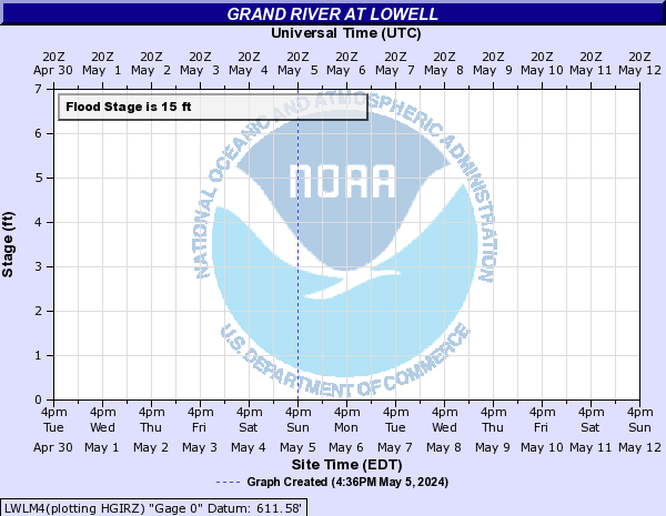
Grand River At Lowell (LWLM4)
Return to TopNOTE: River forecasts for this location take into account past precipitation and the precipitation amounts expected approximately 24 hours into the future from the forecast issuance time.
NOTE: Stage may be affected by ice during winter months.
Flood Stage: 0 KCFS
Latest Flow: n/a
Current Warnings/Statements/Advisories:None currently.
Flood ImpactsIf you notice any errors in the below information, please contact our Webmaster
24
Expect major flooding of businesses and residences in the Lowell area. Railroad embankment on south bank overtopped.
20
Expect major flooding of businesses and residences in the Lowell area and high water affects the business district.
18
Expect moderate flooding of commercial buildings.
16
Lowell fairgrounds flooded, low sections of Bowes Road, Division, Front Street, and Jackson flooded in the city of Lowell.
15
Expect minor flooding of commercial buildings.
10
River is bankfull. Expect flooding of low lying areas adjacent to the banks.
Flood Categories (in feet)
| Major Flood Stage: |
20 |
| Moderate Flood Stage: |
18 |
| Flood Stage: |
15 |
| Action Stage: |
10 |
| Low Stage (in feet): |
-9999 |
Historic Crests
(1) 19.02 ft on 04/21/2013
(2) 19.00 ft on 03/22/1948
(3) 18.50 ft on 04/08/1947
(4) 18.20 ft on 02/24/2018
(5) 17.80 ft on 03/19/1942
Show More Historic Crests
(P): Preliminary values subject to further review.
Recent Crests
(1) 10.14 ft on 02/18/2022
(2) 13.25 ft on 06/30/2021
(3) 17.23 ft on 05/21/2020
(4) 13.80 ft on 03/18/2019
(5) 18.20 ft on 02/24/2018
Show More Recent Crests
(P): Preliminary values subject to further review.
Low Water Records
Currently none available.
Grand River At Ada (ADAM4)
Return to TopNOTE: River forecasts for this location take into account past precipitation and the precipitation amounts expected approximately 24 hours into the future from the forecast issuance time.
NOTE: Stage may be affected by ice during winter months.
Flood Stage: 20 Feet
Latest Stage: 10.34
Current Warnings/Statements/Advisories:None currently.
Flood ImpactsIf you notice any errors in the below information, please contact our Webmaster
29
Alticor Inc. Catalog and Powder Complex flood.
27
Alticor Inc. buildings number 34 and 58 flood.
24.5
Inner dike along Alticor Inc. overtopped. East complex on Alticor Inc. floods.
21.6
500 parking spaces in the Alticor Inc. parking lot are inundated and one gate into the Alticor Inc. complex is closed due to the high water. Ada River Walk near Covered Bridge and Leonard Field Ball Park in Ada flooded.
20.7
Floodwaters begin to affect walkways along the river near downtown Ada.
20.5
Chief Hazy Cloud Park downstream of gage begins to flood.
20
Expect minor flooding of low lying areas.
17
River is bankfull. Shady Drive floods.
13
Water starts to impact low spots on the walking and biking trails along the river in Roselle Park.
Flood Categories (in feet)
| Major Flood Stage: |
25 |
| Moderate Flood Stage: |
22 |
| Flood Stage: |
20 |
| Action Stage: |
17 |
| Low Stage (in feet): |
-9999 |
Historic Crests
(1) 22.81 ft on 04/21/2013
(2) 22.56 ft on 02/24/2018
(3) 21.62 ft on 05/21/2020
(4) 21.60 ft on 02/28/1986
(5) 21.56 ft on 05/26/2004
Show More Historic Crests
(P): Preliminary values subject to further review.
Recent Crests
(1) 17.25 ft on 06/30/2021
(2) 21.62 ft on 05/21/2020
(3) 17.78 ft on 03/17/2019
(4) 22.56 ft on 02/24/2018
(5) 19.89 ft on 04/09/2017
Show More Recent Crests
(P): Preliminary values subject to further review.
Low Water Records
Currently none available.
Grand River At Comstock Park (CMPM4)
Return to TopNOTE: River forecasts for this location take into account past precipitation and the precipitation amounts expected approximately 48 hours into the future from the forecast issuance time.
NOTE: Stage may be affected by ice during winter months.
Flood Stage: 0 KCFS
Latest Flow: n/a
Current Warnings/Statements/Advisories:None currently.
Flood ImpactsIf you notice any errors in the below information, please contact our Webmaster
16
Major flooding on homes along Abrigador Trail, Willow Drive, Riverbank Street and Konkle Drive. In Comstock Park and Plainfield Township approximately 100 homes affected by flooding.
14
Homes along Willow Drive and Abrigador Trail have flooded basements and Abrigador Trail is closed. Riverbank Street northeast in Plainfield Township is flooded and homes along Riverbank Street have flooded basements. Konkle Drive northeast in Plainfield township is flooded.
13
Abrigador Trail is underwater and minor flooding of homes occurs along Abrigador Trail and Willow Drive.
12
Expect minor flooding of homes along Abrigador Trail.
11
River is bankfull.
Flood Categories (in feet)
| Major Flood Stage: |
16 |
| Moderate Flood Stage: |
14 |
| Flood Stage: |
12 |
| Action Stage: |
11 |
| Low Stage (in feet): |
-9999 |
Historic Crests
(1) 17.80 ft on 04/21/2013
(2) 17.75 ft on 03/22/1948
(3) 17.45 ft on 04/09/1947
(4) 16.85 ft on 02/25/2018
(5) 16.70 ft on 03/01/1985
Show More Historic Crests
(P): Preliminary values subject to further review.
Recent Crests
(1) 13.30 ft on 02/25/2022
(2) 12.80 ft on 07/01/2021
(3) 12.80 ft on 06/30/2021
(4) 16.40 ft on 05/21/2020
(5) 13.80 ft on 01/15/2020
Show More Recent Crests
(P): Preliminary values subject to further review.
Low Water Records
Currently none available.
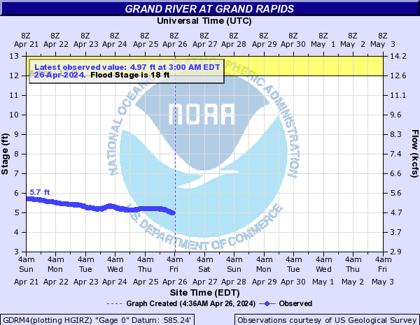
Grand River At Grand Rapids (GDRM4)
Return to TopNOTE: River forecasts for this location take into account past precipitation and the precipitation amounts expected approximately 24 hours into the future from the forecast issuance time.
NOTE: Stage may be affected by ice during winter months.
Flood Stage: 18 Feet
Latest Stage: 6.01
Current Warnings/Statements/Advisories:None currently.
Flood ImpactsIf you notice any errors in the below information, please contact our Webmaster
25.5
Expect major flooding downtown with high water impacting the Van Andel Museum.
23
Expect major flooding of residential areas above and below Downtown Grand Rapids.
21.69
High water impacts the Waste Water Treatment Plant in Grand Rapids.
21
Expect moderate to major flooding in the area, Ann Street, and the city dikes. Major flooding of homes and structures occurs upstream in Comstock Park and downstream of Grand Rapids to Robinson Township.
18
Expect minor flooding of basements in low lying areas in Grand Rapids. Moderate flooding of homes and structures occurs upstream at Comstock Park and downstream in Robinson Township.
16.5
Expect minor flooding in Grandville.
15
Expect minor flooding to occur in low lying areas upstream and downstream of Grand Rapids, especially in the areas of North Park, Comstock Park, and Robinson Township. Some seepage into basements of businesses in Grand Rapids occurs.
14
Expect minor flooding to occur in low lying areas upstream and downstream of Grand Rapids, especially in the areas of North Park and Comstock Park.
12
River is bankfull upstream and downstream of flood walls in Downtown Grand Rapids. Portions of the Kent Trail and Indian Mounds Drive flooded in Grandville.
Flood Categories (in feet)
| Major Flood Stage: |
23 |
| Moderate Flood Stage: |
21 |
| Flood Stage: |
18 |
| Action Stage: |
12 |
| Low Stage (in feet): |
-9999 |
Historic Crests
(1) 21.85 ft on 04/21/2013
(2) 20.67 ft on 02/25/2018
(3) 19.64 ft on 03/01/1985
(4) 19.55 ft on 05/22/2020
(5) 19.54 ft on 05/27/2004
(6) 19.50 ft on 03/28/1904
(7) 19.29 ft on 03/08/1976
(8) 19.25 ft on 04/03/1960
(9) 19.25 ft on 10/04/1986
(10) 18.86 ft on 04/09/2023
(P)
Show More Historic Crests
(P): Preliminary values subject to further review.
Recent Crests
(1) 18.86 ft on 04/09/2023
(P)
(2) 14.28 ft on 07/01/2021
(3) 19.55 ft on 05/22/2020
(4) 15.71 ft on 03/18/2019
(5) 20.67 ft on 02/25/2018
(6) 17.90 ft on 04/10/2017
(7) 12.31 ft on 04/04/2016
(8) 10.26 ft on 03/17/2015
(9) 12.79 ft on 03/25/2014
(10) 21.85 ft on 04/21/2013
Show More Recent Crests
(P): Preliminary values subject to further review.
Low Water Records
(1) 0.30 ft on 11/05/1953
(2) 2.25 ft on 08/17/1936
Grand River Near Eastmanville (EASM4)
Return to TopNOTE: No forecasts are available for this location
NOTE: Stage may be affected by ice during winter months.
Flood Stage: Not available
Latest Stage: 11.93
Current Warnings/Statements/Advisories:None currently.
Flood Categories (in feet)
Historic Crests
(1) 20.37 ft on 04/22/2013
(2) 19.62 ft on 02/26/2018
(3) 19.01 ft on 05/23/2020
(4) 17.66 ft on 04/11/2017
(5) 16.47 ft on 03/18/2019
Show More Historic Crests
(P): Preliminary values subject to further review.
Recent Crests
(1) 15.53 ft on 07/01/2021
(2) 19.01 ft on 05/23/2020
(3) 16.47 ft on 03/18/2019
(4) 19.62 ft on 02/26/2018
(5) 17.66 ft on 04/11/2017
Show More Recent Crests
(P): Preliminary values subject to further review.
Low Water Records
Currently none available.